The first significant heat of the spring and summer season is on the way in the days ahead.
Issued at 1500BST on Tue 23rd May based on Tue 23rd May 00Z Model Runs
Key Points
Discussion:
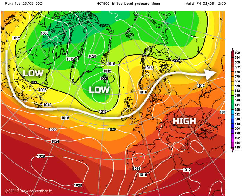
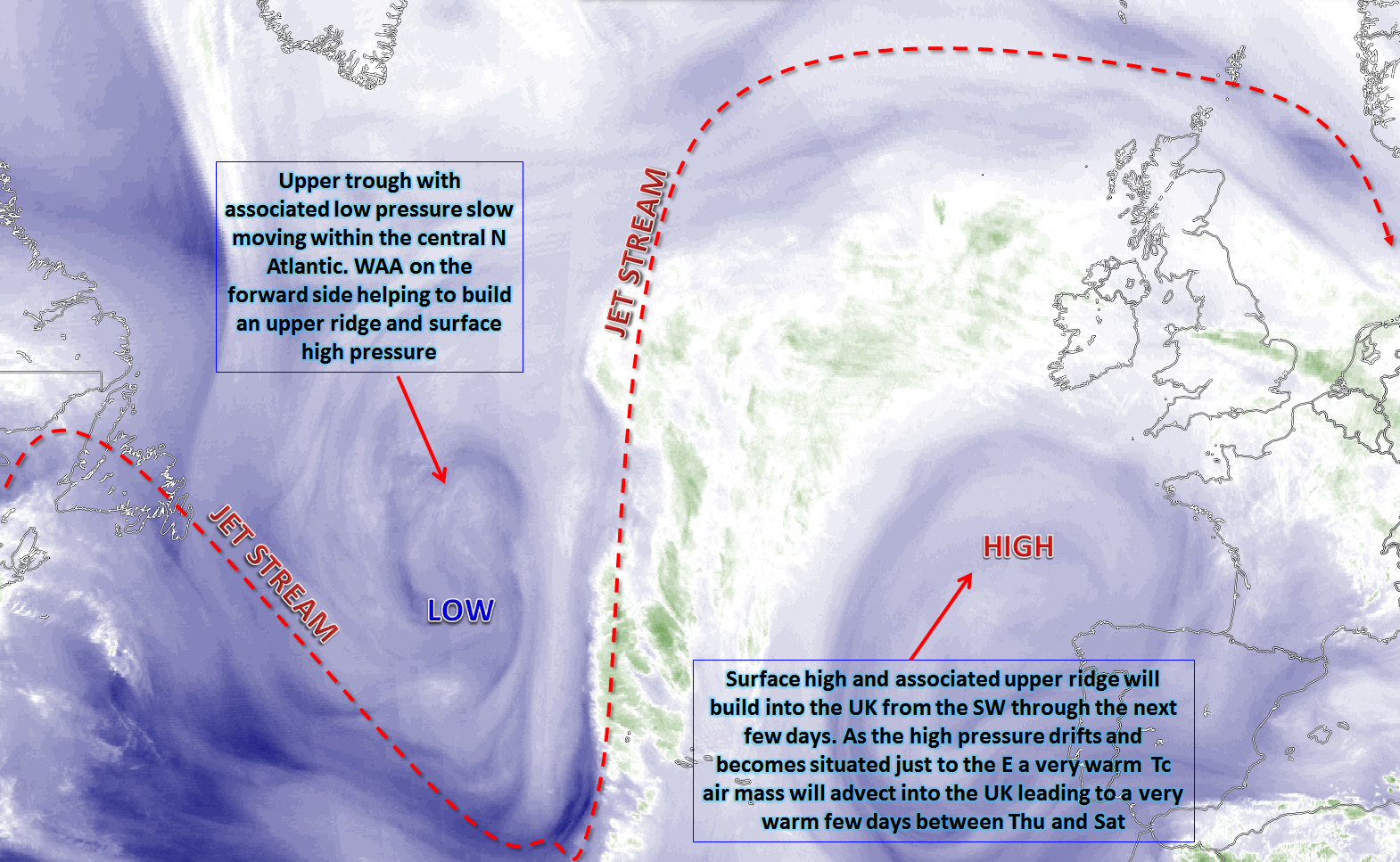
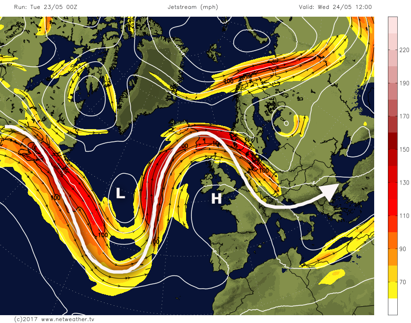
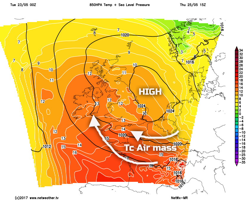
Wed 24th May: Into Wednesday and the building blocks will be in place for the development of some hot weather across the UK. An amplified pattern is expected to exist across the N Atlantic, with an upper trough within the N Atlantic, while downstream, across NW Europe, a building region of high pressure will take place. WAA on the forward (east) side of the upper trough will be the main feature in aiding to increase GPH across the UK. As the centre of gravity of the high pressure becomes situated more to the E of the UK, this will be when a Tc air mass arrives into the UK, from the S, from Thursday onwards. The broader synoptic pattern into Wednesday is highlighted well by the 00Z GFS.
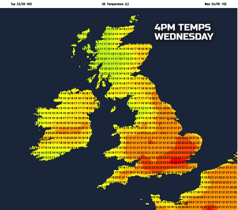
The anticyclone will dominate the weather through Wednesday and will bring a significant amount of subsidence across the UK and, hence, bright or sunny spells are likely. Forecast soundings do show the potential for Sc or Cu type clouds within the lower layers of the atmosphere, so a ‘blue sky’ day is not to be expected. Weak fronts moving around the periphery of the high pressure may bring some thicker cloud to the far N of Scotland and the N Isles through the day, with some patchy light rain or drizzle here. Temperatures will respond to the increasingly warm air mass, especially when combined with the ‘strong’ late May sunshine and it will be a pleasantly warm day.
Thu 25th May: Through into Thursday and after warm night, temperatures will quickly rise across many inland areas through the morning. The main anticyclone, by this point, will be drifting just to the E of the UK, within the N Sea and there is a good model agreement between the ECMWF, GFS, GEM and UKMO for this to occur. As a result, it is through Thursday that a particularly warm air mass will arrive from the S. There are many variables to look at, to gauge air mass. However, using our MR model you can see that 850mb temps do rise to near +12C or more across much of the UK, indicating the hot air mass that gets advected into the UK from the S and SE.
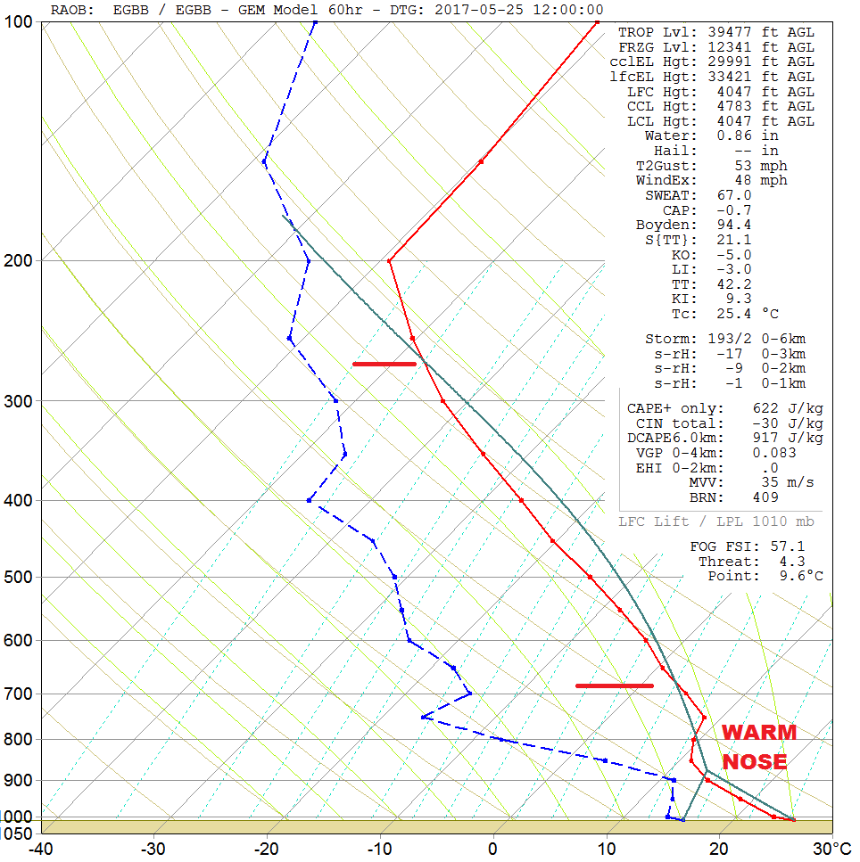
The weather across much of the UK through the day will remain anticyclonic. However, there is likely to be a greater propensity of the cloud to break through the day, allowing the potential, at least, for more prolonged spells of sunshine to develop. Forecast soundings do show the potential as well for some mid-level instability, as indicated in the forecast sounding for Birmingham. The predicted surface temperature of +25C with a dewpoint of +16C does lead to potential instability, as highlighted. However, the small ‘warm nose’, located between 800mb and 700mb, will prohibit convection from occurring with, as a result, just broken Cu-type cloud likely.
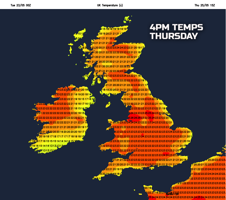
Clearly, emphasis will be on the dramatic rise in temperatures as the day progresses. Many inland areas of the UK will see temperatures range between 20C and 25C, always cooler around coastal regions with some sea breezes developing too. Across urban areas of England and Wales, then temperatures more than 25C is certainly possible. A warm and uncomfortable night will then follow. This primarily due to the landmass struggling to radiate the intense heat of the day and with some unusually high minimum temperatures likely, again especially in urban areas.
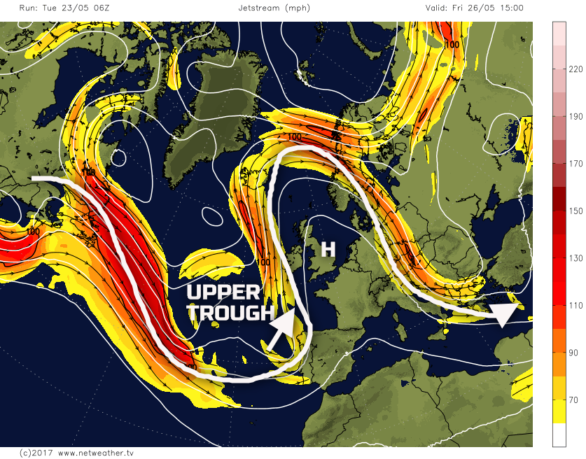
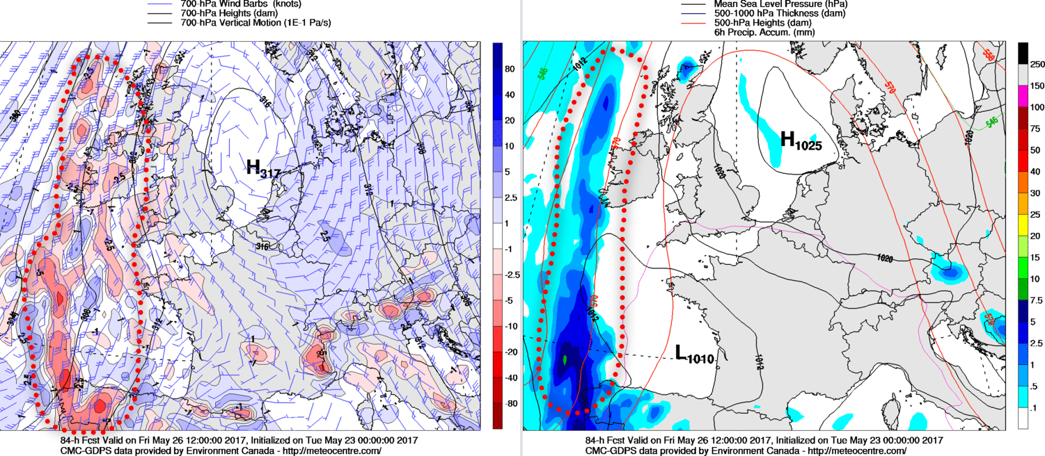
Fri 26th May: We end the working week with the majority of the UK dominated by an intense spell of high temperatures. The hot air mass from the near Continent will be established and day-on-day sensible heating of the landmass, a dry landmass as well, means that a hot day is predicted. Temperatures, overall, will be similar to that of the forecast on Thursday, but perhaps with a greater risk of somewhere nearing 28C to 30C. Urban areas, in particular, will experience some rather uncomfortable conditions, as humidity begins to rise as well. The overall broader synoptic pattern will remain similar, but there will be a subtle difference. That main difference is the approach of an upper trough into the far W and SW of the UK. The continued eastward progression of the main surface high continues to be modelled well by all the 00Z GM’s (UKMO, GFS, GEM and ECMWF). More of a cyclonic flow then arrives into the far W and SW of the UK which may well then help to destabilise the hot air mass over the UK.
It is at this point when the details become uncertain. As is often the case with this type of synoptic transition, the devil is most certainly in the detail. Overall though, for much of the UK, Friday will continue to be dominated by anticyclonic conditions. As a result, another dry day is expected for many with just variable cloud and with plenty of hot sunshine too. There is only a small and isolated risk that the atmosphere will destabilise over inland areas of the UK through the day, perhaps over higher ground of the Pennines and Scotland, but, again, this risk is minimal. The main region of more active weather could well be across parts of Ireland and perhaps SW England. Here as the upper trough, with associated vorticity approaches, then some heavy showers or thundery conditions may well develop.
Using the 00Z GEM model as a guide, the regions of vorticity, associated with the approaching trough, are in evidence in Ireland and the extreme SW. It is here that some precipitation is possible. Equally, and to complicate the forecast, a low surface pressure may well then develop within the Bay of Biscay later in the day.
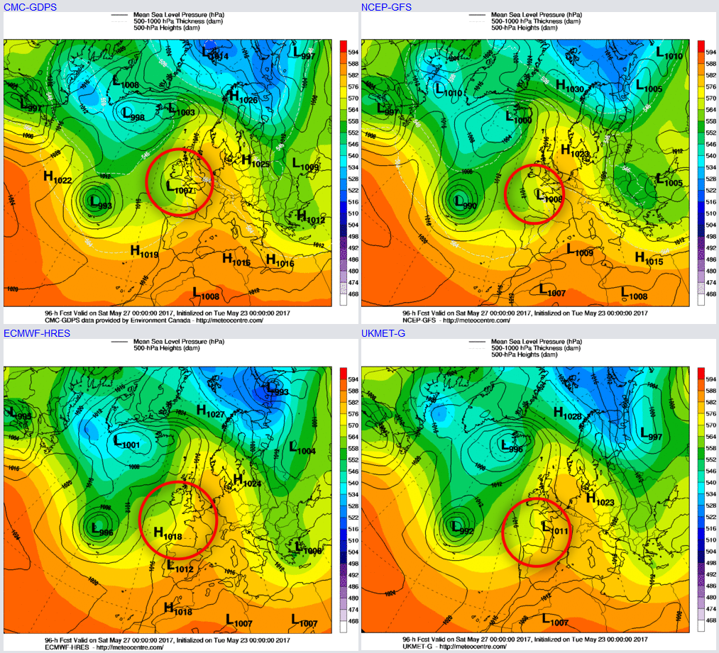
Sat 27th and Sun 28th May: Into the coming weekend and this is when the detail drops away markedly. The approaching upper trough may well coincide with the development of a surface low-pressure system, along with a frontal wave. The overall pattern though does seem to be well modelled, for now, with the significant plume of Tc air still over the UK. However, the GFS, UKMO and GEM models highlight a low-pressure system, whereas the ECMWF doesn’t.
As things stand much of the UK will have another predominantly dry on Saturday, with further bright or sunny spells, these prolonged at times. The greatest potential for dry weather to be maintained throughout the day is across more northern and eastern areas. Further S and W and here is where the risk of some heavy and thundery downpours or longer spells of heavy rain may well develop as the day progresses. Depending on the details then this risk of the thundery conditions may extend further N and E, across England and Wales, later in the day and overnight.
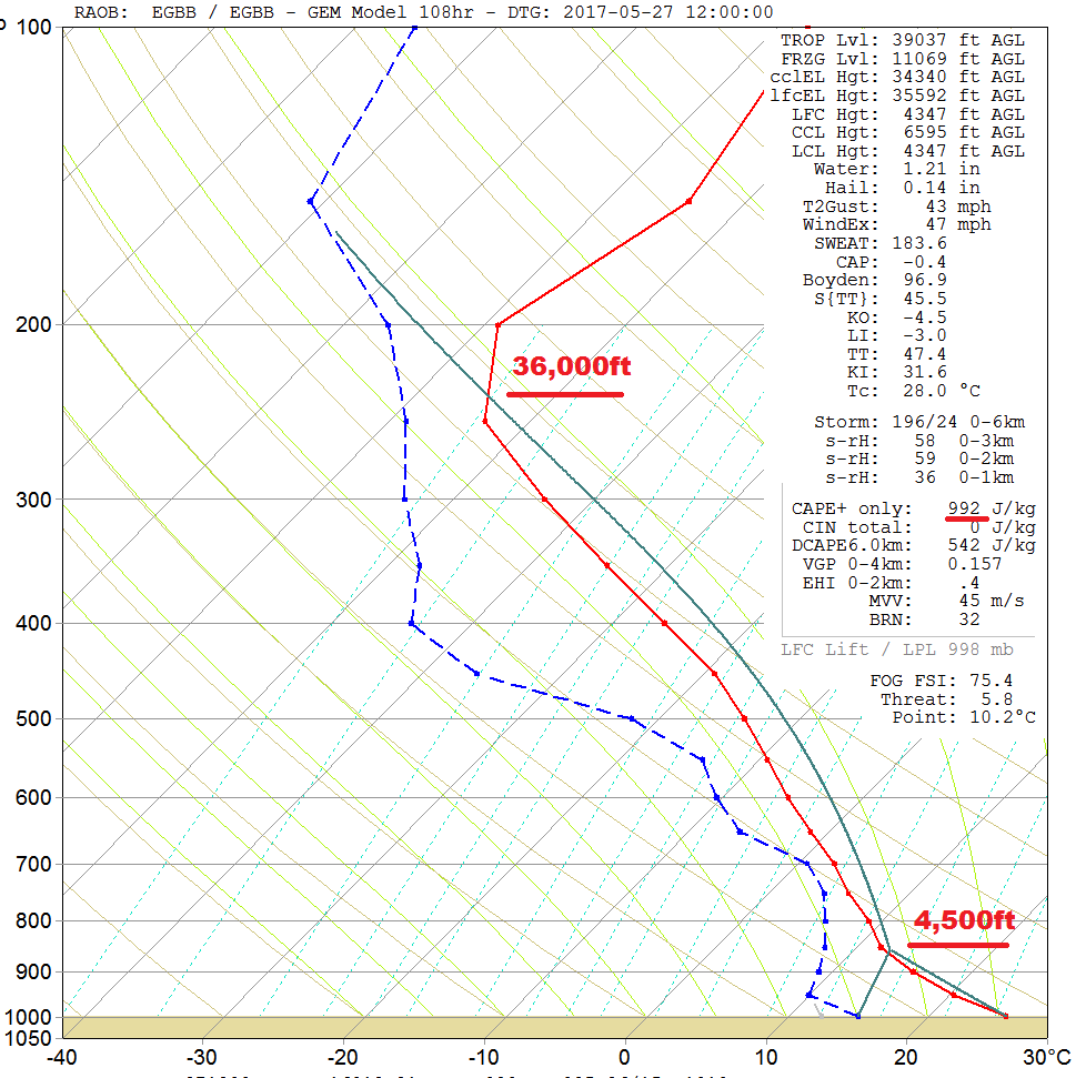
The forecast sounding for Birmingham, towards 1200Z on Saturday does support the potential development of some intense thunderstorms and downpours. Surface temperatures near +25C, when coupled with surface dew points of near +15C would be enough to produce an entirely unstable atmosphere. Cloud bases near 4,500ft would result, but with cloud tops nearing 36,000ft, primarily at the top of the troposphere. Up to 900j/kg of CAPE would result and, this would lead to the risk of some downpours and thunderstorms. However, emphasis though is on that this is all subject to change and is highly reliant on the ‘finer details’ by the time the weekend approaches.
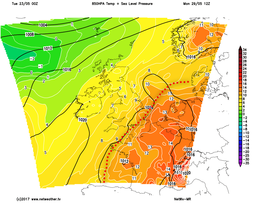
The overall pattern through the weekend though does look set to be one towards more unsettled and cooler conditions. No matter how the breakdown occurs, regarding detail, the result looks set to be the same with cooler and somewhat more unsettled conditions arriving from the west. Our MR model highlights this likely trend well. When compared with the earlier 850mb temperature chart from the end of the coming weekend, by the time we get to Bank Holiday Monday, the main plume of heat and humidity should have been displaced into the near Continent. 850mb temperatures across most of the UK are then down into ‘single figures’, with perhaps the only extreme E and SE of England still seeing any residual heat.
Medium and Longer Term 29th May onwards:
Looking forward and the outlook towards the end of the month and into early June is uncertain. This period of hot weather in the coming days did materialise in a very short space of time and, this highlights the intricacies of the overall synoptic pattern through the late spring and summer period. It doesn’t take much to change a subtle shift in the position of a ridge or a trough to then lead to the advection of much warmer conditions from the S. Overall though the outlook after this period of warmer weather is one towards more changeable and unsettled weather into early June.
Taking the 00Z GFS ENS, as an example, the overall pattern is more zonal than meridional. High pressure, within the ENS, mean, is displaced more to the SE of the UK, with lower pressure in evidence just to the W and NW. An NW and SE split in conditions may materialise, but a more unsettled and cooler period of weather predicted for now. There are, however, some signs that higher pressure may return towards mid-month, but low or very low confidence in that for now.