Latest synoptic guidance blog.
Issued at 1500BST on Tue 25th April based on Tue 25th April 00Z Model Runs
Key Points
Discussion:
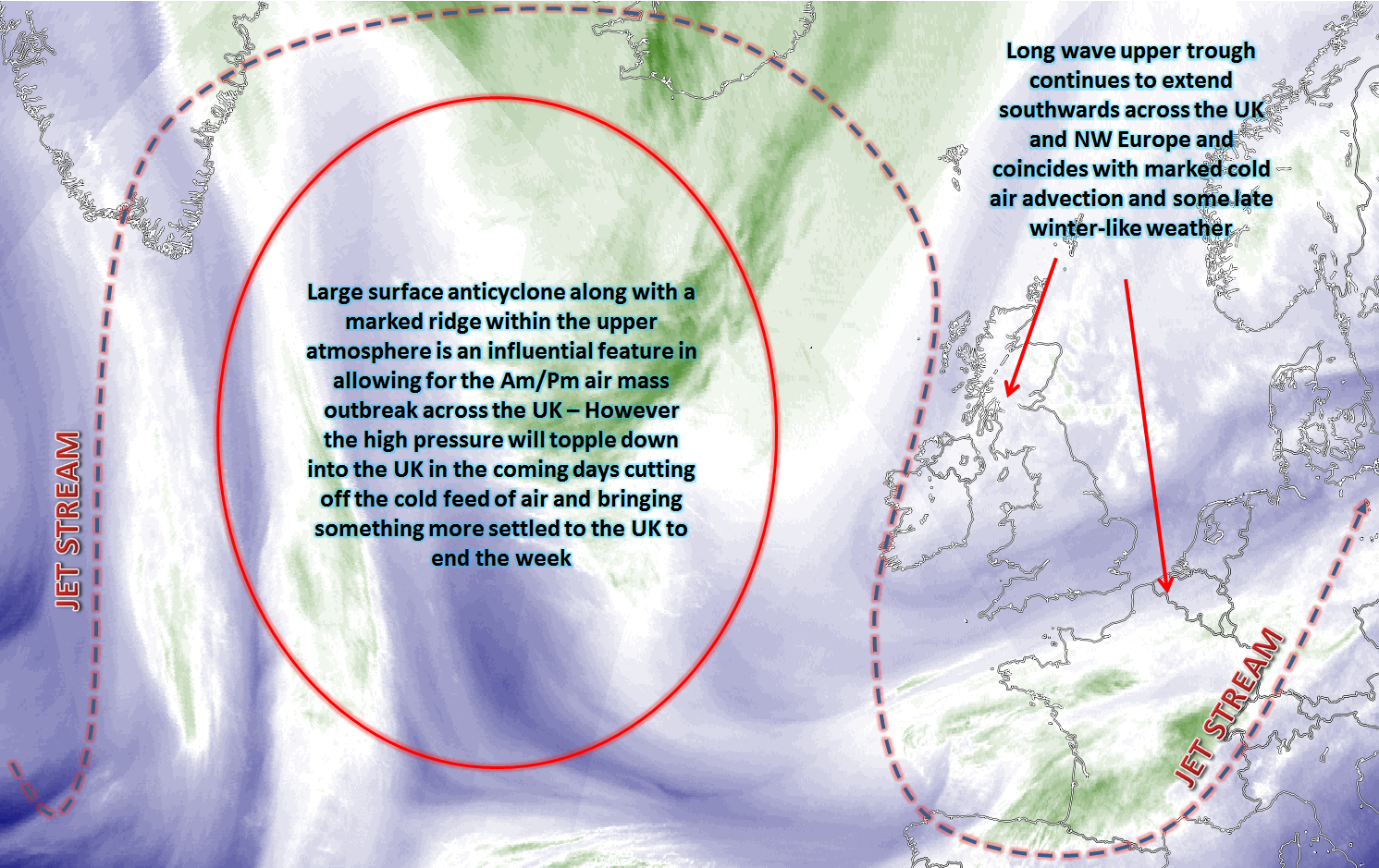
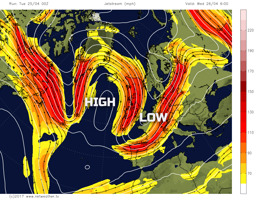
Wed 26th Apr: Into Wednesday and there is a good model agreement between the GM’s (UKMO, GEM, GFS and ECMWF) regarding what will be a particularly amplified pattern across the N Atlantic domain. A long wave upper trough, in association with marked CAA, will continue to be in evidence over most of the UK, but particularly so across England and Wales during the day. Further N and W, across Scotland and Ireland the flow will begin to become more anticyclonic, with less unstable profiles developing as higher pressure builds into these regions as the day progresses. This general pattern can be seen well on the below jet stream chart from the GFS, with emphasis on the amplified pattern and the dominant ridge-trough pattern across the N Atlantic and into the UK.
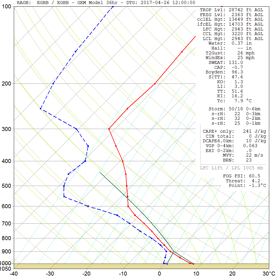
The cold Am air mass that has developed over the last 24 hours will still be in place across most of the UK, so the emphasis is certainly on further cold conditions through the day. With the upper trough in place over England and Wales, it is here that surface heating will combine with cold ULL temps to produce another day of sunshine and showers. The showers locally heavy and still perhaps wintry, especially across more central and eastern areas of England with hail and sleet to lower levels for example. The atmosphere will be less unstable further N and W as the flow becomes more anticyclonic, so far fewer showers here and, if anything, WAA will begin to take place as an area of low pressure develops to the N of Scotland. The forecast sounding for Birmingham though on Wednesday afternoon highlights the unstable atmosphere that will dominate across England and Wales.
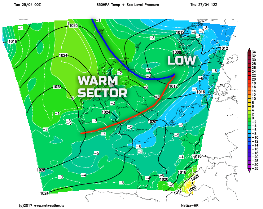
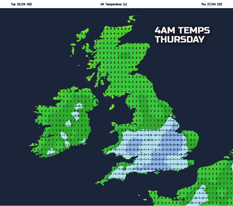
Thu 27th Apr: Into Thursday and it will be another cold start across England and Wales, given that the showery conditions on Wednesday evening will have cleared to leave clear skies overnight. As a result, another widespread frost is likely, especially across central and southern areas of England and Wales. However, the emphasis through Thursday is a change in the overall air mass across the UK. While the broader weather patterns will remain quite similar, with higher GPH to the W of the UK and lower GPH to the E, a weak area of low pressure, as signalled by most of the GM’s, will be moving down the N Sea through the day. This low pressure will permanently cut off the cold feed of air from the N, with warm sector conditions moving down across the UK through the day. This scenario is highlighted well on our MR weather model. The blue shadings, indicating the colder Am/Pm air mass moves into France, while warm sector conditions follow.
The weather through the course of Thursday will then be towards increasingly overcast and damp conditions moving down across the UK in association with the frontal zones. While a cold and sunny start across the S of the British Isles many areas will be mostly cloudy or overcast through the day with sporadic regions of mainly light or moderate, rain and drizzle moving SE as the day progresses. No widespread or heavy rain is to be expected mind simply because the frontal zones associated with the low pressure won’t be well forced, but there’ll be enough activity to the frontal zones to lead to a less cold, but mostly cloudy and increasingly damp day.
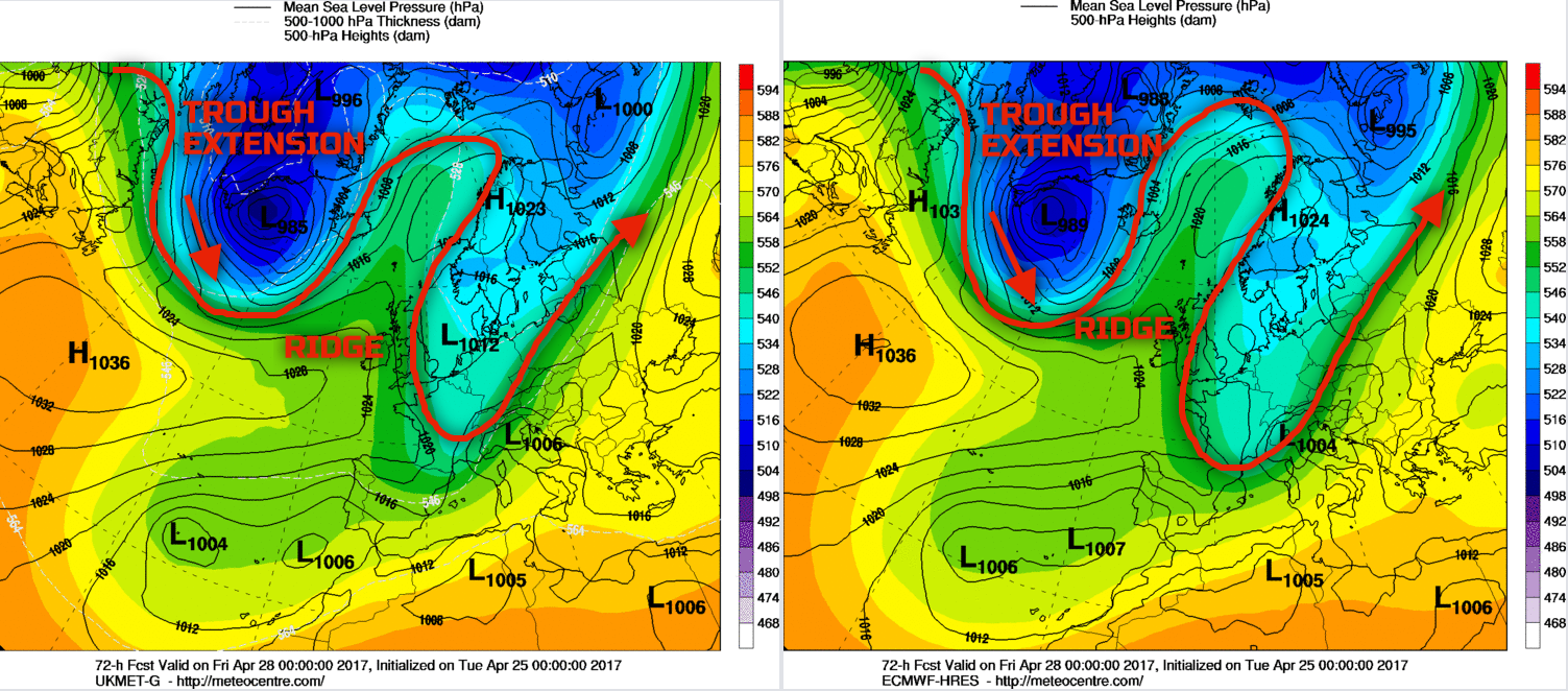
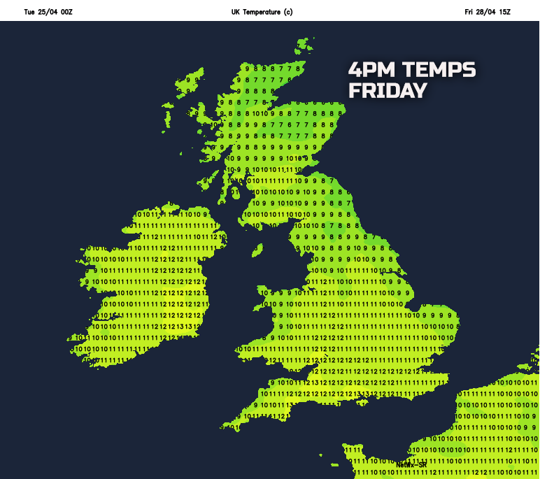
Fri 28th Apr: As we end the working week there is a good model agreement between the UKMO, GFS, ECMWF and the GEM models for a general rise in GPH across the UK with high pressure dominating the weather. Thursday’s low-pressure system will be located at the E or SE of the British Isles, but its influence on the conditions through the day will be minimal. The other important aspect of the weather through the day will include the development of a long wave upper trough out of Greenland and down into the N Atlantic, this coinciding with marked CAA too. This feature will be of interest and importance as we move through the weekend. The 00Z ECMWF and UKMO models have been used, below, to example the synoptic pattern through the day. The weather for Friday will then be benign, especially when compared to the weather earlier in the week. A less cold air mass will still be in place over the UK and with lighter winds, beneath the area of higher pressure, then it should feel a little milder at least too. A few convergence zones are in evidence on some HRES models, but overall many places will have plenty of dry weather with some bright or sunny spells and variable amounts of cloud.
Temperatures through the rest of the working week will as discussed, increase in comparison to the cold weather of present. There will be further frosts by night, especially tonight and into Wednesday and then again Wednesday night into Thursday across England and Wales. Equally, the well below average temperatures of earlier in the week will be replaced by higher temperatures by Friday so feeling a little milder, but even then temperatures will still be slightly below average for late April.
Sat 29th and Sun 30th Apr: Into the coming weekend and the synoptic evolution by this point will become particularly complicated. As a result, there are some uncertainties over the details. However, the development of a long wave trough within the N Atlantic will signal the progression towards more cyclonic conditions over the weekend across the British Isles. The central question regarding the weekend’s weather though is; how quickly will that change to more cyclonic conditions take? – At the moment, given the 00Z models Saturday may well maintain relative high GPH across the UK and, as a result, Saturday is expected to be a mainly dry day with some bright or sunny spells and just variable amounts of cloud. There is some evidence for possible local, mesoscale, convergence zones to bring some light showers perhaps, but that level of detail is unknown for now. What is then likely to happen is at the base of the long wave upper trough a surface low pressure will develop just to the SW. The 00z ECMWF, UKMO, GFS and GEM all show this development and at this lead time, there is a quite good agreement regarding this significant synoptic feature. Many S and W areas of the British Isles are likely to become unsettled through Sunday with an increasingly cyclonic S or SW’ly air mass developing along with associated front zones. Outbreaks of rain and showers will likely develop, some perhaps heavy precipitation is possible too. The further N and E you are, essentially furthest away from the developing low to the SW, then further dry weather is likely on Sunday and Scotland, in particular, may well hold on to dry weather throughout most of the day.
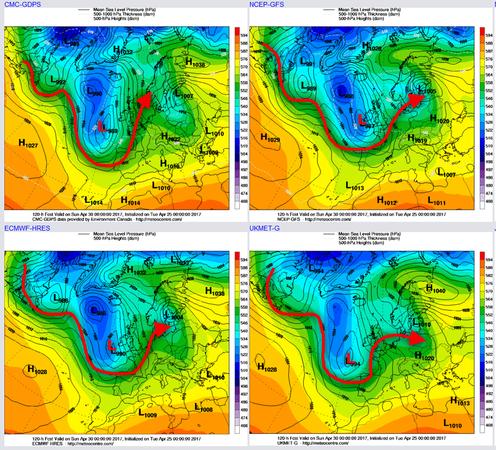
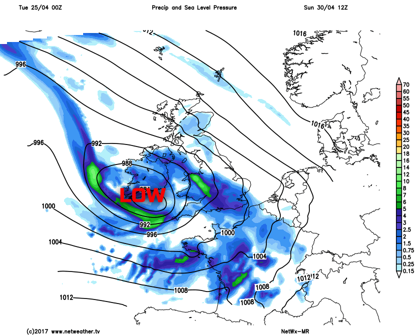
Our MR model is also showing some reasonable agreement with the GM’s too. The 00Z model may well be overdoing the development of low pressure somewhat, but as can be seen, there is also the potential for some high winds into the SW of the UK too. The primary piece of information to gather from the MR model though is the possibility of a distinct difference in conditions across the UK as Sunday progresses, depending on where you’re located. This development of low-pressure systems from the SW can often bring uncertainties to a forecast, especially regarding the timing of frontal zones and the following rainfall amounts too.
Medium and Longer Term 1st May onwards:
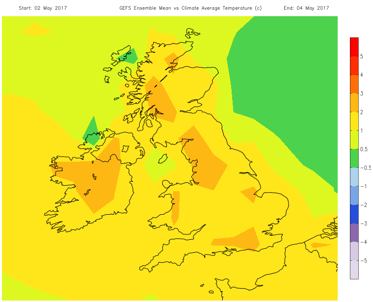
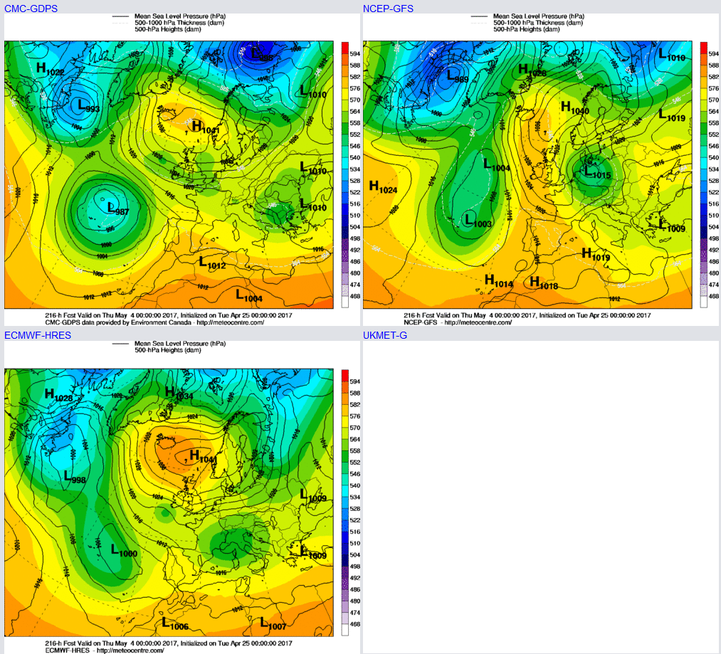
Looking further ahead into early May and there is some scope for optimism if you’re after an increasing in temperatures at least. While the broader synoptic evolution does have some uncertainty about it, what has been quite a consistent signal from the models (including that of the 00Z model suite) is the development of higher pressure across NW Europe as the opening week of May progresses. Depending on the exact evolution of the high pressure then there is the potential, at least, for much warmer conditions in association with a possible S or SE’ly air mass. Apparently after the late April cold then any increase in temperatures to near early May averages will lead to warmer weather anyway. This signal for blocking patterns to return is highlighted well by the ECMWF, GFS and GEM at 216hrs, with ENS support too.
The GEFS ENS v a Climate Average Temperature for the period between the 2nd and the 4th of May also highlights this potential warming trend too. Temperatures, currently at least, may well become 2C to 3C above average which would equate to likely maximum temperatures between 15C and 20C as a general guide.