The next few days are going to feel cold with a brisk north wind bringing sharp showers and the risk of sleet and hill snow. Winter coats at the ready.
It's going to feel colder this week. A cold front is already moving southwards through the UK bringing a band of cloud and rain over northern England and Northern Ireland. Ahead of this, there is a fair amount of cloud over England and Wales, with some bright spells but also light patchy rain from the remnants of a warm front. Depending on the cloud cover, temperatures varied from zero, with a frost, to a milder 8 or 9C with grey skies at the start of Monday.
Behind the cold front over northern Britain, there are clearer skies and the cold air. Caught in the north wind are lines of showers, some already over northern Scotland. These will bring the wintriness; sleet, hail, rain and snow.
Today
The cold front will take until tonight to clear through the south coast of England. During today, the band of cloud and rain will nudge southwards. The rain will be quite showery and temperatures should still reach 14 or 15C for southern England and not feel too bad if you get a brighter spell. The light west winds will pick up during the day, veering to the NW.
By this afternoon, there will be more chance of rain over SE England but brighter skies and sunshine for north Wales and northern England. These brighter skies accompany the colder air, so don’t be fooled by how it looks. There will be a strong NW wind through the Irish Sea by then with a chilly afternoon for Northern Ireland. Temperatures around 6 or 7C with a brisk north wind and blustery showers with a hint of sleet.
As little circulations form in the flow, they will bring wintry conditions across northern Britain today. Up over the mountain tops there will be 20cm possible for the peaks but for the major high level routes several cms are expected and a slight covering at lower levels. At times, there will be whirling snowflakes and a covering on the ground but the sun is strong at this time of year and will have warmed the dark tarmac of the roads. So, the wintry scene will come along with ominous skies and then pass as the sunshine returns.

The yellow warning for snow from the Met Office was 0400-1100, it has now been extended until 1500 as the main snow/sleet area moves across Grampian this afternoon. Winds here will not be an issue as it’s at the centre of a circulation but for northern and western Scotland there will be strong winds with gales along the west coast in the NW then north winds.
Tonight
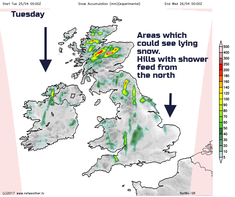
In a northerly flow, there are certain areas of the UK which will be prone to showers and so the risk of sleet and snow this time and others which will remain more sheltered. Northern Scotland always is always likely with Northern Ireland, NW England and north and west Wales overnight in the NW winds. Clusters of showers could reach through Wales onto the moors of SW England. Temperatures will fall below freezing for many inland and there will be a sharp frost. As the winds turn more northerly through the night then eastern Scotland and NE EGNland through the Pennines see more showers. Also, snow for the North York moors with sleety flurries possible into East Anglia by Tuesday
Tuesday
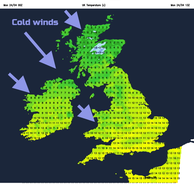
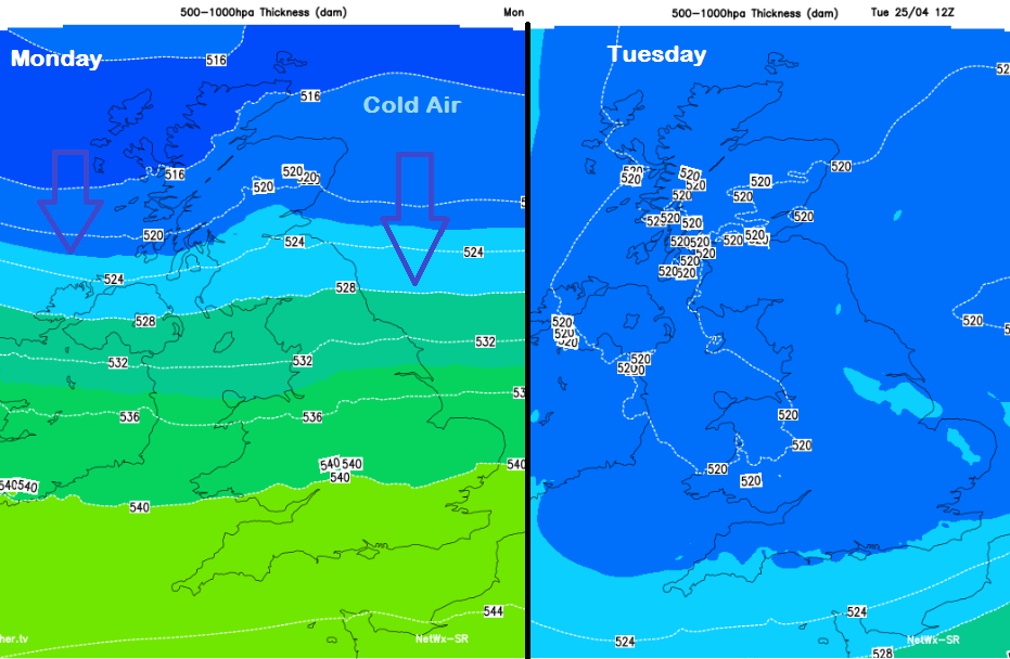
Tomorrow everywhere will be feeling the cold air. The north wind will freshen and make the day feel cold. The Arctic air will be across all parts as you can see from the blue colours on the Thickness chart above. There will be fine, dry and sunny weather to start the day for inland central Britain and in the south. However, lines of showers with darkening skies move down in the cold air and bring a sting of icy rain to lower levels, flurries for northern Britain and again snow over the hills, with a covering for the mountains. The top temperatures will be 10 or 11C for SE England and a few spots to the lee/south of high ground. The showers become more widespread during the day with the risk of hail and thunder. It will be a true April day with sunny spells and then sharp downpours, but with a wintry twist this late in the month.
Rest of the week
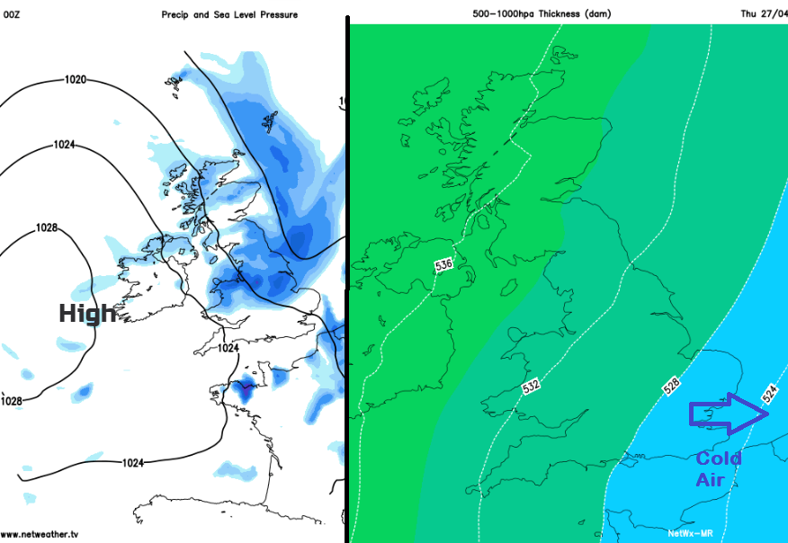
HIgh pressure out in the Altantic has made up part of the synoptic pattern resulting in the cold north flow. This high will begin to build over the UK later in the week. The flow then turns more westerly and so won't be as cold. The weather remains quite mixed with more showers especially for eastern Britain, western areas dry up a bit slowly. The winds ease off as well towards Friday, so that will make it feel less chilly too.