
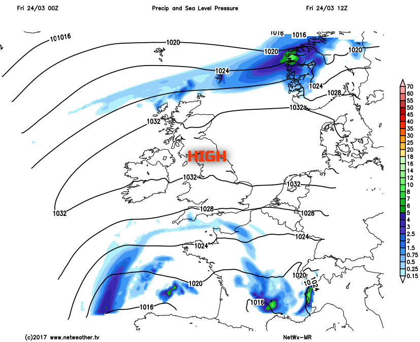
High pressure building over the UK brings a change in our weather this weekend, settling things down and bringing some pleasantly warm spring sunshine for many.
Some parts of the UK, particularly N England, have experienced some prolonged spells of rain of late with some large rainfall totals, while snow was a disruptive feature only a few days ago across parts of the north. But high pressure is now building across the UK, and this will signal a very pleasant and welcomed period of dry conditions, along with plenty of sunshine and rising temperatures this weekend.
That being said, some further cold nights are possible beneath the high pressure this weekend and Friday starts chilly. Minimum temperatures have fallen to -4C at Glasgow, -3C in Edinburgh, -1C at Prestwick and widely near to freezing across many other rural areas, which has led to a chilly start on Friday with a ground frost at least. There are still some residual unsettled conditions, especially across parts of Devon and Cornwall, where overnight patchy rain remains in evidence, but this will clear as the day progresses. Through the rest of Friday and emphasis is on a lot of broken cloud and spring sunshine, especially across parts of S Scotland, Ireland, N England, N Wales and eastern areas of England.
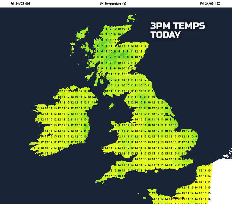
Temperatures through the course of Friday afternoon will respond to the increasing amounts of sunshine, and many areas will see temperatures back up to nearer average, if not slightly above average across some inland areas of England and Wales. There will, however, be a continued cool E’ly breeze across some southern areas, and more eastern coastal counties of England will also be cooler. That being said in the sunshine this afternoon and with temperatures around 8C to 13C, generally, then it will feel very pleasant, especially than compared with of late.
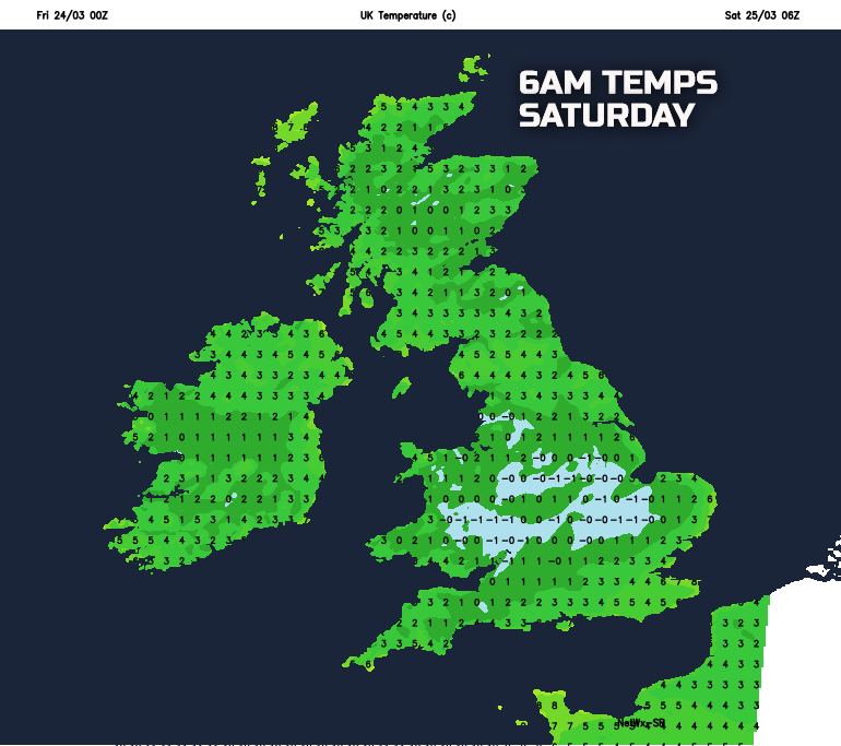
Sunny spells this evening will, for many areas, be replaced by clear spells into the overnight period which will allow for another chilly night. Cloud will be thicker across the far north of Scotland, perhaps across Cornwall too. However, the emphasis is on most of the British Isles having a dry night with some prolonged clear spells, leading to a risk of a slight frost, along with some mist and fog patches too.
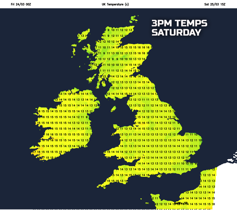
So, the weekend starts dry across many areas of the UK as the high pressure dominates the weather. While a chilly start is to be expected there will be plenty of spring sunshine during the morning and this, for many areas of the UK, will continue throughout the course of Saturday in what will be a very pleasant spring day indeed. When this is combined with light winds and the increasingly ‘strong’ late March sunshine, then temperatures will rise a degree or so when compared with Friday, and it will be a pleasantly warm afternoon for many inland areas of the UK in particular. Temperatures will widely rise to 10C to 14C, but locally 15C or 16C is likely, very respectable temperatures after the colder and more unsettled conditions of late.
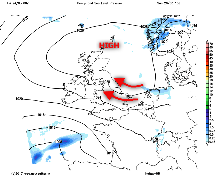
Another cool night will then follow on Saturday night into Sunday, again primarily because after sunset skies will remain clear by night and when coupled with further light winds will allow temperatures to fall away quite quickly. As a result, another slight frost is expected on Saturday night across many inland areas of the British Isles, along with some mist and fog patches as well. However, this means that Sunday once again starts dry across many parts with some bright or sunny spells. There will, however, be some subtle differences in the weather, and that is due to the location of the high pressure by this time. As Sunday progresses, the high pressure will begin to drift northwards with the main centre of the high becoming located across parts of Scotland and the North Sea, as highlighted on the below weather chart.
This will allow more of an east or south-easterly breeze to develop across England and Wales in particular and, of which, is likely to signal more cloud arriving from the east during the day. The cloud then, eventually, perhaps thick enough for some patchy light rain or drizzle across eastern coastal counties of England later in the day. So, while most of Sunday will still be another pleasant spring day across many areas, it will, overall, be a slightly cooler day than compared with Saturday and with more in the way of cloud around too, especially across more eastern areas.
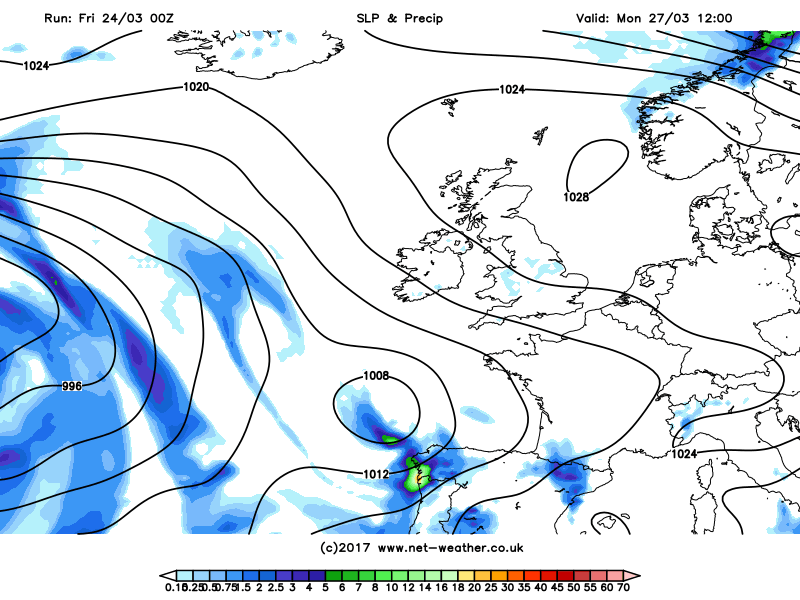
A quick look into next week and the high pressure is expected to maintain some mainly dry conditions for most of the UK into the start of the week. However, there is increasing confidence for the high pressure to decline as the week progresses and with lower pressure becoming more influential from the west and south-west. This may well introduce a warm SW’ly air mass, so there is little sign of any colder weather returning. However, if you were hoping this fine and settled spell would last, then, unfortunately, it doesn’t look like it will as the low pressure brings increasingly unsettled conditions, especially across the north and west, as shown in the animation below.


.jpg?w=350)

