


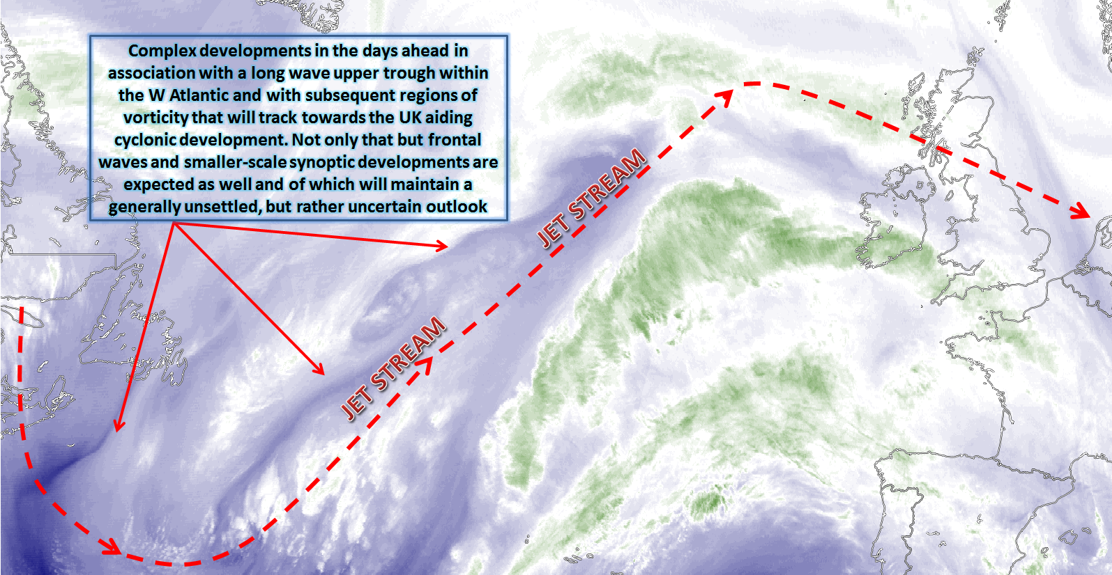
Some real uncertainty with regards to the details over the next 7 days, as Matt highlights in his latest synoptic guidance blog.
Issued at 1500GMT on Tuesday 7th Mar based on 7th Mar 00Z Model Runs
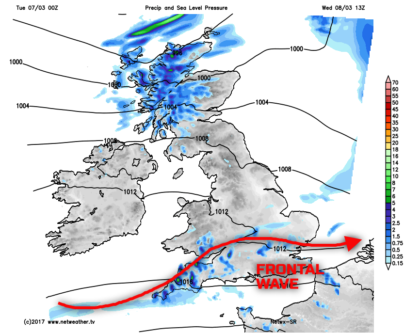
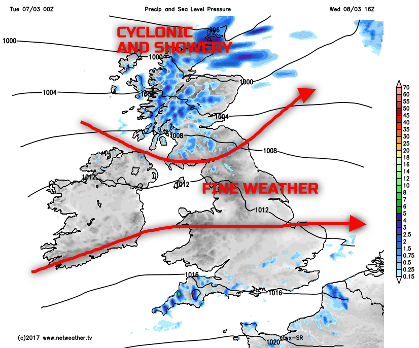
Wed 8th Mar: We move into Wednesday and model agreement is good for an area of low pressure to be passing to the NW of the UK, in association with a 190KT jet streak moving across the UK from the SW. The main GM’s (UKMO, GFS, GEM and the UKMO) are all in good agreement regarding this broader synoptic development, and clearly, the weather across the UK will be of a cyclonic nature through the course of the day. The frontal zones associated with the low pressure passing to the NW will be clearing away to the E of the UK through the course of Wednesday morning after bringing frontal rain and drizzle to many areas on Tuesday night. The frontal zones will be well forced, and there will also be an element of orographic enhancement too, so it is across more northern and western areas of the UK that some of the largest rainfall totals will have occurred into early Wednesday. As Wednesday progresses and three different weather zones will develop across the UK in what will already be quite a complex synoptic evolution. The first feature of interest is the development of a frontal wave, originating from the cold front that will be clearing away to the E of the UK early in the day. HRES model data does a better job at picking out the finer details of this development. However, it would seem that a zone of frontal cloud and precipitation will plague many central and especially southern areas of England and Wales throughout Wednesday with outbreaks of rain and drizzle at times before eventually easing towards the end of the day.
The best of the conditions will be from more central areas of the UK, so across parts of N Ireland and eastwards into more southern areas of Scotland and particularly so across N England. Subsidence is likely to aid in breaking up cloud amounts across this region and leading to some fairly widespread sunny spells during the day. More central and northern areas of Scotland though will be more unsettled, and this is the third region of weather during the day. Low pressure is expected to pass to the north of Scotland during the day, and this will produce a more convective, showery regime here through the day along with a fresh or strong W or NW’ly wind. Some of the showers could be heavy; forecast atmospheric soundings do support TCu or CB development. The other areas of weather are highlighted well on our HRES model through Wednesday afternoon.
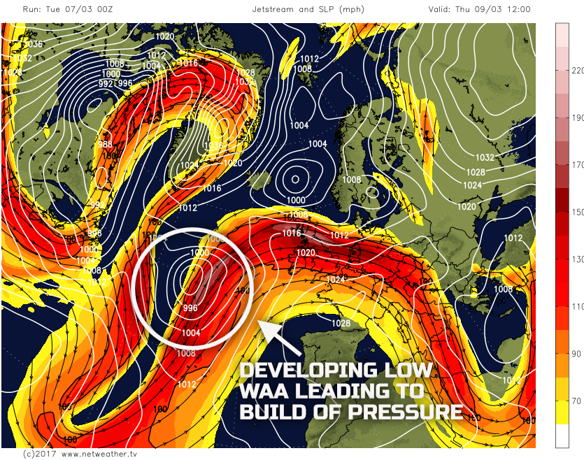
Thu 9th Mar: Into Thursday and the pattern across the N Atlantic begins to become increasingly amplified and also particularly complex. At the moment though the UKMO, ECMWF, GFS and the GEM are all in reasonable agreement for a long wave upper trough to be in evidence to the W and SW of the UK and within this upper trough cyclogenesis is expected to take place. Advancing frontal zones are, as a result, forecast to approach the UK from the SW through the course of the day, the timing of which is uncertain. However, warm air advection (WAA) on the forward side of the approaching low pressure will signal a subtle rise in pressure across the UK and, as a result, most areas of the UK may well have a reasonable day on Thursday ahead of frontal cloud and rain or drizzle from the SW later. Low pressure tracking to the E and NE of the UK may still maintain enough instability across Scotland for some showers, but even these should ease as the day progresses and the emphasis is for a ‘window’ of drier weather for most with some bright or sunny spells.
Given quite a mild air mass in place over the UK then a fairly Spring-like day is expected across many areas. The GFS model highlights the particularly amplified pattern across the N Atlantic, and the area of low pressure is highlighted. Note the rise in pressure with atmospheric pressure near or passing 1020mb across England and Wales in particular, with more of an anticyclonic flow across the UK, once the low pressure to the N of Scotland clears away.
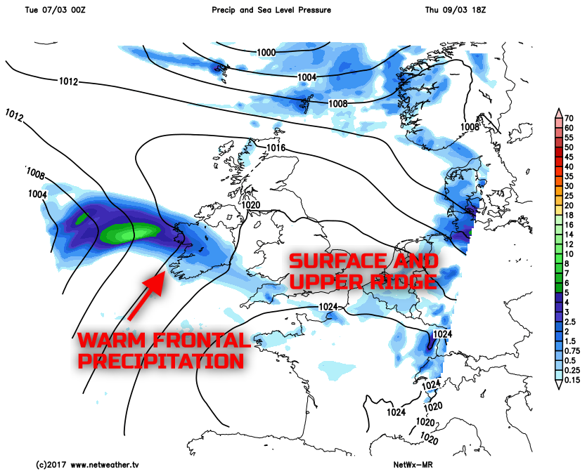
Frontal cloud and precipitation will likely and eventually move into Ireland, Wales, and SW England later in the day and overnight, but for most of the UK, a mainly dry day is likely. What should be highlighted as well is that this particular frontal zone was, only 48hrs or so ago, set to move across the UK far more quickly during the day It is this finer detail that is creating a lot of uncertainty in the forecast in the coming days with further potential for short-range details to change. Our medium range weather model though does highlight warm frontal precipitation is moving into some S and SW areas later on Thursday.
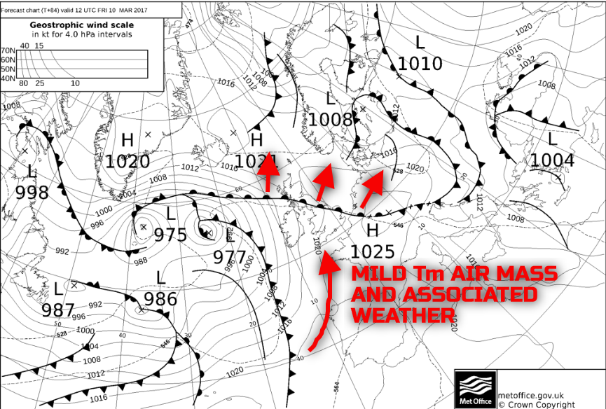
Fri 10th Mar: As we move into Friday and the broader model agreement is good. Low pressure and a particularly cyclonic pattern will dominate within the N Atlantic, while a ridge of high pressure, along with a surface high over France, will be in evidence across most of England and Wales in particular. However, the warm front will have continued to move northwards across most areas overnight and through into Friday, as things stand. As a result forecast soundings show extensive low-level cloud across the UK in association with a, particularly mild Tm air mass. The UKMO FAX highlights this general evolution for Friday well, note the continued NE progression of the warm front, while cyclonic features dominate to the W, but with a particularly mild and moist SW’ly air mass over the UK.
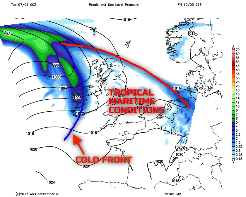
So, after the reasonable Spring day on Thursday, many areas of the UK on Friday will have particularly poor boundary layer conditions with the extensive Sc-type cloud, along with some extensive low cloud and hill fog as well across many western hills of the UK. Various regions of light rain and drizzle are possible too, perhaps WAA driven and with some evidence or orographic enhancement, so parts of Wales, SW England, NW England, SW Scotland, for example, seeing the greatest risk of some light rain and drizzle through the day. The cold front on the UKMO FAX, to the W of UK, is, however, expected to move into Ireland later in the day and this will bring more in the way of organised and heavier precipitation here. This signals the onset of more widespread unsettled conditions moving across the UK into next week in association with an upper trough. The cold front, though, is marked well on our medium range model for late Friday.
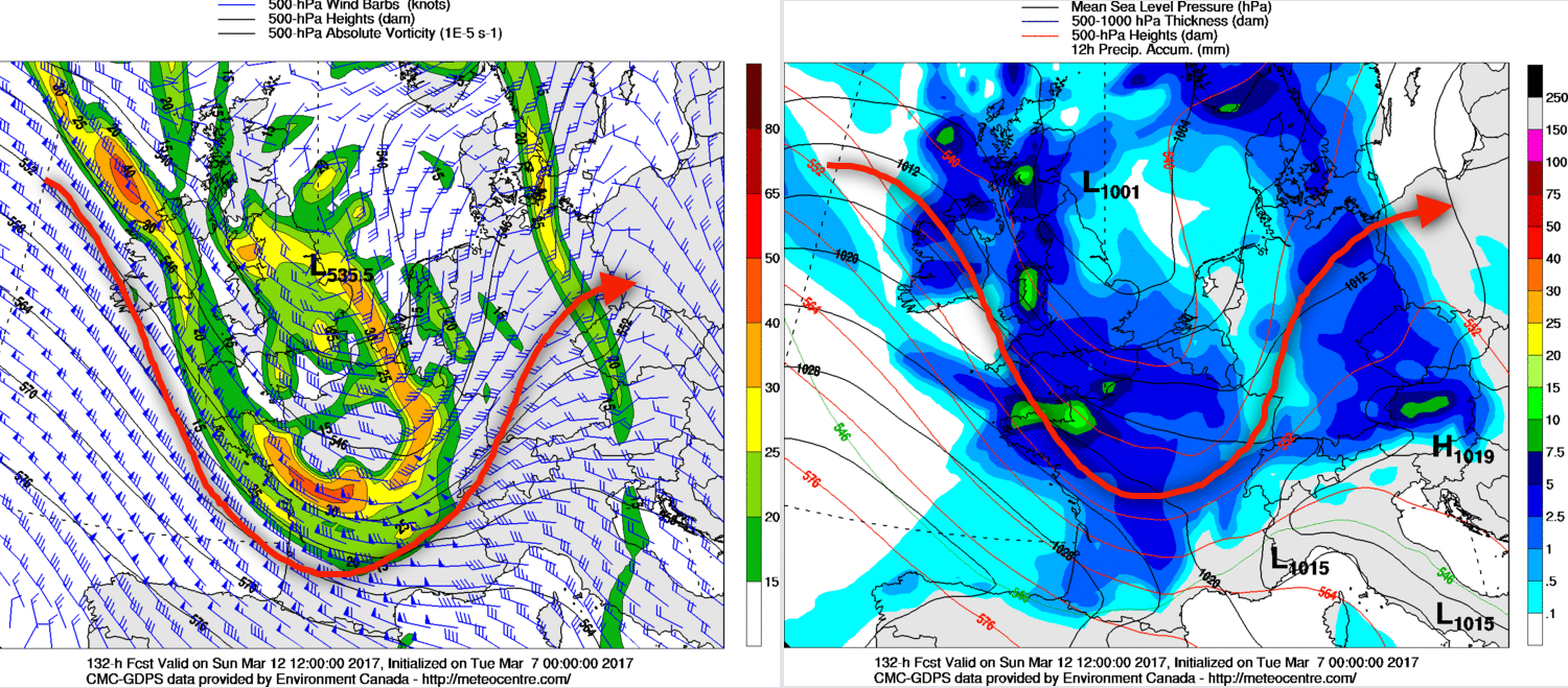
Sat 11th and Sun 12th: We move into the coming weekend with further changeable but often cyclonic conditions dominating across the UK. As was indicated at the start of the discussion there is, however, considerable uncertainties over the details of the weather for the weekend. That said there is evidence of two short-wave upper troughs that will move across the UK over the weekend. The first upper trough is expected to be associated with the cold front that will be moving into western areas of the UK later on Friday. The upper trough is then expected to track eastwards on Saturday to bring some rain and showers, perhaps during the early part of the day in particular, while something drier then follows into the west. This first feature is highlighted on the below from the GFS model as an example.
After a temporary and minor ridge of high pressure follows from the west later on Saturday, too, again, bringing somewhat drier from the west late on Saturday, a more pronounced region of low pressure and associated upper trough will then move across the UK during Sunday. The timing of this particular feature is uncertain. However, at the moment at least, is likely to move across the UK during daylight hours on Sunday to bring some heavy showers too perhaps given that convective development is becoming more of an influence on the weather now in conjunction with the increasingly ‘strong’ March sunshine. There are variations regarding the shape of the trough and again the timing of it. Using the GEM model, as an example, which is one of the preferred solutions, for now, you can clearly see a marked upper (diffluent) trough moves across the UK in association with a surface low (1001mb) through the course of the day bringing unsettled conditions.
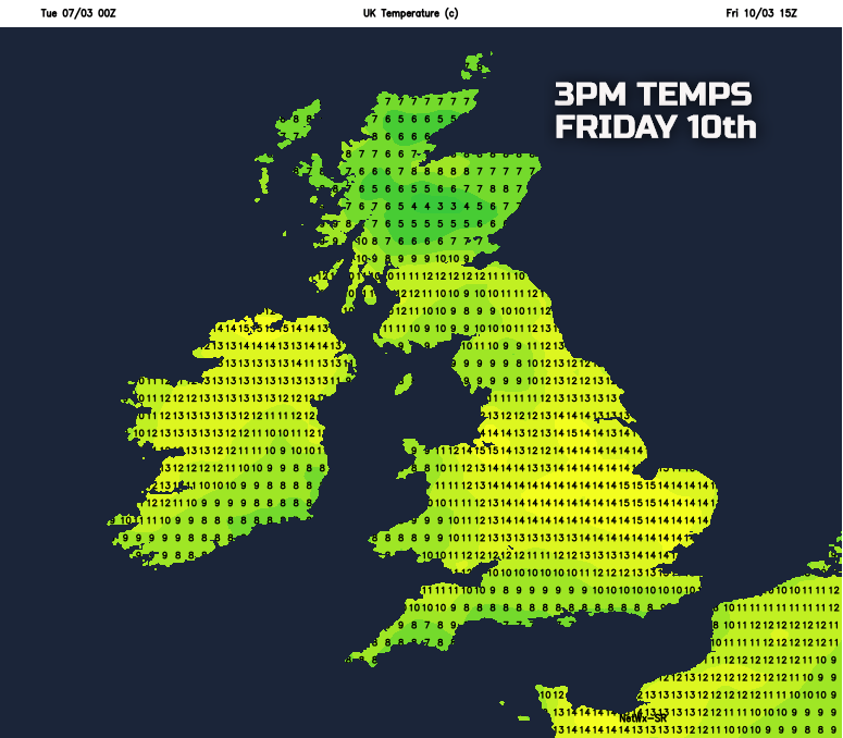
Temperatures in the coming days will be on the rise. As previous discussed Tm air masses will come into play through the rest of the week behind the warm front moving northwards on Thursday and into Friday, so quite a mild or very mild period of weather lies ahead. Temperatures may cool somewhat into the weekend as the flow veers more towards the W, but even then average temperatures are still preferred. With quite mild conditions across the UK then when combined with any sunshine will make for some particularly Spring-like conditions at times. Using our medium range model as a guide and example, you can see on Friday afternoon some areas of England and Wales may see temperatures up to 14C or 15C, Spring-like and considerably above average.
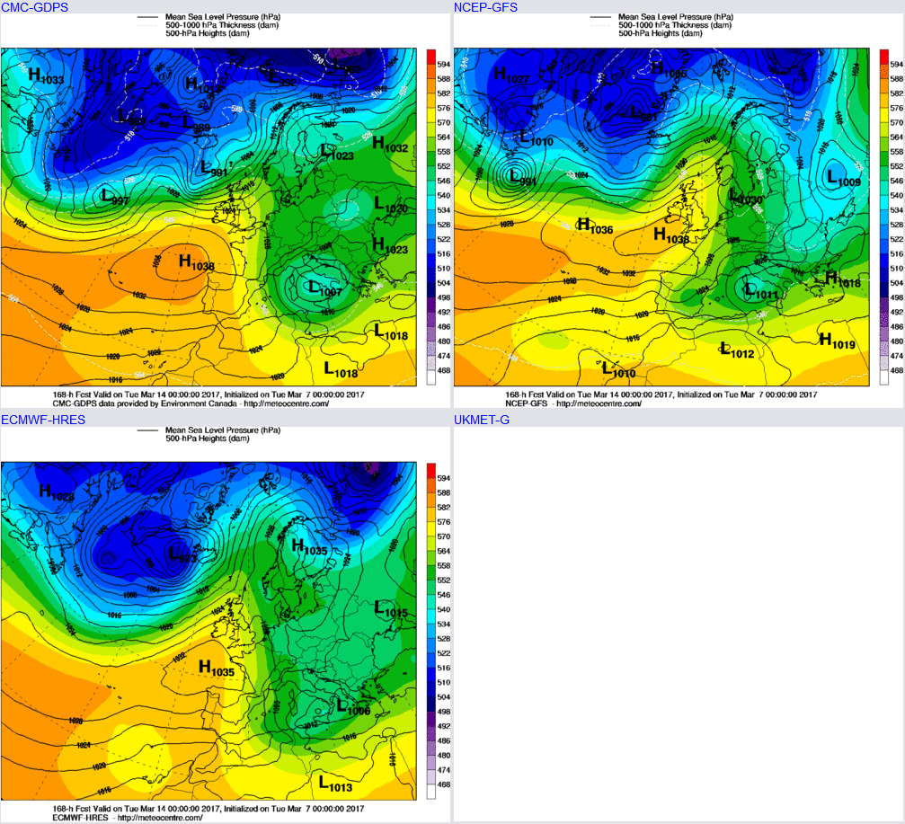
Looking further ahead towards and beyond the middle of the month and the thoughts this week are dominated by uncertainty, unfortunately. There have been some global drivers that could have influenced conditions across the N Atlantic in the last week or so, but haven’t done, including the likes of the MJO for example. Equally the protracted SSW towards the end of February turned out to be yet another ‘watered down affair,' something which happened a couple of times through the winter. March is often a month of conflicting extremes as we change seasons and that doesn’t help either. However, looking at the longer term there is likely to be a rise in pressure early next week behind Sunday’s unsettled conditions, so more in the way of settled conditions are expected as we move into next week, this highlighted well by the main 00Z GM’s for Tuesday 14th.
However, that upper pattern isn’t a stable one so any rise in GPH early next week may well be short-lived with further changeable conditions returning. There is some evidence that the MJO, which is currently in phase 3 and perhaps moving into phase 4 could bring more in the way of a +ve NAO regime, but even that is a tenuous link. As a result, the second half of March is particularly uncertain with almost an equal chance of anticyclonic or cyclonic conditions prevailing and further model runs in the coming days and weeks are required to determine how the rest of March may pan out this year.


