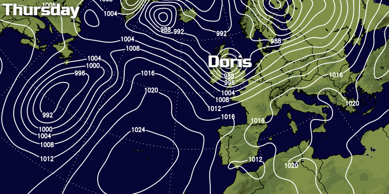
Storm Doris is developing as we speak and will be bringing a spell of treacherous weather overnight and during tomorrow, with severe gales, heavy rain and snow all included.
Storm 'Doris' the fourth named storm of the winter will arrive overnight, in a 'topsy turvy' situation at the moment that'll last into the weekend. 'Doris' a deepening depression crossing the country tomorrow morning has already prompted amber warnings of severe damaging gales especially across parts of northern England and The Midlands and of snow in the North, so check if you need to travel.
For today though it's a cloudy but very mild morning from the Midlands southward, with a weak front across central parts giving a wet start over North Wales and patchy rain across the Midlands and South West. Elsewhere it's mainly dry and cloudy, and it'll remain this way through the day, apart from a little rain or drizzle in places, with the front moving a small distance further South before returning northward again ahead of the arrival of 'Doris'. Across the North, it's a little colder but brighter, with some sunshine. There'll be a few showers at first in the West, but they'll fade later, while Scotland particularly the North and East sees more widespread showers especially this morning. Some will be heavy and squally falling as snow on hills, before becoming more scattered through the afternoon.
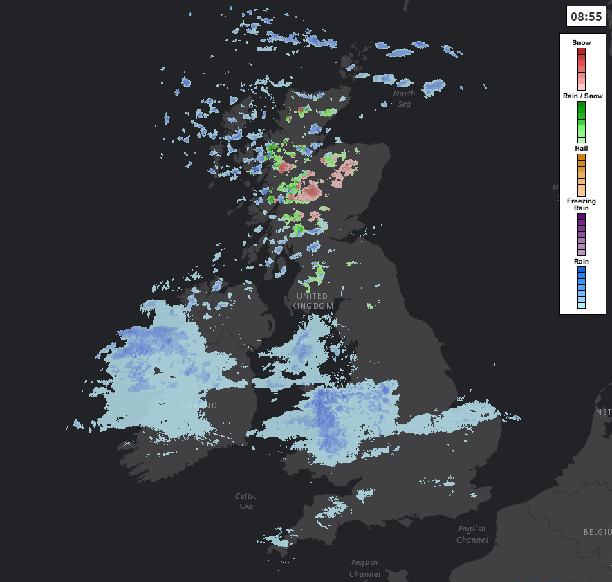
Track the latest on the live radar here.
There'll be a severe West to North West gale across North East Scotland at first, with gusts to 65mph in exposed areas, but that'll moderate towards dusk. Over Northern Ireland, lighter breezes become southerly later, with a fresh and gusty at first West wind across England and Wales. In the South, temperatures reach a very mild 11 to 13C, but it'll be a colder 6 to 8C further North with Moray and the Northern Isles struggling to reach 4 or 5C.
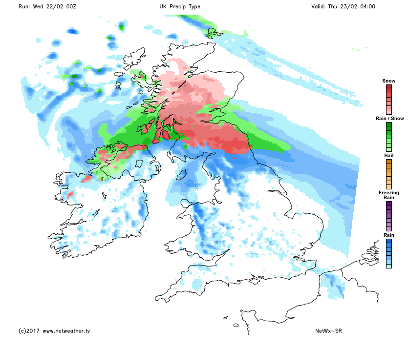
The evening brings a brief lull to much of Scotland, where any cloud breaks will result in a slight frost. During the night, though, a freshening East wind brings cloud and rain to all but Northern Scotland by dawn. There'll be snow on the Grampians and the Southern Uplands, with snow perhaps falling at lower levels bringing the risk of some disruption across Lothian, The Borders, The Central Lowlands and perhaps Dumfries.
Northern Ireland sees heavy rain moving in during the evening, followed by much colder weather and a North Westerly gale. Gusts of 60 to 70mph are possible in the North, and here too some snow is possible by dawn, mostly over the Derry and Antrim mountains. The northern Pennines, Cheviot and Cleveland hills may also see some snow by morning, while the remainder of England and Wales are much milder overnight with some rain. This'll be heavy in the North but lighter and patchy rain further South. A South West wind will freshen everywhere, though, with gale or severe gales likely in exposed areas later. Temperatures of 9 to 11C into the early hours will feel quite balmy, but it'll be much colder over Scotland and Northern Ireland later, with temperatures between -1 and +2C.
'Doris' brings stormy conditions tomorrow, with a disruptive snowfall likely during the morning over parts of central and southern Scotland and the far North East of England. This together with a severe Northerly gale and drifting snow on hills will cause travel problems.
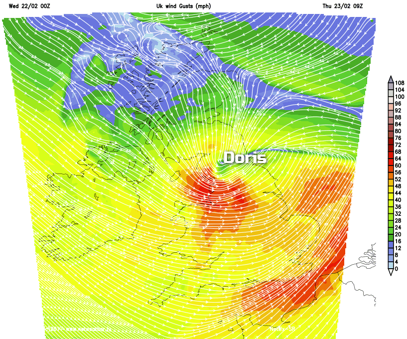
Although milder further South, West or North Westerly winds could give damaging gusts of 60 to 70mph across parts of Northern England and the Midlands before moderating towards evening. Most of England and Wales see a brief spell of rain followed mostly in the West by blustery showers that'll already have reached Northern Ireland. These could fall as snow on northern hills for a while, before somewhat quieter conditions spread to most parts overnight, although still with a scattering of showers wintry in the North.