A busy synoptic guidance blog this week.
Issued at 1500GMT on Tuesday 21st Feb based on 21st Feb 00Z Model Runs
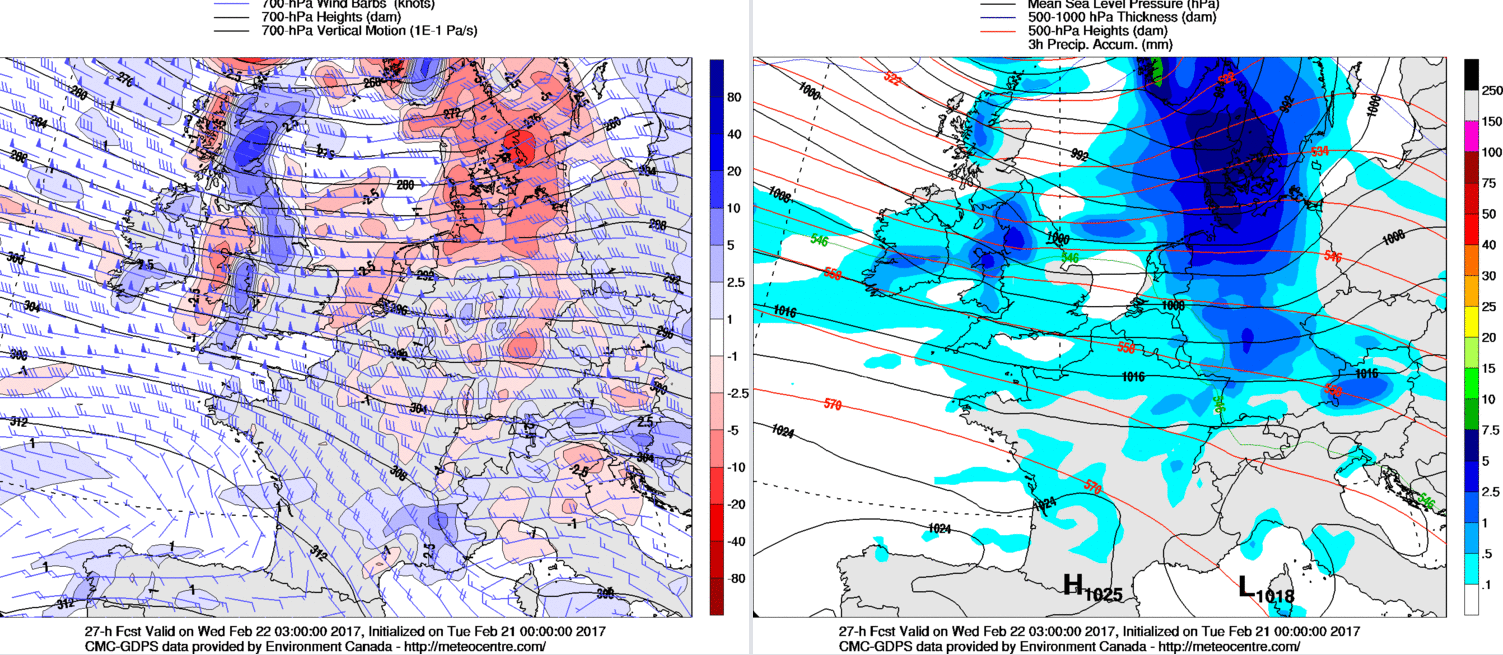
Wed 22nd Feb: Into Wednesday and there is good model agreement for an area of low pressure, quite a deep area of low pressure, to be passing to the north of Scotland during the day. It is this feature, along with associated frontal zones, that will dominate the weather across the UK during the day. The UKMO, ECMWF, GFS and GEM all have central pressure near 965mb through into Wednesday as the low passes to the north of Scotland and the PGF on its southern flank is likely to be enough to produce gales and severe gales across central and northern areas of Scotland, nothing untoward for this region of the UK, but there has been a distinct lack of stormy conditions this winter. The other noticeable feature of the weather will be rainfall totals across parts of NW England and Wales during the day. Into tonight and through into Thursday frontal zones will become quite slow moving through central areas of the UK but with some marked WAA coming into play as well then some significant orographic enhancement is expected across parts of NW England and Wales through Tuesday night and into Wednesday. Model guidance shows a lot of forcing evident within the frontal zones, as exampled below by the 00Z GEM model into Wednesday.
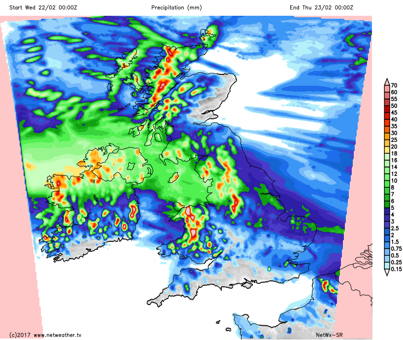
The combination of a quite an active set of frontal zones, along with some significant WAA will lead to some pronounced rainfall totals through tonight and on into Wednesday across these areas of the UK. Our HRES model data, showing rainfall totals, through to the end of Thursday, covering the 24 hour period of Wednesday clearly highlights NW England and Wales at risk of seeing locally 30mm to 40mm within that time. This is quite a noteworthy amount of rainfall within a short term after what has been a particularly dry winter so far.
For many northern areas of the UK though, so Scotland and eventually N England conditions will improve through the course of Wednesday with some drier and brighter intervals too, despite some scattered showers across Scotland and these locally wintry on higher ground, given predicted WBPT and 850’s for example. The frontal zones across NW England and Wales during the start of the day, in particular, will become slow moving across more central and southern areas of England and Wales, before then returning northwards in association with cyclonic development from the west.
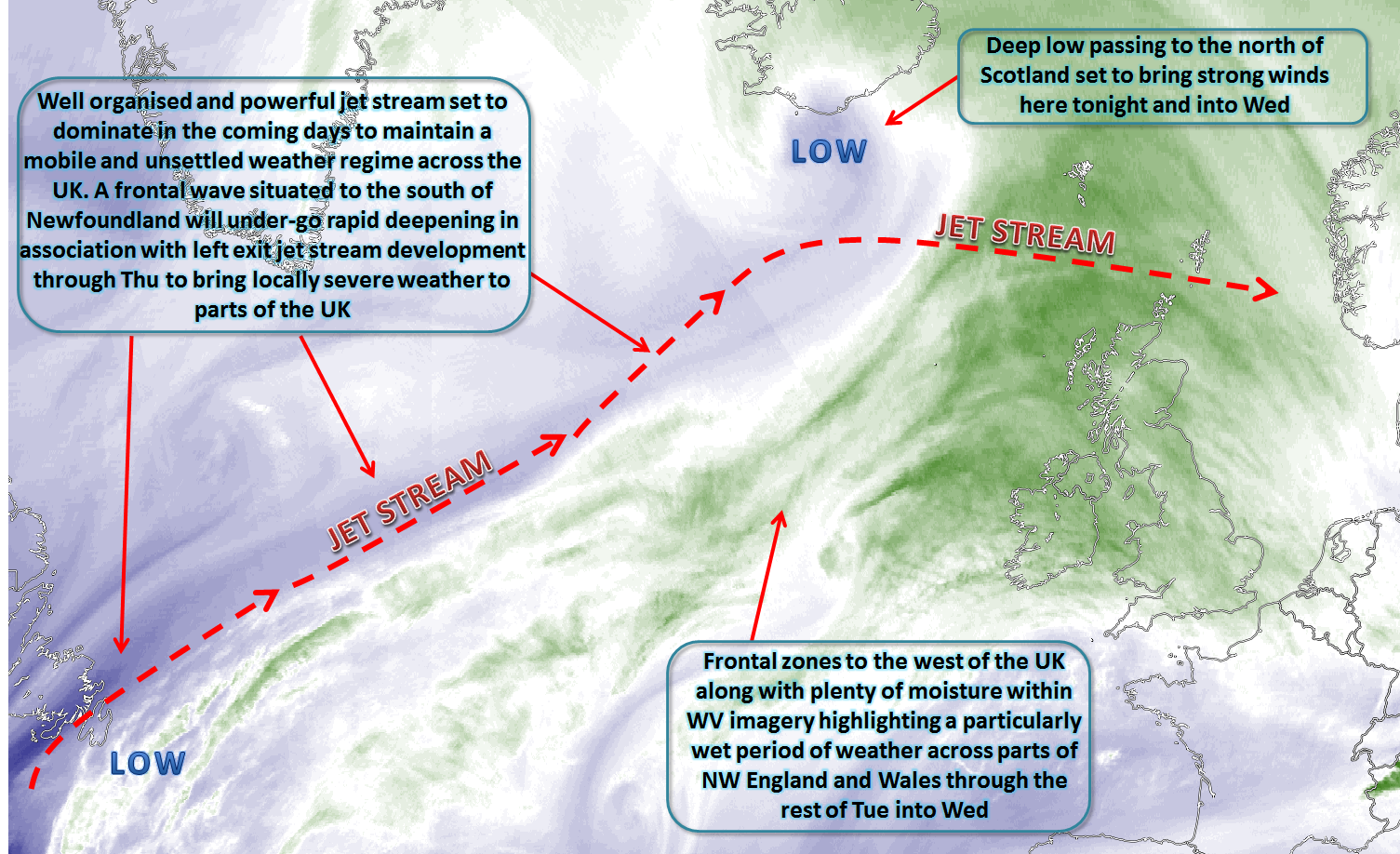
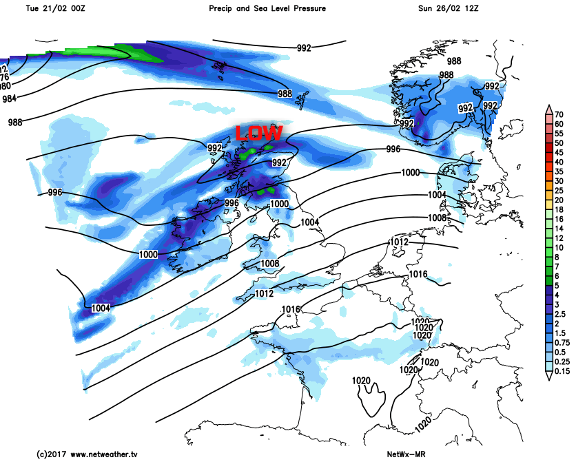
Thu 23rd Feb: Thursday is expected to be a day of disruptive weather conditions across parts of the UK. The main reason for this is the rapid development of a frontal wave from the west during the day, but the low quickly transits across the UK through the day. Model guidance regarding the development is good, but there remain some uncertainties over the exact track and depth of the low pressure which will have influences on the finer details, in terms of wind speeds, rainfall totals and also snowfall totals on the northern flank of the low pressure. The UKMO, ECMWF, GFS and GEM have the low moving into the UK from the west by 0000Z, as highlighted below in a developing phase.
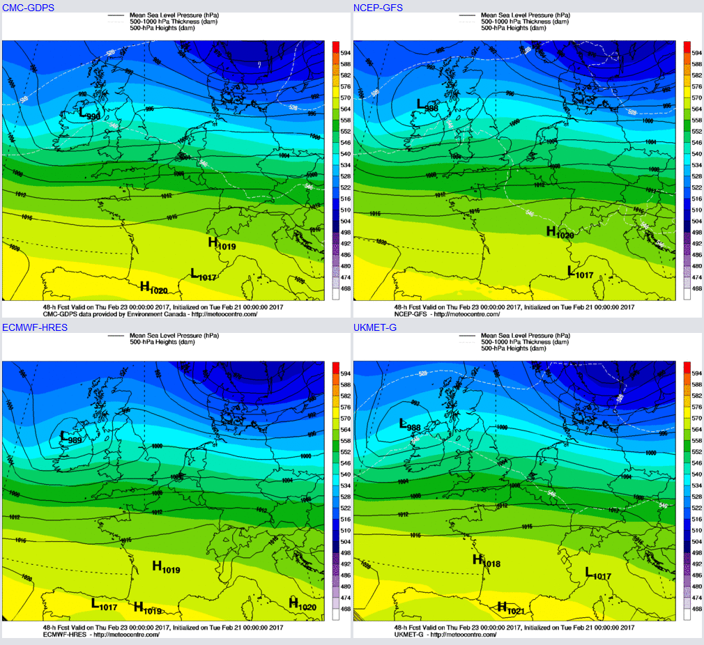
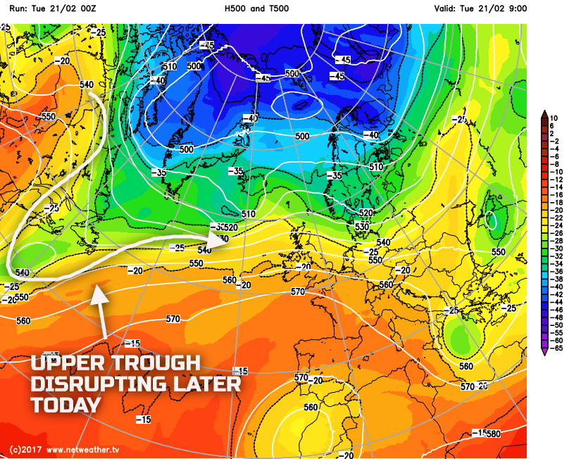
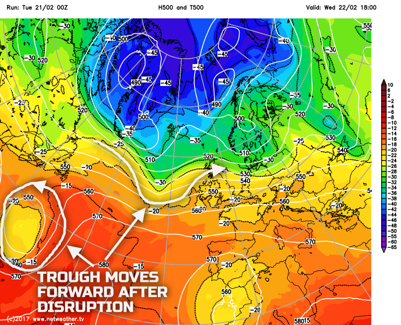
The process of development takes place due to the frontal wave, located to the south of Newfoundland at time of production and highlighted on the first forecast image, will be engaged by an upper trough that emerges from the ‘neck’ of a disrupting upper trough off E Canada and the eastern USA, which deepens the frontal wave as it crosses the UK. This is a particularly complex evolution, and it is this development that then leads on to still some uncertainties over the finer details of the weather during the course of Thursday. The disrupting upper trough and then the main upper trough that moves forward to engage the frontal wave are highlighted below.
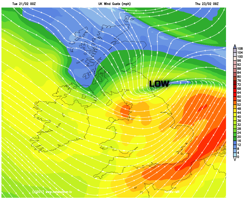
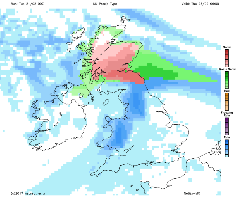
As for the actual weather Thursday will start wet and windy across many areas of the UK, but with emphasis on the greatest risk of severe weather being across parts of N Wales, N England and up into Scotland due to a combination of three variables; heavy rain, very strong winds and snowfall. So starting with the heavy rain and the precipitation from the previous 24 hours may well combine with the rainfall from this system to bring some localised flooding, but rainfall isn’t likely to be the main issue given that the system will be quite fast moving. Strong winds will be of concern given that the low pressure will be undergoing deepening as it moves across the UK and it is across N England in particular, perhaps N Wales too, that gales or severe gales are possible even inland with 60mph to 70mph gusts possible, as exampled by the MR model.
The other aspect of potentially severe weather is snow on the immediate northern flank of the low pressure. As the low pressure moves into the UK, it will be moving into a rather chilled boundary layer after quite a cold night across the north on Wednesday night into Thursday morning. Note only that, but latent heat extraction and evaporational cooling processes may also come into play given the intensity of the precipitation on the northern flank of the low pressure. As result parts of Cumbria, the far north of England and especially many southern areas of Scotland, will be at risk of seeing some locally large snowfall totals through Thursday morning, with potentially significant disruption across the Central-belt in particular. Using our MR model again as a general guidance, you can clearly see the strong signal for snow on the northern flank of the low, but the exact location of the snowfall shouldn’t be taken too literally just yet given the uncertainties over the track of the low pressure.
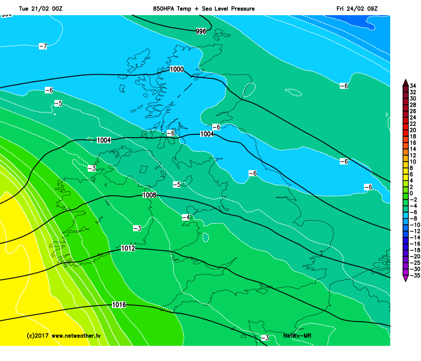
Fri 24th Feb: As we move into Friday and model agreement is good for Thursday’s low pressure to quickly clear away to the east of the UK, following in its wake though is quite a cold end to the working week given a Pm air mass, this bringing some wintry showers into parts of the north and west of the UK. However, the development jet stream across the N Atlantic will once again come into play during Friday with frontal systems and another area of low pressure approaching from the west later in the day. As a result there is high confidence for a brief ‘window’ of colder, drier and brighter weather for most during Friday, with the exception of a few wintry showers, but with then prolonged frontal rain returning from the west to affect many areas of Scotland, Ireland, N England and Wales by the evening onwards and then into the overnight period. The rain is expected to fall into quite a cold air mass, so some transient snow is possible on the leading edge of this system across the north, but WBZ and WBPT values quickly increase with rain for most. The colder air mass into Friday, from the NW, is highlighted well on our MR model, with many central and northern areas having sub -5C 850mb temps into Friday, but note the tight thermal gradient developing over Ireland, this in association with the next frontal system from the west later in the day.
The 00Z UKMO, ECMWF, GFS and GEM are all in good agreement for a deep low pressure to then track on a more climatological track towards Iceland as we end Friday and move into the weekend, but clearly the frontal systems associated with the low pressure then bringing this next batch of wet and windy weather across many areas overnight on Friday and through into the start of the weekend. The low pressure in question is highlighted.
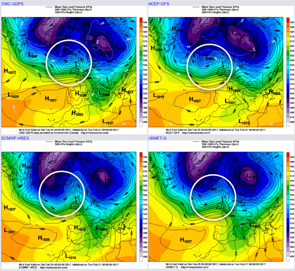
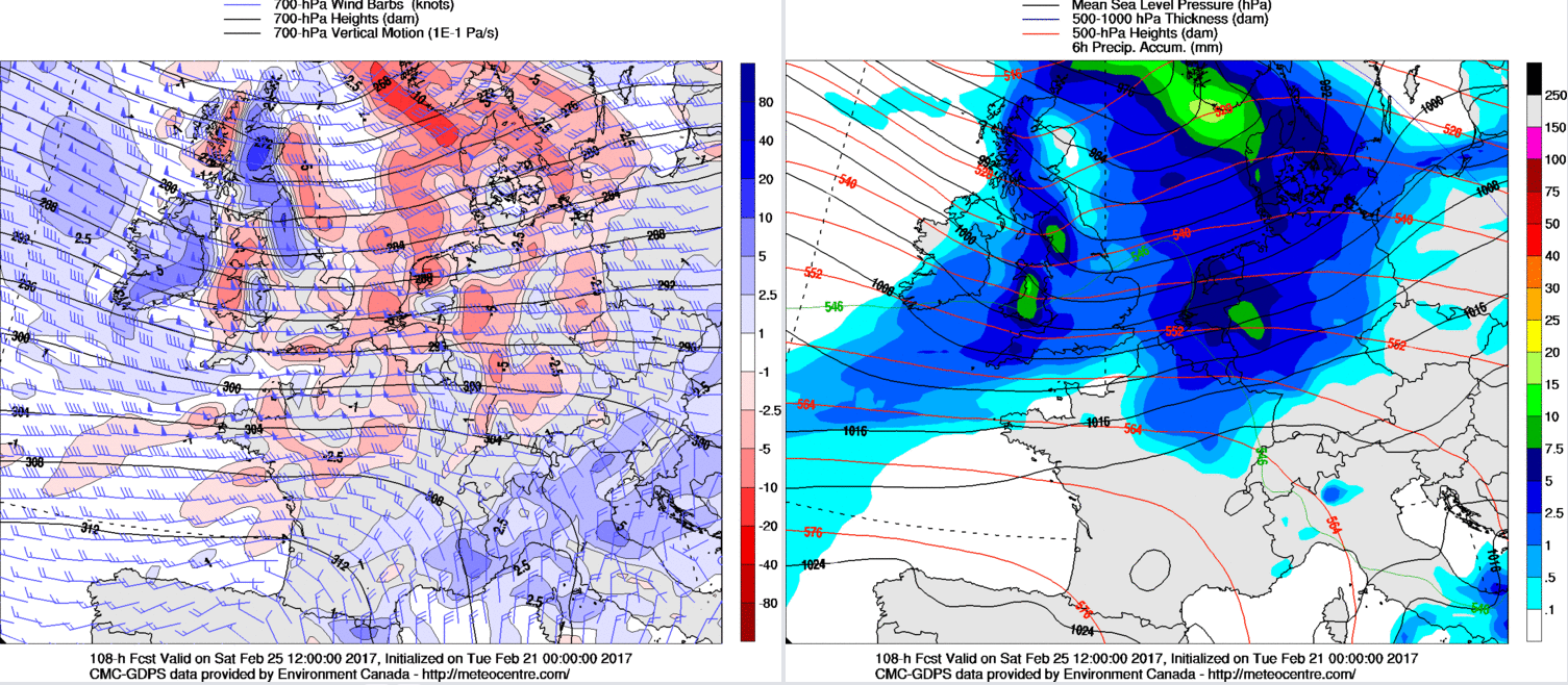
Sat 25th and Sun 26th: So we move into the coming weekend with low pressure clearly dominating the weather and whilst there are uncertainties over the details, the overall model agreement is good. As a result, quite active frontal systems will be moving eastwards through the course of Saturday to bring wet and windy conditions to many areas but with then a likely clearance from the west during the end of the day and into the overnight period. Some further heavy rainfall may well be associated with the frontal zones on Saturday, this potentially of some concern given rainfall totals from previous days across some areas of the UK. The 00Z GEM model, as an example, highlights a lot of vorticity and forcing associated with Saturday’s fronts and, again this just emphasising a particularly wet and windy period of weather during the day.
On into Sunday and yet another low pressure is set to arrive and track to the west and north-west of the UK. There is, however, considerable uncertainty over the development of this system this far ahead. Despite this, though there is relatively broad agreement within the forecast models, for further wet and windy weather to affect more northern and western areas of the UK during Sunday in particular, before potentially spreading further south and east during the rest of the day. Not to be taken too literally at this stage, but our MR model highlights the general model consensus and thinking during Sunday at the moment.
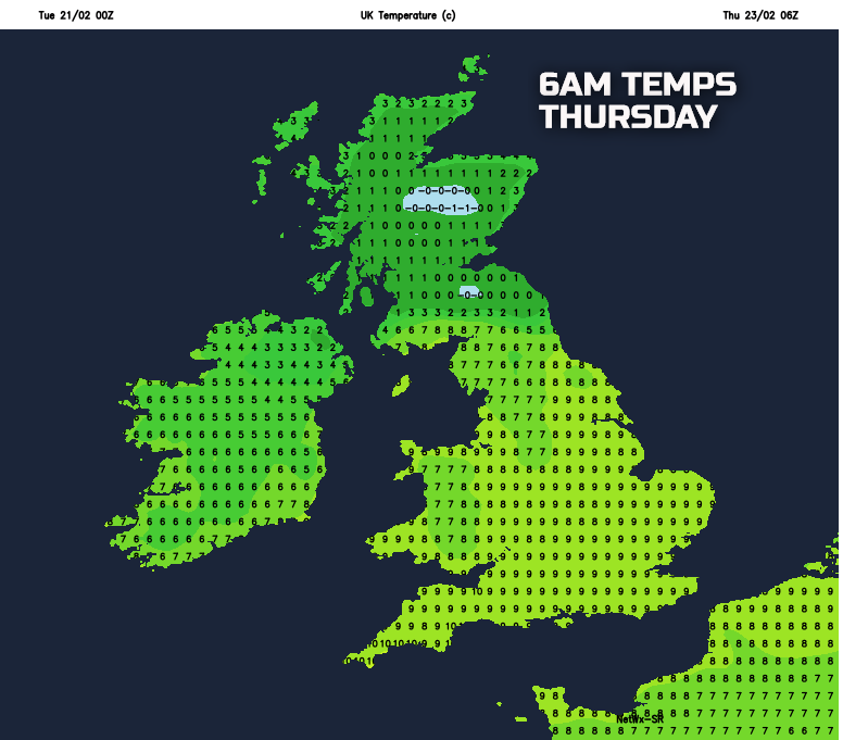
Temperatures in the coming days will fluctuate markedly and will also vary across the UK. An example of that is some further very mild conditions across southern areas of England on Wednesday, but with then colder conditions arriving from the north-west to end the week. Equally, there are likely to be some particularly impressive variations in temperatures across the UK on Thursday as the low pressure moves eastwards, with some low values beneath the snowy conditions across S Scotland, but with near double figure temperatures in the south, as an example on the below chart for early Thursday.
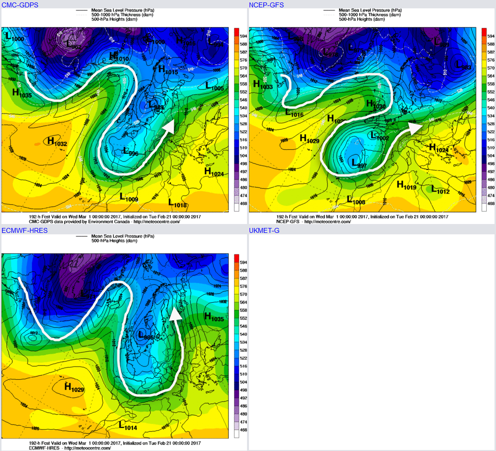
Looking forward ahead which now essentially takes us into early March and confidence is generally quite low. Despite the MJO moving into a high amplitude phase 8 around a week ago, there has been little evidence or signals within deterministic and ENS output that support a potential –ve NAO regime as a phase 8, statistically at least, can produce. However, there are some signals of a potential meridional pattern developing into early March which may lead to some colder weather from the north or north-east, as exampled below by the 00Z GFS, GEM and ECMWF, but it should be stressed that confidence in the synoptic evolution beyond 5 to 7 days at the moment is very uncertain and the early March forecast is, as a result, very uncertain too.