After the very mild Monday, it's a cooler start but southern Britain will stay mild until Thursday. Windy tonight, then watching developments for Thursday morning central swathe of Britain. Gales and snow
After our very mild start, 18.3C for Greater London on Monday, this week is going to cool down, quickly feeling colder in the north. We will see more wet and windy weather, with two bouts of gales possible in the next few days.
Rain- A wet week for NW
There will be plenty of rain for Scotland, northern England, Northern Ireland and Wales. High totals are forecast for north-western areas as the flow remains off the Atlantic, heading over Northern Ireland into western Scotland, across the Southern Uplands, Cumbrian Fells and hitting the Pennines and Welsh mountains.
Strong winds
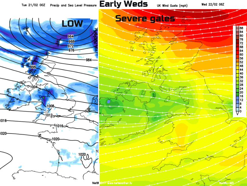
Tuesday night looks windy with severe gales thanks to a low pressure near to northern Scotland. Another area of low pressure could bring strong winds and gales across England and Wales early on Thursday, right through rush hour. Gusts of 60-70mph are possible, depending on the exact track and development of this low. One to watch for this week, along with…
Snow
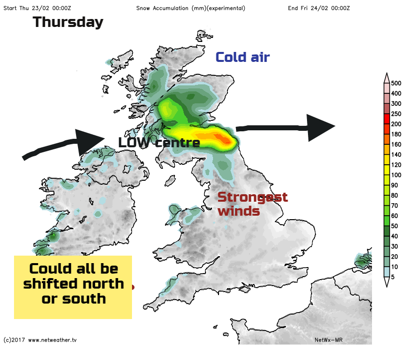
The low, which will bring strong winds early on Thursday, could bring significant snowfall to northern Britain. As the low with its wind, clouds and rain moves up against the colder air to the north, this could turn to snow. Lying snow inland with drifting snow for higher level routes is possible.*
Today
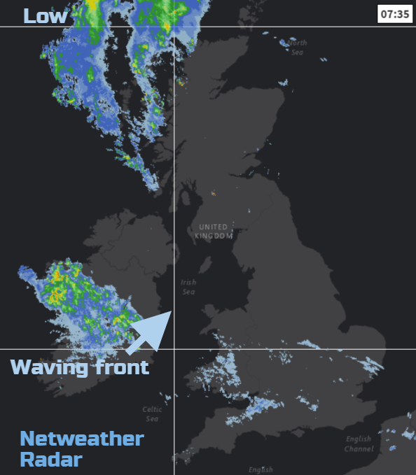
It’s still mild across southern Britain to start Tuesday with temperatures around 10C. For northern Britain and Northern Ireland, it is a cooler start around 5 or 6C. There is a lot of cloud to start the day with damp, murky conditions over SW Britain. This spreads over more of Wales and SE England, edging up from the south into Northern Ireland as the morning progresses. The light west or SW winds will begin to freshen. It will feel okay at 9 or 10C out of the wind, but not as mild as yesterday. The West County may see 13 C but the day will become blustery. The cloudy damp weather is from a waving front with will bring more persistent rain in. Western Wales and Northern Ireland will become wet this morning with the rain spilling over the Isle of Man at lunchtime into NW England and the West Midlands.
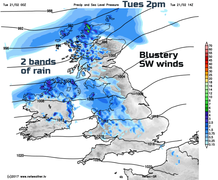
Much of the rest of Britain will have a fair start with sunny spells. Cloud does increase from the south and the west thanks to the waving front but there is also a developing low pressure close to Iceland. This is throwing frontal bands over NW Scotland and will introduce showery rain over the Highlands and Islands. The SW winds freshen and temperatures will reach 8 to 10C, Moray could see higher to the lee of the mountains. Eastern Britain will have a fine day. Temperatures will reach 10 to 14C with a moderate SW wind. It should remain dry for much of today with rain reaching across the county later this afternoon. NE Scotland will be patchy rain during the day as a warm front moves by
Tonight
Overnight, it is going to turn colder from the north and it will be windy everywhere. A rain band, the cold front will push southwards through Scotland followed by clearer skies and dipping temperatures. Also wintry showers from the NW. The frontal rain will move south through Northern Ireland and northern England towards north Wales with heavier, squally bursts overnight. Behind the front temperatures will be near to zero, with the risk of patchy ice and a cold wind. Ahead of the front still around 8 or 9C with a fresh west wind.
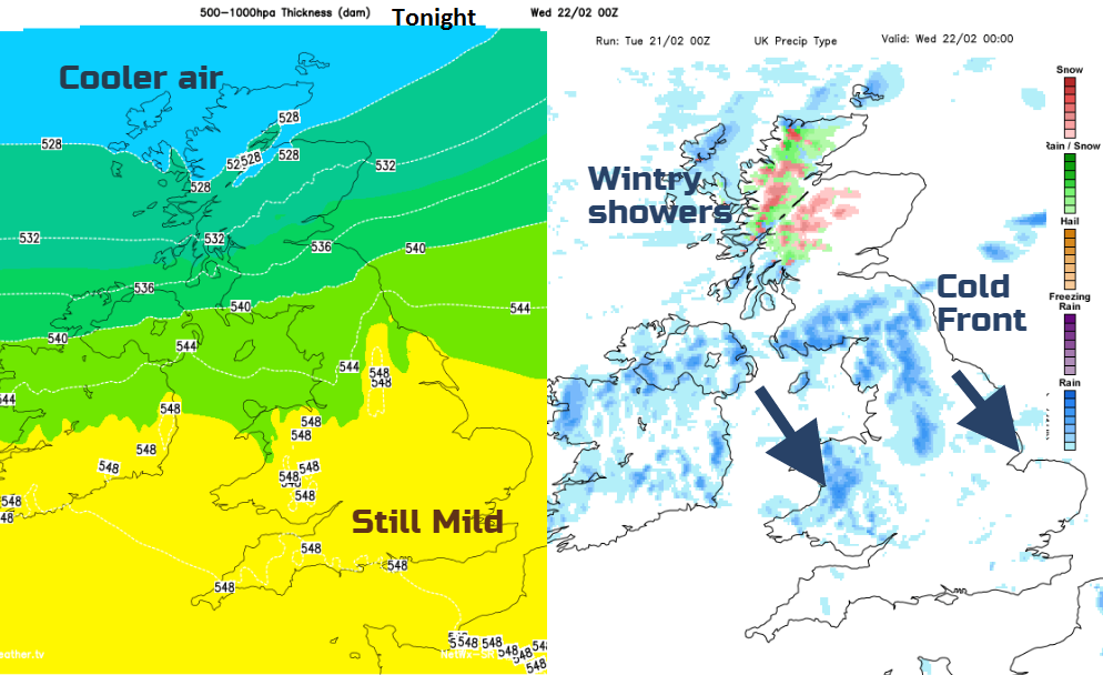
The low pressure near to Iceland will continue to deepen as it heads towards the Faeroe Islands and then Shetland tonight. It will bring a spell of very windy weather to the far north of Scotland early on Wednesday with coastal severe westerly gales likely and gusts of 65 to 75 mph
Midweek Storm?
Wednesday starts off windy with gusty conditions for NE England and Scotland. There may be disruption to the ferry service to the Northern Isles. The winds ease down and the day is mild but cloudy in the south, brighter but colder in the north. A band of rain sets in from the west later Wednesday, spilling over Northern Ireland, Wales pushing over more of Britain. This runs ahead of the developing low pressure which is causing some concerns for Thursday morning, looking at the strength of the winds and possible snowfall. * Again, how the low develops and where its path takes it across the UK will define the areas at risk from snowfall, which could be slightly north or south of the graphic below, or not deep enough over the UK for concerns. It may rapidly deepen over the North Sea and hit mainland Europe instead. We will await the next model runs.
This low pressure does have the potential to cause disruption on Thursday morning, so we will await the UK Met Office to see how the warnings develop, a yellow for snow and winds likely to be issued this morning and then if the low really does show signs of rapidly developing over the UK, it could lead to an Amber warning for impacts from severe weather and possibly the naming of long awaited Storm Doris. The naming will depend on how the forecast develops and the extent of the impacts, not the whim of a newpaper pundit. We'll keep you accurately informed here at Netweather, if in doubt ask on our Facebook page, on twitter @Netweather or join the buildup and discussion in the forum.
Into the weekend
Friday starts off cold everywhere but milder conditions will return for the weekend as more wet and windy weather sweeps in from the Atlantic on Saturday.