
A rather mild but windy day, temperatures reaching mid-teens eastern England, rain and gales across northern areas. Unsettled at times for rest of the week, gales on Thursday while turning colder.
Sunday was quite mild across the UK, with many places reaching 12-13C, with Fyvie Castle in NE Scotland reaching 14C. Today we could see temperatures reach a few degrees higher still, as a very mild air originating in the sub-tropics is steered by westerly winds across NW Europe.
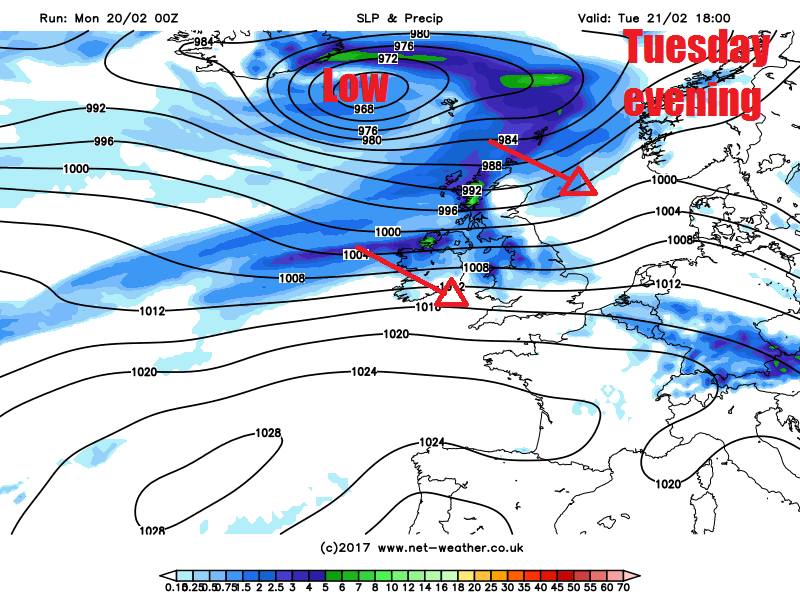
It will turn increasingly unsettled and windy across all parts for the rest of the week and temperatures will fall after today, only slightly over the next few days, but by Thursday afternoon temperatures should be back into single figures across many areas, as we see a colder northwesterly flow develop. A deepening area of low pressure crossing the UK on Thursday, ushering in the colder air as it clears, will also bring gales to England and Wales.
For now, it’s a rather mild but grey and murky start across man areas, temperatures are widely 10-12C, a few spots to the lee of high ground 13C, Capel Curig in north Wales saw 15.0C at 6am this morning. A frontal system moving west to east is bringing all the cloud this morning, the trailing cold front bringing some rain north of the central belt of Scotland, heavy and persistent across the western Highlands. It’s also rather windy across Scotland, with the westerly wind touching gale force, gusting to 50-60mph with exposure. Further south it’s drier but cloudy and breezy, though with some patchy drizzle in places, the low cloud bringing hill fog across western and southern hills and coasts.
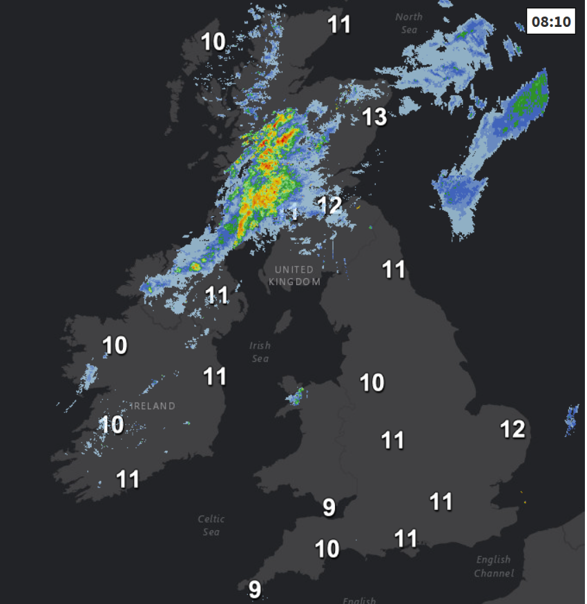
The cold front across Scotland will slip south across southern Scotland, N. Ireland, northern England and north Wales through the day, bringing a band of rain with it accompanied by a swathe of strong westerly winds which will gust to 50mph or more over hills and exposed coasts. Brighter skies following across northern Scotland, though some showers towards western coasts. South of the rain band, mostly cloudy, misty with drizzle over western hills, drier towards eastern England with some breaks in the cloud perhaps allowing some brightness or sunny spells this afternoon.
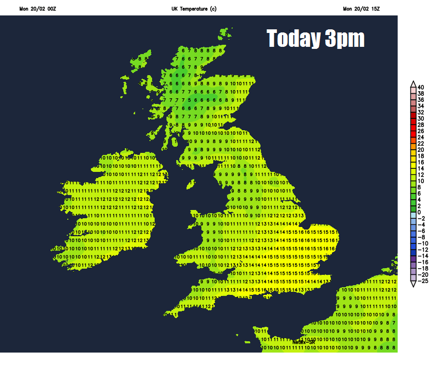
Where we see the brightness of sunny spells towards eastern England, temperatures reaching the mid-teens, perhaps as high as 16 or 17C in a few spots. Otherwise, still a rather mild 11-14C across England, Wales and N. Ireland. Cooling off across Scotland as the cold front clears south, but still a mild 8-11C.
The cold front and its thicker cloud and outbreaks of rain reaching central parts by this evening continuing to slip slowly southwards into south Wales, central and southern England overnight. Clearer skies for northern England northwards and mostly dry away from northern Scotland where further showers are likely. Mild under the cloud and rain in the south, falling no lower than 8-10C, under clear skies in the north falling to 4-6C.
Cloudy across southern and western parts of England and Wales on Tuesday, with further patchy rain or drizzle towards the west. Some brightness or sunshine at first across eastern areas of England and Scotland, but generally turning increasingly cloudy from the west, with outbreaks of heavy rain and strong winds across the northwest by evening. Another mild day, temperatures reaching 10-13C.
Band of rain and strong winds arriving across the northwest tomorrow evening spreading southeast across central parts Tuesday night. Clearer and colder conditions arriving across Scotland, with showers – which will be wintry over hills. Cloud and rain clearing southern England and south Wales on Wednesday to drier and brighter conditions from the northwest, though further showers across northern Scotland. Winds easing for a time.
Wind gusts Thursday morning
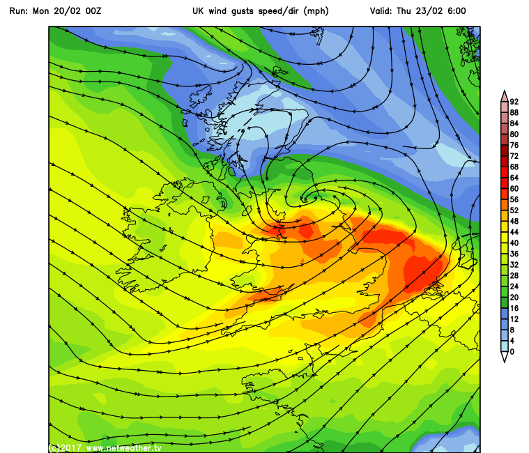
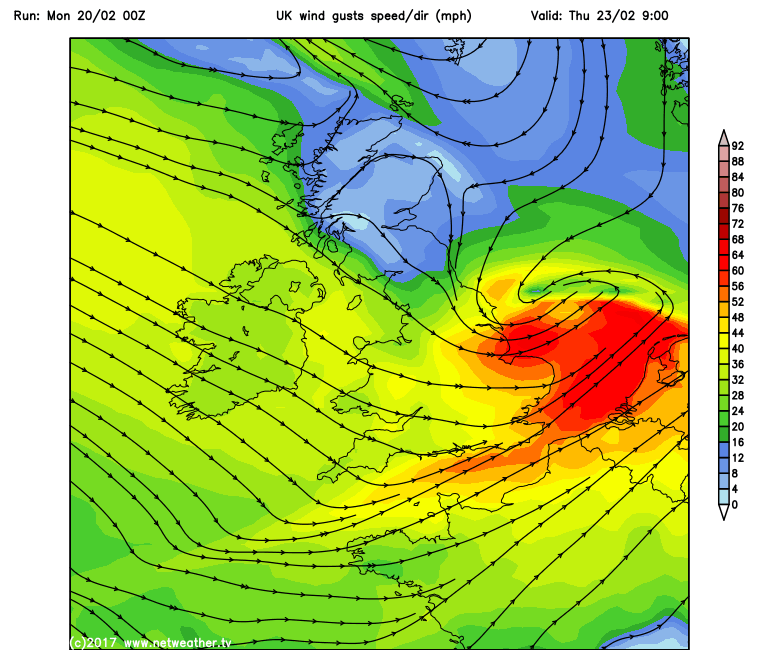
Area of low pressure moving east somewhere over northern Britain on Thursday bringing a spell of wet and windy weather across all areas, gales likely across England and Wales, heaviest rain across northern England and southern Scotland. As the low clears into the North Sea in the afternoon, a cold northwesterly flow setting in, with temperatures dropping into single figures in the afternoon but bringing clearer but showery conditions, falling as snow over northern hills. Showery at first and the chilly side on Friday in the northwesterly flow, though winds easing and turning drier in the afternoon. Wet, windy and milder conditions returning for the weekend.


