Westerly winds bringing in tropical maritime air could send temperatures as a high as 17C on Monday. But turning increasingly unsettled, windy then colder northwesterly winds on Friday with risk of hill snow in the north.
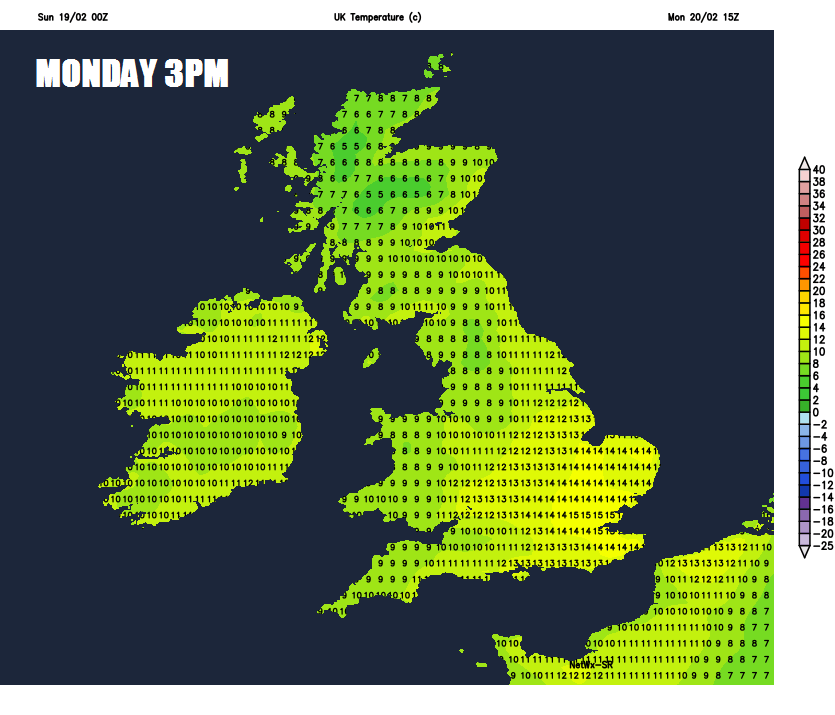
A conveyor of tropical maritime air, with origins to the west of Azores, will spread across the UK over the next few days, steered by westerly winds. So we will see unseasonably mild temperatures, peaking on Monday, when we could see highs of 17C in a few spots – particularly across eastern England.
Mild westerly flow over next few days
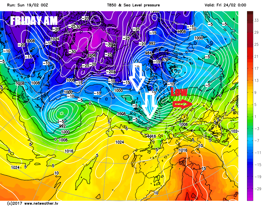
However, don’t be fooled by this early taste of spring, because the weather models indicate a potentially deep depression moving east across northern Britain late Thursday, bringing gales or severe gales and introducing a northerly or northwesterly flow which will usher in colder polar air. Friday could see highs of 4-6C at best in the north, with some snow possible too over northern hills. Nothing notable cold-wise for late February though. The colder conditions arriving at the end of the week look to be short-lived, as winds switch southwesterly by Sunday and temperatures recover back into double figures.
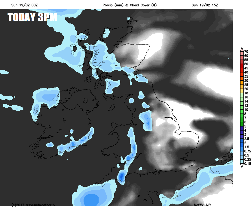
For now, weak weather fronts crossing west to east overnight have brought a lot of cloud across many areas keeping it frost free, with some showery rain across Scotland along with mist and low cloud with the odd spot of rain towards western coasts.. Clearer skies towards SE England means we have the lowest temperatures here this morning, with some mist and fog patches in places to watch out for too.
So we start Sunday on a grey, misty and murky note across many parts - with hill fog and patchy light rain or drizzle across more western areas and some fog patches towards the southeast where skies have cleared overnight. Through the morning it will be drier with some brightness developing across more eastern areas, the best of the sunshine towards SE England and East Anglia once early mist and fog clears
Generally into the afternoon to the east of high ground across eastern Scotland, NE England, Midlands, east Wales, central southern and eastern England it will be dry and bright or sunny, with blue skies towards eastern coastal areas. Low cloud across SW England, west Wales, west of the Pennines and up across western Scotland, which will bring hill fog and some patchy drizzle too. More persistent rain and strengthening winds arriving across western Scotland later today.
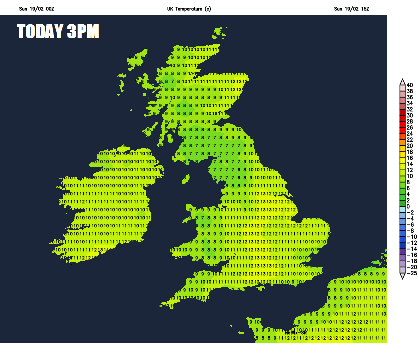
Temperatures reaching 10-13C widely, which is well above average for the second half of February. Winds generally light from the west, but a strong southwesterly wind developing across the far northwest.
Tonight will be rather mild and frost-free, generally cloudy across many parts with patchy rain in the west and some heavier and more persistent rain across Scotland accompanied by stronger winds, drier across central and eastern England, though some patchy drizzle or light rain can't be ruled out.
Very mild air feeding in on a westerly wind across England and Wales on Monday, bringing a lot of cloud across Wales, northern and western England. But some breaks across central and eastern England will allow some sunny spells, which will lift temperatures to around 14-15C across eastern England, perhaps as high as 17C in a few spots. Though highest temperature recorded in February was 19.7C in 1998.
A cold front slips southeast across Scotland, Northern Ireland and eventually northern England, so cloudy and turning cooler here with outbreaks of rain spreading southeast, breezy too. Still mild though with temperatures reaching 10-12C.
Continuing mild on Tuesday and Wednesday, though not as mild as Monday. Atlantic fronts passing through keeping it generally cloudy with patchy light rain or drizzle on Tuesday, then some heavier and more persistent rain arriving for Scotland later in the day before spreading southeast on Wednesday, followed by brighter but cooler conditions in the north.
Perhaps a frost to start across Scotland on Thursday, otherwise mild and turning cloudy, wet and windy from the west in the morning across all parts, gales or severe gales perhaps developing, though the some uncertainty over the track of the low bringing the rain and strong winds.
Strong wind gusts on Thursday, as low crosses northern England.
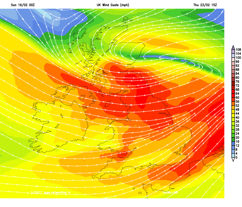
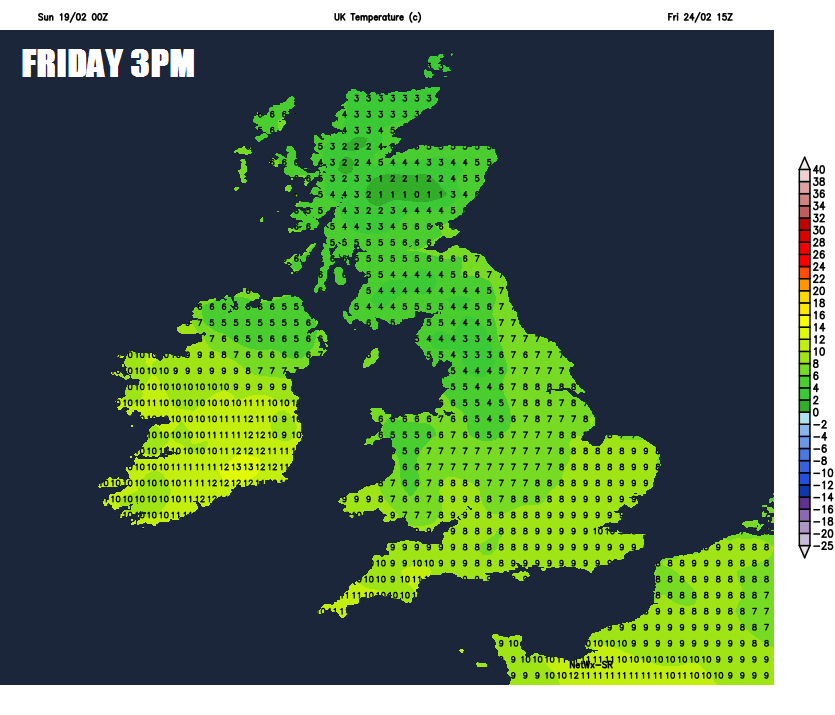
As the low exits into the North Sea Thursday evening/night, northerly or northwesterly gales developing which will drag down much colder air from the arctic, so temperatures struggling on Friday, 4-6C at best in the north, 7-9C in the south. Some hefty showers blowing through too, which will be wintry in nature across the north, though snowfall accumulations confined mostly to northern hills.
Temperatures struggling in single figures on Friday in the cold northwesterly flow