


Another winter storm about to hit New England, from summer heat back to winter chill in the southern U.S. High Plains and the Australian heatwave.

The weather on the whole has been pretty benign in the UK this winter, with high pressure dominating much of the time. And even when on the odd occasions where we’ve seen Atlantic storms or the threat of snow – again it’s generally not been too disruptive. The cold easterly snap with snow in places this weekend a case in point. The weather for the UK will turn less cold in the week ahead, as winds veer more southerly, but again the weather will be benign for most, thanks to high pressure close by, with just a little rain mid-week.
But some parts of the world are seeing extremes in weather at the moment, not just extremes of winter weather or heat, but even a sudden switch between the two, as I will go on to reveal in this blog.
Another winter storm for New England
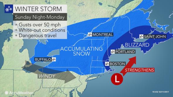
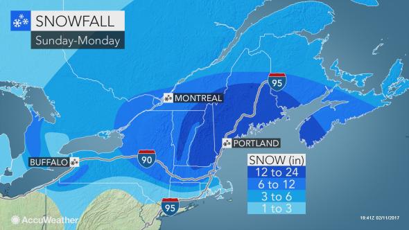
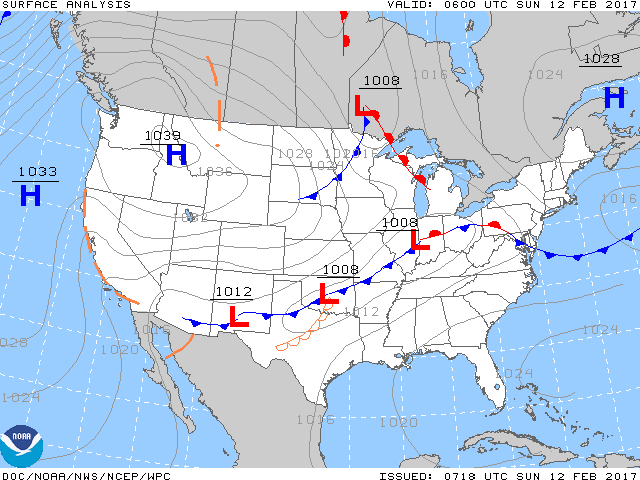
Hot on the heels of a winter storm that brought blizzards and up to 19 inches of snow across New England on Thursday, Winter Storm Orson looks set to arrive across New England by Monday, dumping up to 24 inches of snow. The low bringing the snowstorm moves out of the Ohio Valley to the west towards New England on Sunday, with very cold arctic air from interior Canada behind it. As the low moves offshore of New England later into Monday, it’s expected to ‘bomb-out’ or undergo ‘bombogenesis’ – this is where the low deepens rapidly (24mb in 24 hours) thanks the temperature contrast of cold continental air from the west passing over the warm moist Gulf Stream waters off New England combined with rising air in the exit region of a strong jet stream aloft. The deepening low strengthens the northeasterly wind, in the case of this storm, with 50-60mph gusts, creating blizzard conditions, given the large amount of moisture being drawn into the system from the Atlantic creating large snowfall. So expect major travel dispruption in the area.
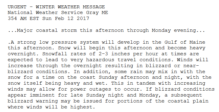
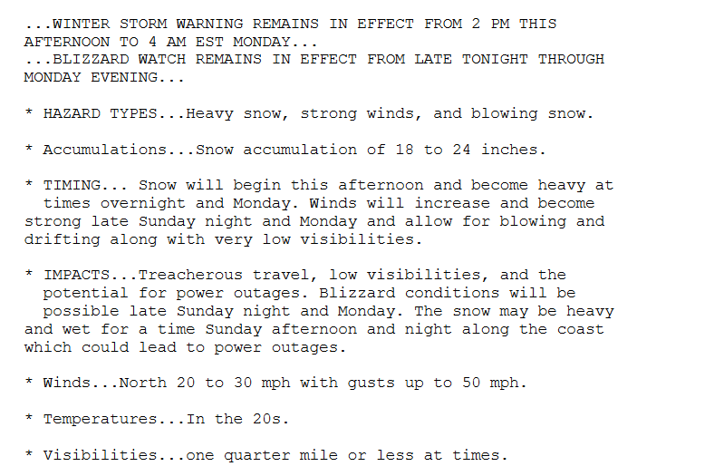
This is a winter storm weather warning issued by the U.S. National Weather Service:
New England winter storm impacts overview (images courtesy of Accuweather.com)
From record summer-like heat back to winter cold in 48 hours
Many locations on the southern Plains of America saw heat records shattered on Saturday, as southwest winds blowing up from Mexico and southerly winds off the Gulf of Mexico (which has above normal SSTs) sent temperatures in to the 80s and 90s Fahrenheit, with a few stations in SW Oklahoma hitting 100F! These sort of temperatures in February across SW Oklahoma are some 50-60F above normal. The very dry southwesterly flow of air downslope across the High Plains saw a big leap in temperatures from 30F (-1C) in the morning at Liberal in SW Kansas to 90F (32C) in the afternoon.
From summer heat to winter in 48 hrs across southern High Plains
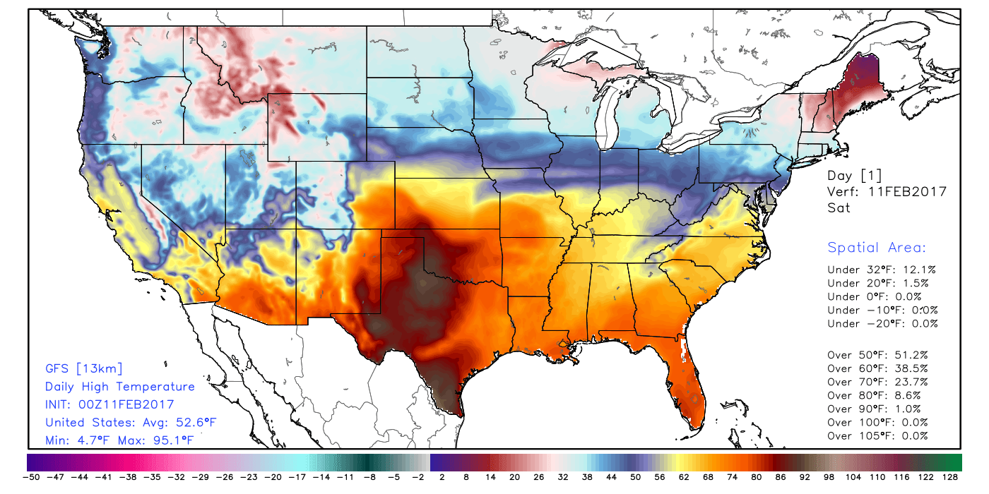
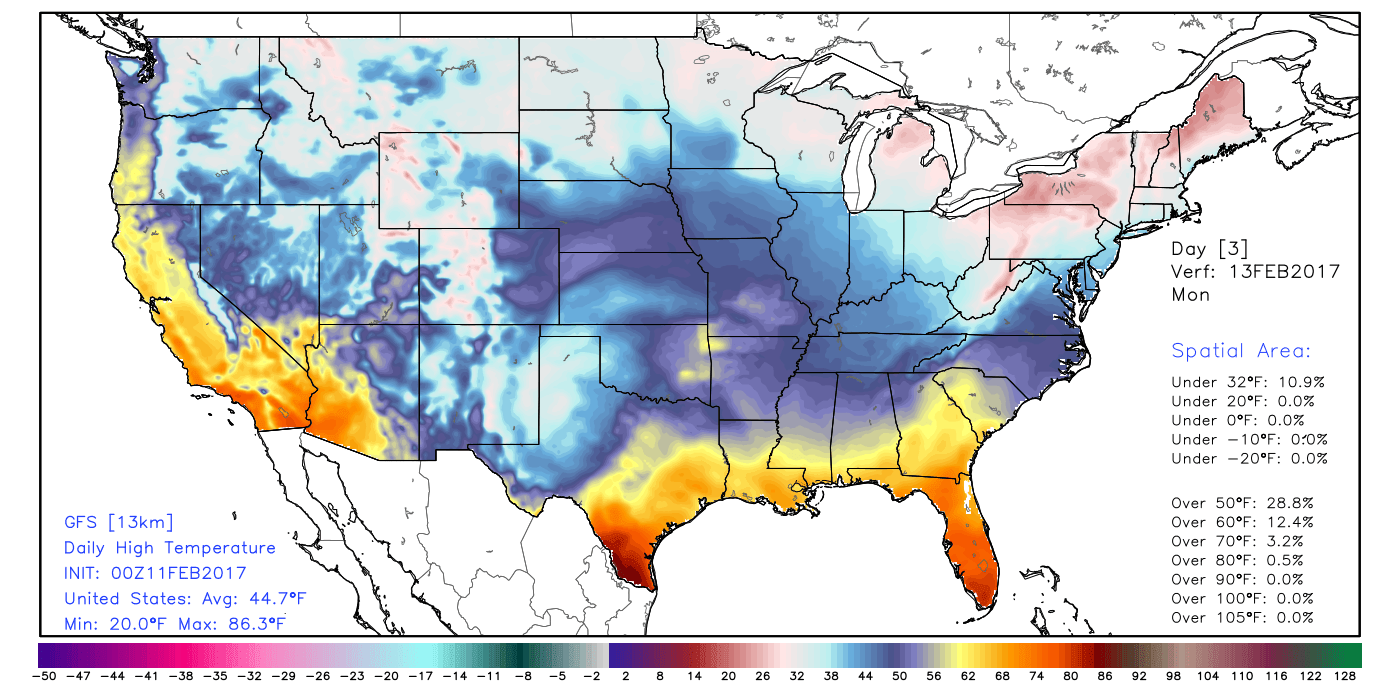
However, a potent cold front will sweep south across the southern Plains today, ending the extreme February heatwave. In addition, an upper-level low moving east from SW U.S.A / northern Mexico will bring rain, sleet and snow or freezing rain across the Texas and Oklahoma Panhandles by Tuesday, with temperatures falling to just above freezing by day and below freezing at night after the same areas saw temperatures in the high 80s and low 90s on Saturday!
Cold front sweeping south across southern U.S. scouring away the heat, while low over New England brings winter storm. sleet, snow and freezing rain arriving into High Plains Tuesday:
Amarillo in NW Texas hit 89F on Friday (beating previous record of 88F on 1st Feb 1963), 88F on Saturday. Lubbock hit 91F on Saturday, old record was 85F in 1962. These cities are forecast highs of 35-36F on Monday and are expecting snow on Tuesday, which is not unusual in itself in February for the High Plains, but the recent heat is!
Much of Australia is enduring an extreme heatwave, which worsened over the weekend. Interior parts of New South Wales, South Australia and Queensland hit the mid-40s centigrade again on Sunday. Thargomindah in Queensland’s hit 47.2C – the Australian state’s hottest ever February day. Parts of northwest New South Wales reached 45-46C.
The extreme heat and dry conditions has led to numerous bush fires too, which are burning out of control, especially across NSW where there are close to 100 fire burning across the state, threatening dozens of properties and lives. A trough moving northeast across central Australia and introducing a strong wind is exacerbating the fires. Apparently, some people have been arrested and charged for deliberately starting fires.
After Sydney on the NSW coast hit 40C on Saturday, cooler southerly winds arriving on Sunday have seen a drop in temperature with a high of 30C today, which will bring some relief. But interior parts of NSW and Queensland hung on to temperatures in the 40s today which, along with the strengthening southerly wind, is making firefighting conditions difficult, as a ‘fire front’ along the strengthening wind shift develops as it moves north.
So, we can’t really complain about the weather in the UK, as most of the time, it’s pretty benign compared to what some parts of the world experience on a fairly regular basis in winter or summer – when extremes of heat or cold are most acute.


