High pressure over Scandinavia bringing a fall in temperatures during the coming days.
Issued at 1500GMT on Tuesday 7th Feb based on 7th Feb 00Z Model Runs
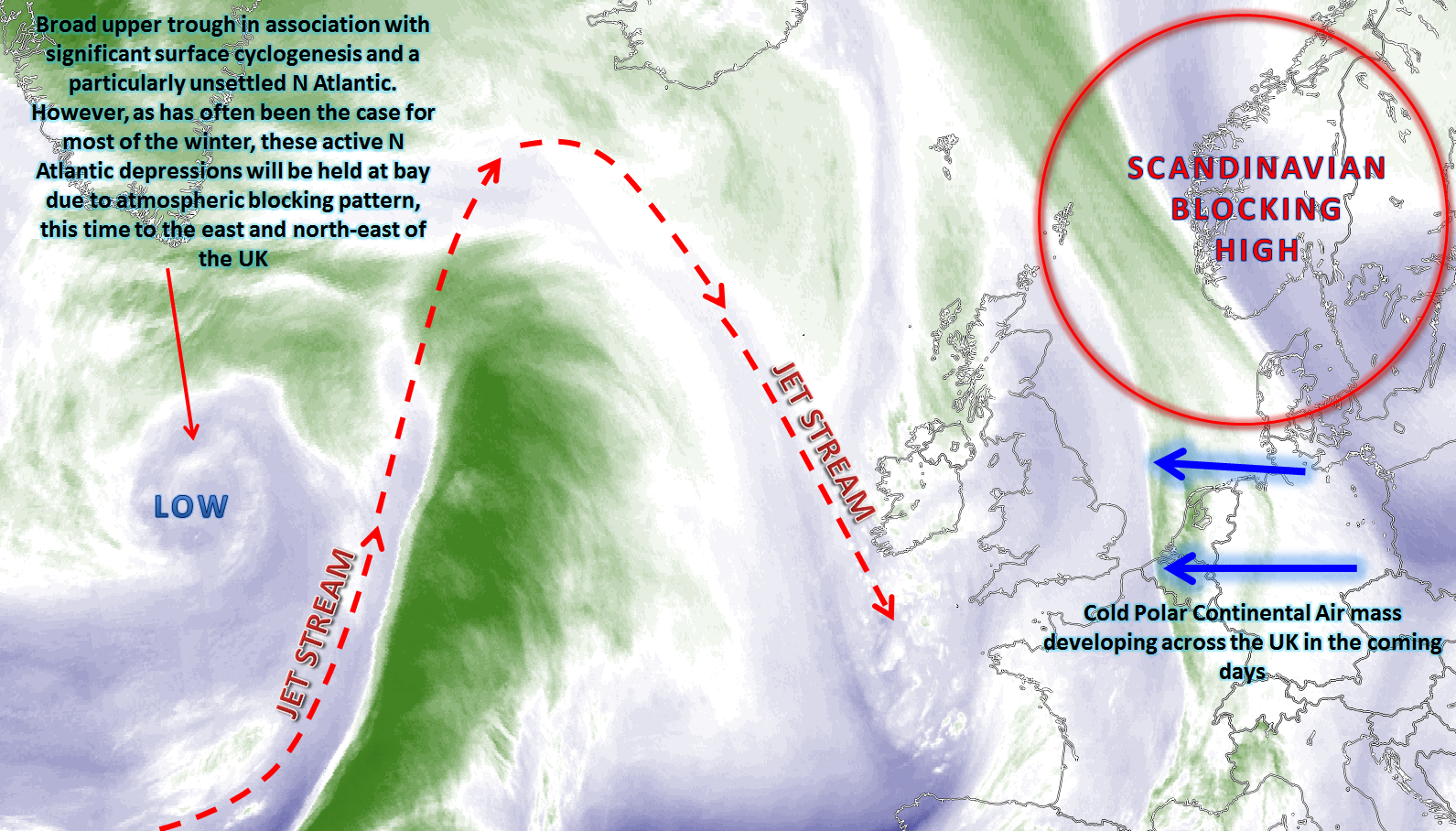
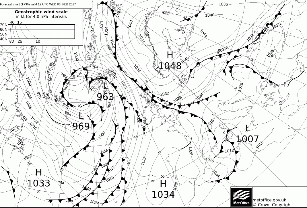
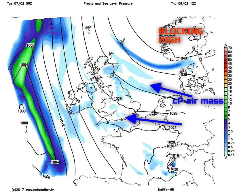
Wed 8th Feb: Wednesday is the ‘day of change’, especially for most of England, Wales and Scotland as a large blocking area of high pressure, which is forecast to have a central pressure of around 1048mb by 1200Z, will dominate across northern and north-west Europe. A frontal system that has moved across the UK through the course of today (Tuesday) will be held at bay just off the E Coast of England tonight, before then moving back westwards through Wednesday as a weakening feature. All model guidance indicates this synoptic evolution and whilst forcing along the frontal zone will be insignificant, the important aspect of the front is that it will be the boundary between much colder air trying to move into the UK on an E or SE’ly airflow. The evolution through the day will be for more western areas of the UK to essentially be under rigid conditions, with some subsidence evidence within forecast soundings. This means that more western parts of Scotland, Ireland, W Wales and SW England will likely have a mainly dry day with some bright or sunny spells, albeit with an increasingly cold feel. For the rest of the UK, essentially most of England and central and eastern areas of Scotland, it will be cloudier as the frontal system retrogresses across the UK. Some sporadic regions of light rain, sleet and snow are possible, and it will be quite a grey and overcast day. As the colder air mass begins to filter in, then temperatures will generally fall as Wednesday progresses with an increasingly cold and raw feel. The weakening (frontolysis) frontal zone is well marked on the UKMO FAX for 1200Z on Wednesday, note to the blocking high pressure well established across Scandinavia.
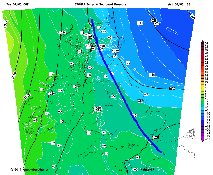
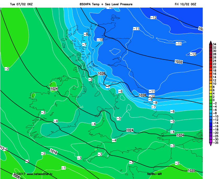
The air mass that is trying to move into the UK is most certainly a Polar Continental one, with its origins from across more central and eastern areas of Europe, around the southern flank of the blocking high pressure over Scandinavia. The air mass is most likely to be the coldest air mass to affect the UK so far this winter and our HRES model highlights this thermal gradient across the UK well, noting 850mb temperatures of -1C to -3C across Ireland, whilst behind the front, just off the E Coast of England 850mb temperatures are at or below -10C. As a general rule of thumb -10C 850mb temperatures from the UK’s perspective is often the benchmark for bringing snow to all levels and also indicate a particularly noteworthy cold spell. The general location of the surface front has been drawn on too, but this will continue to be a particularly weak feature by this point.
Thu 9th Feb: As we progress into Thursday and there is good model agreement for the blocking Scandinavia high pressure to be dominating the weather across N Europe and also across the UK too. A broad upper-trough will be in evidence to the west of the UK, but the pattern across the N Atlantic and into N Europe will, essentially, be blocked with little scope for any eastward progression of the normal westerly flow. It will be a cold start to Thursday with a fairly widespread frost in evidence, this locally moderate or severe, given low Td’s and also a light or moderate E or SE’ly breeze.
The weather itself during the day will be very quiet and benign overall, with most of the UK predominantly dry with some bright or sunny spells, especially across western areas, but with a lot of lower cloud in evidence across England, Wales and Scotland. More of a S’ly airflow is expected across Ireland, so it is across Ireland the ‘mildest’ conditions will be during the day, but for England, Wales and Scotland a Polar Continental air mass will now be in place. The cloud may well be thick enough for some light snow showers, flurries or snow grains, especially across central and eastern areas of England and Scotland where some slight accumulations are possible by the end of the day. Our MR range model highlights the blocked regime well and also note to the signal for some light precipitation across more eastern areas of England and up into eastern Scotland on the SE’ly breeze.
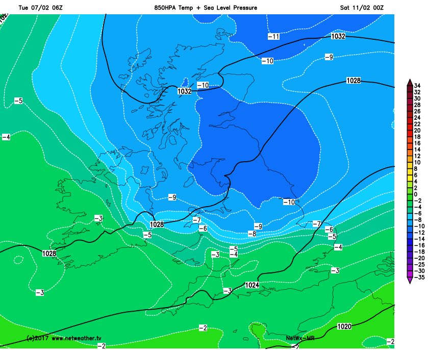
Whilst 850mb temperatures, amongst other indicators of air mass type and temperature, don’t tell the whole story when it comes to a Continental flow, as more often than not the coldest air mass is beneath the 850mb level, it is worth highlighting that by late Thursday many northern and eastern areas of the UK will begin to see the -10C isotherm, at the 850mb level, move into the UK, as exampled by our MR model.
Fri 10th Feb: By the time we get into Friday and all areas of the UK will then be dominated by a cold or very cold Polar Continental air mass. Once again, though, the emphasis is on a lot of fine and dry weather, especially across more western areas of the UK with some sunshine. This will be after a cold or very cold start with a widespread moderate or locally severe frost, this penetrating too given the depth of cold to the air mass coupled with the E or SE’ly breeze. With more of an E’ly component to the flow into Friday then there is a greater chance of some light snow showers, or flurries, moving into central and eastern areas of England and, as a result, some slight accumulations are certainly possible across eastern regions of the UK generally as Friday progresses. A cold day for all, perhaps an ice day too, especially above 250m or so across Scotland and N England, otherwise temperatures will just be a few degrees above freezing and a frost will soon re-develop during the latter half of the afternoon onwards. It is this through Friday as well that the coldest air mass of the winter so far will move down into the UK from the east and north-east, given more of an E’ly component to the wind direction, this highlighted well by our MR model.
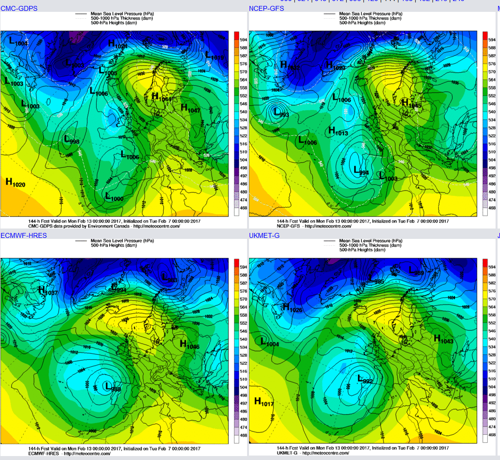
Sat 11th and Sun 12th: As we progress into the coming weekend and whilst there are some uncertainties over the details, there were some good model agreement from the 00Z models regarding a more pronounced region of vorticity and lower atmospheric pressure, especially within the upper atmosphere, approaching from the east during the weekend. The weekend is likely to start cold or very cold almost nationwide with a harsh and penetrating frost, locally severe over any snow cover as well across more central and eastern areas of the UK. However, attention is then drawn to this more cyclonic region of weather within the atmosphere that is currently being modelled and this region of vorticity and lower GPH is highlighted well on the UKMO, GEM, GFS and ECMWF model as we move into Saturday.
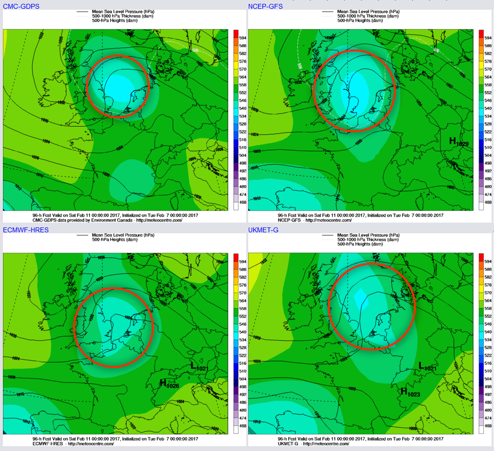
Whilst all the main GM’s do indicate this feature, there are differences over the orientation and general structure of this region of more disturbed weather trying to move in from the east, which is understandable at this time frame. However, the important aspect is this region of vorticity is likely to lead to a more unstable atmospheric profile across central and eastern areas of the UK in particular and hence lead to a heightened risk of some snow showers moving into the UK from the east. What is made more complicated is that this feature is likely to move into the UK with a less-cold air mass than compared with Thursday and Friday, so more coastal areas of E England, for example, could well see any snow revert to sleet or rain, but come further inland and snow is most certainly likely to be the dominant weather type.
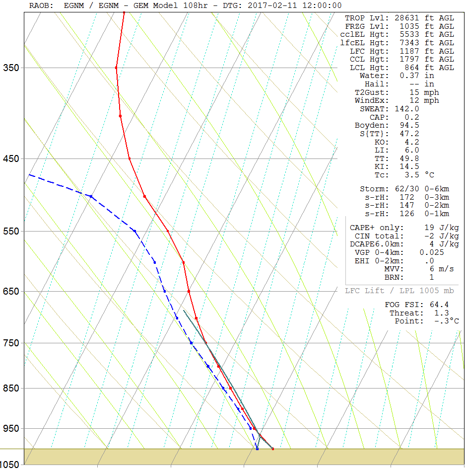
So, after the cold or very cold and frosty start to Saturday wintry showers across eastern areas may well then progress further inland across England and Wales in particular during the day, perhaps bringing several centimetres of snow to some areas, depending on the local intensity and frequency of the showers and perhaps especially above 150m to 200m or so. There could also be some snow showers too across parts of Scotland. Many western areas of the UK though will, overall, likely remain mainly dry with some further bright or sunny spells. Highlighting this process of a more pronounced region of instability and cloud development within the atmosphere is the below forecast sounding for Leeds at 1200Z on Sat. Note a lot of moisture within the lower layers of the atmosphere (blue and red lines close together), and there is some evidence of instability up to around 8,000ft or more which would promote some moderate snow showers too.
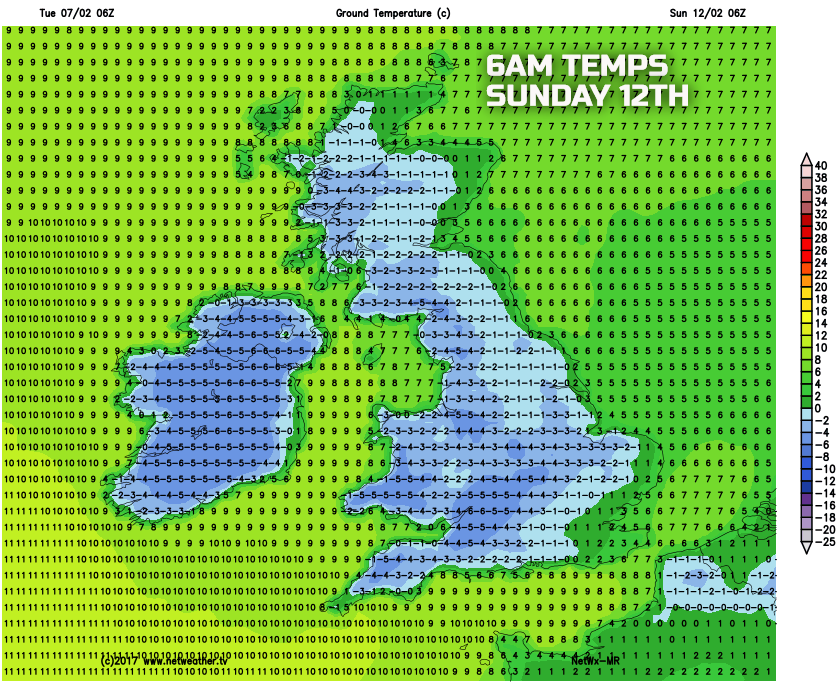
The cold and wintry regime is then likely to continue into Sunday, another frosty and potentially icy night is possible on Saturday and into Sunday morning across many areas, again frost and ice most prevalent over snow cover where locally severe and penetrating too given a moderate or perhaps fresh E or NE’ly breeze which will maintain a significant wind-chill factor across the country. Some further wintry flurries certainly seem possible still, but details of this are uncertain, but the main emphasis for the weekend at the moment is that whilst temperatures may just increase slightly, given the slightly less-cold air mass, there is likely to be an increased risk of seeing some snow this weekend for some areas of the UK. As usual, it is worth highlighting that not everywhere will see snow and there could well be a very fine margin, between rain and sleet near more eastern coastal areas of England, but come further in-land, especially with a little altitude and it could well be a local ‘winter wonderland’ with a decent snow cover, temperatures barely above freezing by day and sub-zero at night, perhaps with some focus for these kinds of conditions to be across parts of Northumberland, Yorkshire, E Lancashire, Lincolnshire and into some parts of the Midlands too. Our medium range model for early Sunday morning highlights some particularly low minimum temperatures, but note that small region of eastern England and Scotland where temperatures are likely to be around or above freezing into early Sunday, whilst the further in-land and further west you progresses, the lower temperatures become.
As we progress into next week and there does seem to be some model agreement and consensus, especially when you look at the ENS output too, for the position of the high pressure to combine with lower pressure to the west and south-west to signal a potential SE’ly flow off the near Continent. This does mean a continuation of further cold weather, but not to the extent of previous days, but there does seem to be some agreement too within the models for this SE’ly flow to be fresh or strong, and this would lead to quite a significant wind-chill factor. So, at the moment at least, a progression towards less-cold weather is expected into early next week, but it will likely remain mainly dry with some overnight frost and still generally remaining quite cold, but just not to the extent as what is expected in the coming days.
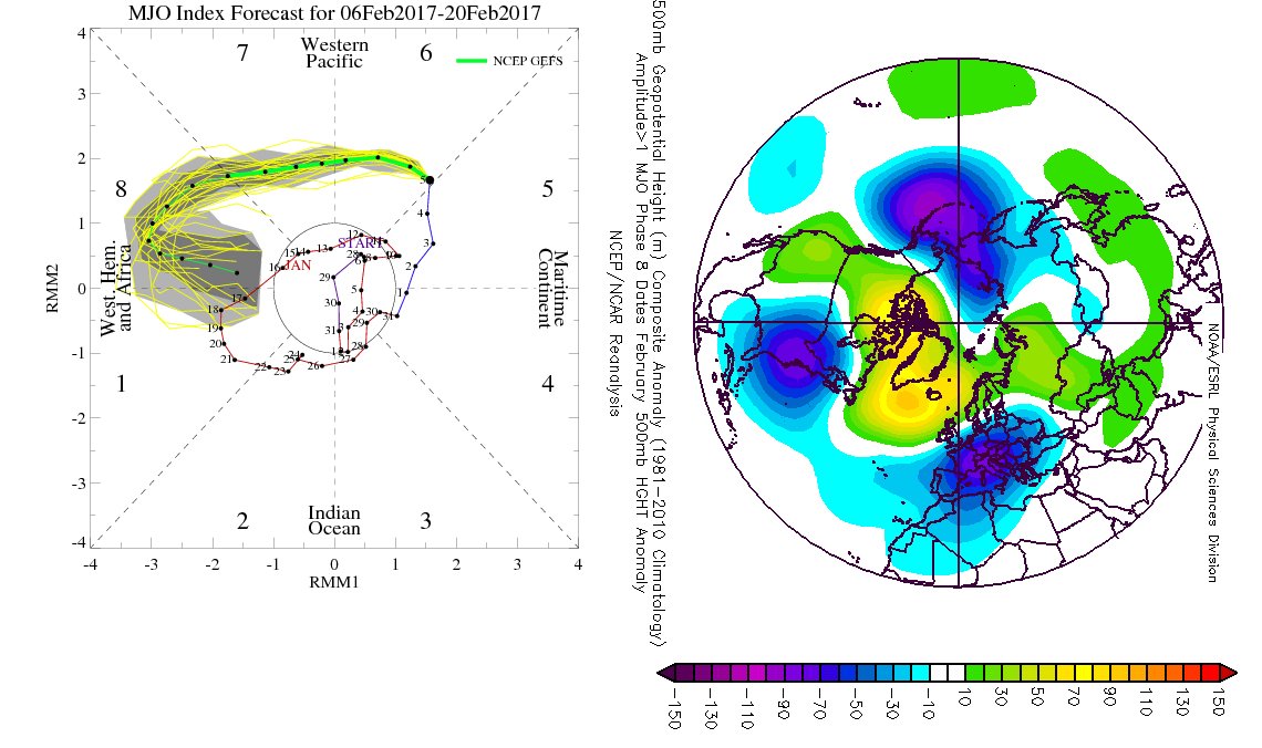
Looking further ahead and continued developments within the stratosphere and also continued model agreement and consistency for the MJO to progress towards phase 7 and phase 8 within the next 10 days or so, means that there is still an on-going signal this week for further blocking patterns to develop as the rest of February progresses. The MJO signal, in particular, is really quite strong and it could well become a high amplitude phase 8 ‘event’ and clearly for a February month that often equates to a –ve AO and especially a –ve NAO pattern with high pressure over Greenland. So, as things stand I do believe there is a good chance that at some point during the second half of
February, perhaps into early March too that a Greenland block may well make an appearance with perhaps cold weather arriving from the north or north-east, one to definitely keep an eye on as the final third of winter progresses and for those looking for some early Spring weather could well be disappointed.