Plenty to talk about in todays synoptic guidance blog.
Issued at 1500GMT on Tuesday 31st Jan based on 31st Jan 00Z Model Runs
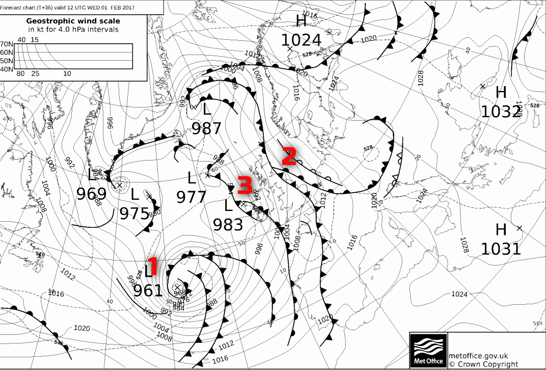
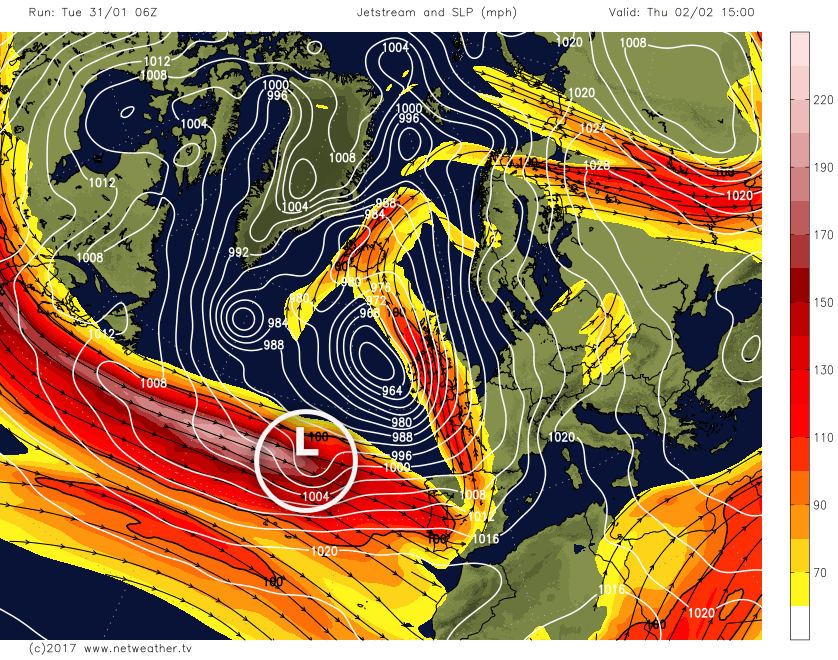
Wed 1st Feb: Into Wednesday and the broader synoptic pattern does have good agreement with the main GM’s (ECMWF, GFS, UKMO and GEM) all highlighting a developing area of low pressure (1) within the left exit region of the stream moving across the N Atlantic, but at a rather low latitude, generally south of 50N in association with the S’ly tracking jet stream. This low pressure will be a feature of the weather for Thursday.
Across the UK though Wednesday’s weather is particularly mobile and, as a result, there are some uncertainties over the details. One set of fronts (2) will be bringing some light or moderate frontal rain to eastern areas of the UK during the morning, but these fronts will then clear. Following on behind will be a relatively weaker system (3), due to a lack of forcing more than anything, but it will introduce some rain and drizzle into western areas of the UK through the day. However, between these two systems a ‘window’ of fine weather is expected and, as a result, Wednesday more central areas of the UK will be a reasonable day with some bright or sunny intervals, and it will be mainly dry. Some fine weather will also extend to more eastern areas of England too as the day progresses once the morning frontal rain clears.
Highlighting this general synoptic setup is the latest UKMO FAX chart for T+36hr with each feature highlighted and annotated with the associated numbers.
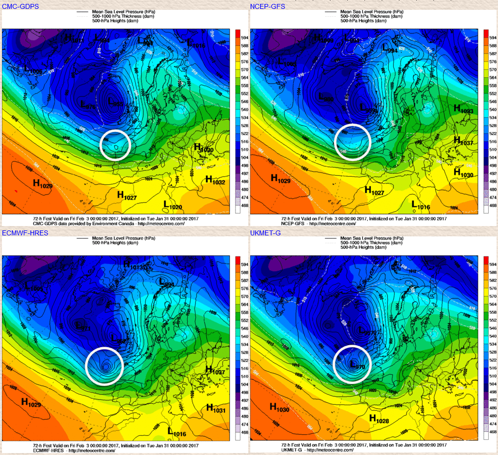
Thu 2nd Feb: As we progress into Thursday and there is generally good model consistency and agreement for the developing area of low pressure to then approach from the SW and become the dominant feature of the weather. The central pressure of this system is set to be around 960mb, but there are some variations in the output from the models, with the EC having the highest pressure by 0000Z Thu at 965mb, but with the GEM model having the pressure near 957mb. Despite some differences in the depth of the low pressure the overall consistency is good regarding this low pressure approaching from the SW and then tracking just to the west of Ireland to become located to the NW of Ireland by the time we get to the end of Thursday.
Despite what looks to be quite an active low pressure the general forcing associated with the frontal zones remains rather ragged and not directly associated with the frontal zones themselves. As a result, precipitation associated with the warm and cold fronts that will move north and east across the UK during the day will be quite sporadic and potentially warm advection driven too with some locally large rainfall totals arriving across south-western facing upslopes, so parts of S Wales and SW Scotland for example. It will become windy through the day, nothing too untoward yet given the time of year but compared with the last few weeks then a fresh or strong, locally gale force S or SW’ly wind will be noticeable, especially across exposed coasts and hills of the north and west.
So, overall, Thursday is an unsettled day in association with this low pressure passing to the west of the UK with outbreaks of rain and showers moving north and east along with strong winds too. The 00Z GEM model does highlight the rather ragged regions of vorticity (pink areas) moving northwards across the UK through the day and perhaps with some standing wave development too, but the largest rainfall totals will likely be on south or south-west facing hills.
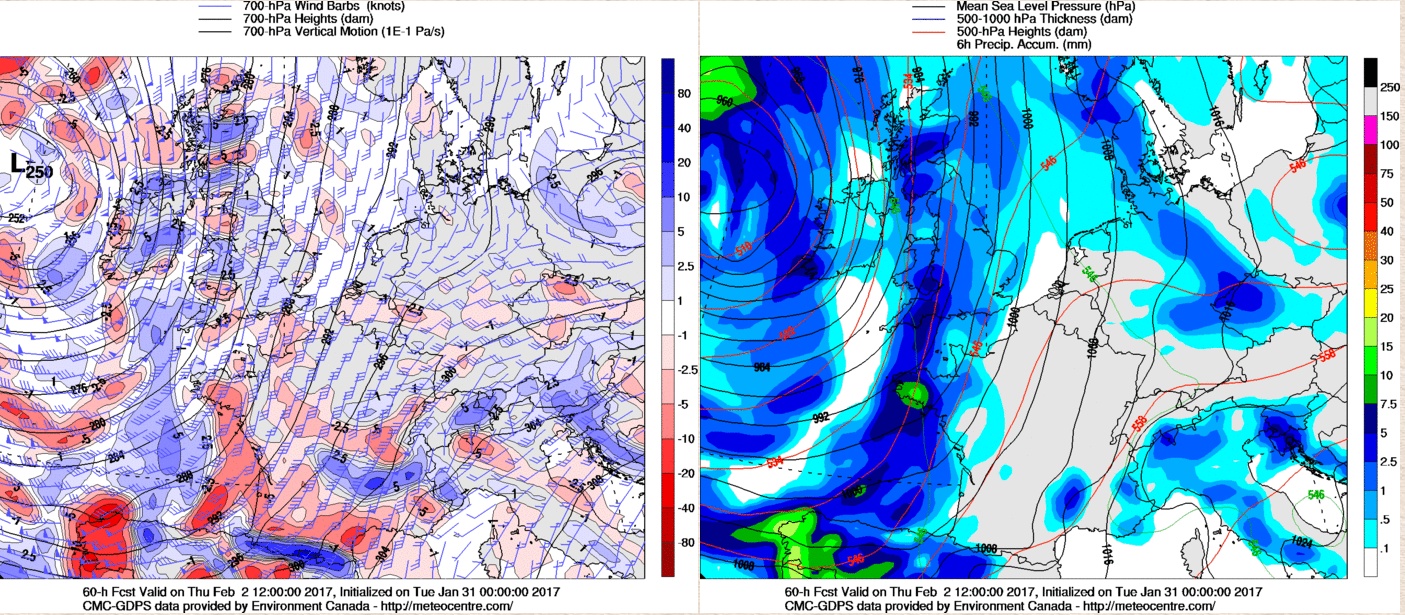
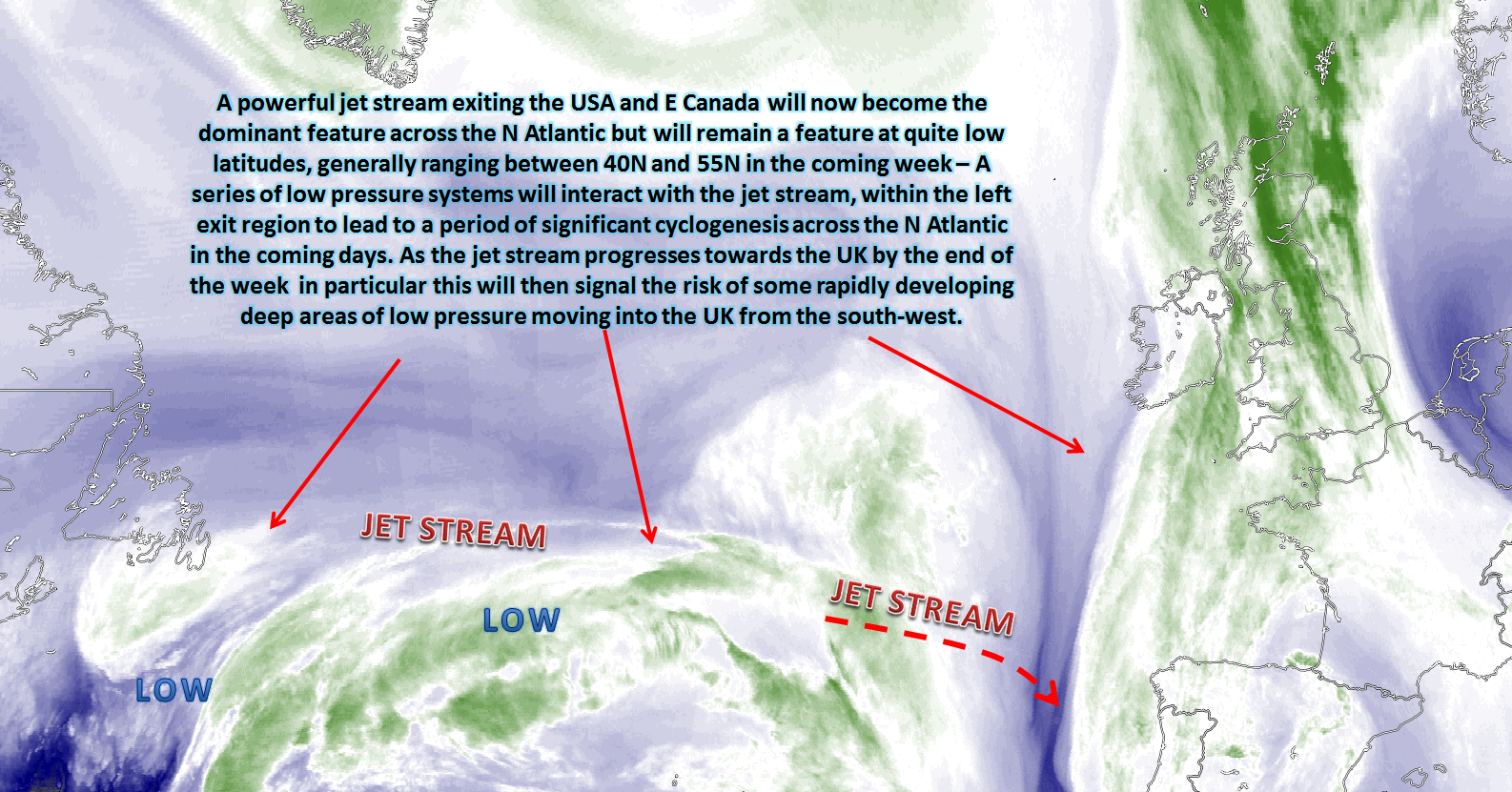
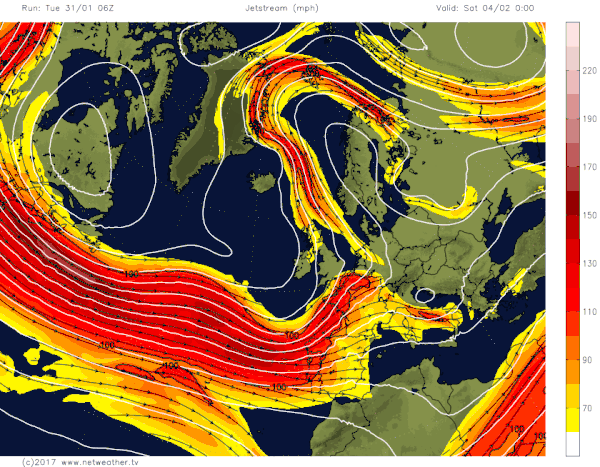
During Thursday a short wave will have moved out of eastern areas of the USA and will likely be picked up within the left exit region of the jet stream. There is uncertainty over the development of this feature though as, currently, it can be traced back to mainland USA and then the intricacies of it as it develops in direct association with the jet stream mean some question marks. However, whilst not a feature for Thursday it is prudent to highlight this feature as part of Thursday’s forecast as it will rapidly become a feature of interest to end the week. The feature in question can be seen on the GFS chart below, note it is sitting on the ‘cold side’ of the jet stream later on Thursday.
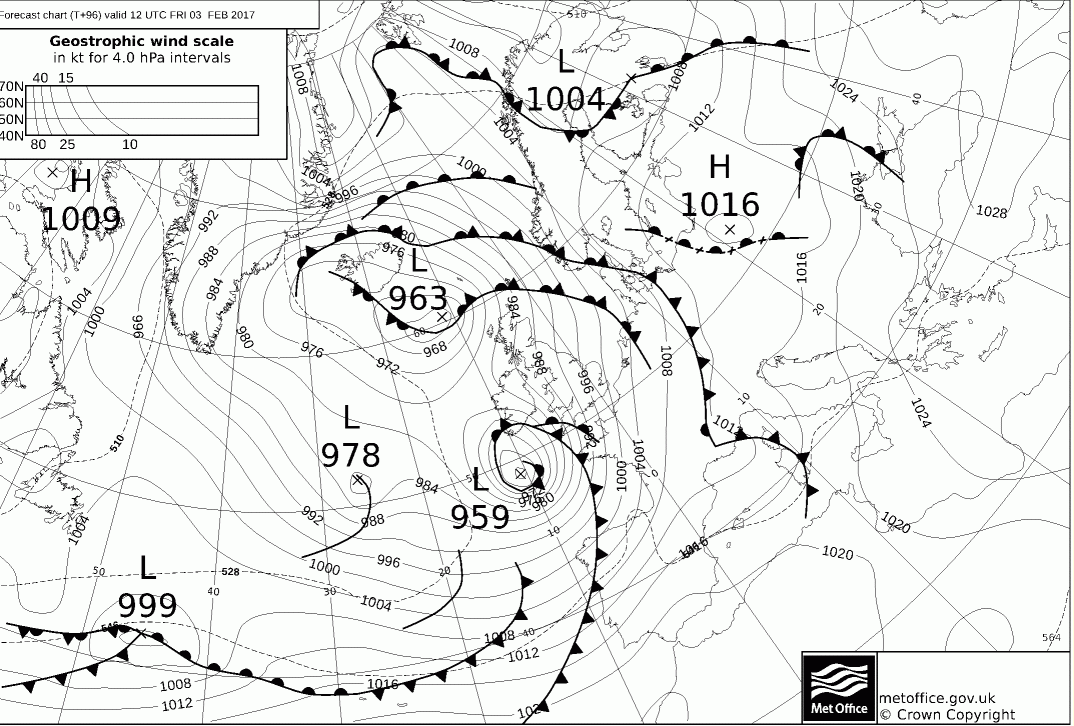
Fri 3rd Feb: By the time we get into Friday the developing low pressure will be already moving into SW England. The S’ly track of the jet stream means that rather than approaching from the more typical W’ly direction, the developing low pressure will move into the UK directly from the SW. It should be emphasised still that the uncertainties over the developments of this system still mean that the details for Friday’s weather are uncertain. However, it is likely to be a wet and windy start to Friday across parts of Ireland, Wales and SW England.
Gales and perhaps severe gales will begin to develop on the southern flank of the low pressure in particular along with some heavy rain wrapped around the main surface low pressure. For more northern and eastern areas of the UK though it looks set to be a relatively dry and fine start to Friday with some bright or sunny spells too. At 00Z on Fri the UKMO and ECMWF are particularly pronounced in terms of development with a small but potent low pressure approaching from the SW. The GFS and the GEM models though are less significant at this stage, and again this highlights the uncertainty over its development, but for now at the least the UKMO, ECMWF and the likes of the ARPEGE which support the ECM and UKMO and are the preferred models.
As Friday progresses and this low pressure is currently set to track north-eastwards across the UK. As a result, increasingly unsettled conditions will then spread north-eastwards across the UK with a spell of moderate or heavy rain then potentially being followed by blustery showers from the south-west during the day. Importantly will be the strength of the winds wrapped around the low pressure which could well be in a state of deepening as it tracks north-eastwards. Particularly along the southern and western flank of the low pressure then gales or severe gales may well develop. From experience, this setup can certainly lead to some severe wind gusts on a more local and regional scale with perhaps parts of Wales, Midlands, N England and S Scotland all at risk of some very strong wind gusts later on Friday and then overnight into Saturday as this system tracks north-eastwards.A feature to keep an eye on in the days ahead, particularly seeing there does remain some uncertainty over the development of this low. However, the UKMO FAX at T+84hr highlights what may well be possible as this low pressure moves into the UK from the SW, noting the close proximity of the isobars on the southern flank of the low.
Sat 4th and Sun 5th: As we progress into the coming weekend and confidence in the details of the weather really does drop away. The generally southerly track jet across the N Atlantic is forecast to continue, and the consensus between the models is for further cyclogenesis and for further areas of low pressure to potentially interact with the UK to bring about some further potential wet and windy weather, or perhaps even some stormy weather too. However, the models diverge considerably over the development of further short waves running across the N Atlantic on the polar side of the jet stream. This is highlighted well by the 00Z main GM’s for 0000Z Sun 5th, with some agreement between the UKMO and ECMWF models to an extent, but overall the GFS and the GEM show multiple low pressure systems. A cyclonic pattern is expected, so further unsettled conditions are likely for all areas of the UK, but to what extent is highly uncertain at the moment.
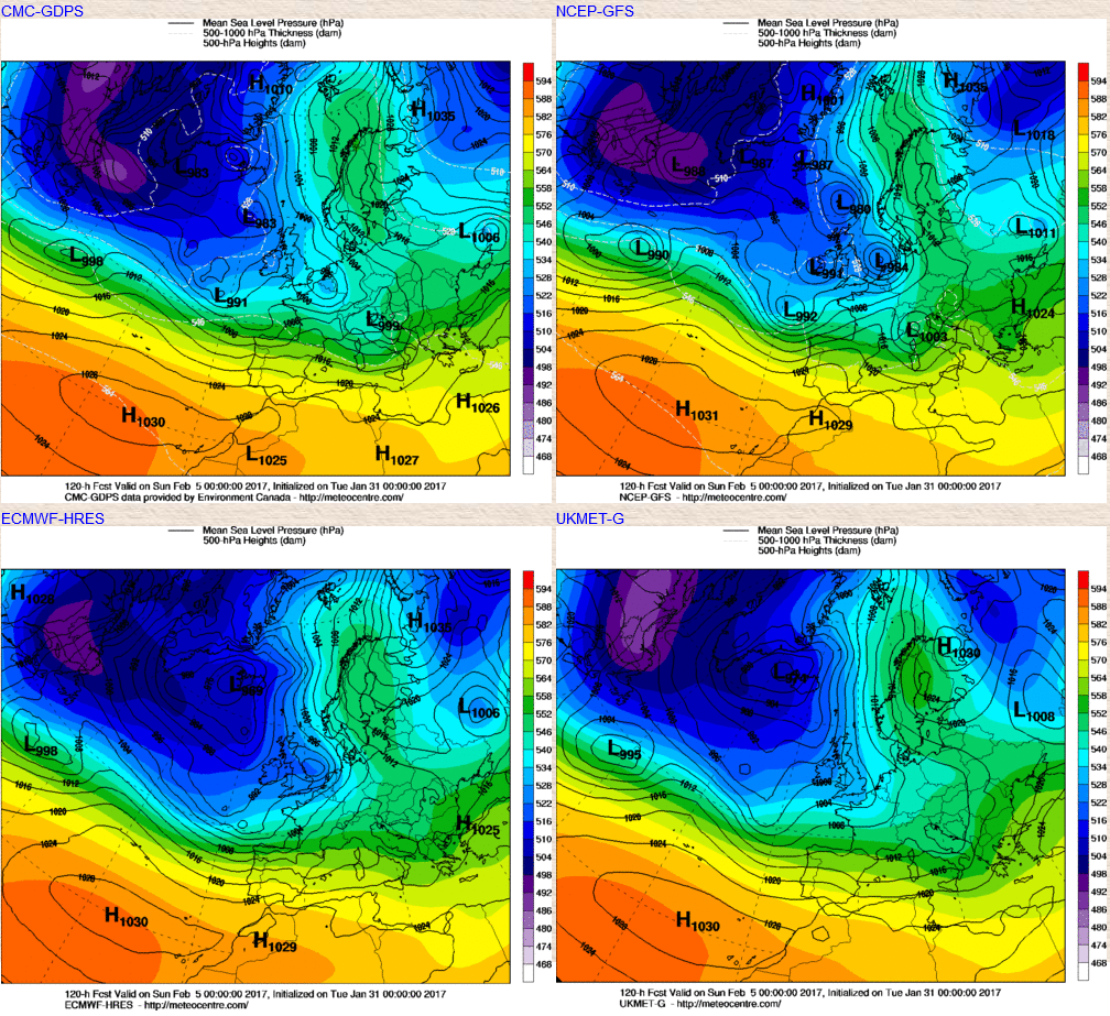
With the jet stream continuing to be positioned along a particularly southern track and low latitude then there is certainly scope for further low pressure systems to quickly develop as they interact with the jet stream. The GFS model highlights the general position of the jet stream well as we move into the weekend. So, expect further cyclonic developments with the potential for further showers, longer spells of rain and windy weather to and perhaps with some sleet and snow as well on the higher ground as temperature’s fall, in comparison to the next few days.
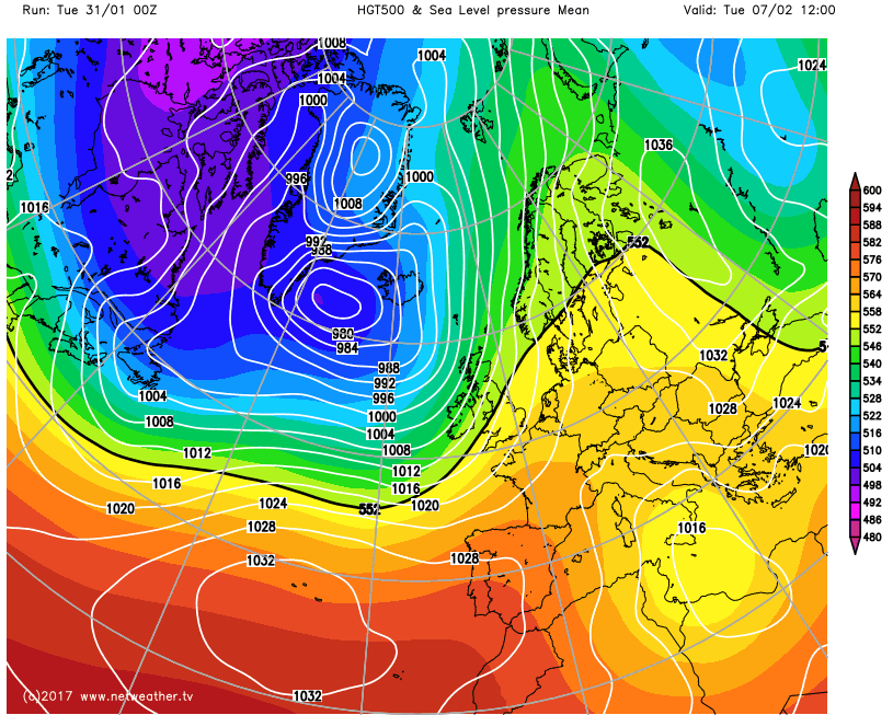
The progression towards more unsettled conditions has been well signalled for some time now it was always more a case of when it would arrive rather than if. At the moment the cyclonic pattern is forecast to continue beyond the opening week of February, and this is highlighted by the GFS ENS mean as an example. There may well be a change in the position of the jet stream which means areas of low pressure track more towards the north-west of the UK, the usual and climatological track, with more southern and south-eastern areas of the UK becoming drier. However, the overall pattern is still a mobile one across the N Atlantic and into the UK.
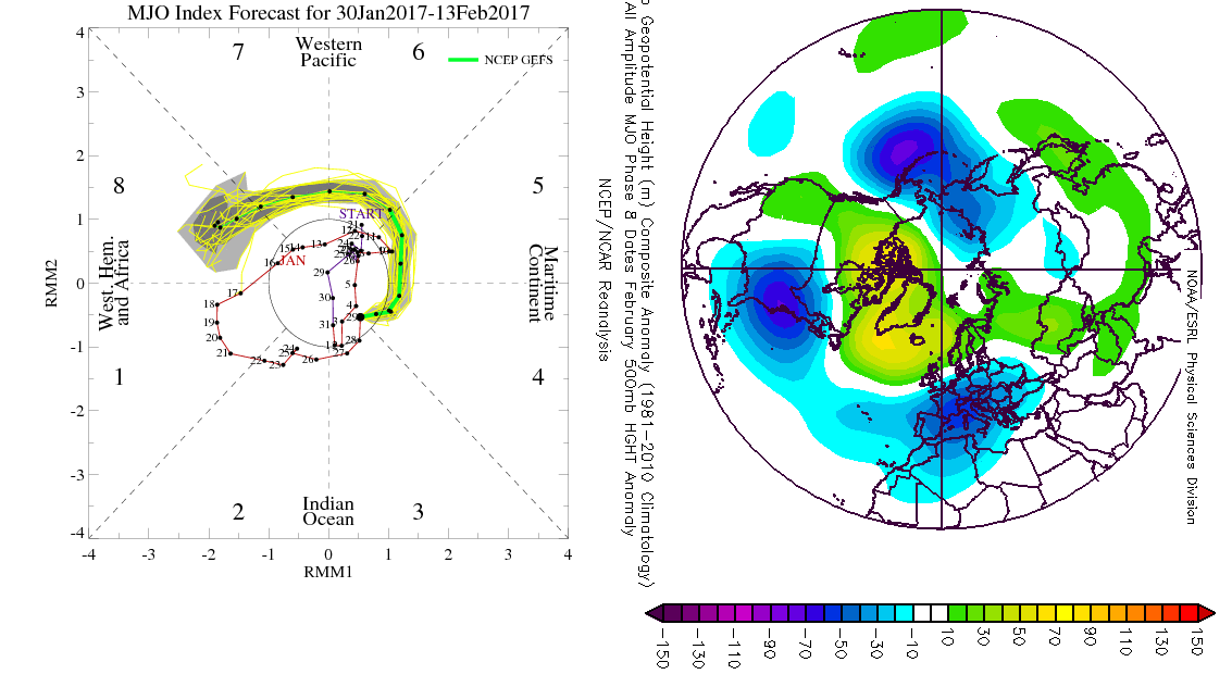
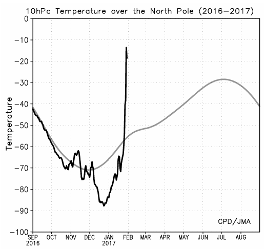
Looking further ahead and it is currently a talking point that conditions within the stratosphere are undergoing a warming phase and that is certainly expected to continue in the coming days. As ever to what extent any warming and disruption of the stratospheric polar vortex will have within the troposphere is yet to be seen. However, this development coupled with some signals that the MJO may well move around towards phase 7 and phase 8 within the next 10 to 14 days, means that the second half of February could well be very different to the first half of the month. This warming within the stratosphere is highlighted well by the below chart showing temperatures at 10hPa over the North Pole. The rapid rise in temperature is clearly textbook in terms of indicating some marked warm with temperatures rising over 60C within a very short space of time.
The potential progression of the MJO around into phase 7 and phase 8 is highlighted well in the below image. Whilst not all models agree on this trend, there is some agreement though from the likes of the ECMWF and other models for this to happen. Analysis of the MJO in phase 8 during a February month would lead to a particularly –ve NAO pattern and a potential –ve AO pattern too. This is something the overnight update of the EC Monthly has indicated from and beyond the middle of the month with a far more significant amount of northern blocking than compared with the first half of the month. As a result, my latest thinking and thoughts are that the second half of February could well progress back towards a more blocked regime and potentially with colder weather as well, perhaps originating from the E or NE, so potentially very cold. As ever though this blocked pattern needs to materialise first before any cold weather becomes likely and only time will tell as to whether it will.