High pressure staying dominant during the first week of 2017.
Issued at 1500GMT on Tuesday 3rd Jan based on 3rd Jan 00Z Model Runs
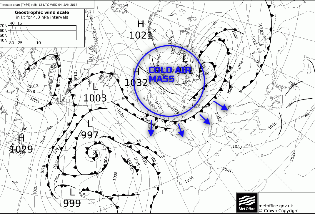
Wed 4th: As we move into Wednesday and model agreement continues to be good with the GEM, GFS, EC, UKMO and JMA all showing a reorientation of the upper pattern with an area of high pressure becoming located over most areas of the UK. Cyclogenesis will take place to the north-east of the UK through the day and the surface cold front associated with the developing low pressure is expected to move south and west across most areas throughout the course of the day.
However, all models are in agreement for the cold front to be a particularly weak feature with little forcing as it moves down into the region of high pressure across the UK and associated subsidence. It will, however, still be a boundary between relatively mild air across more southern and western areas of the UK and colder air into the north and east. This is the primary feature of the weather during the day on Wednesday as the cold front moves southwards and westwards it will introduce a drier and colder air mass once again from the north. Some patchy light rain and drizzle will be associated with the front, but nothing more than this with the front then becoming slow moving across parts of SW England and Ireland later in the day, where it will remain somewhat milder and cloudier. However, for most of the UK cloud will break as Wednesday progresses and this will lead to increasing amounts of sunshine through the day but with then a significant diurnal drop in temperature as we move into Wednesday evening.
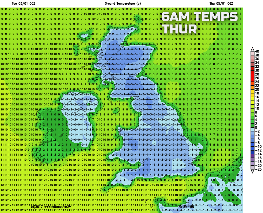
Wednesday night is then set to be a cold night with a widespread frost across England, Wales and Ireland and this could well then be the last frost across the UK in quite some time. The cold front in question is well marked on the UKMO FAX for 12Z on Wednesday, and it is behind this that the drier, clearer and colder air mass will then filter southwards to most areas through the day re-introducing similar weather to that of New Year’s Day and Bank Holiday Monday.
Thu 5th: We move into Thursday with all main GM’s in good agreement for high pressure to be situated over the UK with a central pressure of around 1034mb centred over the Midlands. It will, after plenty of clear skies and near-perfect radiative conditions, be a cold start to the day with a widespread frost, this moderate or perhaps even severe in prone frost hollows in particular. For many areas of the UK, though the anticyclonic conditions will then prevail and this means that most of England, Wales and Scotland will experience a dry day with plenty of winter sunshine after the cold start.
Temperatures will struggle despite the sunshine, and it will be a cold day in many areas. Weak frontal zone over Ireland and perhaps SW England though will lead to cloudier conditions here with perhaps some patchy light rain and drizzle possible, and it is across more extreme western and south-western areas of the UK that temperatures, overall, will be higher than elsewhere. Later in the day and model agreement continues to be good for more active frontal systems to approach northern and western areas of the UK as the high pressure declines down into the near Continent. It could well be another cold evening and night across parts of England and Wales on Thursday, but the emphasis is on increasing amounts of forcing and more active frontal systems to move into Scotland and Ireland into the overnight period, along with a milder SW’ly air mass as well.
Emphasis for Thursday though is for many to have a dry and benign day with plenty of winter sunshine after a particularly cold start and of which is emphasised and highlighted well by our medium range model with clearly an almost nationwide sub-zero start to the day.
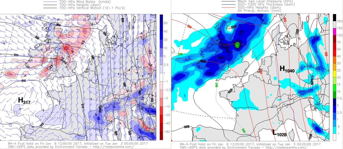
Fri 6th: The week ends with more active frontal systems moving across the UK during the day to bring about a more significant period of dynamic, frontal rain for parts of the UK. Overall high pressure is still the dominant weather type across most of the UK with atmospheric pressure, across England and Wales at least, above 1028mb from most of the GM’s. However, there is certainly evidence to suggest that the frontal systems crossing the UK during the day will have more forcing associated with them and hence a greater risk of more persistent rain generally moving north-west to south-east across the UK during the day.
The largest rainfall totals look set to be across parts of Scotland, Ireland and N England, but with time the forcing relaxes away to the east and north-east, so by the time the frontal zones do get down towards S England later in the day, then precipitation intensities by this point will have eased away. Following on behind will be another rise in pressure. Most of Scotland, Ireland, N England and Wales will end the day drier, but mostly cloudy with a lot of boundary layer cloud in what will be quite a mild air mass by this time too, which will have its origins to the west and south-west of the UK. Highlighting this evolution well is the GEM model with some marked forcing visible (left image, pink shadings) moving down across the UK and this ties in with some moderate or locally heavy outbreaks of rain for more northern and western areas before the forcing then eases later in the day as the fronts move south-eastwards.
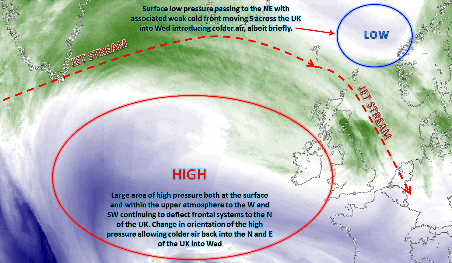
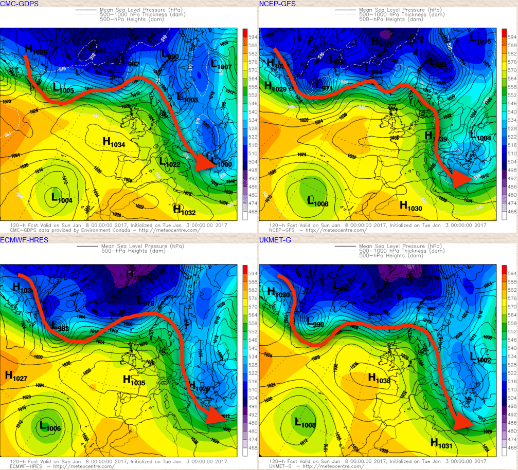
Sat 7th and Sun 8th: As we progress into the coming weekend and the UKMO, GEM, ECM and GFS models all indicate an area of high pressure located to the S and SW of the UK with a central pressure around 1034mb to 1038mb. This region of higher pressure will continue to maintain a jet stream that has a particularly northerly track, over and to the north of the UK. The UK, as a result, then ends up in a ‘no man’s land’ scenario in that high pressure isn't properly dominating the weather, but neither is low pressure.
The details for the coming weekend are, as a result, particularly uncertain but the emphasis is on a drier than average trend into the coming weekend as main frontal systems remain to the north of the UK. However, given that the general air flow into the UK is from the N Atlantic, over the top of the high pressure, then a lot of cloud is expected. And the cloud, at times, will be thick enough to produce some sporadic regions of light rain and drizzle, especially across western hills and up slopes. It is this detail that is difficult to determine at the moment because the cloud depth is likely to be limited to a few thousand feet at times, as indicated by forecast soundings. So, some cloud breaks are possible, especially to the east of high ground, therefore eastern Scotland and areas east of the Pennines for example. This general, broader synoptic pattern is highlighted well by the main four GM’s at 0000Z 8th Jan, clearly noting that the UK is located between lower pressure to the north and higher pressure to the south and south-east with the general track of the jet stream overlaid.
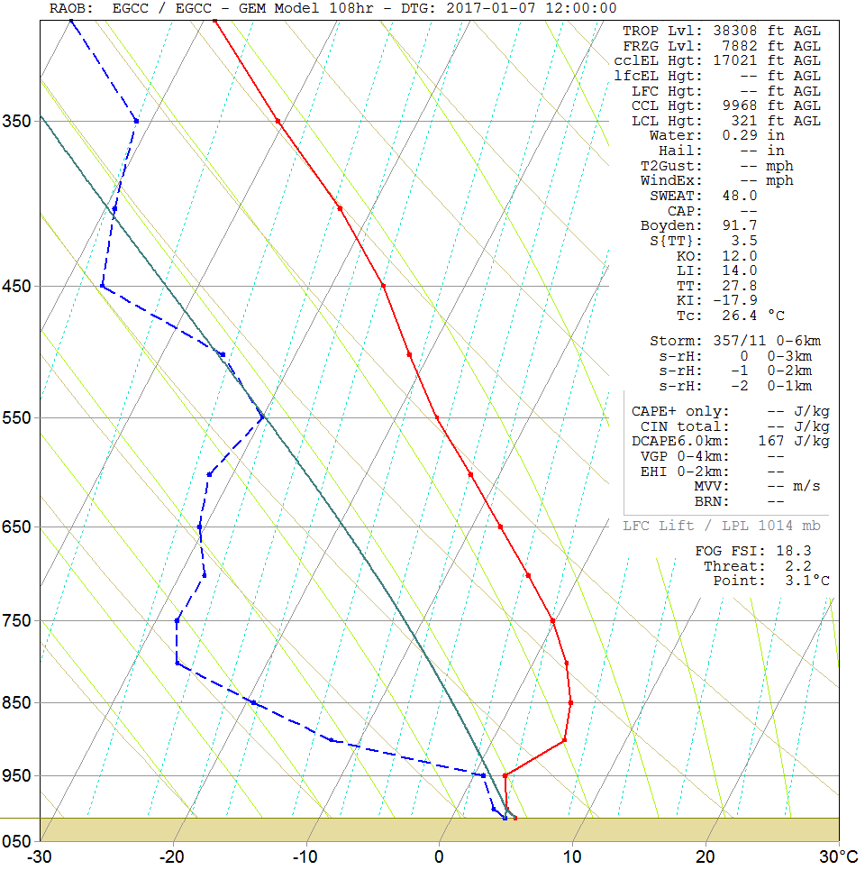
A forecast sounding for the 7th for Manchester highlights this general situation with regards to potential boundary layer issues. There is clearly marked subsidence in evidence (large spread between the air temp, red line and dew point, blue line) from 950mb up to the mid and upper atmosphere. However, within the boundary layer a smaller region of moisture does exist and this could well lead to more pronounced regions of shallow Cu or Sc cloud. Given the time of year then clearly the details of cloud amounts and distribution will be important to the potential development of fog over the weekend, which given a relatively mild air mass could well be possible.
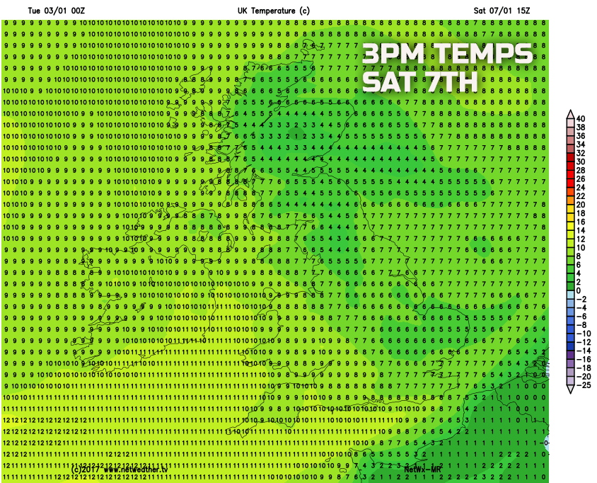
So, the coming week sees a drop in temperature and a clear and crisp air mass within the short term, as we move through Wednesday and into Thursday with a widespread frost across many areas to start Thursday. A more pronounced region of frontal systems brings some frontal rain to northern and western areas, in particular, to end the week, the only main precipitation event within the next five days. We then move into the coming weekend with boundary layer issues and uncertainties, but the emphasis is on further drier than average conditions and with wind directions generally being W’ly, off the N Atlantic. Then it will be relatively mild with temperatures near or slightly above average as shown by our medium range model for Saturday afternoon.
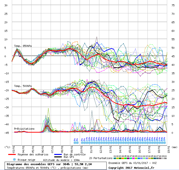
The conflicting signals that have plagued the medium and longer term so far this winter continue at the moment. There has and continues to be a signal within the GEFS for a drop in 850mb temperatures along with a more cyclonic pattern as well towards the middle of January. This could well lead to a heightened risk of wintry precipitation and colder conditions. However, the EC and its ENS haven’t really been supportive of this idea and indeed the 00Z EC Clusters highlight little risk of colder weather within the longer term with a more general zonal pattern developing across the UK but with short-lived colder intervals from the W or NW.
It is yet to be seen how the rest of January will pan out, but one thing does seem to have high confidence, and that is the chance of any sustained significant cold and wintry conditions within the next 7 to 14 days looks unlikely. Just highlighting this potential drop in 850mb temperatures though is the 00Z GFS ENS, but uncertainties continue…