In the latest synoptic guidance blog, Matt looks ahead to a more a more settled period ahead of a change to colder weather to start the New Year.
Issued at 1500GMT on Tuesday 27th Dec based on 27th Dec 00Z Model Runs
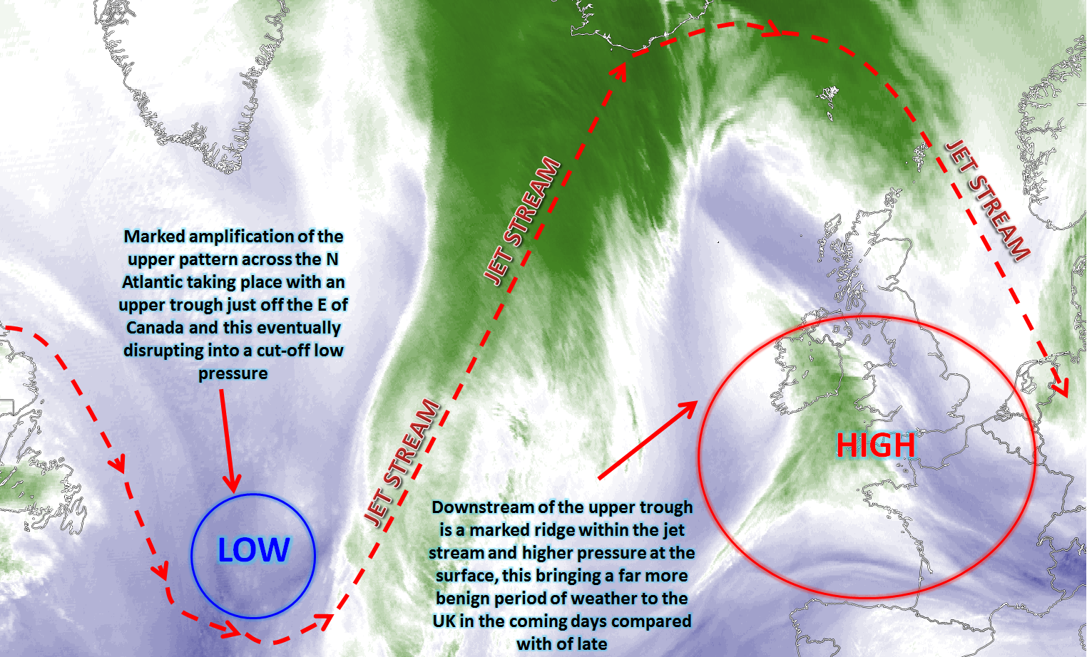
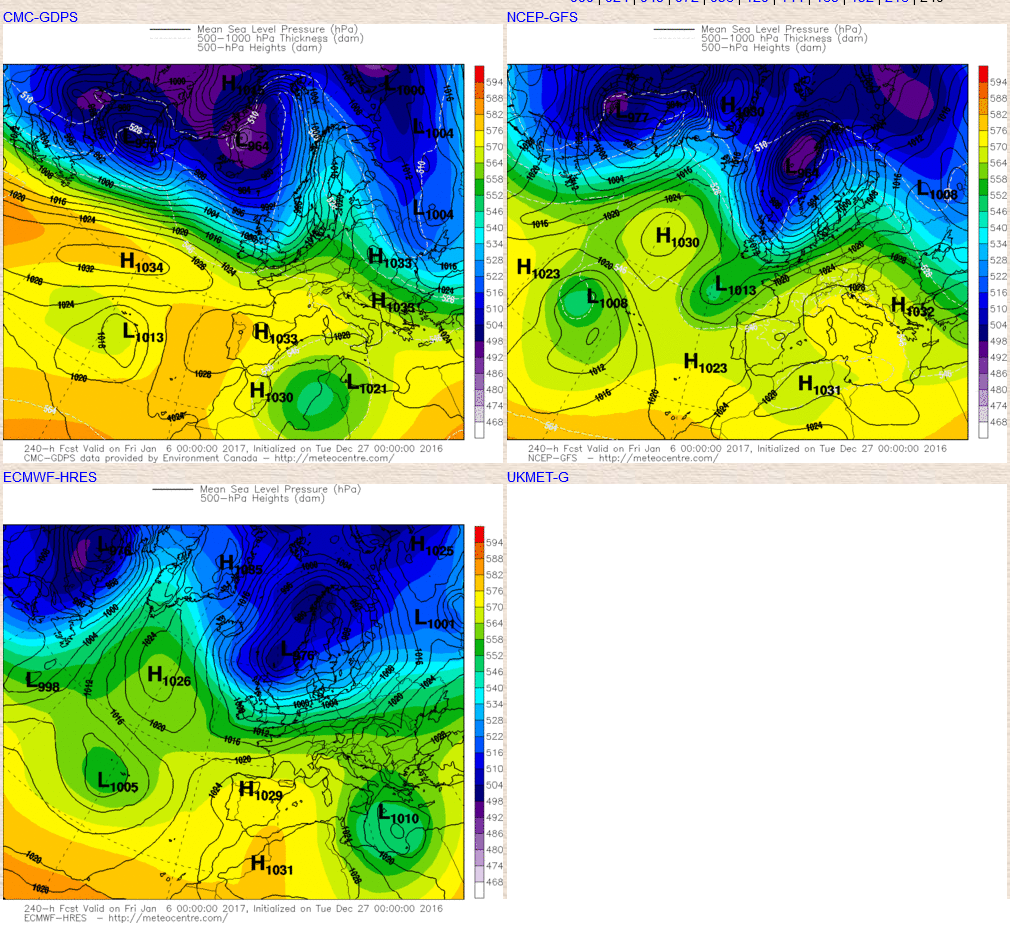
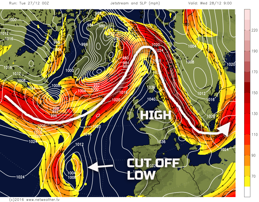
Wed 28th: As we move into Wednesday and model agreement continues to be good with the GEM, GFS, EC, UKMO and JMA all showing a large amplification of the upper pattern across the N Atlantic. An upper trough just to the E of Canada is expected to disrupt into Wednesday forming a cut-off low pressure near to the Azores. However, across the N Atlantic and NW Europe in general, the amplification to the pattern means the jet stream will be well to the north of the UK, as far north as N Scandinavia. Beneath this will be a large area of high pressure, central pressure from most of the models is over 1040mb, and this is what will dominate the weather through the day.
A cold start is expected, especially across England and Wales with frost, fog and perhaps freezing fog patches too. The centre of gravity of the high pressure will be over the near Continent with the UKMO, GFS, GEM and ECMWF, for example, all showing an intense area of high pressure with pressure rising to around 1045mb as Wednesday progresses. Given that the high pressure will be to the SE though then around the north and west periphery of the high pressure a milder, cloudier air mass will dominate and this will affect Scotland and Ireland in particular. It is here that more extensive Sc cloud will dominate through the day, with weak fronts perhaps bringing some patchy drizzle too and with more of a Tm air mass to the flow it will, generally, be milder across northern and western areas through the day. The GFS model highlights this significant amplification of the pattern, especially compared with the strong zonal flow that has just dominated prior to Christmas.
Thu 29th: As we progress through into Thursday and the broader synoptic patterns don’t change. The large area of high pressure that will be centred just to the south-east of the UK will continue to dominate across the UK, but still with more of a SW’ly flow across northern and western areas of the UK around the periphery of the high pressure.
The jet stream will remain well to the north of the UK and this will bring a particularly disturbed period of weather to Iceland and more central and northern areas of Scandinavia where a particularly mild SW’ly air flow will be in evidence over the top of the blocking area of high pressure.
The general weather conditions across the UK will be particularly benign though with England and Wales in particular dry with some bright or sunny spells after another cold and frosty start with some mist and fog too. For Scotland and Ireland, perhaps the far north of England too, then more of a SW’ly breeze will continue to signal milder conditions here, along with more cloud too and with an on-going risk of some patchy light rain or drizzle, perhaps especially so across W Scotland where some orographic enhancement may come into play in association with the Tm SW’ly air flow.
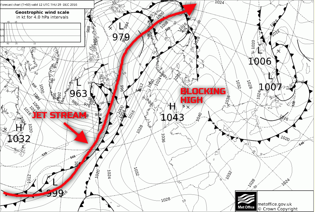
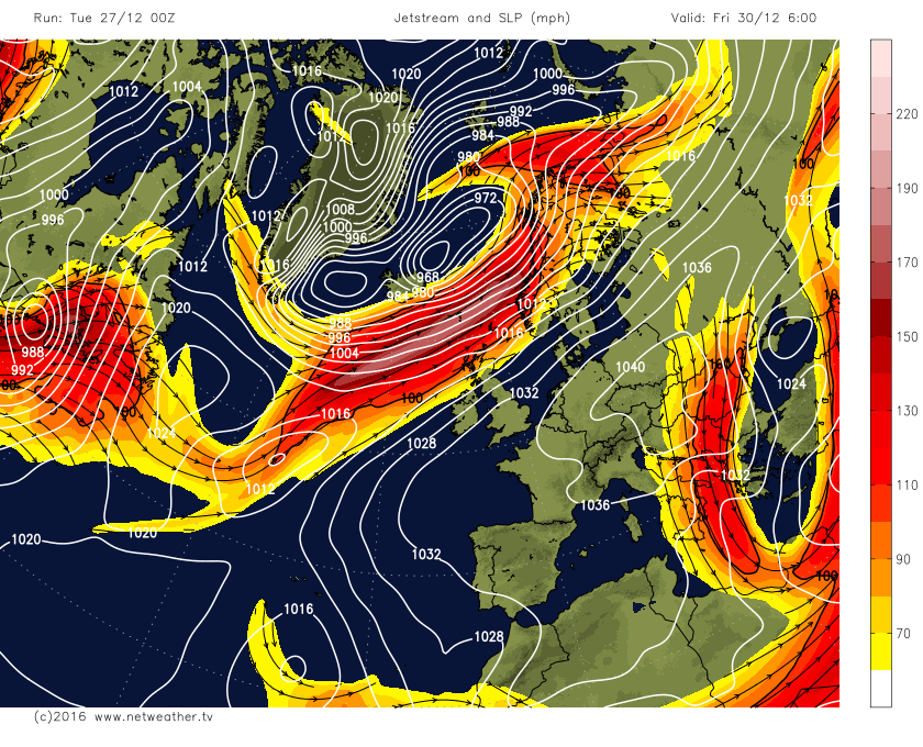
The UKMO FAX chart does a good job of highlighting the broader patterns and I’ve overlaid the jet stream to highlight how the blocking high pressure will be deflecting low pressure systems well to the north of the UK generally. It should be highlighted to that by Thursday there could well be a large variation in maximum temperature across the UK with much higher Tmax across Scotland than compared with England and Wales. Highs in excess of 10C may well develop across parts of Scotland, but across England and Wales temperatures may struggle to just 2C or 3C, especially where any mist or fog lingers.
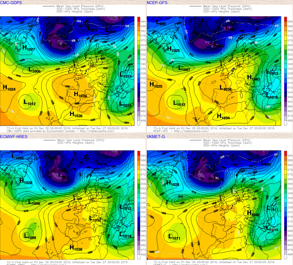
Fri 30th: The week ends with high pressure still dominating just to the south and south-east of the UK, whilst lower pressure continues to track to the north of the UK over the top of the high pressure and overall there is good agreement from the ECM, GFS, GEM and UKMO, along with the ENS for this pattern to persist. Most models, however, do show more of an active frontal system moving into parts of N Scotland during the day, perhaps with some frontal wave development possible. This front does look to be relatively well forced and, as a result, the forecast models do indicate a greater risk of more significant frontal rain across central and northern Scotland during Friday along with quite a strong W or SW’ly wind, but not to the extent of late.
The further south one progresses across the UK then the flow is still anticyclonic with atmospheric pressure across England and Wales still in excess of 1030mb, as things stand, during the day. There may well be more of a SW’ly component to the flow though even across England and Wales by Friday, and this may well lead to boundary layer being mixed than compared with previous days, so milder temperatures m ay well develop across England and Wales by the end of the week.
It should be highlighted though that there will continue to be a disconnect between 850mb temperatures for example and those at the surface. 850mb temperatures are forecast to be in excess of +5C across most of the UK, but maximum temperatures at the surface will still generally be lower than these values would correspond to.
The GEM, UKMO, GFS and ECMWF all highlight this general pattern for Friday quite well, noting the more anticyclonic flow still across England and Wales given closer proximity to the main high pressure over in the near Continent.
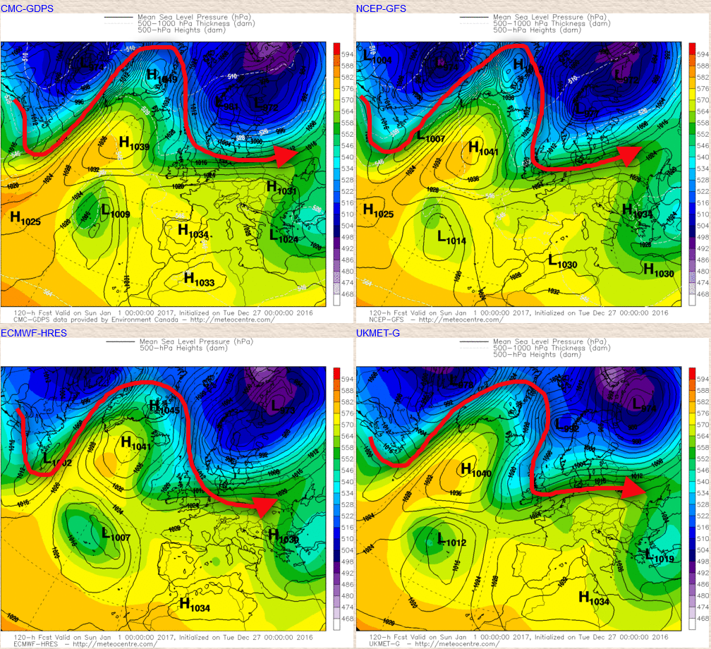
New Year’s Eve and New Year’s Day: As we progress towards New Year’s Eve and New Year’s Day we start to see a developing pattern that will eventually lead to the first Am (Arctic Maritime) outbreak of the season across the UK. The pattern that develops is generally one of retrogression and is aided by the development of higher pressure over the far west of the N Atlantic and also trough extension over NE USA and E Canada that allows warm air advection to occur.
What begins to develop through the 31st is for the high pressure over the near Continent to still dominate to bring mainly fine and settled conditions to England and Wales, but importantly there is an amplification of the pattern once again, which this time is to the west and north-west of the UK. That allows a more blocked regime to develop within the N Atlantic.
This can be seen in the animation below. Of importance through the sequence is the region of high pressure that emerges out of E Canada and is then followed by cyclogenesis over E Canada that creates warm air advection on the western side of the high pressure of which in turn then allows the jet stream to ridge northwards towards Greenland in conjunction with higher pressure at the surface.
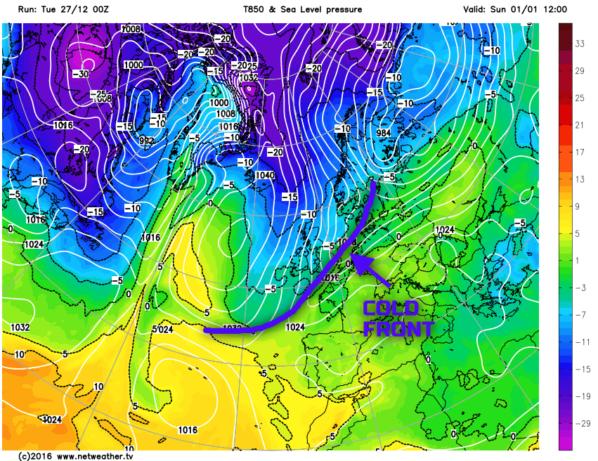
What this does then is allows for a colder Am air mass, the first ‘true’ N’ly outbreak to arrive from the north as we move into New Year’s Day. There is likely to be some sort of cold front moving southwards during New Year’s Day marking the boundary between the Am air mass coming southwards and somewhat less cold conditions ahead of it. The timing of this cold front is somewhat uncertain at this stage, but a zone of wet weather will move southwards across the UK during New Year’s Day and may well turn to snow on the back edge as the colder air digs in from the north.
We then see a likely mixture of clearer spells and snow showers developing across more northern areas of the UK during the second half of New Year’s Day especially those areas of the UK that are exposed to a N’ly flow. The broader pattern is highlighted well by the UKMO, GEM, GFS and ECMWF, noting the amplification to the west and north-west of the UK as we move into New Year’s Day.
So, the New Year is set to start on a cold and wintry theme as a band of rain moving southwards clears to then wintry showers. The air mass looks sufficiently cold enough to bring snow showers down to sea level across the north of the UK, but to what extent at this range is uncertain. Highlighting this progression towards colder weather is the GFS model with 850mb temperatures falling between -5C and -10C across the northern half of the UK as New Year’s Day progresses behind the southward moving cold front, so a taste of winter develops for all as we start 2017 with the coldest air mass of the season so far moving down into the UK from the north with, a possibility of 850mb temperatures nearing -10C across Scotland in particular by the end of New Year’s Day.
Where we progress from after that is uncertain.
Colder weather certainly looks set to dominate into the 2nd and 3rd at the moment, but the ridge to the west and north-west is unlikely to be a sustained one with it breaking down allowing for less cold conditions to arrive from the west and north-west. There is some evidence within the longer range models and data for the pattern to re-develop as we progress into the opening week or more of January though.
High pressure may well be a feature to the west and north-west of the UK generally and this may well then lead to a return to ridge amplification with colder N or NW’ly winds developing. The 00Z ECM model highlights this well, but in contrast and as a comparison is the GEM model, which produces a more unsettled regime with less amplification to the pattern. The likes of the EC monthly and other data does suggest that colder outbreaks from a northerly direction are possible as early January progresses, but in what is an uncertain and developmental period, confidence beyond the colder weather for New Year is low.