A very unsettled period of weather leading up to, and into Christmas, potentially calming down from Boxing Day though.
Issued at 1500GMT on Tuesday 20th Dec based on 20th Dec 00Z Model Runs
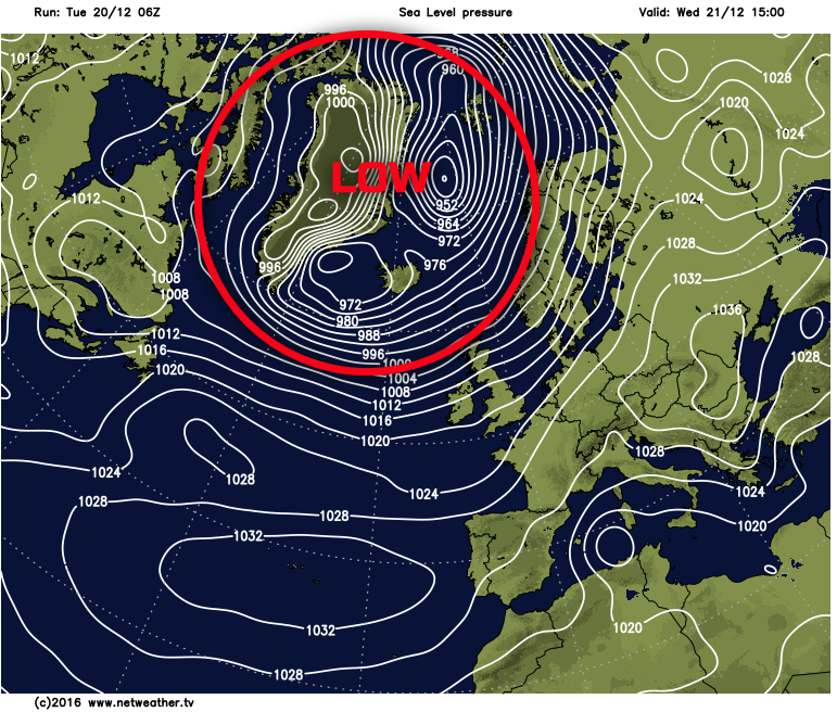
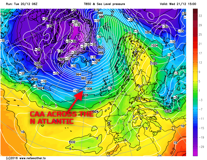
Wed 21st: As we move into Wednesday and model agreement continues to be good with the GEM, GFS, EC, UKMO and JMA all showing a large area of low pressure, in association with the tropospheric polar vortex, to the north and north-west of the UK. With higher pressure to the south and south-east of the UK a distinct +ve NAO pattern is likely across the N Atlantic through the day. The overnight frontal systems in association with Tuesday’s low pressure will be in evidence first thing across central and southern areas of England and Wales, so a cloudy and wet start here.
The ARPEGE, UKMO, ECMWF and some other HRES models indicating the potential for frontal wave development along the residual frontal zones through the day. As a result for more southern and south-eastern areas of England then Wednesday is likely to be overcast and wet throughout most of the day, so a particularly poor day of weather is expected here with frontal rain not clearing to the far south-east until very late in the day. For many northern and western areas of the UK Wednesday will be a cold day as a strong PGF will advect cold air, originally from Arctic Canada, across the N Atlantic and into many northern and western areas. This regime will bring about maritime based convection with many parts of Scotland and Ireland seeing sunshine and blustery showers through the day. The air mass will be sufficiently cold enough to allow for wintry precipitation, especially above 250m to 300m across Scotland in particular. Showers will be fewer and farther between across N England and Wales and it is here that the best of the weather will be on Wednesday, so whilst windy and feeling cold it will be mainly dry with some sunshine. The below charts both highlighting this general broader synoptic evolution through the day.
Thu 22nd: As we progress through into Thursday and a more of a north and south divide in the weather develops through the course of the day. It could well be a cold start across England and Wales with possible frost given somewhat lighter winds here than further north. As Thursday progresses higher pressure will build in more southern areas of the UK. As a result, many central and southern areas of England and Wales have a fine day with some sunshine, but it will be chilly and a cold night may then also follow for parts of England and Wales. Across the northern half of the UK and a similar regime to Wednesday is expected. All the main forecast models indicating a continuation of a Pm air mass of which will be unstable to sea surface temperatures and with showers being driven along by a fresh or strong, possibly near gale force W’ly wind. The showers most frequent again across Scotland, N Ireland and perhaps N England and the showers will still be wintry too across higher ground of Scotland, especially above 200m with, by this time, some accumulations possible, whilst hail and sleet may well occur at lower levels.
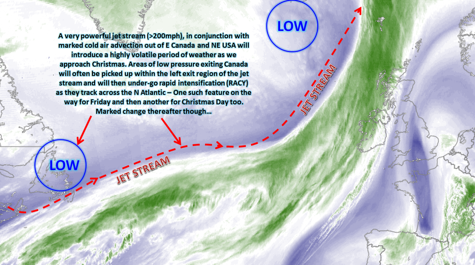
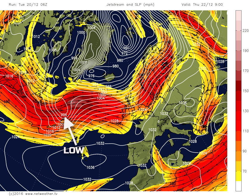
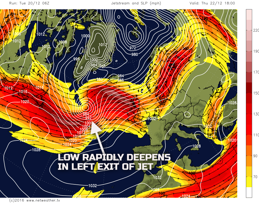
So, essentially a north and south divide is expected with high confidence, given good model agreement and consistency through the day. However, importantly we look upstream, across the N Atlantic, as an area of low pressure exits eastern Canada and will then be picked up by the strong jet stream to allow then for the initial developments of a low pressure that will bring some stormy weather to the end of the week. The low pressure will become located within the left exit, diffluent region of the jet stream, which is what will be the primary reason for rapid development, not only that but due to marked CAA into the rear of the system as well. The low pressure in question, along with the jet stream, can be seen below.
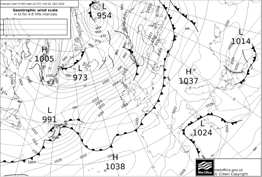
Fri 23rd: So we end the week with all eyes on the development of a very vigorous area of low pressure of which is likely to pass just to the north-west of Scotland through the course of the day. The midnight models by the end of Friday have the low pressure with a central pressure of 951mb (GEM), 948mb (GFS), 949mb (ARPEGE), 955mb (ECM) and 958mb (UKMO). This system has now already got a name and will become Storm Barbara through the course of the day.
Clearly, the weather associated with this system will be very unsettled. The weather may well start cold across some southern and eastern areas of England but rapidly conditions will deteriorate across Scotland and Ireland during the morning with severe gales developing, along with a zone of heavy rain, perhaps with some torrential downpours too. The winds will be a feature of the weather for the north and west with storm force gusts possible across more northern and western areas of Scotland. Perhaps with winds in excess of 80mph, but even across more populated parts of Scotland, Ireland, N England and Wales, gusts up to 50mph to 60mph are possible and this will lead to some very inclement conditions.
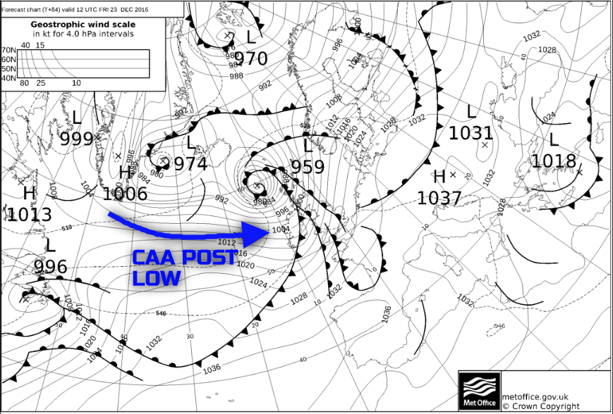
Wet and windy weather will eventually reach SE England later in the day and then quickly following on behind the system will be another region of CAA of with its origins again from Arctic Canada. As a result blustery showers, these turning increasingly wintry, will pack into many areas of Scotland, N Ireland and N England late in the day and with a marked wind-chill factor developing too. Highlighting this general evolution well is the overnight FAX charts from the UKMO. Note as well at 12Z Thu 22nd the surface low pressure is forecast to have a central pressure of 991mb, but by 12Z on Fri 23rd, as it is passing just to the north-west of the UK, the central pressure is down to 959mb, that is a drop over 32mb within 24 hours and most certainly a perfect example of RACY (Rapid Cyclogenesis). Note too, as annotated, the colder, convective air mass following the cold front from the north-west later on.
Xmas Eve and Xmas Day: Christmas Eve will see Friday’s deep low pressure system clear away to the north of the UK with the entire main 00Z GM’s indicating the clearing away to the north or north-east. The cold air advection following it its wake will lead to similar weather conditions to that of Thursday across the north of the UK with Christmas Eve a cold day for many, but especially across the north with sunshine and blustery showers, the showers locally heavy with hail and thunder and also wintry on higher ground. Instability will be far less significant across most of England and Wales and, as a result, any showers will be isolated here and overall a lot of dry weather is expected through Christmas Eve with some sunshine too, but again it will be chilly and quite a seasonal day. However, we then, again, look upstream for another developing area of low pressure.
This will bring a renewed period of highly cyclonic conditions across the UK overnight on Christmas Eve and into Christmas Day. There does remain some uncertainty over the details surrounding this system, but it is, to start with, likely to have a large warm sector associated with it. And as a result, Christmas Day, for most, is looking very mild despite a probable drop in temperature from the north-west later in the day as a cold front moves south-eastwards. The timing of the cold front, south-eastwards is uncertain mind and Christmas Day could well turn colder quicker from the north-west or equally it may yet still much milder for many until very late in the day. At the moment though the further north and west across the UK, you are then more quickly you are likely to see a Pm air mass return and with a significant drop in temperature through the second half of the day.
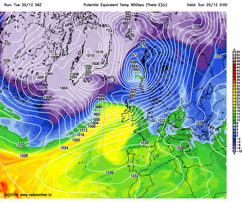
Many areas of the UK will be very windy once again, stormy conditions remain possible across the north of the UK in particular, with gales or severe gales again possible across Scotland especially. Showers following within the Pm air mass do look as though they will turn wintry across northern hills late in the day, but again the timing of the arrival of this colder air mass, post fronts, is still uncertain. Highlighting this general weather pattern through Christmas Day well is the latest GFS model, with MSLP and theta-e. Note that the low pressure potentially undergoes deepening to bring some very strong winds to the north again (very tightly packed isobars), but also note the much milder air mass, as represented by the yellow and green shadings moving across the UK. This then quickly being followed by a colder air mass from the north-west later in the day. It is the speed and development of the low pressure, along with the timing of the cold front south-eastwards that will determine just how quickly colder air returns across the UK after a very mild start to Christmas Day.
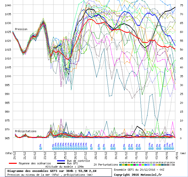
As we move into Boxing Day and then also into the beginning of next week, there has been a shift in output from the GM’s and especially from the ENS for a rapid build of pressure across the UK. As a result, at the moment at least, after some very unsettled conditions as we move towards and over the Christmas period, a rapid improvement in the weather is then likely from around Boxing Day onwards.
Depending on the finer details nearer the time higher pressure building over the UK may well couple with a relatively cold air mass to bring about a more settled, cold and frosty period of weather early next week. The 00Z GFS ENS for N England, as an example, highlight this rapid build of pressure as we progress through the 26th and 27th. There is a lot of scattering through the end of the month, regarding the overall pressure patterns. So confidence in the evolution is quite low, but the overall mean is for pressure to rise to near 1030mb by the 26th and the 27th, indicating this quick trend towards far more settled and benign conditions after Christmas.