The latest synoptic guidance blog - 13th December.
Issued at 1500GMT on Tuesday 13th Dec based on 13th Dec 00Z Model Runs
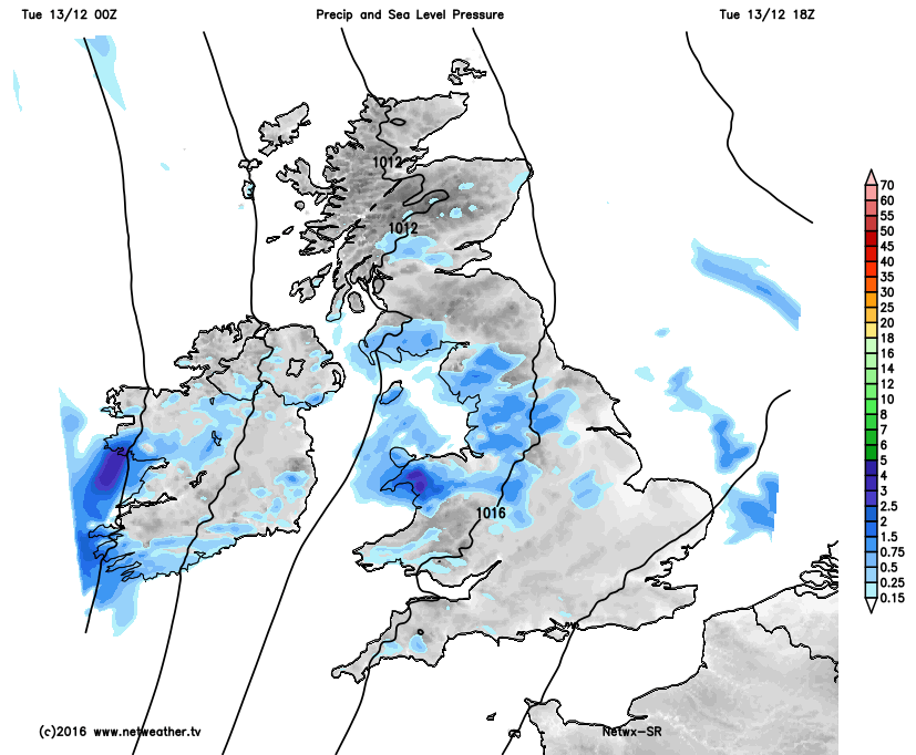
Rest of Tue: Forecast model agreement is good through the rest of Tuesday for relatively weak frontal systems to continue to bring rather sporadic regions of mainly light rain and drizzle northwards across the UK. The nature of the precipitation being highlighted well by some of the HRES models, including our own, but also the likes of the EURO4 and ARPEGE for example, with some differences in where these areas of precipitation will track through the rest of the day.
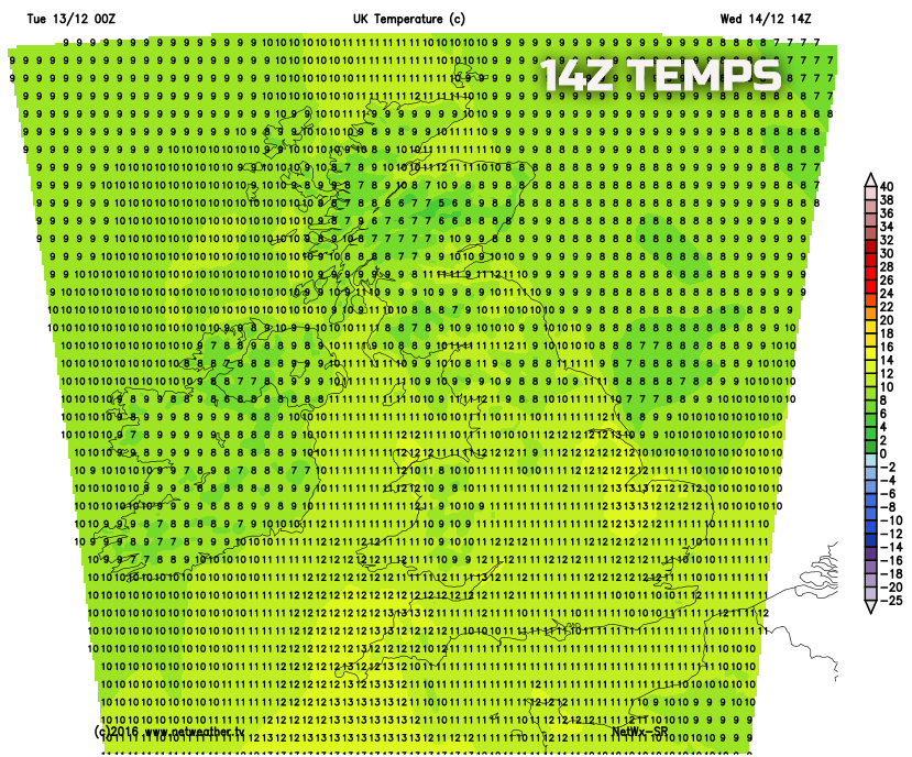
The meridional flow continues to maintain a general S or SW’ly air flow over the UK and through the remainder of Tuesday and into Wednesday will likely become the mildest period of the week across many areas of the UK with temperatures rising to slightly above or above average. But the overall air mass is not conducive to produce the high Tmax temperatures that occurred through the middle part of last week for example.
In-between the regions of precipitation drier and clearer conditions are to be expected, perhaps with some brighter intervals. Our HRES model gives a snapshot of the likely distribution of the precipitation this evening, perhaps with some focus for wet weather across parts of N Wales, NW England also across parts of Ireland too.
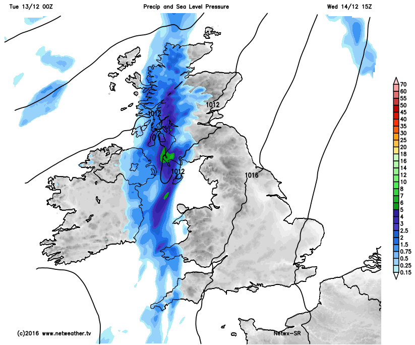
Wed 14th: As we move into Wednesday and model agreement continues to be good with the GEM, GFS, EC, UKMO and JMA all showing an area of low pressure, circa 986mb 00Z 14th, passing to the west and then north-west of the UK. Once again the meridional flow to the jet stream means that these systems are struggling to make much progress into the UK. However, confidence is high, given the good model agreement that the process through Wednesday will be for a cold front to move into most of Scotland and Ireland bringing outbreaks of light or moderate rain and showers. Forcing is relatively weak, but some heavier bursts of rain cannot be ruled out at times.
The S or SW’ly flow ahead of the surface front will maintain the relatively mild air mass across England and Wales, and here it is forecast to be predominantly dry too with some bright intervals and, given the combination of some sunshine and mild temperatures for the time of year, it will feel particularly pleasant. The wet weather is then likely to move far enough east to bring some rain into NW England, W Wales and SW England by evening. But the upper trough and forcing then becomes increasingly removed from the main surface fronts, so the precipitation rapidly fizzles out later on Wednesday, whilst skies clear behind across parts of Scotland and Ireland. Our HRES model, which is supported by other short range guidance, highlights this general evolution well through Wednesday, noting a lot of dry weather ahead of the surface front and also some mild and quite pleasant conditions too.
Thu 15th: As we progress through into Thursday and, overall, the broad model agreement between the various forecast models continues to be good. There are more in the way of mesoscale uncertainties across the UK regarding areas of light precipitation and cloud amounts, but generally, the overall forecast does have high confidence. A residual frontal zone, from Wednesday, is likely to be slow moving down the spine of the UK through the day. Some patchy light rain and drizzle are possible from this, but nothing more than nuisance value, but forecast soundings show a significant amount of moisture within the lower atmosphere. So Thursday is likely to be a much cloudier day across England and Wales than compared with Wednesday.
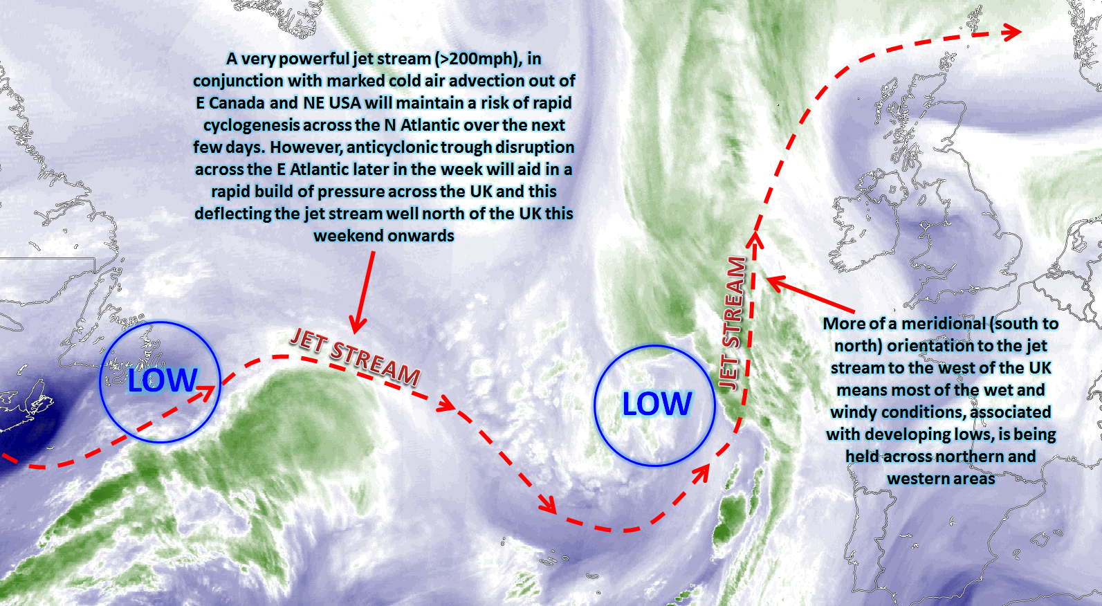
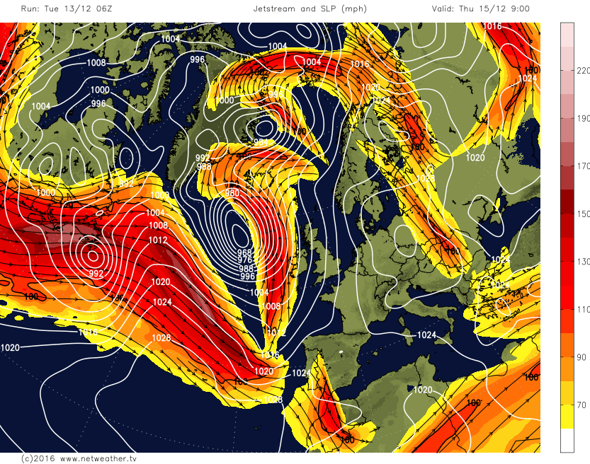
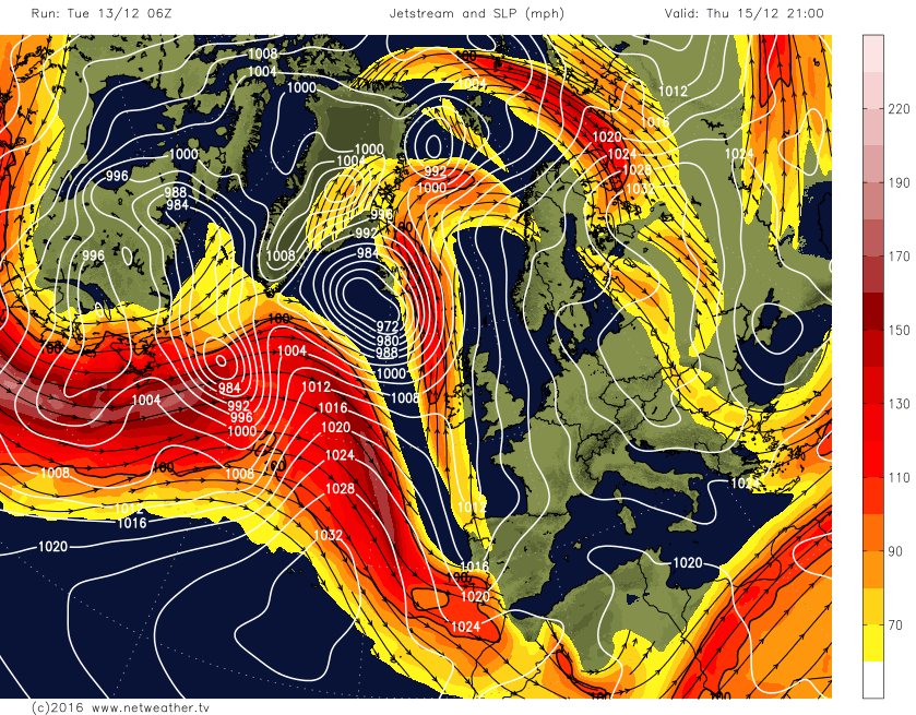
At the same time yet another area of low pressure, circa 966mb, will be passing to the north-west of the UK in association with the on-going developmental jet stream that dominates across the N Atlantic. The frontal system, a likely occluded front, associated with this low pressure will then move into western areas of the UK again through Thursday to bring further outbreaks of rain across parts of W Scotland and Ireland during the day. However, the blocking regime that continues to hold to the east of the UK will still mean that the overall upper-level pattern across the UK is meridional and with a general south to north flow. This means that, once again, the frontal zones will struggle to move eastwards across the UK and eventually the forcing associated with the front is removed and the precipitation becomes increasingly light across western areas of the UK into Thursday evening, with very little rain from the front getting into England and Wales.
This broader evolution is highlighted well by the MSLP and jet stream charts from the GFS model. Note how the surface low pressure develops significantly to the north-west of the UK through Thursday, but the general orientation of the jet is south to north.
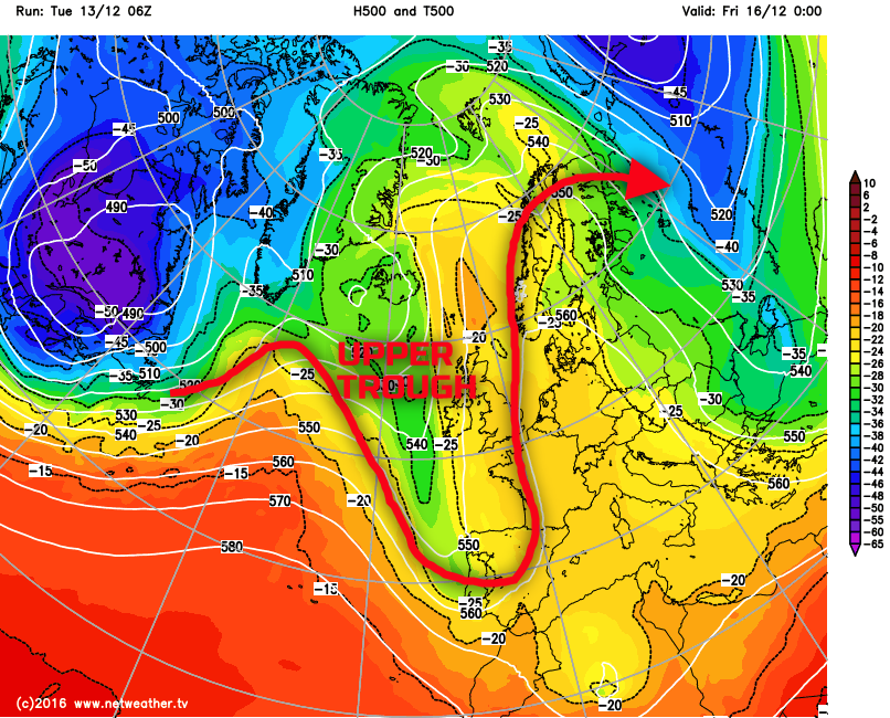
Fri 16th: We end the working week with the weather then undergoing a significant change across the UK. A large blocking area of high pressure that will continue to be in evidence to the east of the UK will join forces with a developing area of high pressure that quickly develops across the UK through the day and beyond after a process known as anticyclonic trough disruption takes place. An upper-level trough just to the west and south-west of the UK will undergo disruption with the main trough then becoming a cut-off low pressure over Iberia. This process then allows a rapid build of pressure across the neck of the trough where the disruption takes places, and this process is highlighted on the below charts.
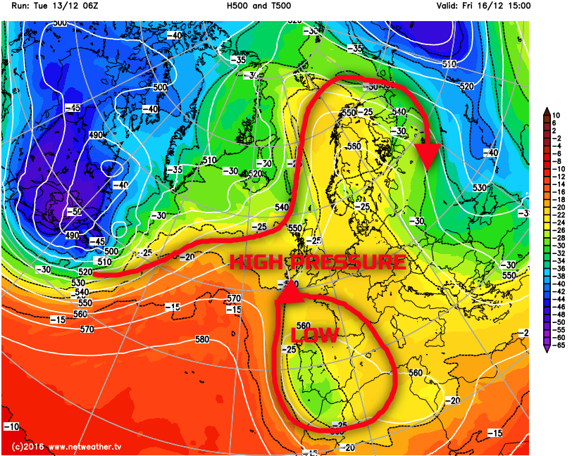
A weak frontal zone lying across the UK is likely to bring some patchy light rain and drizzle for a time during the day, perhaps especially so across parts of S Scotland, N England and Wales, but as the trough disruption takes place, then there will be an increasing amount of subsidence. As pressure rises across the UK and the front will essentially fizzle out across the UK with just residual cloud present. A cooler airmass will also likely follow into more northern and western areas during Friday too and with clearer skies here then the first widespread frost in quite some time may well develop across Scotland, Ireland and perhaps N England on Friday night. The animation below also highlights the process where the upper trough (blue region) to the west and south-west of the UK undergoes disruption with then a cut-off low pressure (blue region) declining down towards Iberia. Whilst higher pressure (red area) rapidly develops across the UK to signal the onset of a far more anticyclonic period of weather from Friday onwards.
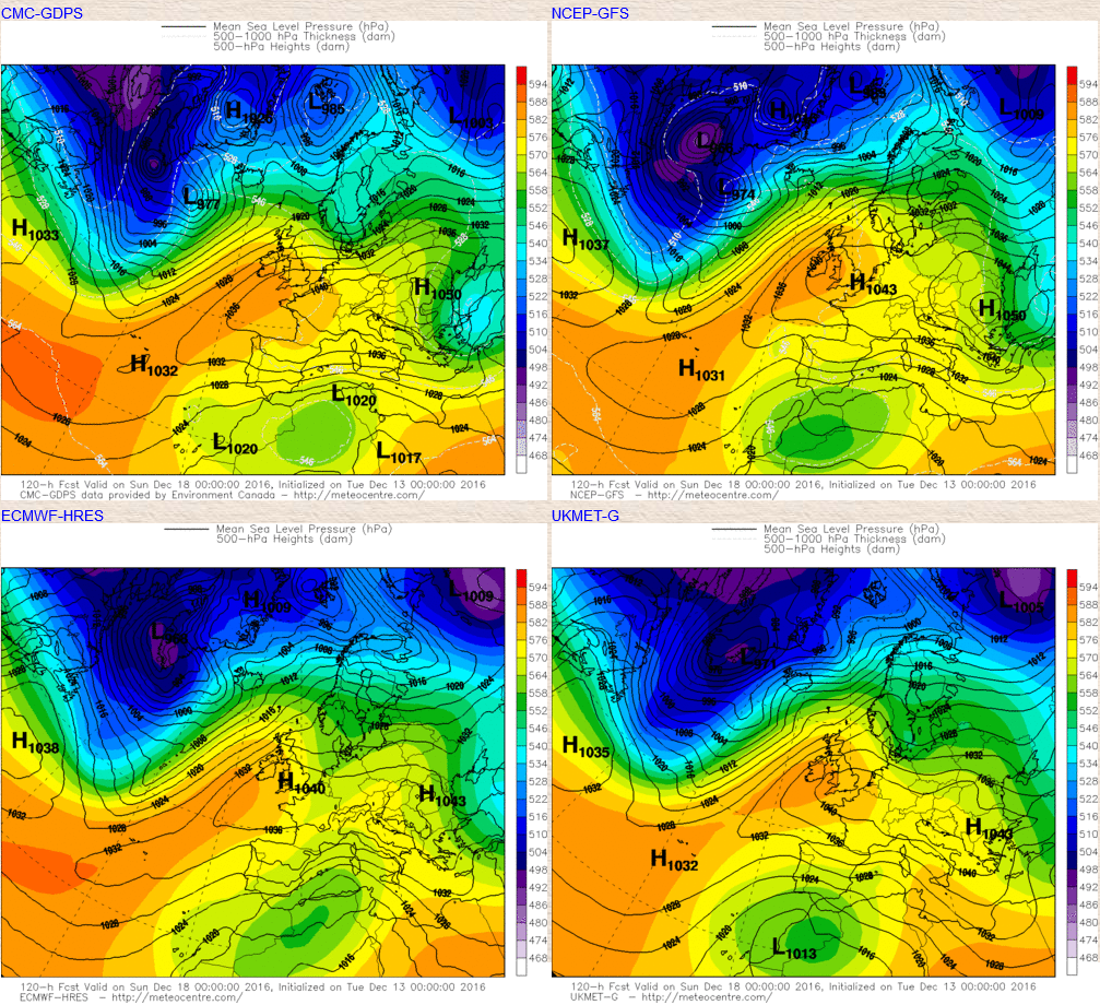
Sat 17th and Sun 18th: As we move into next weekend there is high confidence for high pressure to be dominating the weather across the UK, but the exact position of the centre of gravity of the high is still somewhat uncertain. This does bring with it difficulties in forecasting cloud amounts and whether a milder SW’ly air flow develops over the top of the high pressure to bring cloudier and milder conditions to Scotland and N Ireland for example. However, the consensus is for a 1035mb to 1040mb high pressure to be centred across England and Wales at the moment as the coming weekend progresses. As can be seen from the below GM’s the GEM model in particular would allow quite a mild W or SW’ly flow to develop over the top of the high, but in contrast the GFS model maintains a far more pronounced blocking pattern over most of the British Isles with any mild W or SW’ly being to the north of Scotland.
The overall weather patterns across the UK will be for a lot of areas to be dry and settled with some sunshine. Forecast soundings are problematic, and some do signal a lot of low-level moisture with perhaps extensive Sc or Cu leading to ‘anticyclonic gloom’. But with the exception of thicker cloud and perhaps some light precipitation across the far north of Scotland the weekend as a whole is likely to be dry, settled, colder than of late and perhaps with some overnight frost and fog, but to what extent is uncertain for now.
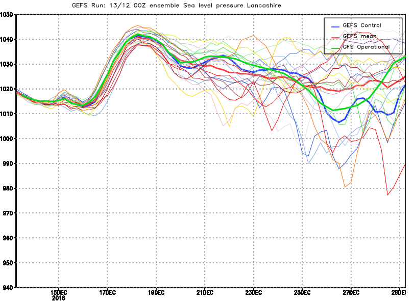
As we progress into next week and the blocking regime is forecast to be dominating earlier in the week at least. The week prior to Christmas then becomes more uncertain due to an on-going issue and discrepancy between the GFS ENS and the EC ENS in particular. The former has been quite consistent in maintaining the blocking pattern through most of next week and perhaps including the Christmas period, which would lead to a seasonal outlook with chilly temperatures and with overnight frost and fog.
However, the ECMWF and its ENS has been far more progressive of late and of which moves the main surface blocking high to the east and allows a milder and more unsettled W or SW’ly type to invade from the west as next week progresses. This has and continues to be an ongoing issue but it should be highlighted that it is the GFS ENS that has been quite consistent of late and the most recent update of the EC Monthly model, for example, also indicates a greater propensity for blocking conditions to be maintained through the rest of December and into early January. The 00Z GFS ENS below highlights this signal for blocking, chilly and seasonal conditions to last through next week and perhaps up to Christmas too, but more model runs are determined to see which model is ‘right’ in terms of whether a breakdown takes places prior to Christmas, as per the ECMWF, or whether a blocking regime is maintained, as per the GFS. As things stand I believe the blocking regime will contiunue through to the Christmas period, especially across England and Wales.