A milder, unsettled regime is in place for now, but there is a potential pattern change back to more blocked conditions after mid-month.
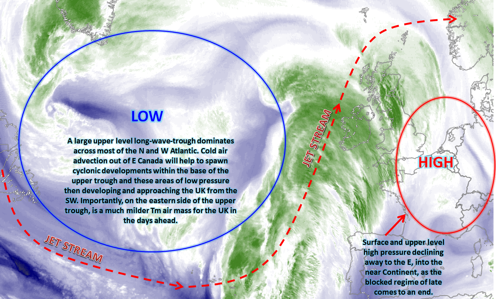
Rest of Tue: Forecast model agreement is good through the rest of Tuesday for a slow change away from the cold and blocked regime of late to a more cyclonic pattern as our blocking area of high pressure declines towards the east and south-east. A large scale long-wave-upper-trough within the N Atlantic will be the dominant feature in the coming days, but individual cyclonic developments within the base of the trough will bring areas of low pressure northwards towards the UK, approaching from the south-west. One such area of low pressure will track to the west of Ireland today, with all the main GM’s and HRES models in good agreement over this development. Frontal zones, quite well forced too, will move into many areas of Scotland and Ireland as the day progresses bringing outbreaks of rain with some locally heavy rainfall possible across W Scotland too, given a combination of active frontal zones combining with WAA to bring a risk of orographic enhancement. For most of England and Wales though the overall flow through the rest of the day is still anticyclonic rather than cyclonic, so whilst temperatures will continue to increase, many areas will be mainly dry. Overcast conditions will dominate though and as the warmer air mass moves over the chilled boundary layer than some extensive low cloud and hill fog is possible almost anywhere across the UK through the rest of the day with some particularly poor conditions at altitude and with some poor aviation conditions too. This broader synoptic pattern across the N Atlantic and into the UK is exampled well by the GFS model for later today, clearly noting how far south the jet stream is tracking in conjunction with the long wave trough.
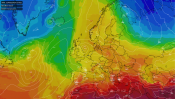
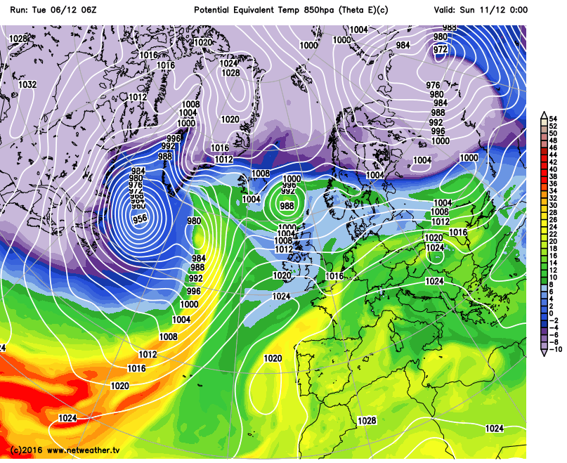
Wed 7th: As we move into Wednesday and model agreement continues to be good with the GEM, GFS, EC, UKMO and JMA all showing the blocking area of high pressure declining well to the east of the UK. The broader-scale upper trough remains in place to the west of the UK, and this combination of a large amplified pattern over the N Atlantic and into Europe means that the UK is on the eastern flank of the upper trough and, as a result, marked WAA will be taking place through the day. The theta-e animation below highlights this particularly well, clearly noting the yellow shadings moving up towards the UK in association with a marked thermal plume and this will mean the first of a few days with well above average temperatures across the UK, especially to the east of high ground with possible Fohn effects coming into place.
One area of low pressure is expected to be to the north-west of the UK, but an array of cyclonic developments will be taking place to the west and south-west of the UK with some frontal waves as well. Overall though and the general north and west, south and east split in conditions will continue. All areas of the UK will be milder by Wednesday, so that will be a uniform development with much higher temperatures and Td’s than compared with of late. However, the main frontal zone activity will continue to be across Scotland and Ireland, and it is here that outbreaks of rain and drizzle are likely, at times, throughout the day but with perhaps some marked rain-shadow effects taking place to the east of Scotland where it could well be markedly drier than the western upslopes of Scotland, for example. A fresh or strong SW’ly wind is expected across many northern and western areas of the UK too. Most of England and Wales, but especially central, southern and eastern areas, will still maintain a lot of dry weather with some cloud breaks too allowing for some bright or sunny intervals to develop. These brighter conditions then combine with higher temperatures to lead to a markedly different ‘feel’ to the weather across England and Wales than compared with the last several days.
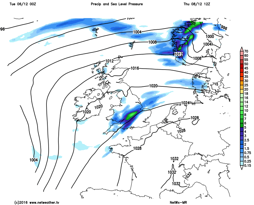
Thu 8th: As we progress through the end of the week and confidence regarding the details becomes quite low given that a number of individual cyclonic developments are possible that may well bring regional differences when it comes to the weather. Taking Thursday, to start with, and there is some agreement from the UKMO, EC, GFS and GEM models for a frontal wave to move across parts of England and Wales during the day. Clearly this development is likely to lead to a more organised region of rain moving eastwards across England and Wales for a time during the day, perhaps especially so during the morning before clearing away to the east through the afternoon. This feature can be seen on the below charts from our medium range model.
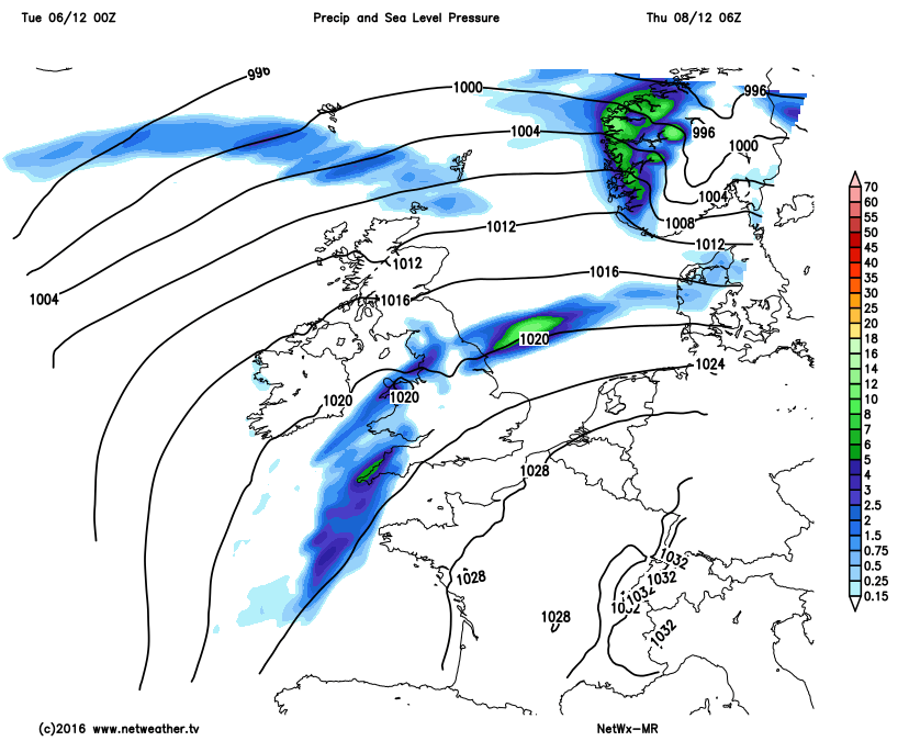
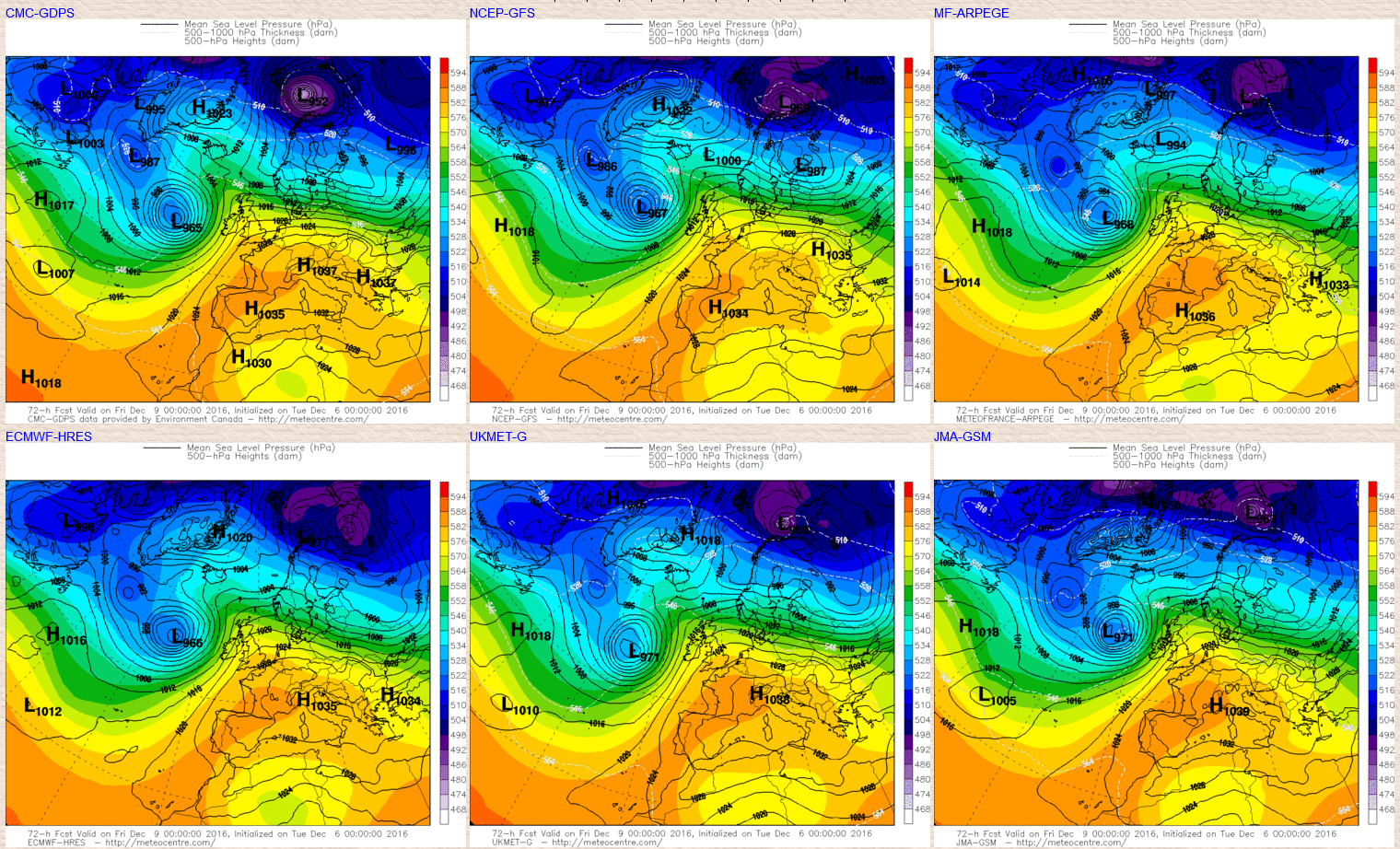
As this feature clears there is then a temporary build in pressure ahead of an area of low pressure developing and approaching from the south-west. As a result Thursday is likely to produce more in the way of drier and brighter conditions, once this potential frontal wave clears away to the east. Scotland and Ireland in particular will likely see a marked improvement in the weather than compared with the previous few days with more in the way of drier and sunnier conditions. However, confidence is medium too high to suggest that this improvement in the weather won’t last because arriving from the south-west will be quite a deep area of low pressure to end the working week. Fortunately it looks like this low pressure won’t directly move across the UK, but the GEM, GFS, ARPEGE, UKMO, ECMWF and the JMA all show a low pressure with a central pressure of around 970mb, or perhaps slightly lower, tracking to the west of Ireland later in the day.
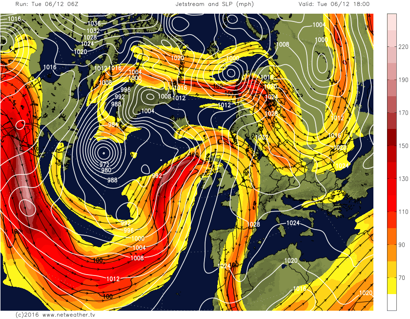
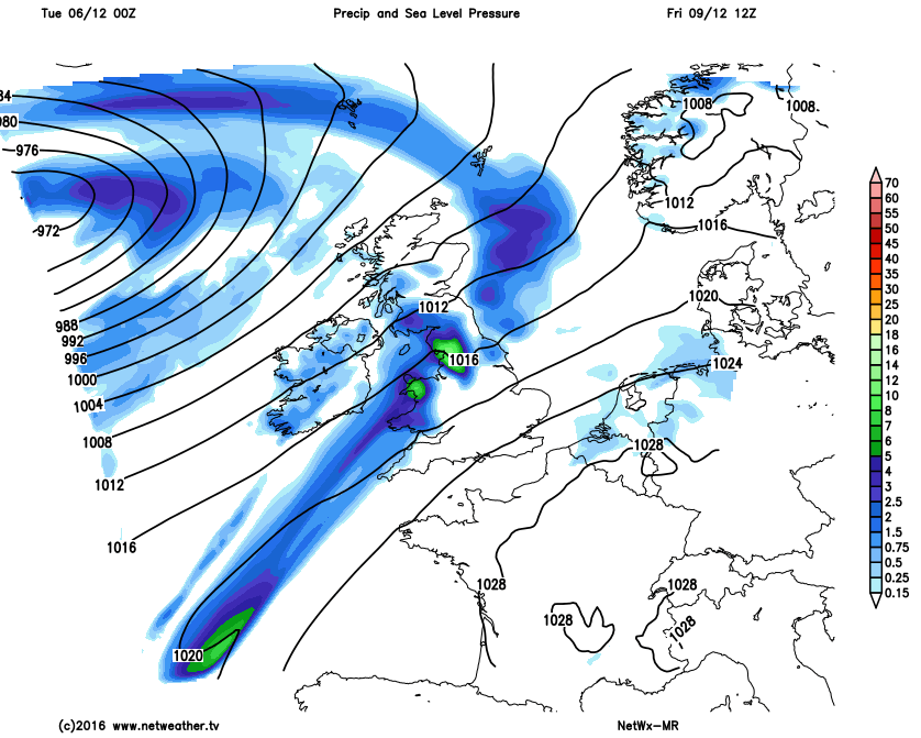
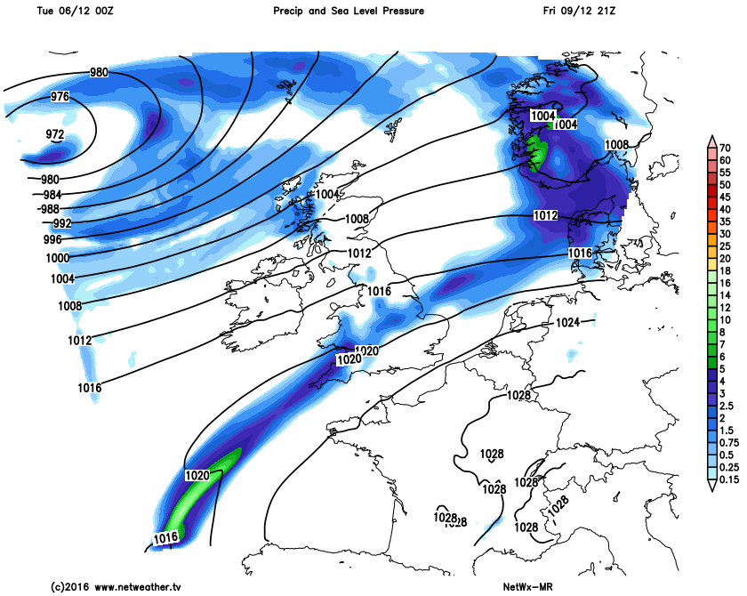
Fri 9th: We end the working week then with this deep area of low pressure tracking to the north-west of Scotland during the day on Friday. As a result after the very brief window of better weather for the north and west of the UK on Thursday, confidence is quite high to suggest Friday will produce a spell of wet and windy conditions across Scotland, Ireland and N England in particular. There is some uncertainty over whether the upper trough will overrun the surface fronts or not to essentially lead to a weakening set of frontal zones moving eastwards across the UK, but ignoring this level of detail for now, Scotland, Ireland and N England will be wet and windy on Friday but with a clearance to showery conditions then likely later. Whilst dry across Wales and the rest of England for a time, even here some rain and showers will likely move through, through the course of the afternoon and into the evening before clearing away to the east later. A strong or perhaps near gale force SW’ly wind is likely across Scotland and Ireland during the day, so a windy day especially compared with of late, our medium range model highlights this general evolution for Friday, noting the main feature of interest being the deep low tracking to the north-west and the close proximity of the isobars.
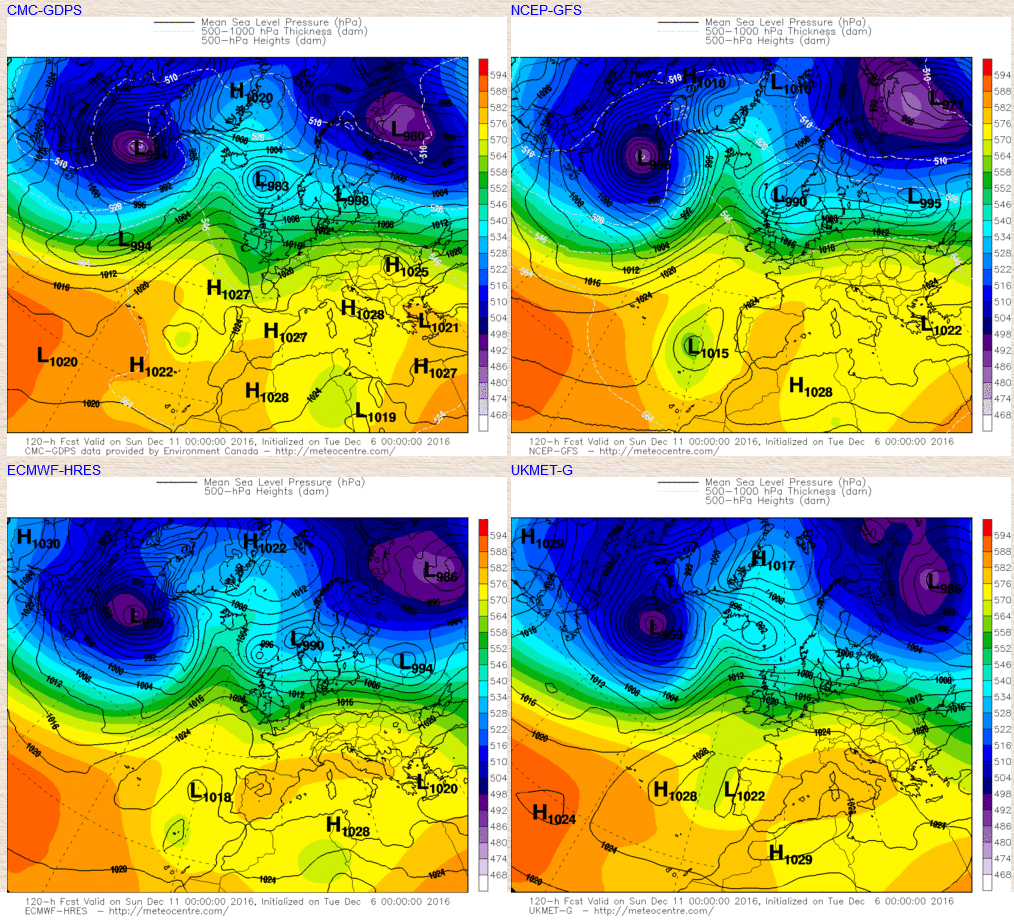
Sat 10th and Sun 11th: As we move into next weekend and there is some level of confidence for Friday’s deep area of low pressure to pass to the north of the UK through the course of Saturday and into Sunday, with a transient ridge of high pressure following from the west. This development is likely to lead to the mild or very mild SW’ly Tm air mass being cut off as more of a W or NW’ly air mass develops across the UK so there is reasonable confidence for a return to nearer average temperatures as next weekend progresses. The details regarding the weather are, however, somewhat uncertain as things stand. The low pressure will likely lead to a mixture of sunshine and blustery showers across the north on Saturday, whilst a potential trailing frontal zone brings wet weather to southern and south-eastern areas of England before clearing later. The transient ridge of high pressure is then likely to bring a more settled and somewhat colder across most areas on Saturday night, but winds are still likely to be too strong for any widespread frosts. Further frontal systems may well then return into some northern and western areas later on Sunday, but for now that particular development is very uncertain. The main GM’s at 00Z on the 11th highlight the general broader synoptic pattern as discussed.
Highlighting this change to a colder air mass too to at least bring temperatures back down to nearer average is the theta-e chart from the GFS for later on Saturday. When compared with the earlier discussed animation, which shows the much milder air mass for the next few days, the green and light blue shadings for late Saturday and into Sunday show this likely cooling trend with more seasonal temperatures returning for most.
There is and continues to be a lot of interest over the medium and longer term as we progress towards the mid-month and indeed towards Christmas too. There has been a lot of model volatility of late due to a number of reasons, but there is now some developing signs and signals that point towards the re-development of a more blocked pattern across the UK and NW Europe in general as we look towards and beyond mid-month. Confidence levels are, however, quite low given this model volatility and any real lack of consistency over one signal over a number of days. However, the way I see the evolution progressing at the moment is for the likely return of higher pressure over the UK, within the longer term, after this more unsettled and changeable period of weather within the short-term. It is all about model consistency now, especially from the likes of the GEFS and EC EPS when moving forward to see whether these developing signals of a more blocked regime will return. Confidence regarding any significant cold spell is low or very low and that, overall, shouldn’t be looked for at the moment, it is case of seeing what broader weather patterns may evolve first as we move towards the Christmas period.
However, as things stand I do believe that a return to potentially colder and drier conditions, overall, will develop looking forward in association with a blocking area of high pressure and this is now highlighted by 11-15 day ENS, including the NAEFS, GFS ENS, GFS (Bias Corrected) and GEM ENS as below. What is needed now is consistency moving forward, in the coming days that this pattern will indeed re-develop and we don’t see any further larger scale changes in the synoptic guidance for the longer term. If this blocking signal is indeed lost once again in the coming days, then the evolution really will be very uncertain, but there are tentative signs that at least a return to potentially similar conditions of late (cold and dry) may dominate the approach to Christmas this year and perhaps last through the Christmas period too.
.png)