
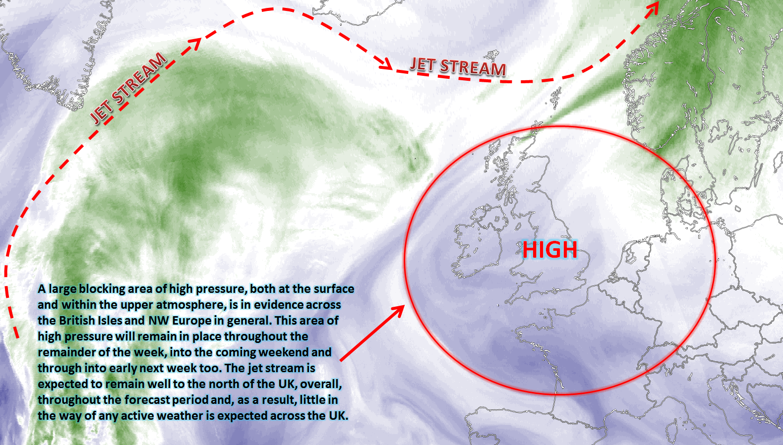
Blocking weather patterns continue as Autumn ends and Winter begins.
Issued at 1500GMT on Tuesday 29th Nov based on 29th Nov 00Z Model Runs
Rest of Tue
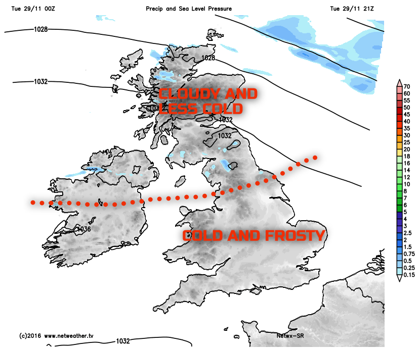
Forecast model agreement is good through the rest of Tuesday for many areas of the UK to maintain fine and settled conditions after a cold or very cold start with minimum temperatures several degrees below freezing in some instance this morning. The position of the high pressure is as such that more of a maritime airflow will develop over the top of the high pressure affecting Scotland initially through the rest of the day. Equally, a weak frontal zone, associated with lower pressure to the north of the UK, will also move down into Scotland to essentially bring thicker frontal cloud through the rest of the day, with some light rain or showers. The forcing associated with the front though will be particularly weak as the front moves into a region of subsidence associated with the blocking pattern over most of the UK. Good model agreement for unbroken sunshine for most of England and Wales too throughout the rest of the day, but cloud generally increasing across N England later on. Quickly turning cold again this evening and overnight for many central and southern areas of England and all HRES models signal another very cold night tonight from roughly the Midlands southwards, along with some mist and fog patches too. It will be less cold further north given more cloud, but patchy frost is still possible across N Ireland and N England but is unlikely across Scotland in correlation with a W or WNW’ly wind, thicker cloud and with some showers in the far north and west of Scotland too.
Wed 30th:
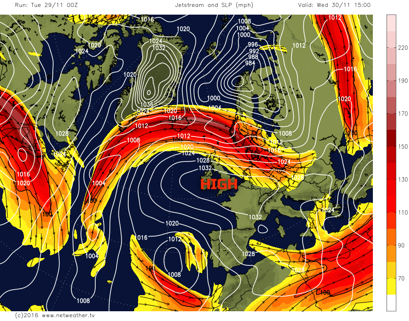
As we move into Wednesday and model agreement continues to be good with the GEM, GFS, ARPEGE, EC, UKMO and JMA all showing a large area of high pressure dominating the weather. With the main centre of gravity of the high being over Ireland, Wales and SW England with a central pressure of around 1036mb. The jet stream will be passing over the top of the high pressure, and there is good agreement for quite an active low pressure to be moving eastwards to the north of the Scotland. As a result more of a W or NW’ly airflow will have developed across most areas by Wednesday and this will introduce a somewhat milder maritime air mass and also more cloud too, especially from N England northwards. There will be a noticeable W or NW’ly wind across N Scotland too, potentially quite strong as most HRES model indicates which will be in contrast to the rest of the UK.
The clearer and colder air mass will still likely be in evidence across southern areas of England and Wales, beneath the main centre of the high pressure and it will be another very cold start here. Overall, there is expected to be little in the way of any active weather to speak of, but the emphasis is on more northern and western areas of the UK having a cloudier and milder day, but with the colder and sunnier regime hanging on across southern regions of England.
Thu 1st and Fri 2nd:
As we progress through the end of the week and into the opening days of December and, for many, the anticyclonic conditions will continue. The cloudier and less cold air mass will likely be in place across all areas during Thursday and, overall it will be a milder start too with far less in the way of frost. The cloud may well be thick enough for some patchy light rain or drizzle across western upslopes of Scotland and N England, but this will be the exception to the rule and, overall, the emphasis is most certainly on the dry weather being maintained from all of the forecast models.
The devil is most certainly in the details with regards to areas of Sc and Cu that will develop and move around beneath the area of high pressure. However, with somewhat lower GPH than earlier in the week, the boundary layer is forecast to be slightly more conducive to cloud development and, again, this supports a generally cloudier day for many areas of the UK. That being said a widespread region of Sc leading to ‘anticyclonic gloom’ is not expected, and there will still be some cloud breaks, especially the lee of high ground.
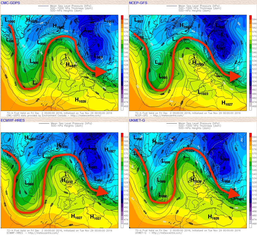
Trough extension across the west of the N Atlantic during Friday will start to mean ridge amplification takes place downstream, over the UK. As a result, the area of high pressure will start to orientate and become more directly located over the UK again by Friday and then more particularly into next weekend, essentially cutting off the maritime flow over the top of the high pressure. This process means that temperatures will start to fall away slightly during Friday than in comparison to Thursday. The overall weather type across the UK though won’t change, and there is, again, little in the way of active weather to speak of with many areas ending the working week dry with fine and benign conditions, variable regions of Sc or ScCu type-clouds but with some cloud breaks allowing for some sunshine too. This general amplified pattern across the N Atlantic, including highlighting our blocking regime, is evident on the ‘main four’ GM’s with the general track of the jet stream highlighted.
Sat 3rd and Sun 4th:
As we move into next weekend and there is high confidence that anticyclonic conditions will continue across all areas of the UK. The main area of high pressure is signalled to decline to the east and south-east of the UK as the weekend progresses, the GEM, UKMO, ECM and GFS all show this evolution taking place. One thing that does have high confidence is that further dry weather will dominate across many areas of the UK, with below or well below average precipitation totals compared with the average for the time of year. There are some uncertainties over cloud amounts and distribution, but what is likely to happen is that the declining area of high pressure will likely lead to more of an E or SE’ly airflow off the near Continent as the weekend progresses. As a result, there is reasonable confidence to suggest that a repeat of the conditions that are occurring now will re-develop as next weekend progresses, with drier and lower Td air moving into the UK off the Continent, but especially so across England and Wales.
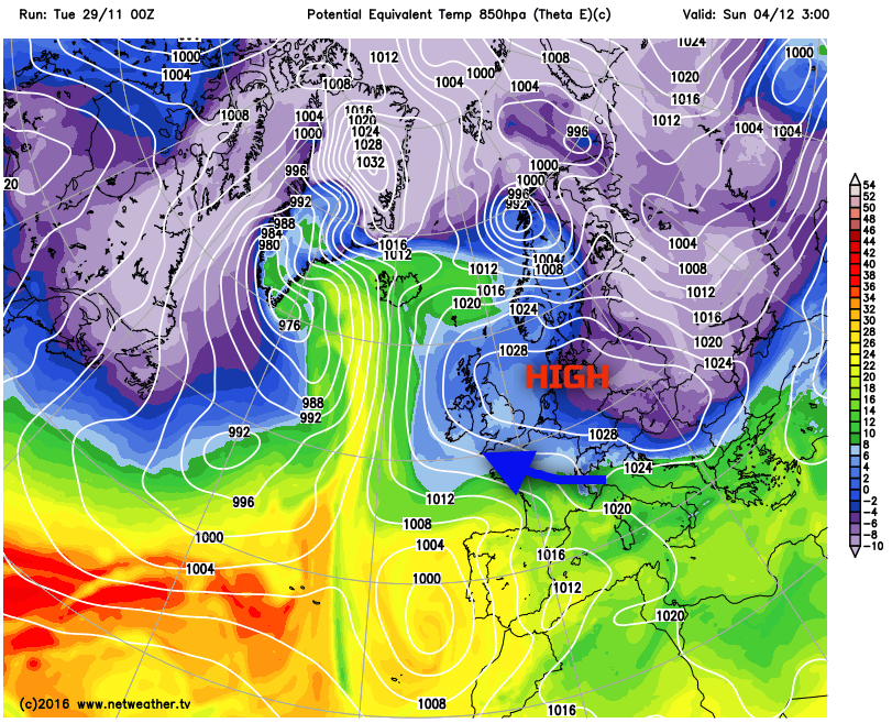
This is shown on the latest GFS image, using theta-e, for the end of Saturday and through into Sunday, the blue shadings over the UK again highlighting a relatively cold air mass and note the general feed into the UK is from the SE, from the Continent.
What this introduction of more of a SE’ly flow is likely to do is allow the lower layers of the atmosphere, the boundary layer, to dry out and, as a result, there is liable to be a greater propensity for any Sc or Cu to break up. At this range it is very difficult to say which areas of the UK will see most of the cloud breaks, but overall it is likely that it’ll be across England and Wales, where more in the way of sunshine will develop as the weekend progresses but this will also equate to a greater risk of frosts again by night as well.
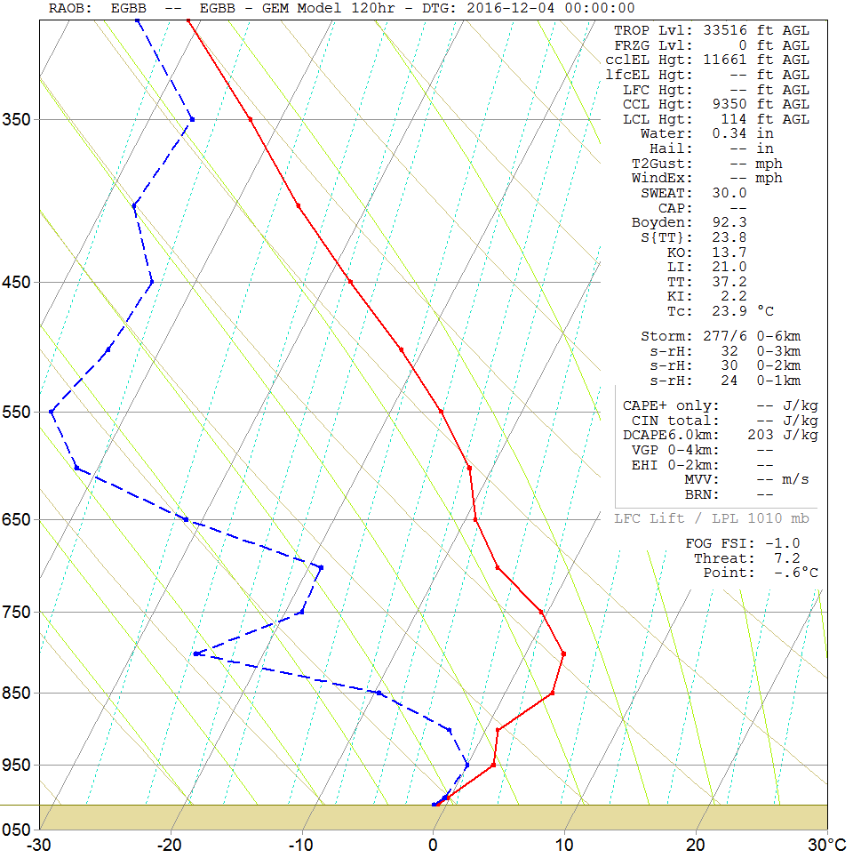
The forecast sounding for Birmingham on Saturday night and through into Sunday 4th highlights this expected change, with a large section of the low and mid atmosphere becoming increasingly dry again, large dew point depression in evidence and the large separation between the red (environmental temperature) and the blue dashed line (the dew point). There is some moisture within the boundary layer, but this is directly associated with a low-level inversion which could well highlight a risk of FG or FZFG too potentially. Also note that the surface temperatures and dew point are predicted to be sub-zero by 00Z on the 4th, the time of the forecast sounding which highlights that renewed risk of frosts this weekend.
The blocked regime, in-keeping the autumn as a whole, will continue throughout the next 5 to 7 days as the season comes to a close. Expect some recovery in temperature within the short term, along with a lower risk of frost around the middle of this coming week. However, towards the end of the week, through the weekend and into early next week the colder weather is likely to return but with a greater risk of cloud breaks developing and with them a renewed likelihood of frosts returning as well, as the benign, anticyclonic and blocked regime dominates.


