
SW and NW England saw flooding and disruption to start the week. Now it's turn for NW Italy and far SE of France for a risk of flooding
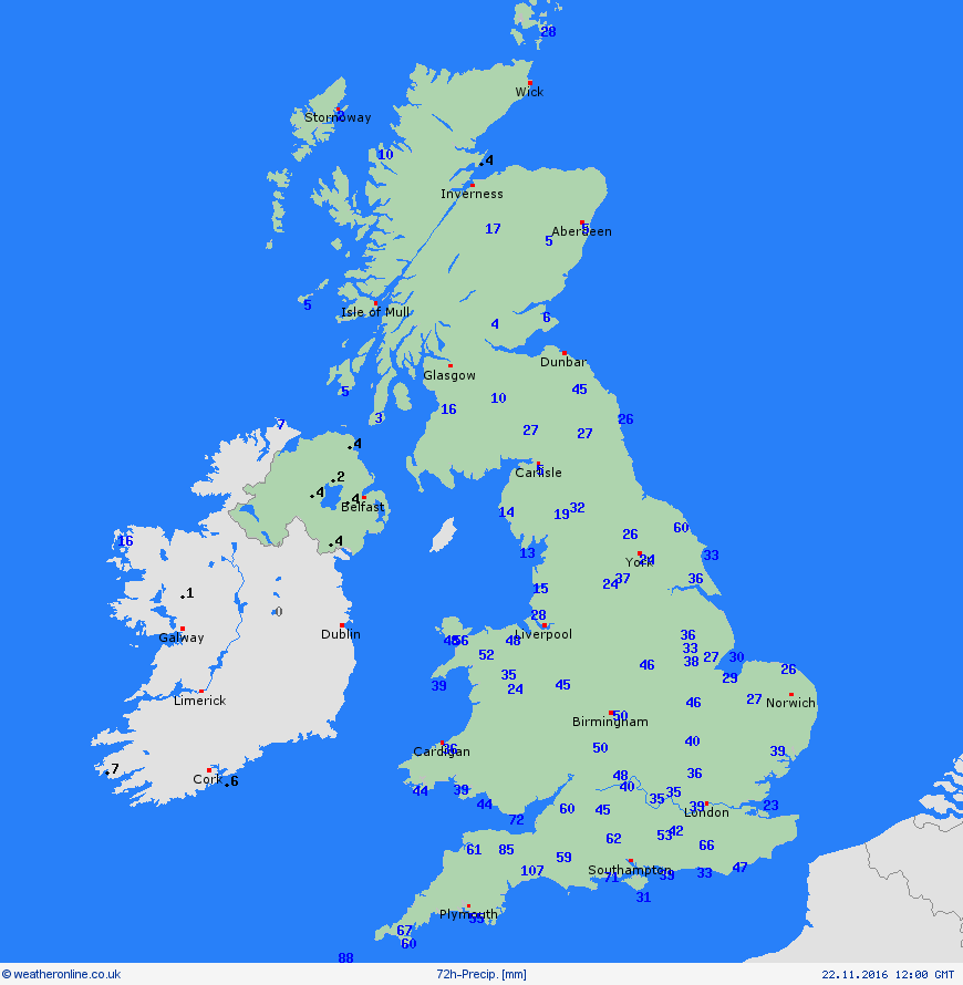
The week started with flooding across parts of SW England, thanks to heavy rainfall brought by Storm Angus at the weekend followed in close succession by another rain-laden low on Monday, which also brought severe gales across northern England and down the Irish Sea. Nearly a month’s worth of rain fell within hours across SW England. In the 48hrs up to 3pm on Monday, a whopping 96mm fell at Exeter Airport. Dunkeswell Airport, not far away, picked up 107mm in 78hrs. The November average for Devon is 136mm. Because Monday’s low moved at a snail’s pace across the southwest and hot on the heels of Storm Angus, the rivers couldn’t cope with the volume of rainfall over the two days, so there were 45 Flood Warnings across SW England in force on Monday evening. NW England was also hit by flooding on Monday, with Tameside and Oldham in Greater Manchester particularly badly hit following 3 inches of rain falling across the area.
72 hour rainfall totals ending noon Tuesday 22nd November
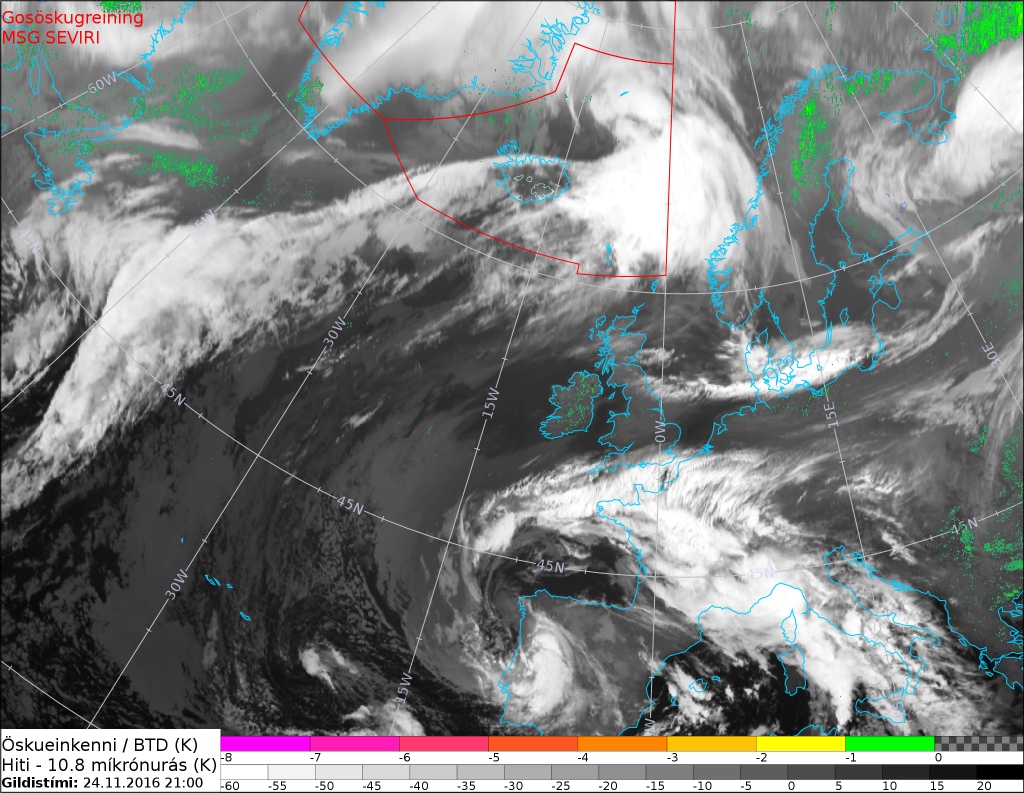
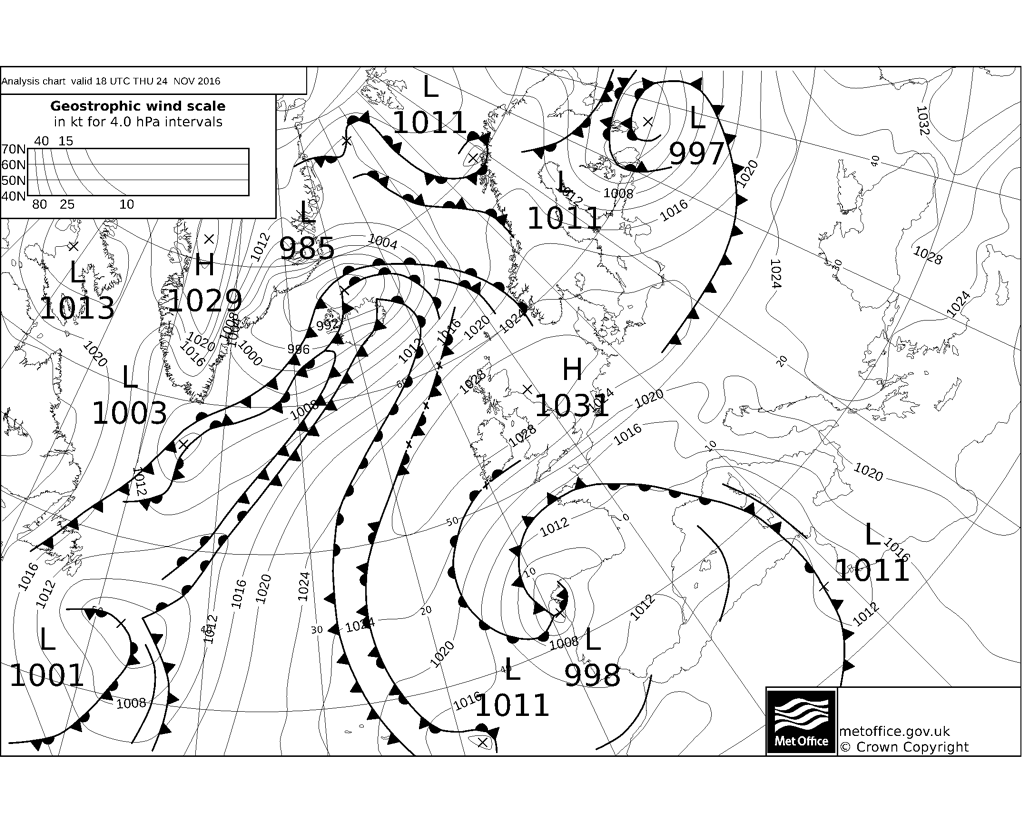
The second troublesome low that triggered the flooding on Monday drifted away northeast across the North Sea by Tuesday evening and was over Norway by early Wednesday. High pressure built in from the west across northern Britain since then and the anticyclone has been parked and centred over Scotland – bringing calm, sunny and cold conditions to northern Britain, with some harsh overnight frosts and some low daytime temperatures too.
So where has all the rain gone? There has been a slow-moving storm system that’s been swirling around across Spain and southern France since Tuesday and has been bringing heavy rain, storms and strong winds to this part of Europe. The system pushing north and northeast since yesterday afternoon has squeezed the isobars between it and high pressure over northern UK too, bringing gusts of 45-50mph across the far SE of England this afternoon.
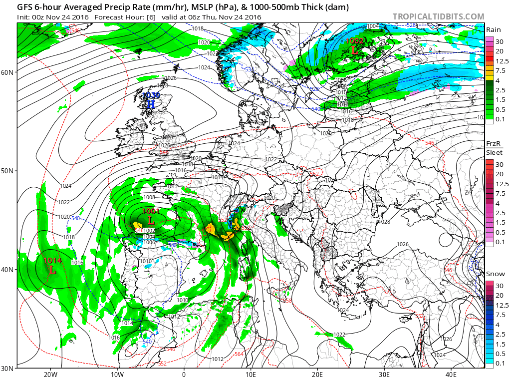
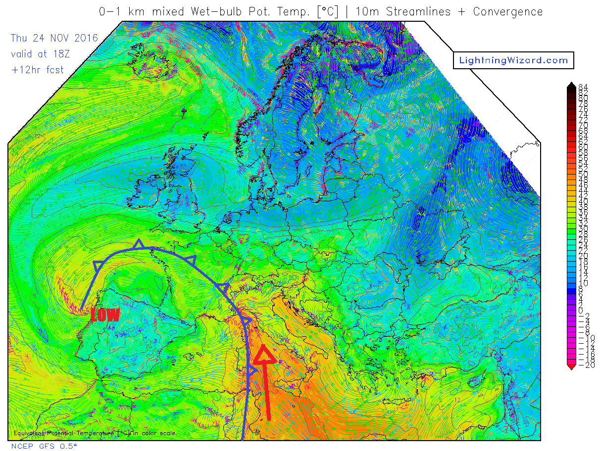
This large storm system covering SW Europe and the western Mediterranean will bring heavy rain and thunderstorms and strong winds further NE to SE France, Corsica, Sardinia and NW Italy today and into Friday. A cold front, which brought intense heavy rain, lightning and violent winds to southern France last night, continues to slowly arc N and E across central and SE France, Corsica and Sardinia Thursday afternoon before continuing N and E in across northern and western Italy over the next 24 hours. Waves developing along this cold front over the Med, which has deep warm and moist air advecting north off the warm Mediterranean ahead of it, will enhance the rainfall further as the front arrives across the Ligurian Sea and NW Italy. Combine this synoptic lift along the front with orographic lift of the Maritime Alps that create a natural border to France and Italy, the Ligurian mountains along the Gulf of Genoa and the Apennines running SE into Tuscany – then there is a recipe to lift copious amounts of moisture to its condensation level and produce large rainfall totals over the next 24 hours.
Cold front slowly drifting N and E across Corsica, Sardinia, NW and central Itally tonight, bringing extreme rainfall to upslope areas
Areas along the southern and southeastern slopes of the mountains in the Cote D’Azur of SE France and mountains of northwestern Italy could get 24-hour rainfall totals ranging from 100-200 mm (4-8 inches) generally Thursday into Friday morning. The EURO4 model shows totals between 250-300mm across parts of the Italian Alps. Heavy rainfall is not uncommon in this part of the world during autumn, as increasingly cold air aloft from the west moves over the NW Mediterranean where Sea Surface Temperatures (SSTs) are currently in the mid to high teens to low 20s in the southern Med – creating large instability and thus heavy rainfall. The Italian weather agencies have issued a red alert for flooding for Liguria and Piedmont regions.
Euro4 model showing 36hr rainfall totals of 200-300mm in places across NW Italy (image courtesy of Weatheronline)
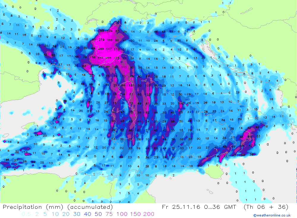
The large 24hr rainfall totals forecast by models across NW Italy, Corsica and far SE of France will likely lead to rivers overflowing their banks and also a risk of mudslides. Also the system will likely bury the Italian Alps with several metres of fresh snow. Some weather agencies are suggesting up to 500mm could fall in next 36 hrs:
Already today, torrential rain across Piedmont in NW Italy has led to the rivers to burst their banks. Also, Corsica (French Island in NW med) has seen intense rainfall today along almost stationary line along a slow-moving cold front, bringing a significant and rapid rise of rivers causing damage. 106 mm of rain fell in three hours at Rusio and 168 mm in six hours near Cambia. Roads have flooded or have become blocked by fallen trees, bridges swept away and also there’s been some landslides. Meteo France have issued a red alert for rain and flooding across northern Corsica, with several departments in SE France under an orange alert. These areas on the mainland have already experienced wind damage and heavy rain last night, as intense squall line moved from the SW along the cold front.
The heavy band of rain will shift slowly east across the leg of Italy on Friday, before drier conditions return across NW Italy and SE France on Saturday, with the heavy rains affecting the Adriatic and lands bordering it to the east.


