


High pressure developing from midweek will bring more benign conditions across the UK.
Issued at 1500GMT on Tuesday 22nd Nov based on 22nd Nov 00Z Model Runs
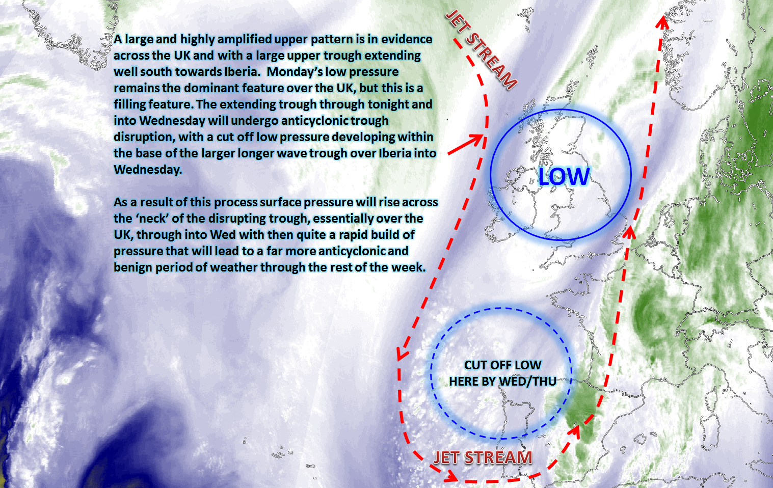
Rest of Tue: Forecast model agreement is good through the rest of Tuesday, but there are some HRES model differences over where most of the precipitation will be through the remainder of the day. Monday’s low pressure is still in evidence across most of England and Wales in particular, with sporadic regions of rain and showers, but with some forcing still in evidence associated with a frontal zone over parts of S Scotland and N England. A lot of low cloud remains across England and Wales, but this is in contrast with most of Scotland and especially Ireland which will continue to be to the north and west of the main surface low pressure and more importantly away from the low’s fronts. The low pressure is a filling feature mind and will pull away to the north-east this evening and overnight. High confidence for a distinct north and west, south and east split in conditions this evening and overnight with Scotland, the far north of England and all of Ireland experiencing increasingly anticyclonic conditions with a lot of clear skies and, as a result, a cold night with frost expected here. A lot of cloud will remain across England and Wales with some further light rain or drizzle, and it will be a milder here than compared with further north and west. The important development this evening and overnight though is that of anticyclonic trough disruption, with the broader upper trough over the UK at the moment disrupting with a cut-off low pressure developing within the base of the trough across Iberia into mid-week. Within the neck of the disrupting trough, across the UK, will be a build of pressure and this then sets the scene for another blocked regime across the UK in the days ahead. This is shown perfectly by the GFS MSLP and jet-stream; clearly noting how the broader upper trough disrupts and the UK suddenly goes from a distinctly cyclonic pattern to one being anticyclonic within 24 hours or so.
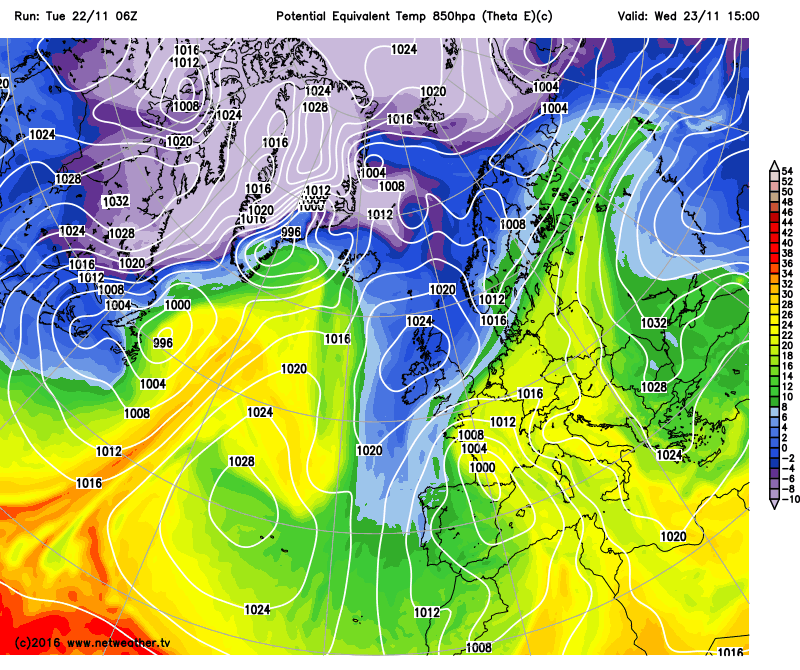
Wed 23rd: As we move into Wednesday and model agreement continues to be good with the GEM, GFS, ARPEGE, EC, UKMO and JMA all showing the disrupting trough becoming a closed upper level low with a surface low pressure across Iberia in particular, but also across France. Across the UK and pressure then steadily rises through the day with the GEM, GFS, ARPEGE, ECM, UKMO and JMA all signalling a surface high pressure to be situated essentially across Scotland later in the day with a central pressure of around 1030mb. An E or NE’ly flow develops across the southern flank of the high pressure across S England with still some weak frontal activity embedded within this flow. As for the day itself, it will be a cold or locally very cold start across Scotland, Ireland and N England with a widespread frost, along with mist, fog and freezing fog patches too. Less cold for most of England and Wales and most of central and southern areas of England and Wales will then remain mostly cloudy as the day progresses with some light rain or showers, again directly associated with some residual frontal activity in conjunction with the trough disruption process. However, for many areas of Scotland, Ireland and N England, after the cold start, it will be a cold and crisp November’s day with plenty of sunshine expected. The high pressure developing into the UK will have beneath it relatively cold air. It is a good example of how 850mb temperatures may well be above the inversion level beneath the high pressure and won’t really give an indication of how cold the air mass is. However, a better tool in this situation is theta-e (equivalent potential temperature) at the 850mb temperature, and the GFS highlights perfectly that the air mass beneath the high pressure is indeed quite cold (blue shading), especially within the boundary layer. Fog or freezing fog patches may well linger too more locally and where these do then temperatures will struggle to get much above 0C or 1C.
Thu 24th and Fri 25th: As we progress through the end of the week and, for many, the anticyclonic conditions will continue. In comparison to earlier in the week, the weather will be far more benign and far more settled given this build of pressure across many areas. The GEM, GFS, UKMO and ECM are all in reasonable agreement for pressure to rise to around 1030mb into Thursday before then falling a little to around 1027mb into Friday. However, what is important is the orientation of the main surface high pressure. Through the end of the week, all the models mentioned above have the high pressure orientated west to east across the UK in a more oval kind-of-shape. This means that frontal systems will be passing over the top of the high pressure, in association with the jet stream tracking to the north of the UK, whilst the cut-off surface low pressure over Iberia and parts of France may well influence the far south of the UK. As a result extreme northern and southern areas of the UK may well gradually become cloudier through the end of the week with perhaps some light precipitation at times. Importantly more of a SW’ly breeze across the far north of the UK and an E or NE’ly breeze across the far south will mean somewhat milder conditions are likely here, especially by night. It will be through more central areas of the UK the best of the sunshine will be to end the week and also where most of the mist, fog and frost will be at night.
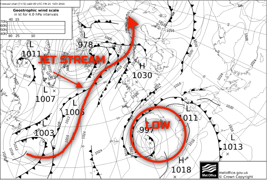
The 00Z UKMO FAX for 00Z Fri 25th highlights this well, noting that around the periphery of the high there are some weak frontal systems. The main issue, as is often the case in this setup, is boundary layer details with certainly some uncertainties over how much light precipitation will affect far southern and northern areas of the UK and which central areas will experience best of the sunshine. At this time of year whilst clear skies can lead to plenty of sunshine by day, the importance is clearing skies at night will bring widespread frosts and these are still most likely across central and southern areas of Scotland, down across Ireland, N England, into parts of Wales and the Midlands.
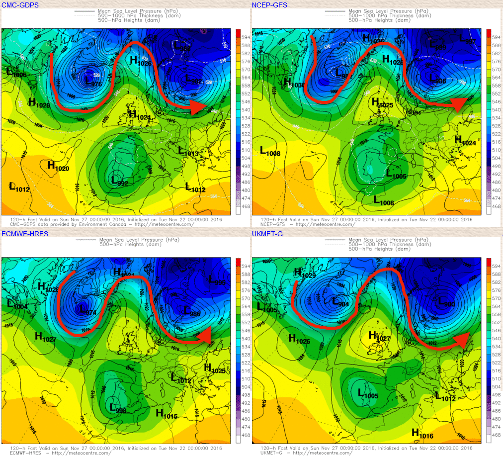
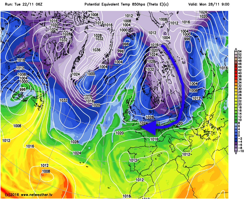
Sat 26th and Sun 27th: As we move into next weekend and there is high confidence that anticyclonic conditions will continue. There are some differences in the orientation of the high pressure as the weekend progresses, with the UKMO, GEM, GFS and the ECM all indicating this change through Sunday, with it extending northwards as trough extension takes place to the east of the UK. However, Saturday looks likely to produce very similar conditions to the end of the week with much of the UK fine and settled, but still with some light precipitation around the periphery of the high pressure, across more northern and southern areas. By this point forecast soundings do show more cloud inland, but even then there is still likely to be some cloud breaks and confidence in cloud amounts and resultant max and min temperatures by Saturday is low. Further overnight mist, fog and frost are likely, especially locally. The change in location of the high pressure through Sunday and into early next week may then allow for colder air to filter down the eastern flank of the high pressure, as CAA takes place out of Scandinavia and down into central areas of Europe. This change in position of the high pressure, mainly due to WAA on its western flank which aids in allowing the surface high to build northwards, is highlighted well on the below main GM’s, with the approximate location of the jet stream overlaid. Importantly note that yet another meridional pattern develops something which has been a feature of the autumn period.
The potential introduction of colder air down the eastern flank of the high pressure looks likely, but it is the overall location and orientation of the high pressure that will then determine whether more of an E or NE’ly flow can be achieved and with then some colder air being advected into the UK. Any incursion of lower WBPT will likely aid to break up any boundary layer cloud and lead to a greater risk of more widespread frosts later in the weekend and into the start of next week. The 00Z runs are quite divided as to whether that is a possibility or not, but the 06Z GFS DET does highlight this potential at least, as shown in the below image.
After the particularly unsettled period of weather over the last few days, it is all change again as we see a return to more blocked conditions through the rest of the week, into the coming weekend and most likely into early next week too. It would seem that the far north and south of the UK will, overall, be cloudier and milder than more central areas of the UK given the orientation of the high pressure, with the coldest conditions likely anywhere from the Midlands northwards through into central and southern parts of Scotland, across into Ireland too. Boundary layer issues develop with time, with uncertainties over cloud amounts both by day and by night and how this will influence Tmax and Tmin, and we then look to the potential development of a colder low-level flow from the E or NE early next week depending on what happens with the orientation of the high pressure. Temperatures look set to be near or perhaps slightly below average overall and with a clear bias towards drier than average conditions through the remainder of November now after what has been quite a wet month though for most.


