A lot happening synoptically this week with colder air moving across the UK, and the risk of some stormy weather this weekend.
Issued at 1500GMT on Tuesday 15th Nov based on 15th Nov 00Z Model Runs
Rest of Tuesday
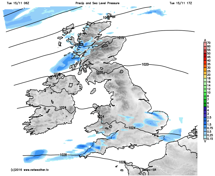
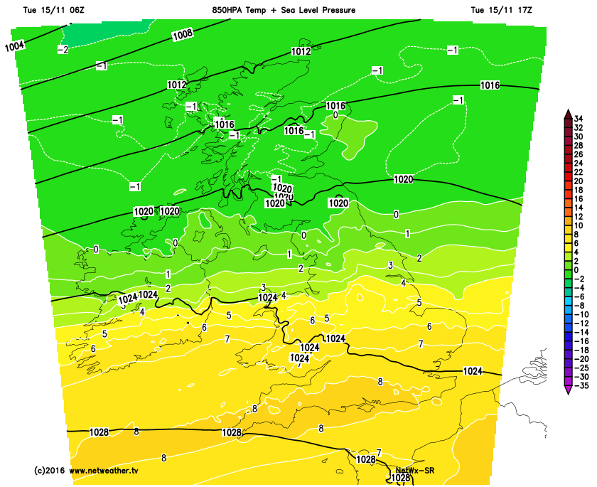
Forecast model agreement is good through the remainder of Tuesday with, essentially the first stage of a progression towards cooler and then colder conditions underway. A weak cold front moving southwards across more central and southern areas of England and Wales is clearing away the tropical maritime air mass of Sunday and into Monday which brought some extensive low cloud, hill fog and drizzle for many northern and western areas. Through the remainder of Tuesday and most of Scotland, Ireland and N England are into the cooler air mass, not cold by any means yet, but it is cooler but with some sunshine too and just scattered convective development across Scotland. The weak cold front will continue to move southwards across central and southern areas through the rest of the day, HRES model agreement is good regarding the evolution, with further sporadic regions of light rain and drizzle to be expected. It remains misty and murky too in association with the cold front and it will be quite a ‘painful’ process with the cold front not clearing the south coast until well into the early hours of Wednesday. The cold front is evident on the SR HRES model across the south this evening and is essentially the boundary between >+7C 850mb temps in the south and 850mb temps nearing or falling sub-zero further north
Wed 16th
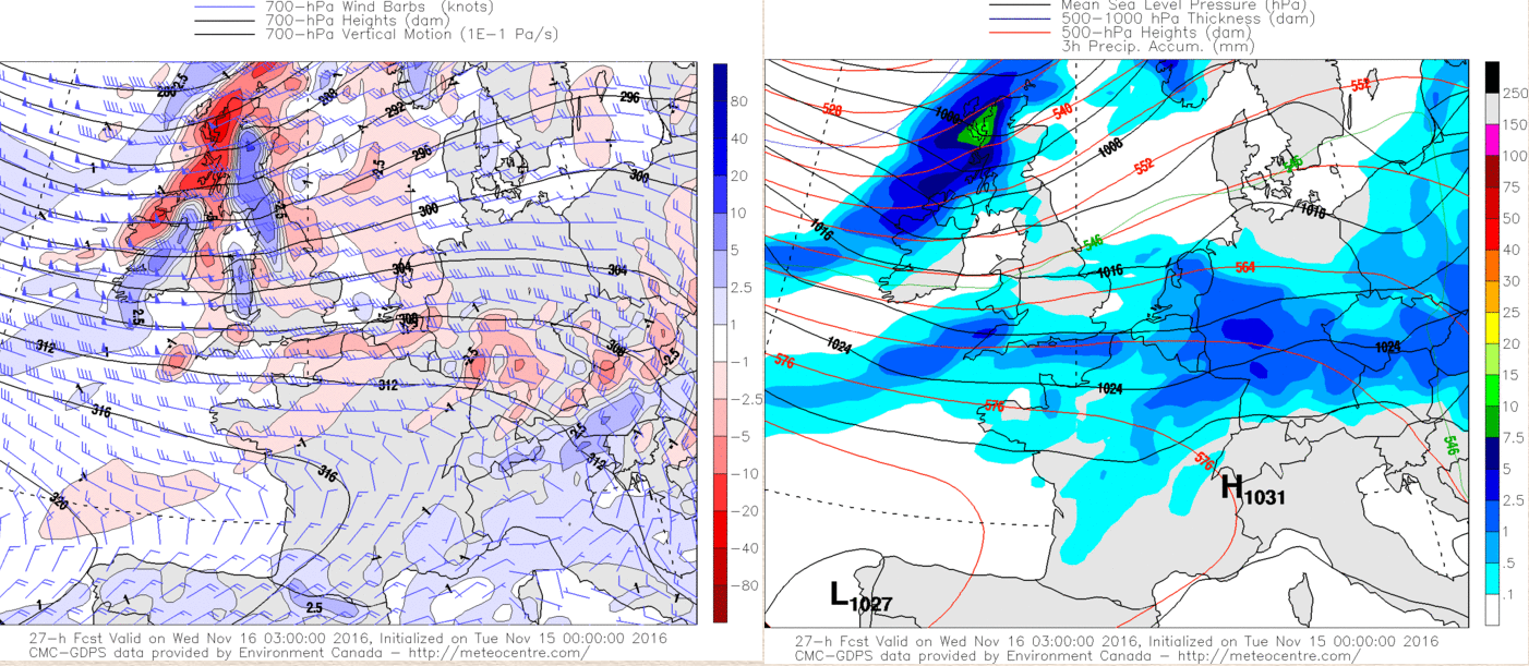
As we move into Wednesday and model agreement continues to be good with the GEM, GFS, ARPEGE, EC, UKMO and JMA all signalling an area of low pressure over Iceland with a central pressure around 969mb. This area of low pressure, associated with a broad upper trough, dominates the weather across the NE Atlantic and a dynamically active cold front will move into Scotland and Ireland through the early hours of Wednesday and then steadily progress southwards across the rest of England and Wales through the day. This is, essentially, stage 2 towards colder weather and it is behind this cold front that a more marked polar maritime air mass exists. The front, initially at least, be well forced with marked PVA interacting with the cold front to bring some squally conditions through the early hours of Wednesday across Scotland and Ireland. Some embedded instability is possible too with both dynamic and convective rainfall likely, perhaps with some hail and thunder too.
However, model agreement continues to be good for this front to essentially lose connection with any forcing as it moves down into N England and N Wales on Wednesday morning and precipitation quickly becomes light and more fragmented and will move across central and southern areas of England as a very weak feature indeed. Despite this, it will still be associated with a marked thermal boundary and, again, it is behind this cold front that a more substantial polar maritime air mass will then develop across the UK. Sea temperatures around the UK generally remain above average and as the upper temperatures cool from the NW through Wednesday then convective development, sea surface based, will develop across Scotland and Ireland initially before spreading further south into N England. At the same time the cold front will bring some patchy rain or showers to S England, but otherwise, the afternoon will be mainly dry here with some brighter intervals at times. The GEM model highlights the dynamically active front well, noting the pronounced region of vertical motion into many northern and western areas into early Wednesday.
Thu 17th and Fri 18th
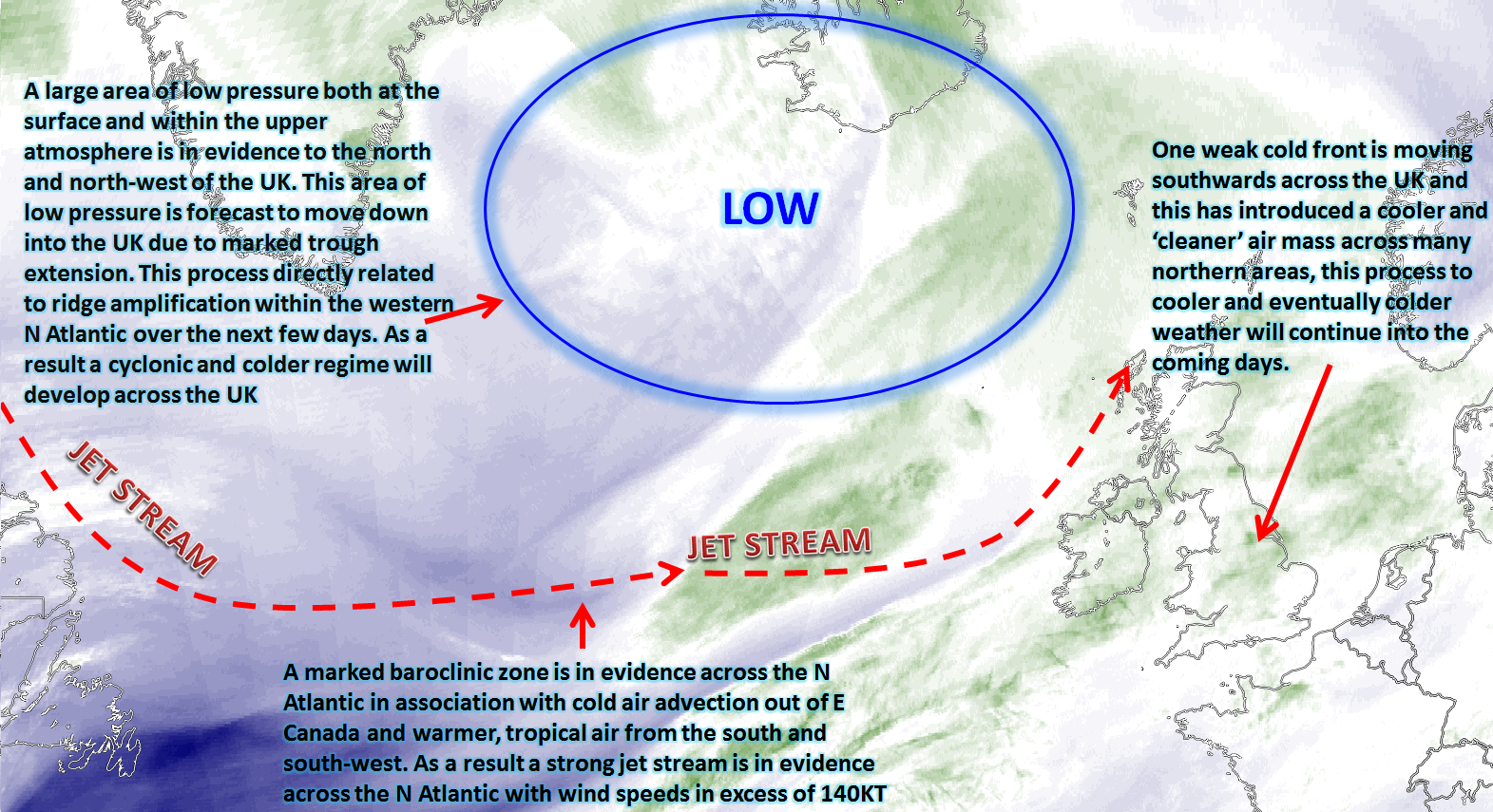
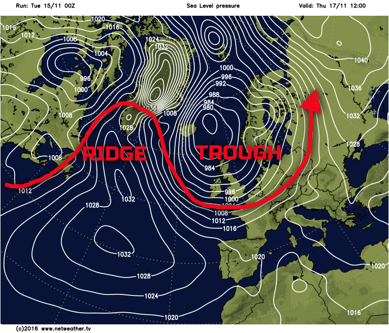
As we move into Thursday and again model agreement remains good with the development of the broader patterns across the N Atlantic. By the time we get to Thursday there will have been a marked amplification of the pattern across the N Atlantic. This aided by WAA across the eastern seaboard of the USA and also into E Canada, which, in-turn, allows for the surface and upper-level-low to move down into the UK creating a cold and cyclonic pattern across the UK. This broader evolution can be seen first on the GFS chart below.
At the surface, across the UK, the weather will be dominated by surface based convection, this directly orchestrated because a cold air mass will be moving over a relatively warm sea surface around the UK and across NW Europe in general. As a result, Thursday will produce a mixture of sunshine and blustery showers across many areas of the country. The showers, whilst primarily around coastal areas, will be driven well in-land in association with a fresh or strong W or SW’ly wind, this veering more NW’ly later in the day. There is some signal within the forecast models, but also evident on the overnight UKMO FAX for Thursday for perhaps a frontal wave to quickly move through the flow across more southern areas of England. If this does arrive then, it may well mean a more prolonged spell of rain for southern areas of England and Wales during the day. Overall, though, it is a highly convective day with the showers often heavy with hail and thunder certainly possible.
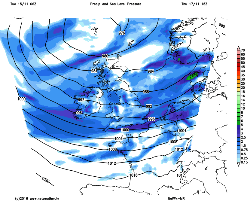
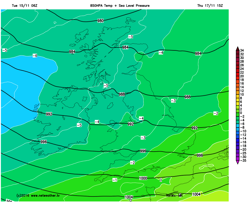
The air mass will continue to cool and with the -5C 850mb isotherm moving into more northern and western areas of the UK as the day progresses. At the moment wintry precipitation is possible above around 250m to 300m across Scotland, Ireland and N England but with any settling snowfall generally above 300m to 350m really, especially during the day. Hail, however, could well fall to low levels with certainly some of the showers bringing a potential threat of a covering of hail, leading to poor driving conditions, locally within a short space of time. The MR NetWx model highlights the broader pattern and note the continued cooling air mass from the west and north-west too.
We end the working week with essentially a surface low and upper vortex over the UK in conjunction with major trough extension and with the jet stream passing to the south and east of the UK. The overall, broader model guidance is for a similar period of weather to continue as is expected on Thursday, so another day of sunshine and blustery showers. These, again, often heavy with hail and thunder possible, along with sleet and snow across hills of the north, perhaps by this time there could well be some appreciable accumulations above around 350m or so across Scotland and perhaps the Pennines depending on shower frequency and distribution.
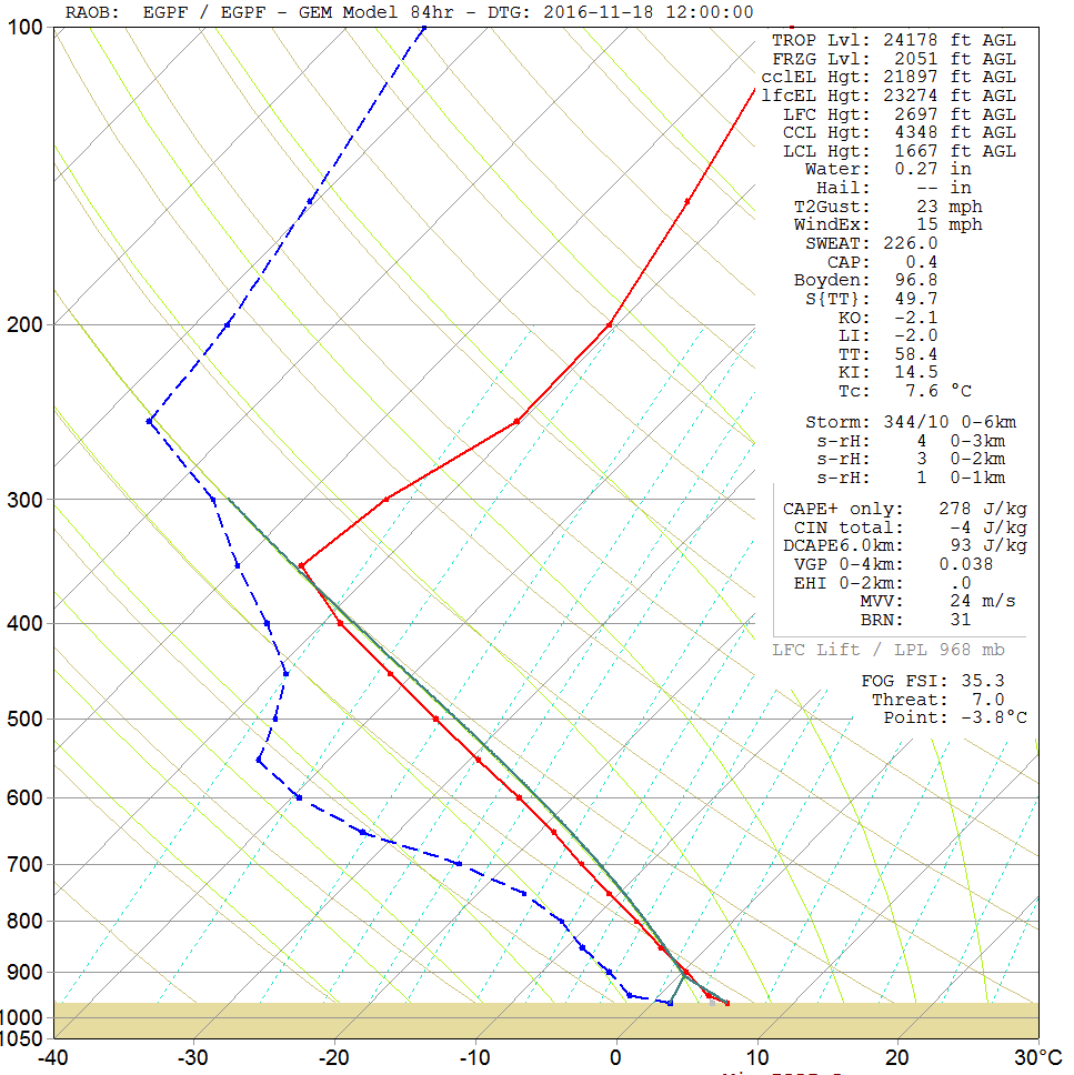
The air mass will be cold enough for overnight frosts and maybe some icy patches too during the end of the week, but the continued expected development of a fresh or strong W or NW’ly wind will, overall, prohibit any widespread development. Highlighting the broader air mass type over the UK is the forecast sounding for Glasgow on Friday afternoon, noting the very steep lapse rates with regards to both air temperature and dew point through the atmosphere and hence the convective threat. Note the freezing level of 2051ft to, this would rapidly fall to much lower levels during heavy showers.
Sat 19th and Sun 20th
As we move into next weekend and it is likely to be a cold and frosty start on Saturday with a fairly widespread frost by this point, along with icy patches too. The primary reason for this is that all the main GM’s all indicate a general reduction in the PGF and, hence, lower wind speeds compared with previous days.
The main feature of interest through next weekend is the potential development of an area of low pressure to the west of the UK to start with, and this then moving into the UK some shape or form as the weekend progresses. A possible cyclogenesis event to the west and north-west of the UK may well develop due to the on-going strong baroclinic zone (strong thermal gradient) to the west and north-west of the UK. The developing low looks set to ‘dumb-bell’ around the parent low that will have been in evidence over and to the north of the UK to end the week. Now the development of this surface low pressure is complex and recent runs have tracked this low pressure further south, crossing England and Wales later on Saturday and through into Sunday. This means that areas to the north and west of the low’s centre, so most of N England, Scotland and Ireland, remain within a cold air mass, but further south and east it generally becomes somewhat milder. There may well be a risk of snow on the northern edge of the low pressure too, again depending on subsequent developments, but one of the main issues and causes for concern could be some very strong winds across southern counties of England and through the English Channel in general.
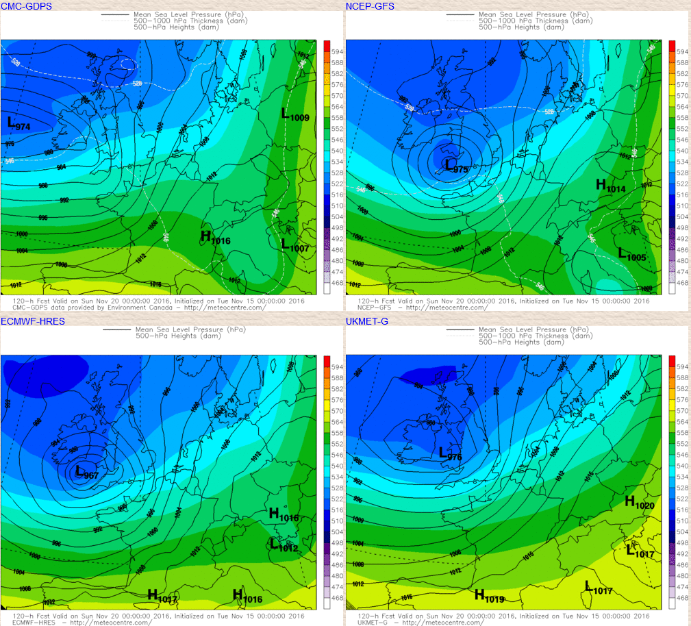
Highlighting this development, as things stand, are the GEM, GFS, ECM and the UKMO for 0000Z on Sun 20th. Note the different output from the GEM, but otherwise there is certainly some model consistency over a more S’ly track than compared with previous runs and clearly for this to be quite a deep low pressure with some very strong winds on its southern flank, the 00Z EC HRES in particular showing a low around 967mb. This system could well bring a variety of inclement and possible severe weather conditions from gales or severe gales for parts of the south, heavy rain for central and southern areas of England and perhaps with snow on the north flank over N England and perhaps S Scotland for example. Clearly, the details are unknown at this range, but there is certainly some likelihood that after a cold showery end to the week, attention will then be drawn to this area of low pressure moving into the UK. As ever, we’ll keep you posted on that in the coming days with our usual forecasts and blogs and this system may well become the first named storm of the season.
So, after some brief milder weather within the last day or so it is clearly all change as colder weather arrives and of which will continue to reinforce what is turning out to be quite a cold November, especially after the warmth of September and October. The cold and showery weather during Thursday and Friday will be a talking point, bringing some lively weather on a local scale due to heavy downpours, hail, thunder and sleet and snow, whilst a marked wind-chill factor will develop too. All eyes will then be on the developing low for next weekend and the potential array of weather conditions that it may well bring.