The latest synoptic guidance blog - a cold start to this week but eventually becoming milder.
Issued at 1500GMT on Tuesday 8th Nov based on 8th Nov 00Z Model Runs
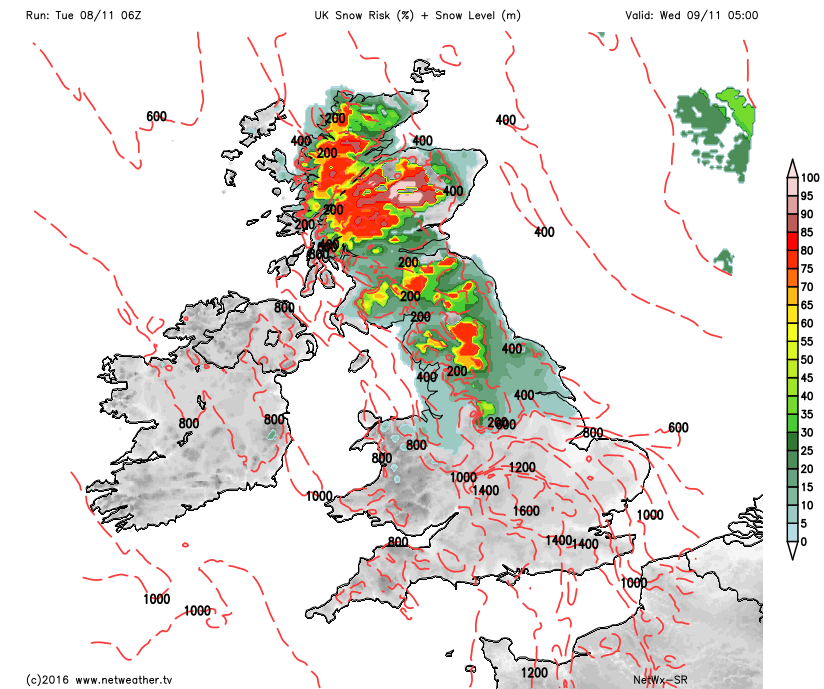
Rest of Tue: Forecast model agreement is good, primarily higher resolution shorter range models (ARPEGE, EURO4, etc.) with regards to the development of snow across higher ground of N England and Scotland through the rest of the day and overnight into Wednesday. This development comes about due to a blocking area of high pressure to the NE essentially stopping the natural west to east progression of a set of frontal zones and a complex evolution where shear vorticity will interact with frontal zones trying to move into the UK, to then create an individual surface low pressure over England and Wales tonight. The cold air mass that remains in place over the UK from the last few days will combine with the advancing frontal precipitation to bring the first widespread risk of snow, especially above 200m to 250m from the south Pennines northwards this evening and overnight. There is certainly scope for snow to lower levels, perhaps as far south as the Midlands into Wednesday morning but it is likely that higher ground of N England and Scotland will see several centimetres of snow over the next 12 hours or so. There is also some focus in HRES output for some large totals, over 10cm to 15cm of snow around parts of E Lancashire, W Yorkshire and down into parts of Derbyshire through into the early hours of Wednesday due to this region potentially seeing more in the way of moderate or even heavy snowfall at times. This is the primary focus of attention through the rest of the day and overnight, with other areas away from the north essentially having a cloudy and wet end to the day as frontal precipitation moves in. It should be noted too mind that some large rainfall totals are likely across some southern and western areas of England and parts of Wales too with over 25mm certainly possible tonight and into Wednesday. Focusing on the snow risk mind and our HRES model highlights the primary areas at risk in conjunction with predicted freezing levels of around 200m to 400m.
Wed 9th: As we move into Wednesday and model agreement continues to be good with the GEM, GFS, ARPEGE, EC, UKMO and JMA all signalling an area of low pressure over central and southern areas of England and Wales with a central pressure around 994mb. The complex evolution maintains a real mix of precipitation types across the UK with many central and southern areas of England and Wales having rain or showers through Wednesday morning, but with residual sleet and snow still likely across some parts of the Midlands and N England in particular. It is across these areas that some particularly poor travelling conditions are possible first thing. As Wednesday progresses model, guidance indicates the surface low pressure will slowly move down into parts of N France, but lingering close to SE England to maintain a risk of both convective and dynamic frontal precipitation here well into the afternoon. Elsewhere a chilly W or NW’ly regime becomes established behind the low pressure and this, as a result, brings a convective mix of sunshine and showers to many northern and western areas of the UK. The air mass, however, will have been modified compared with the last few days and clearly with more of a polar maritime aspect to the air mass then wintry precipitation as Wednesday progress will be restricted to ground above 300m or so across more northern areas of the UK.
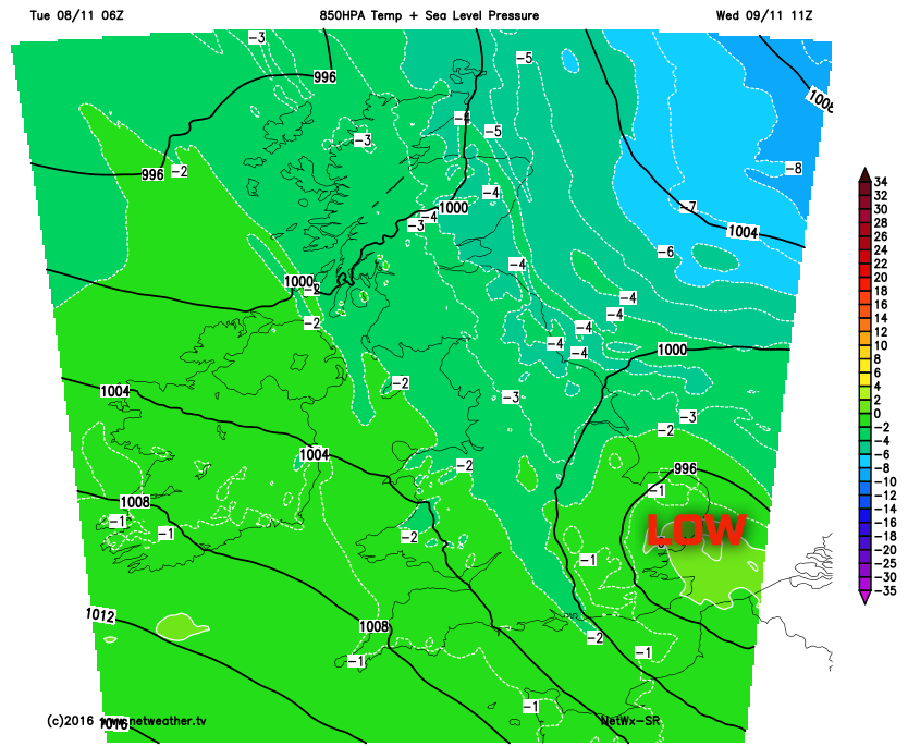
It will, however, be another cold day for many due to a lot of cloud and a lack of insolation, with the exception of S England where it will be somewhat milder, for anywhere from the Midlands northwards will maintain low single figure Tmax temperatures once again. Our HRES model highlights the surface low pressure and note how sub -5C 850mb temperatures are held to the E and NE of the UK with values higher than the last few days across most areas at around -1C to -4C, but this still highlighting quite a chilly air mass for most.
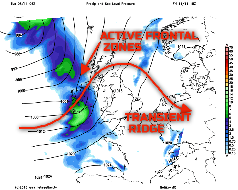
Thu 10th and Fri 11th: As we approach the latter half of the week and trough extension within the W Atlantic, in association with surface cyclonic development, allows for some minor ridge amplification downstream, to the west of the UK. As a result, as we move into Thursday and there will be more of an anticyclonic influence to the upper pattern. This doesn’t mean a completely dry day is expected as low pressure will be close-by to the east and north-east of the UK. However, what it does signal is a ‘window’ of generally drier and more benign weather conditions through the day with the exception of some showery weather at times, especially around coastal areas of the UK. The emphasis for many inland areas though will be on a lot of fine and dry weather with some sunshine, but it will remain quite cold. A minor and transient ridge is then expected to progress across the UK overnight on Thursday and into Friday, this is highlighted well on all main GM’s (UKMO, GFS, ECMWF and GEM for example) and is likely to allow for another cold night on Thursday night into Friday with a risk of frost and perhaps some mist and fog patches too. As we move into Friday and any transient and minor ridge declines away and arriving from the west will be a more active set of frontal zones, these are likely to be well forced and, as a result, contain some moderate or locally heavy rain. There will also be a more pronounced warm sector in association with the fronts too as such that temperatures will finally rise across most areas as Friday progresses after a cold start. A case of the further east you are on Friday then the better the weather will be for longer, as wet, windy and milder conditions then spread eastwards throughout the day.
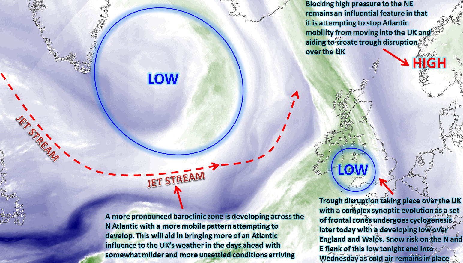
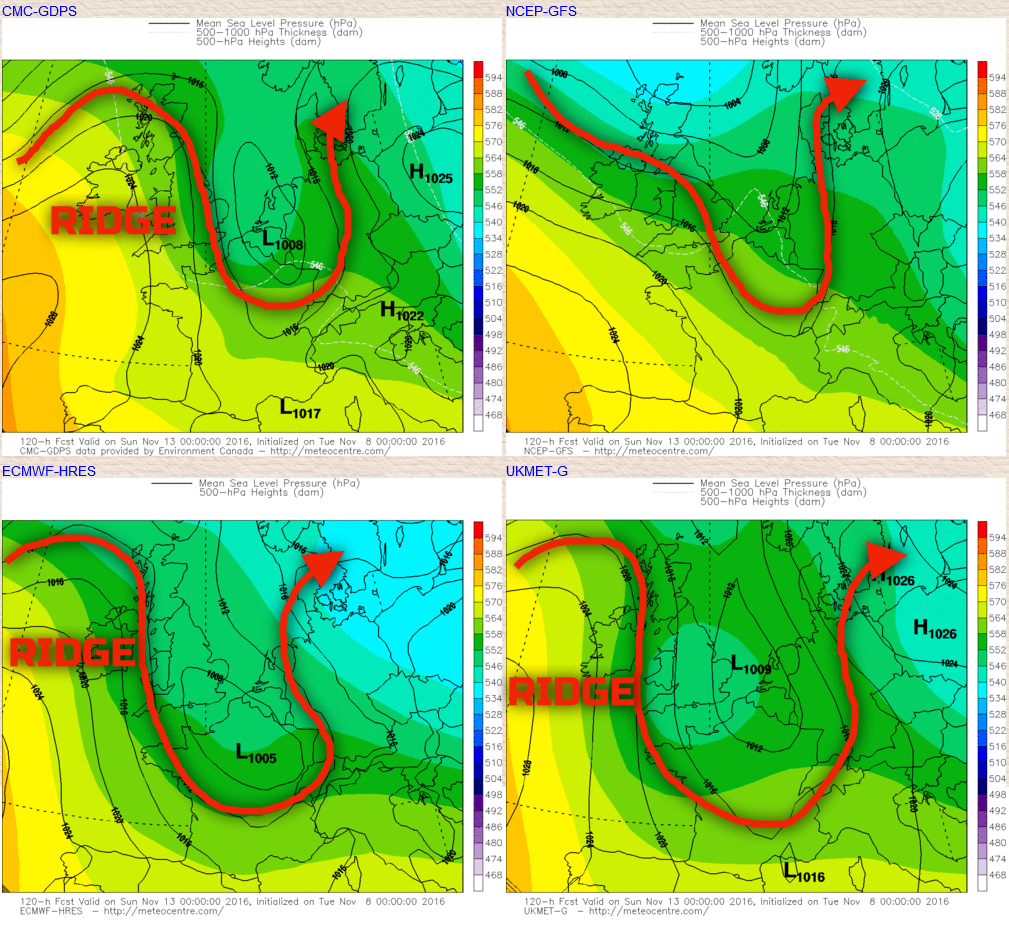
Sat 12th and Sun 13th: As we move into next weekend there are definitely signs within the main GM’s for trough disruption to take place across the UK which, at this range, means quite a lot of uncertainty over the details at least. The frontal systems from Friday are likely to be in place over the UK as we move into Saturday so a likely wet and unsettled start to the weekend, potentially quite windy as well too given latest guidance. However, this progression towards anticyclonic trough disruption is certainly present within the main GM’s in that a surface low pressure develops either over S England and France as we move into Sunday and within the ‘neck’ of the disrupting trough then pressure is allowed rise from the west and south-west. This is exampled well on the below charts with the red arrow highlighting the general position of the jet stream and the trough, but note especially on the GEM, ECMWF and the UKMO that a closed surface low pressure develops, but then quickly following, due to trough disruption, is a potential rise in GPH from the west. The 00Z GFS was less interested in this development and given the complexities of trough disruption then there are clearly a lot of uncertainties over the details. However, as things stand an unsettled day for most of the UK on Saturday with rain, showers and strong winds clearing to then allow for a rise in pressure as Sunday progresses with generally better weather developing and perhaps with a dip in temperatures again too after milder weather of Friday and Saturday.
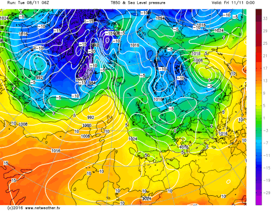
The progression towards more in the way of milder conditions later in the week is exampled well on the below animation. It does look like it’ll take until Friday and Saturday for a more marked rise in 850mb temperatures. So until then it will remain quite chilly, but by the time we end the week and move into the weekend temperatures will, overall, be higher for many than compared with of late, especially so by night with the risk of frost easing too.