
Blocking high pressure looks to continue to dominate the UK weather through to the end of October and perhaps into early November.
For October’s weather in the UK to be fairly quiet, settled and dry in the UK for much of the month is fairly uncommon. Usually the Atlantic begins to stir into action during the month as high latitudes grow colder with the longer nights and create a strong thermal gradient which strengths the jet stream to bring deep lows and the more usual wet and windy spells of weather to the UK at this time of year.
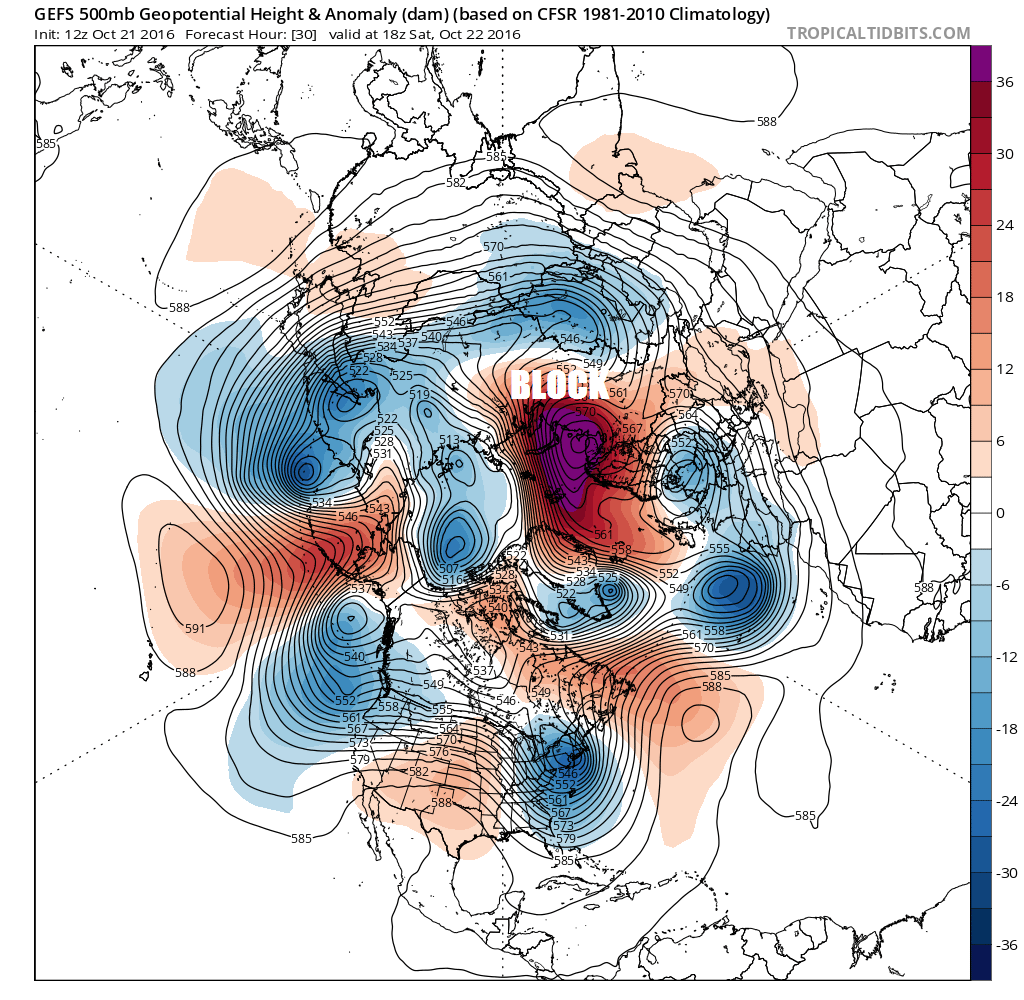
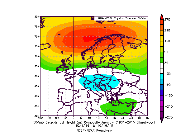
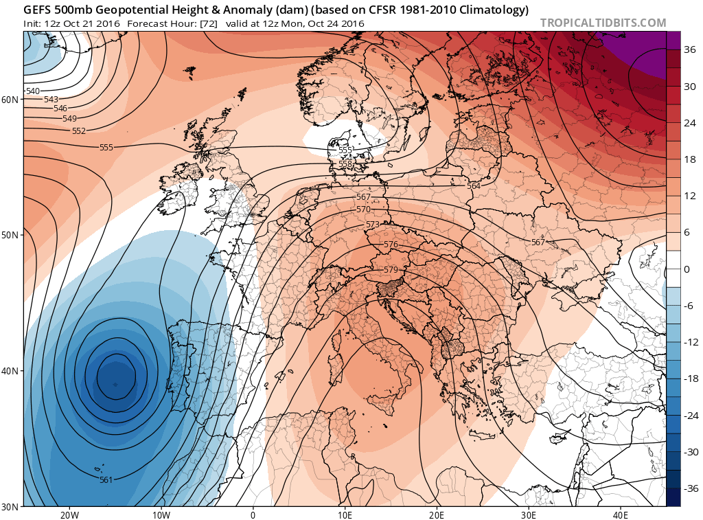
The upper flow pattern over the Atlantic and Europe has been rather blocked or stuck in a rut over the last 3 weeks, with many parts of the UK seeing only 20% of the October average rainfall. And the same looks likely during the last week of October. A blocking area of high pressure centred over Scandinavia and NW Russia for much of the month so far. The block to the northeast weakened and receded a little last weekend, allowing low pressure in. But the block strengthened again this week, with a little help of warm air being pulled north up into mid-levels of the atmosphere at high latitudes by a deep low track towards Greenland containing the remnants of Hurricane Nicole.
Blocking high has dominated Scandinavia for much of the month so far
It does look like the high pressure block over Scandinavia will retreat eastwards/southeastwards into western Russia next week, looking at current weather model operational runs and their ensemble guidance. This allows low pressure the southwest to muscle in across southern areas to bring some brief wet and windy weather early next week.
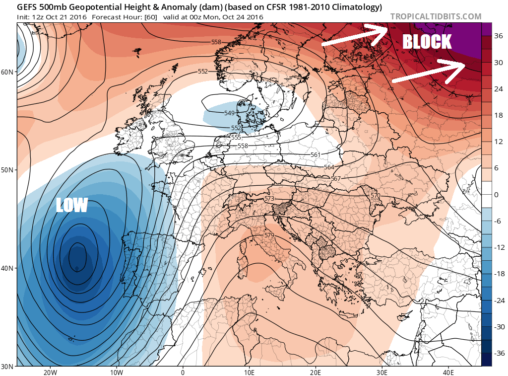
But with the upper flow amplified into a meridional/wavy pattern by recent blocking, the low to the SW retreats south towards the Canary Isles and then a new ridge builds across the southern areas by mid-next week, turning into a blocking high that will dominate much of western Europe, keeping Atlantic depressions well at bay over NW Atlantic, southern Greenland and Iceland.
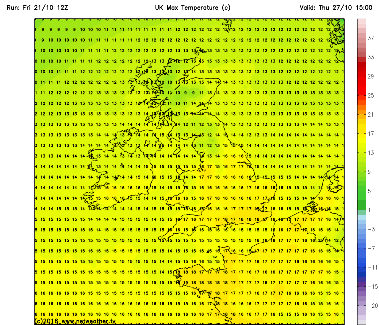
The ridge looks persist into the last few days of October, perhaps positioning itself to draw quite warm air north by the last weekend of the month, with temperatures indicated reaching high teens in the south as early as next Thursday. Which is well above average for the end of October.
Looking further ahead into early November, ensemble guidance indicates that blocking maybe present to start the month across much of western Europe and also indicates the potential for ‘retrogression’ of this block further NW across the North Atlantic to the west of the British Isles with troughing across Scandinavia. This would indicate the potential for northerly or northwesterly outbreaks early on in the month. So potential for some colder polar or arctic flows that may bring some wintriness to the north and a risk of widespread frosts. A long way off the first week of November in weather forecasting terms, so although there is a good chance that blocking will still be dominating our weather, not great confidence this far off in where the blocking areas of high pressure will position themselves.
So what’s causing all this blocking at the moment? One reason could be the recently active hurricane season over the North Atlantic and also active Typhoon season over the North Pacific which have propagated anomalous warmth poleward into the mid-levels of the atmosphere in higher latitudes of the northern hemisphere. Thus creating waves or ridges that produce atmospheric eddies in the upper westerlies - that have built high pressure blocks around the northern hemisphere.
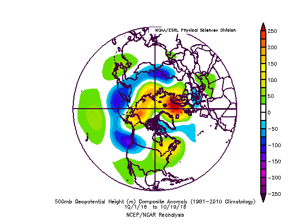
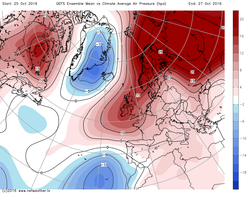
Also the Polar Vortex, which tends to strengthen as we head through autumn and into winter, has been unusually weak in the stratosphere and troposphere so far this autumn. This has worked in tandem with aforementioned recent poleward heat transport to bring the blocked ridging patterns/positive heights in high latitudes, while troughing/negative height anomalies have been apparent in mid-latitudes, such as southern Europe. As a result, the AO (Arctic Oscillation) has dropped into negative territory since early on in the month. The NAO (North Atlantic Oscillation) has been positive recently, due to lower pressure near Greenland and Iceland, though is forecast to head into negative, as the positive height anomaly developing over western Europe later next week retrogrades NW over the N Atlantic and toward Greenland.
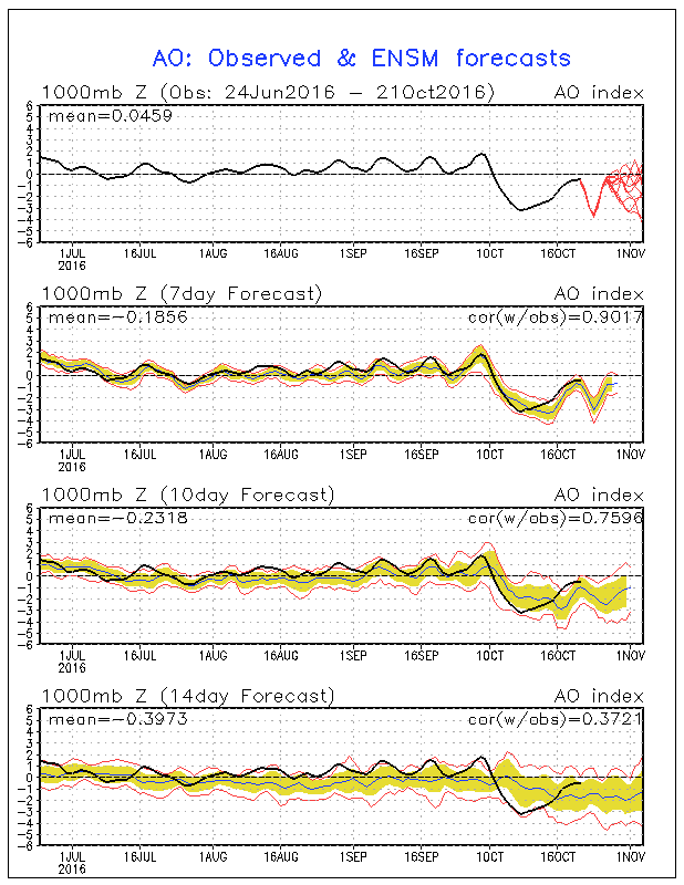
Medium to longer range forecasts taking us into early November hint that the AO will remain negative , with the NAO perhaps trending negative too. This indicates a continuation of high pressure blocking at higher latitudes (northern Europe and/or Greenland) while troughing is more prominent at mid-latitudes (southern Europe). This -AO signal and the weak Polar Vortex may even persist through to early December – which would result in a greater chance for cold and wintry weather for the UK – should the high pressure blocks position favourably.
Record low sea ice levels in the polar region to start the autumn may also help the negative AO persist through November too. Warmer Sea Surface Temperature (SST) anomaly over the North Atlantic compared to last year may also tend aid in a weaker polar front jet stream over the North Atlantic, because the temperature gradient won’t be so pronounced as last year. There is other drivers such as the Quasi-Biennial Oscillation (QBO) wind phase, which can affect the strength/speed of the Atlantic jet stream depending on the directional phase of the QBO. But the QBO has exhibited an unusual sudden switch early this year. Despite switching into a negative/easterly phase earlier this year, every 14 months the QBO wind reliably switches direction , the QBO wind suddenly switched back to a westerly again in an unprecedentedly short period of time. Scientists have suggested that a strong El Nino last winter and rising global temperatures could have triggered the sudden switch, but there is no definite cause yet and there is some scratching of heads to whether this could happen again soon. If the westerly QBO persists, it will tend to work against blocking and favours a stronger polar vortex +AO/NAO signal that would indicate greater chance for mild, wet and windy weather for the UK. The neutral ENSO to slightly weak La Nina conditions in the equatorial Pacific may continue into early winter, though the impacts of this on weather patterns tend to be more pronounced over N America than downstream across Europe.
In a nutshell, there reasonable signs from model output and forecasts, such as Judah Cohen’s, that high latitude blocking/-AO along with the weak Polar Vortex could persist into and perhaps through November and even into early December – which would indicate a higher chance for cold and wintry weather for the UK IF the blocks position favourable and more likely it will continue drier than average across many areas. There are no strong signs yet, of the more usual mobile Atlantic depression/strong zonal jet stream driven wet and windy weather returning anytime soon!


