


Low pressure takes control this weekend, turning it unsettled across all parts. But it looks a brief blip before it turns drier again next week, as high pressure returns.
A pattern change will take place over the weekend from the recent blocked pattern, with low pressure moving in from the west as the persistent anticyclone over Scandinavia retreats.
High pressure over Scandinavia has dominated the UK weather over the past week or more, feeding a cool and showery easterly flow across all parts with nights turning cold with local frosts where skies have cleared. However, the large area of high pressure to our northeast will retreat over the next few days. This will allow a low pressure system lurking to the southwest to move in across Ireland over the weekend, which will bring showers or longer spells of rain to all over the weekend, but also a change of wind direction from a cool easterly to a warmer southerly.
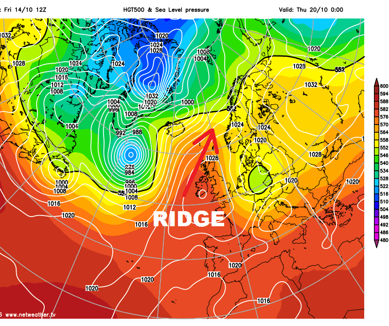
However, the return of Atlantic low pressure influence to bring more unsettled conditions nationwide this weekend looks to be short-lived. The upper pattern looks to become more amplified and meridional again next week (i.e. a trough-ridge-trough pattern across the Atlantic and Europe). The catalyst for this more amplified pattern looks to come about from transportation poleward into higher latitudes of the North Atlantic of warm air into mid-to-upper atmosphere by the remnants of Hurricane Nicole. Ex-Nicole, that passed over Bermuda yesterday as a Category 3 Hurricane, is modelled to move towards Iceland or southern Greenland, it will take warm air wrapped up within the ex-tropical system north with it. The warm air eventually ends up in the mid to high levels of the atmosphere over the far NE Atlantic, Scandinavia, Norwegian and Barents Seas, creating rising heights and surface level pressure to create a blocking area of high pressure over the area.
500mb temperature chart from GFS shows warm air wrapped up with ex-Nicole (NW Altantic early frames) advecting NE toward Scandi
GFS and ECM weather model ensemble mean forecasts and operational forecast indicate the return of a large high pressure block over Scandinavia later next week, after low pressure takes control for a time over the weekend and early next week, This may bring a return to an easterly flow later next week, like we’ve seen recently – with low pressure over central Europe and any Atlantic lows trying to head to Europe prevented from crossing the UK – rather they are forced to slide SE towards SW Europe.
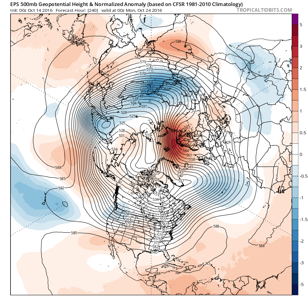
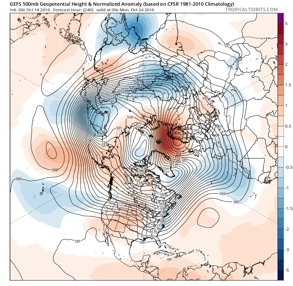
00z ECMWF/EPS and GEFS 500mb mean and anomaly for later next week shows return of block over Scandi
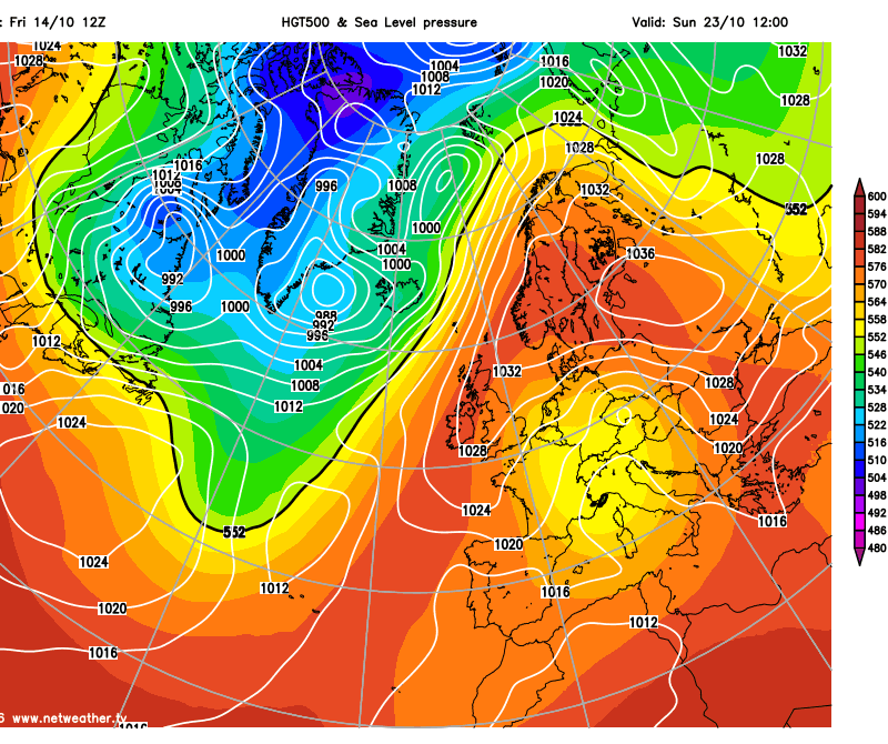
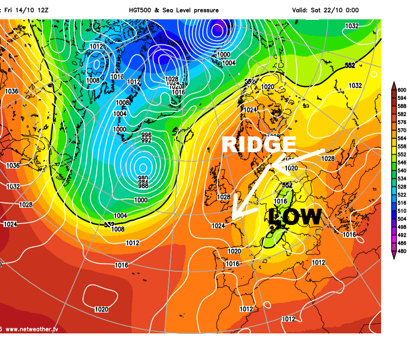
So next week starts with low pressure in control with an area of low pressure drifting slowly NE over western Ireland this weekend continuing to drift NE over Scotland on Monday, with the wind veering westerly and showers generally becoming confined to northern and western areas. While becoming drier and sunnier across the south and east. Then on Tuesday, winds veer to a northwesterly as the low continues tracking towards Norway, so cooler again after the weekend warm up, but mostly dry away from western coasts – where further showers look possible.
A ridge of high pressure builds in from the west by the middle of the week, while troughing digs south to the east over central and eastern Europe – as the upper pattern starts to become amplified gain. So showers perhaps becoming confined to East Anglia and E Kent on Wednesday, dry and sunny elsewhere.
An upper ridge of high pressure then looks to extend NE just west of the UK towards Scandinavia on Thursday and Friday, this created by warm air advection aloft ahead of a deep low pressure system heading towards Iceland containing the remnants of Hurricane Nicole. This warm aloft pooling towards Scandinavia. So by the end of next week, a high pressure block rebuilds over Scandinavia, while an upper low sits somewhere over mainland Europe. So from mid-week we could see winds veer northerly then eventually northeasterly or easterly by Thursday and Friday. This would see the return of showers to eastern areas, while the west stays mainly dry.
So the more typical zonal (west to east) movement of Atlantic low pressure systems close to the UK during October, bringing spells of wind and rain, is looking distinctly under-represented this month.
Will a similar blocking pattern over Scandinavia hold well into November? That’s not something anyone can predict with certainty unfortunately, though high latitude blocking as described over Scandinavia above, may be around still as we head into early November. Any easterlies next month progressively turning colder as landmasses to our east cool down.


