The latest synoptic analysis for the week ahead - 10th October
Key Points
Discussion
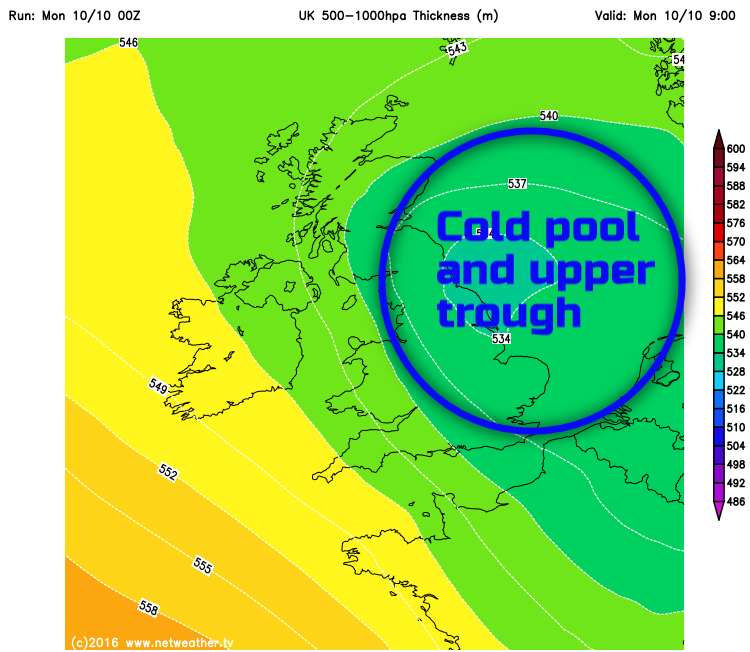
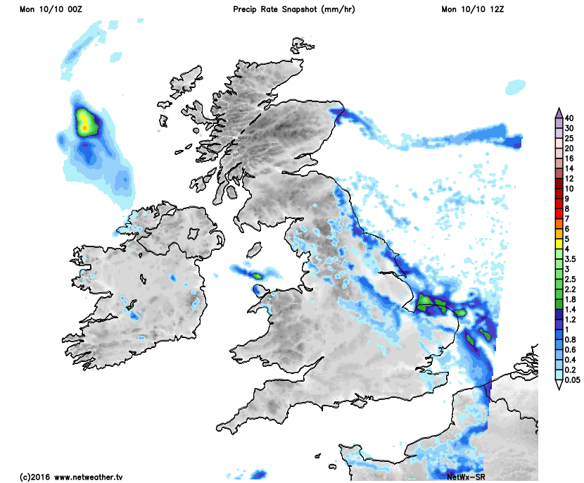
Mon 10th: Forecast model agreement is good regarding the synoptic developments through the remainder of Monday with the main GM’s (UKMO, GEM, GFS and ECMWF) and the HRES models all highlighting an approaching upper trough from the east in association with a region of cold upper air temperatures. This region of colder upper air temperatures, in association with the trough, will combine with above average sea surface temperatures across the North Sea to produce quite an unstable atmosphere. As a result, there is a significant risk of towering cumulus and even CB development moving into eastern areas of England through the rest of Monday, and it is here that the most active weather will be on Monday. There is some focus on HRES output too for the heaviest showers, perhaps with a risk of thunder, to be across parts of E Anglia and SE England and some locally large rainfall totals may well develop in places too, but on a particularly localised scale. For the majority of the UK though, away from eastern areas of England, Monday is set fair after a chilly start with some bright or sunny spells and with variable amounts of cloud. A chilly day, though, especially where cloud is most persistent, and temperatures will quickly fall away this evening as well beneath any clear skies. The region of colder temperatures, in association with the trough, can be seen in the below chart and note some locally heavier showers into E England too.
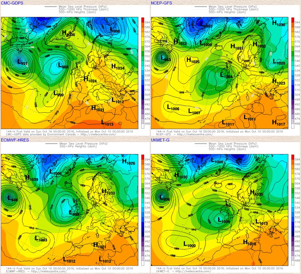
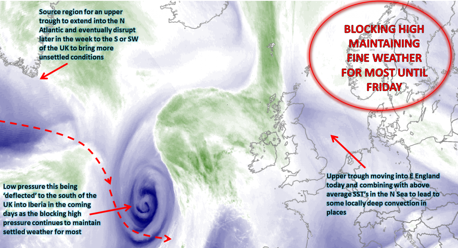
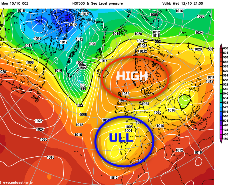
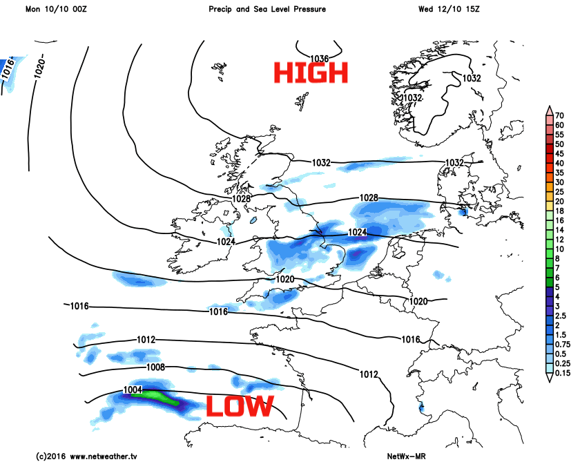
Tue 11th to Thu 13th: Through the majority of the coming week the blocking regime that has dominated for several days now will continue to be in evidence across the UK and NW Europe in general. This will, for the most part, maintain fine and settled conditions, especially across more northern and western areas of the UK beneath a region of higher pressure extending westwards from the main high pressure located over Scandinavia. However, with lower heights and an ULL over Iberia, as signalled by all the main GM’s (EC, UKMET, ARPEGE, GEM and ECMWF) then there will be an increased risk of showery conditions developing, at times, across more southern and eastern areas of England. This progression towards more showery weather is likely to increase as each day progresses with Thursday, currently, likely to be quite cloudy across most areas of central, southern and eastern England with scattered showers, whilst further north and west the generally dry weather is maintained with some sunshine. Using the GFS model, as an example, you can see the ULL to the south of the UK, this influencing the weather across more southern and eastern areas of England, whilst higher GPH is in evidence across Scotland and Ireland in particular. Note as well the signal from our medium range model for showery conditions across some areas towards mid-week and note too quite a strong pressure gradient across the UK in conjunction with the higher pressure to the north-east and lower pressure to the south, so quite a windy period of weather is expected which will accentuate quite a chilly few days too.
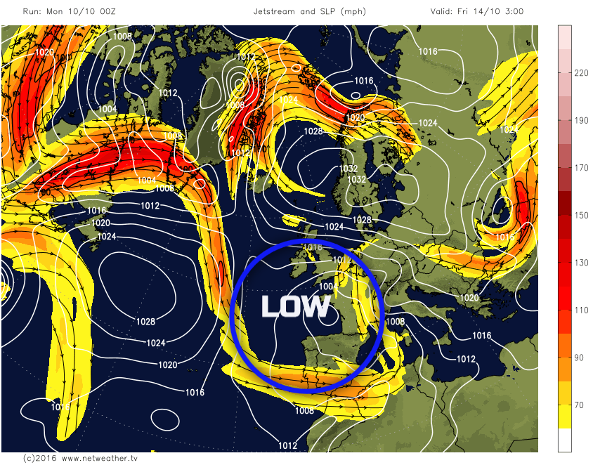
Fri 14th: As we move into Friday and there is then greater model agreement for low pressure to become more influential across a large portion of the UK as our blocking high pressure retreats to the north and north-east of the UK. Some form of trough extensive within the N Atlantic will combine with the ULL to the south of the UK to introduce a larger and more substantial low pressure system just to the south of the UK and with a greater trend for lower GPH and generally more unsettled conditions to develop. It is a well-known occurrence mind that the breakdown of such a prolonged blocking pattern often comes with uncertainties and this evolution is no different. A ‘simple’ breakdown to more unsettled conditions from the west would have brought generally higher confidence over the expected weather. However, with quite a complex evolution taking place, all directly associated with a cut-off upper vortex just to the south of the UK, then the details of the weather by Friday and beyond are indeed very uncertain. However, it would seem that with the low pressure becoming dominant to the south of the UK that Friday will produce a more widespread risk of rain and showers, perhaps with some frontal precipitation in evidence in places too to bring longer spells of rain, it is exactly where most of the precipitation will be that is uncertain. Despite a rise in 850mb temperatures too than compared with earlier in the week, the generally cloudier, wetter and more unsettled conditions, along with a moderate or fresh E or SE’ly wind will maintain quite a chilly period of weather through the day.
Sat 15 the and Sun 16th Oct: Into next weekend and overall the main GM’s including the UKMET, EC, GFS and GEM all signal the ULL continuing to be in evidence either over, or most likely just to the S or SW of the UK. The one main difference is the GEM model which allows for a greater build of pressure once again over the UK in association with trough disruption to the west. However, this is considered an outlier run from the set of Midnight models. The GFS, UKMET and EC all are in broad agreement, as are the EC and GFS ENS with regards to this broader synoptic pattern. As a result despite high pressure still being in evidence to the north of the UK it is more of a cyclonic pattern that is expected to be maintained over the UK through next weekend and hence the unsettled period of weather that develops at the end of the coming week is likely to be maintained into next weekend too. As with Friday though the details are uncertain, but showers or longer spells of rain are possible, perhaps with some slow moving regions of showers or frontal precipitation, depending on the finer details. The rather windy spell of weather may also continue too, but of which isn’t anything untoward for the time of year. So, after what will have been a particularly prolonged period of settled conditions, due to the blocking regime, it certainly looks as though from Friday and through into next week that more unsettled conditions will dominate. However, given the synoptic evolution that is set to take place, then there is certainly some reservations over the details and how much rain will materialise, whether through convective processes, frontal precipitation or both. The details, as ever, will come with time, but for now a broad-brush approach for next weekend is to highlight a generally unsettled picture across the UK with some rain and showers at times, perhaps especially across more southern and western areas of the UK and despite average temperatures the progression towards more unsettled conditions is likely to maintain quite chilly weather overall, but with generally milder nights most likely.