Southern UK this week taps into some of the record heat that's bothered Spain, before the supply of heat is cut-off by the weekend heralding more autumnal weather to take over.
Summer has returned this week, as a plume of hot and humid air spreads up from Spain and France and we are likely to break the date record for maximum temperature on Tuesday, as temperatures hit the low 30s across SE England.
The extreme heatwave that gripped parts of southern Spain last week has eased over the weekend, and it will cool down even further this week from the Atlantic, as storms or heavy rain followed by fresher air moves in. At the same time, some of this heat departing Spain will spread north across France and southern UK over the next few days.
Last week, more than two dozen weather stations in the south of Spain smashed September heat records, 10 stations recorded temperatures over 44C (111F), one station near Seville recording 45.4C (114F).
Temperatures last Tuesday were reaching the mid 40s across southern Spain

The heat eased at the end of last week and over the weekend highs reached a more comfortable 25-32C across much of the country. It will cool further over the next few days, as an amplifying Atlantic upper trough extends SE towards SW Europe before it disrupts - which then allows an area of low pressure to form over the Bay of Biscay along a cold front edging in off the Atlantic. This falling pressure and cold front moving in from the west will trigger an area of thunderstorms and heavy rain to spread west to east across Iberia later today and through Tuesday, followed by cooler and fresher Atlantic air.

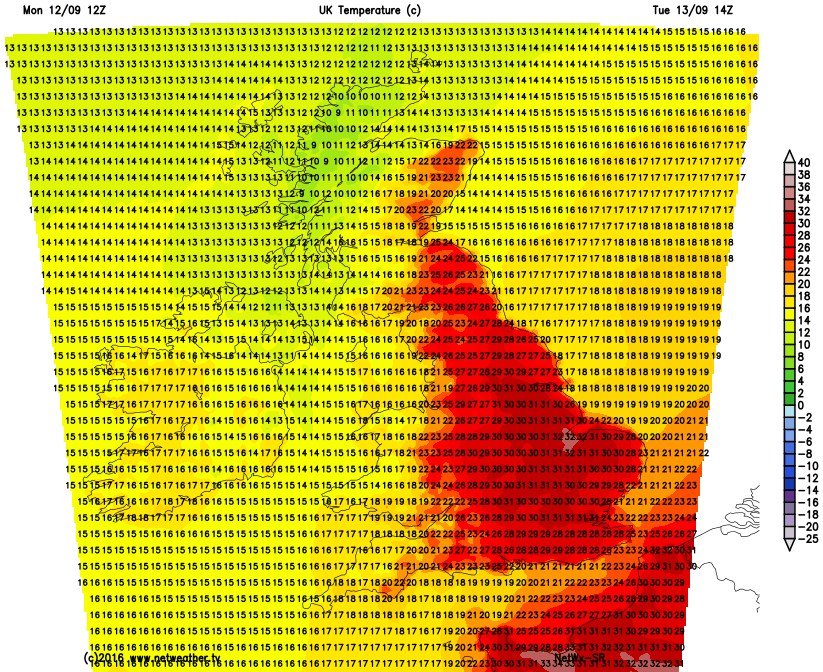
The upper trough and developing low pressure over SW Europe and Bay of Biscay will kick out the heat from Spain across France into southern Britain via southerly winds over the next few days. So on Tuesday, it will become hot and increasingly humid towards eastern England – with somewhere likely to reach 31C (88F). This will break the Sept 13th date record for maximum temperature. The record stands at 28.3c and dates back to 1934.
2m temps for Tuesday afternoon

The heat and humidity sticks around through Wednesday and Thursday across much of England and east Wales – with temperature reaching the mid to high twenties.
But by the end of the week, it looks like cooler and fresher conditions from the Atlantic will return across all parts, as the low over Biscay migrates NE across France and cuts-off the supply of heat from the near continent.
Before the breakdown, there is an increasing risk of heavy thundery downpours developing across the west along a slow-moving and wriggling cold front here during the week. Then as that low over Biscay passes close to the south and the frontal boundary to the west is dragged east with it, isolated storms could develop on Friday across the south for a time too, though less certainty of this. But for many it will be dry away from the west.
ECMWF and NCEP (GFS) ensembles for London show the cool down from the weekend lasting through next week, accompanied by an uptick in rainfall
London 2m temperature

London rainfall (mm)

Looking further ahead once the cool down kicks on Friday, it looks like more autumnal conditions setting in from the end of the week through into the second half of September, as the jet stream, which is currently slow and waving, becomes more zonal as a large polar upper cyclonic circulation drops down from Greenland close towards the UK. GFS and ECMWF ensembles into the medium range indicate temperatures falling from their spike this week to more average values back into the teens for London from the weekend and through next week. Also the ensembles indicate an increase of rainfall in the means, indicative of a more unsettled Atlantic flow from the west or southwest. There are some differences in operational runs though, with today’s 00z and 12z ECMWF run showing warmth returning towards the end of its medium range output as troughing stalls and amplifies to the west. But certainly looking like turning cooler and more unsettled for all from the weekend, perhaps more like proper autumn weather next week, if the GFS is to be believed.