The first of a regular weekly guide to the forecasting models for the week ahead.
Issued at 0900BST on Monday 12th Sept based on 12th Sept 00Z Model Runs
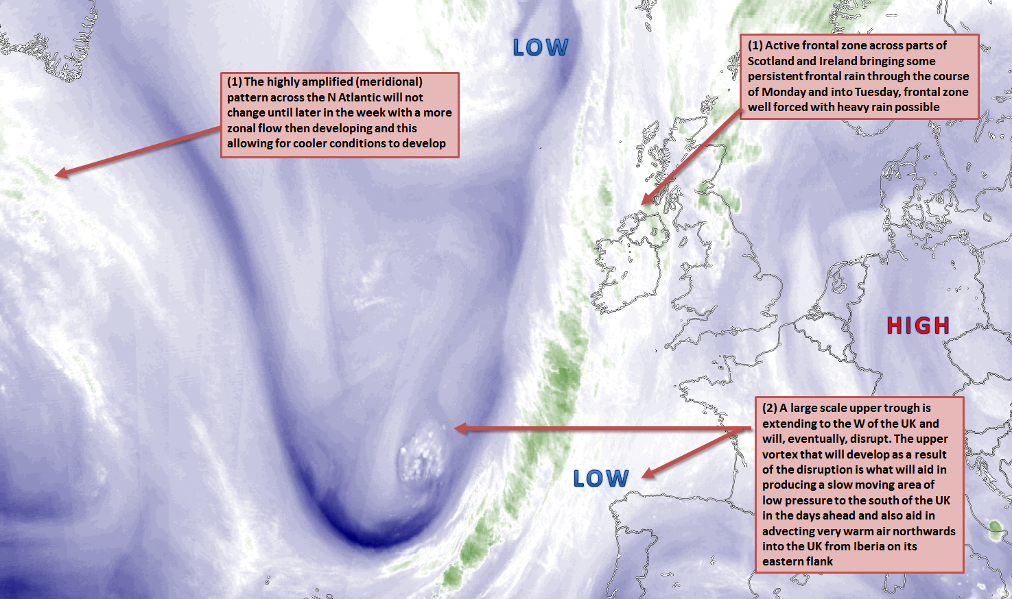
Mon 12th: Forecast model agreement is good regarding the synoptic developments through the remainder of Monday with the main GM’s (UKMO, GEM, GFS and ECMWF) all highlighting quite an active frontal zone across more western areas of the UK of which is tied in with a deep area of low pressure to the NW of the UK. Accompanying this frontal zone is a strong pressure gradient and of which is leading to some very strong and gusty S or SSW’ly winds across Scotland and Ireland. The frontal zone is, at times, well forced so some heavy rainfall is possible and perhaps along with some orographic enhancement in places too. In contrast most of England and Wales will experience quieter and more benign conditions with some sunshine and variable cloud, but showery weather, ahead of the main frontal zone may develop across Wales and SW England at times, mainly from mid-level activity. An increasingly warm and humid air mass, with 850mb temperatures >10C will develop from the south through the day with good model agreement over this.
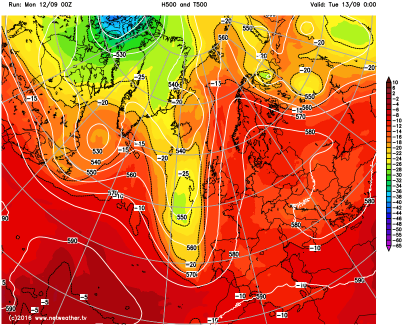
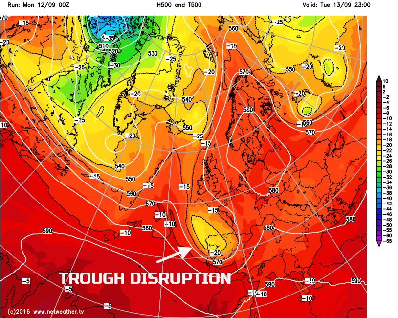
Tue 13th: Into Tuesday and the main development of interest is that of trough disruption to the SW of the UK and a resultant development of a surface low pressure. A warm frontal zone, as signalled by the majority of the GM’s, will still be in evidence across parts of Scotland, Ireland, Wales and SW England during the day. Associated with this will be some extensive frontal cloud layers. Latest model data highlights the potential for more pronounced regions of vorticity to extend northwards from the developing low and allow some intense precipitation to develop across parts of E Ireland, Wales and SW England during the day. The warm frontal zone may also re-active too across more northern areas of the UK, especially across W Scotland later in the day, the GEM model in particular highlights this. All forecast models continue to highlight significant WAA from the south to the east of the developing surface low pressure with 850mb temperatures in excess of 15C across England and Wales, but with much lower values to the west of the warm front across W Scotland and especially Ireland. The interaction of the vorticity filaments and the frontal zone is a complex one, so the exact location of the heaviest rain and showers through Tuesday has rather low confidence with definitely some model divergence over where the heaviest precipitation will be. Worth noting too that some higher resolution models (ARPEGE for example) allow the very warm and humid air mass across England to destabilise just to the east of the surface front, so there is a risk, albeit small, of some heavy and perhaps thundery downpours across SW England, W Midlands and up into NW England later in the day.
Wed 14th: Into Wednesday and the UKMO, GFS, GEM, ARPEGE, JMA and ECMWF are all in broad agreement for an area of low pressure, circa 1004mb, to be located just to the south of the UK with still a slow moving frontal zone across Scotland and Ireland. This will remain a focus for frontal cloud and some patchy precipitation across Scotland and Ireland, primarily light rain or drizzle, but by Wednesday forcing associated with this frontal zone, for now at least, is generally far less significant than compared with Tuesday hence little risk of any heavy precipitation.
The majority of England and Wales continues to be located beneath a warm sector, a significant one at that, with 850mb temperatures still forecast to be at or above 15C, perhaps peaking near 18C across some southern and eastern areas of England, an extremely warm air mass indeed for the time of year. At the moment there is little signal for any convective development across England and Wales from any of the forecast models, so, overall, most of England and Wales looks to have a dry day on Wednesday with some bright or sunny spells and it will be very warm humid indeed. An approaching cold front, which is modelled from most of the main GM’s, may enhance the risk of some showers or thunderstorms into southern counties of England later in the day, but overall many areas should be dry.
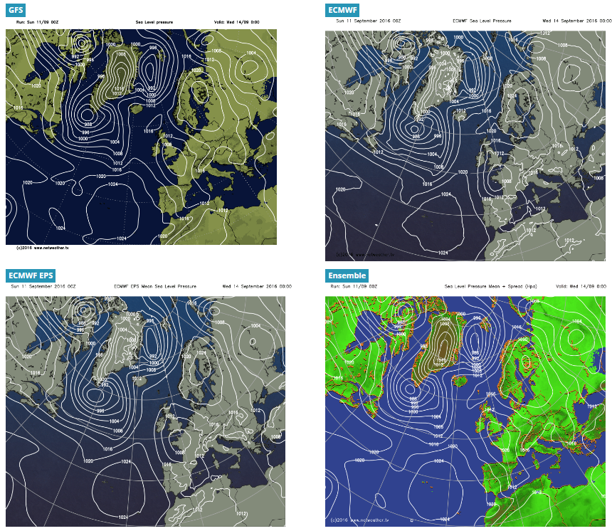
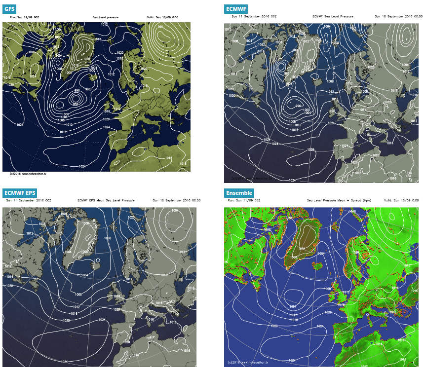
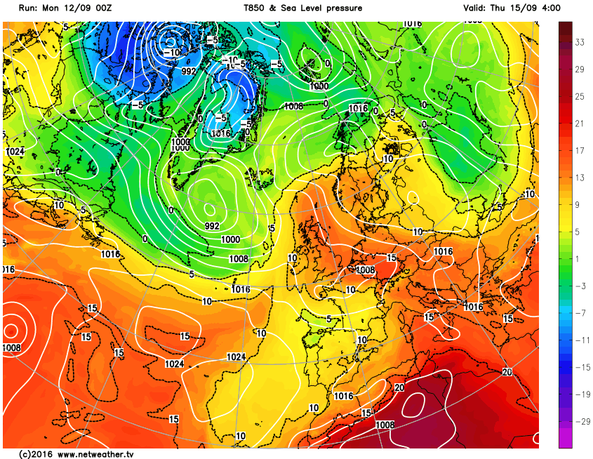
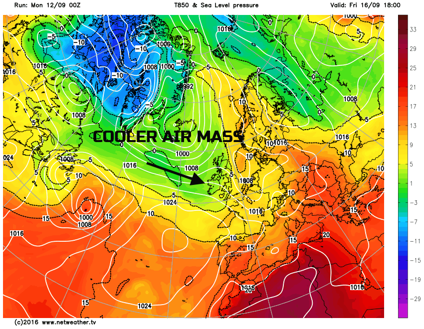
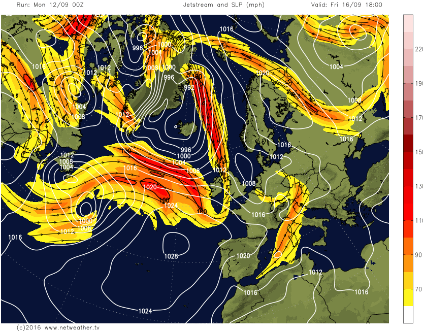
Thu 15th and Fri 16th: The evolution towards the end of the week does have some uncertainty surrounding it, primarily because of the attempted resumption of a more mobile flow across the Atlantic as a more active jet moves out of E Canada in association with a developing marked thermal gradient. Latest GM’s indicate a general amalgamation of the low pressure just to the south of the UK on Thursday with advancing frontal systems and lower pressure from the west on Thursday. This brings an awkward mix of frontal precipitation but perhaps with some convective development too. Most of England and Wales may well have further dry weather on Thursday with some bright or sunny spells, but with an increasing risk of heavy showers or thunderstorms developing from the west as the day progresses. One thing that does have high confidence though is that despite a complex synoptic evolution through Thursday, as we move into Friday frontal systems from the west will have cleared to the east and removed the very warm and humid air mass across the UK with a much cooler and fresher Atlantic air mass in place. So, showers and longer spells of rain are likely to develop from the west through Thursday in association with what look to be quite active frontal zones, before Friday then sees a showery regime develop in conjunction with a polar maritime air mass. This evolution away from the very warm and humid conditions to a more zonal type with showery weather by Friday is highlighted well on the below images from the GFS, for example.
Sat 17th and Sun 18th Outlook: Into next weekend and a rather cool and showery start to the weekend is currently expected, but there are some model differences. The GFS, GEM and ECMWF all have a more troughed pattern over the UK highlighting a greater risk of showers and perhaps longer spells of rain into Saturday, but the UKMO has a more ridged pattern, this is being dismissed for now with a cool and showery Saturday likely at the moment. Into Sunday and all main GM’s have a low pressure developing to the west of the UK, but WAA ahead of this allows for a transient ridge to build into the UK into Sunday, or perhaps from late Saturday. As a result, at the moment, Sunday may well be the better day of the weekend with some mainly dry and fine conditions developing, ahead of perhaps some wet and windy weather across Scotland and Ireland late in the day as frontal zones associated with the low pressure to the west then move in.