
An unseasonably deep depression moving across the north on Saturday brings an early taste of autumn with wet and windy weather this weekend. But, there are increasing signs that summer heat will return next week.
The weather has been rather topsy-turvy this summer in Britain, a consequence of the jet stream having been overhead or nearby and active at times for much of the season. So we had a very brief hot spell back in July between the 18th and 20th. Followed by more unsettled and, at times, cool weather that even brought some frost overnight. However, since early this month, which started on a wet note. It’s been fairly dry and settled for many.
Provisional figures suggest that England, Wales and Northern Ireland have been much drier than average so far this month, while temperatures have been generally close to average, despite some chilly nights. After the warm and dry week so far across many areas and the dry conditions since early on in the month, we see a change in weather from Friday, as an unseasonably deep depression for August winds up and whizzes across northern Britain on Saturday. The deep low will bring strong winds over England and Wales, on Saturday, perhaps gusting to 60mph, along with spells of rain or showers tomorrow and over the weekend. The rain will probably be welcome news to gardeners, who like me, are having to do a lot of watering to keep the plants healthy. So the rain is perhaps welcome, but the strong winds probably not for most.

But if you are worried that we are sliding into the beginning of an early autumn with no return, fear not, because there are signs from recent model runs that a plume of very warm or even hot air will spread north mid-to-late next week. Mind you, for a time, it did look there would be a brief heatwave with temperatures reaching the low 30s early this week. In the end, the heat was downgraded, but it was pleasant enough nonetheless, with temperatures reaching the high 20s.
So it's Thursday evening, and a deepening area of low pressure is brewing out over the Atlantic to the SW of Ireland under the developmental left exit region of a strong jet stream. The left exit of the jet is where upper winds diverge, creates a vacuum that is filled by air convergence at the surface, thus creating falling pressure towards the surface. The low developing at the head of a rather active jet streak across the Atlantic – which can be traced back to Nova Scotia in NE Canada, the strong jet driven by a steep temperature gradient between cold polar air flooding down from Greenland and warm/moist tropical air flooding up from eastern North America and the Bahamas.
Jet stream and surface pressure 18z Thursday evening:

Water vapour imagery shows dry upper air intrusion of jet stream ploughing into the back of deepening low to SW of EIRE this evening:

The weekend low looks like it be at its deepest central pressure on Friday evening just to the west of Ireland, 12z ECMWF as low as 981mb at 18z, GFS has 984mb. Thereafter, the low slowly fills and tracks northeast to be over N. Ireland around midday Saturday, then across southern Scotland by Saturday evening. Tightest isobars and thus strongest winds will be on the southern side of the low’s track across England and Wales during Saturday, with southwesterly veering westerly winds gusting to 40-50mph, perhaps as much as 60mph with exposure over southern and western coasts and hills. These sort of winds wouldn’t cause too much bother in late autumn and through winter, but with the school summer holidays still in full swing for England and Wales, the potential for impact of these strong winds is higher. Combine the wind with spells of rain or heavy showers passing through, it won’t be all that fun being outdoors for long periods and it may make for tricky driving conditions too.
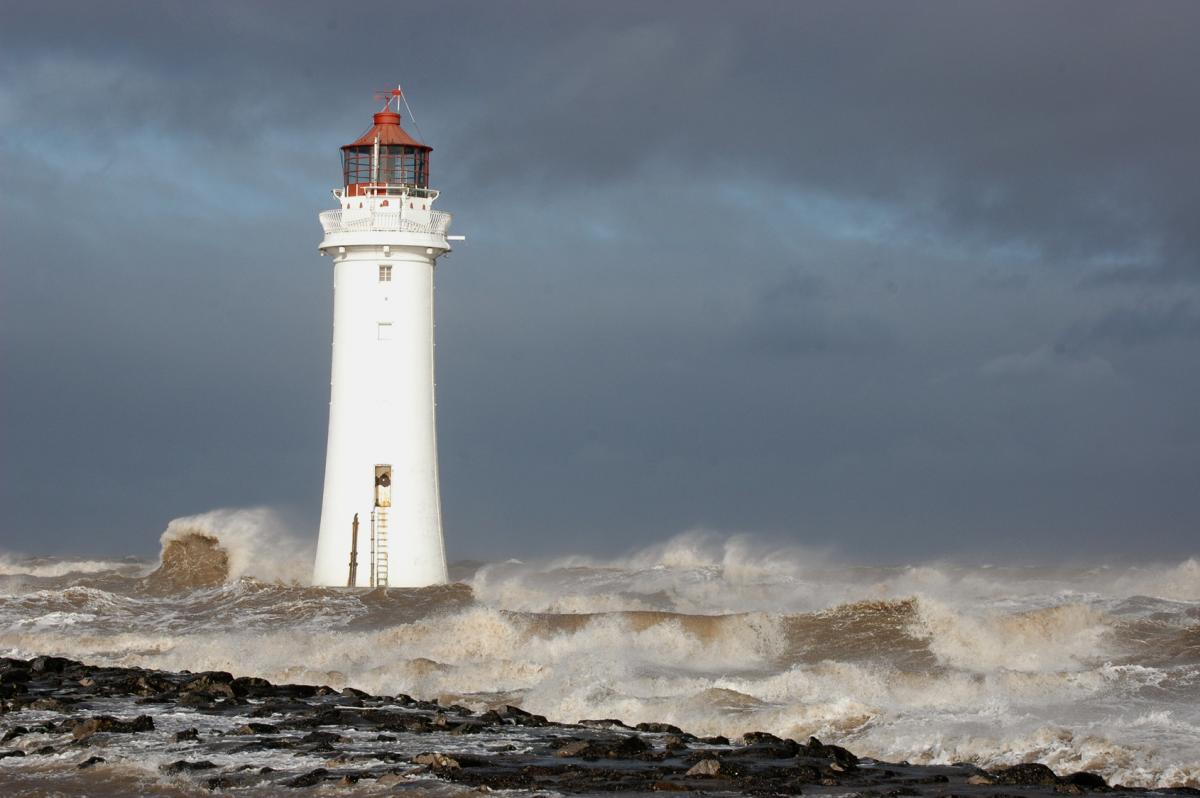
And with a full moon at the moment, when the sun and moon are in line with the earth and have greatest combined raising effect of the oceans, spring tides combined with strong winds will create large waves along southern and western coasts of England and Wales exposed to the wind. So worth bearing in mind if you are planning to take a ferry or simply visiting the coast. UK Met Office currently have weather warnings in place for wind on Saturday.
Low moves away on Sunday, but showers continue and more general rain arrives later in the day to bring a wet day for England and Wales Monday:

The deep low moves away on Sunday and although winds will ease, there will be further showers passing through across many areas. Then a longer spell of more persistent rain looks to spread across SW England and Wales in the evening and overnight while spreading further east into Monday. So a wet day showing for Monday, GFS indicating 100mm+ rainfall accumulation by the end of Monday across higher parts of North Wales.
Plume of hot air spreading north from mid-week? Not nailed yet, but don't give up on summer returning:

However, by the middle of next week it’s drying up and warming up. The models are beginning to converge on the idea of the upper trough to the west of the British Isles amplifying southwards while an upper ridge of high pressure builds northeast across western Europe including the south and east of Britain. As a result, much warmer and more humid air looks to be drawn north across the UK. By Thursday afternoon, 12z GFS shows temperatures as high as 32C across SE England, mid-to-high 20s elsewhere across England and Wales.
So don’t give up on summer yet, though next week’s potential heatwave showing may be downgraded nearer the time.


