
Blog looking at why we are only seeing brief one day bouts of heat this summer, despite some recent tabloid headlines of a 'Heatwave For Two Weeks' on the way.
You may have seen the tabloid stories a few days ago, mentioning no names, of a ‘Heatwave For Two Weeks’ on the way starting next week. Sorry to disappoint those taken in, but that’s looking unlikely. Yes, the temperatures are rising from tomorrow, culminating in temperatures nearing or perhaps exceeding 30C (86F) in the south on Tuesday. Before an Atlantic frontal system sweeping in from the west, probably Tuesday night into Wednesday, sweeps the heat away east, with some heavy rain and thunder during the transition. Three fine days and a thunderstorm. Then back to the cooler, fresher and changeable conditions that have dominated this summer.
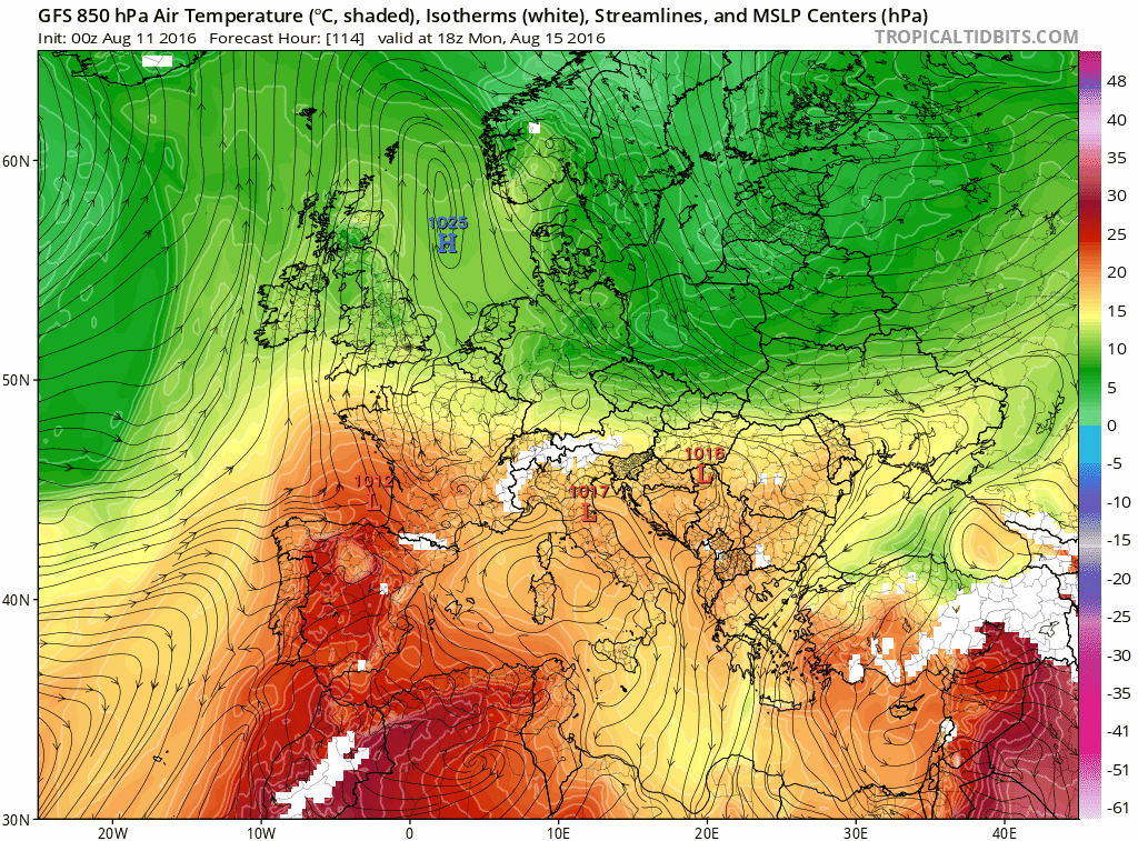
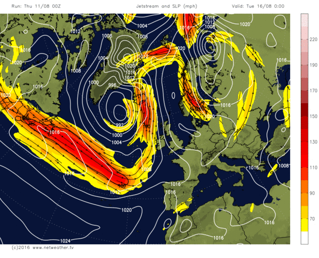
Plume of heat briefly drawn north across the UK early next week
Since 2006, the UK has seen a run of seemingly rather indifferent or even poor summers – i.e. often cool, unsettled and wet at times. But how bad have our summer been since 2010? It’s easy to look through rose-tinted spectacles to the years when summers were seemingly characterised by long spells dominated by high pressure bringing protracted spells of dry, sunny, very warm or hot weather and say ‘what ever happened to our summers?’. Certainly, there were such summers in more recent years such as 1989, 1990, 1995, 2003 and 2006. But those summers in the years in between weren't as good, though the odd month in these summers could be summarised as being dry and very warm with the odd heatwave thrown in.
However, the last few summers, it’s been a struggle to get just one or two days of proper warmth or heat (i.e. temperatures of greater than 80F (26.6C)). This summer, so far, we had to wait until a brief hot spell between the 18th – 20th July – when we saw the temperature reach 33.5C at Brize Norton (Oxfordshire) on the 19th. Next week promises warmth building to bring one day of heat next Tuesday before it breaks down on Wednesday. Last summer saw average temperatures in June, a slightly cooler average July – despite a one day ‘heatwave’ bringing a record July maximum of 36.7C at Heathrow on the 1st, followed by a cool, unsettled and dull August.
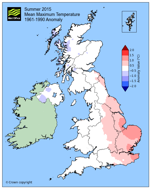
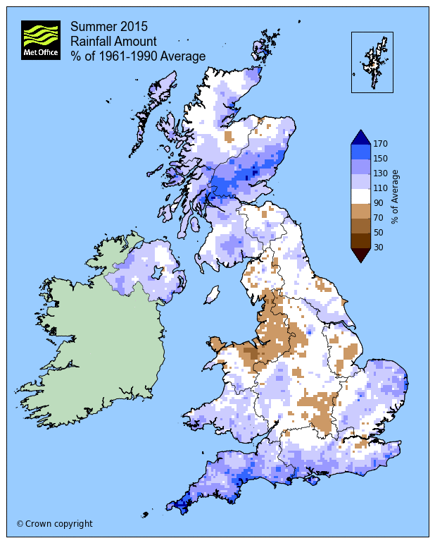
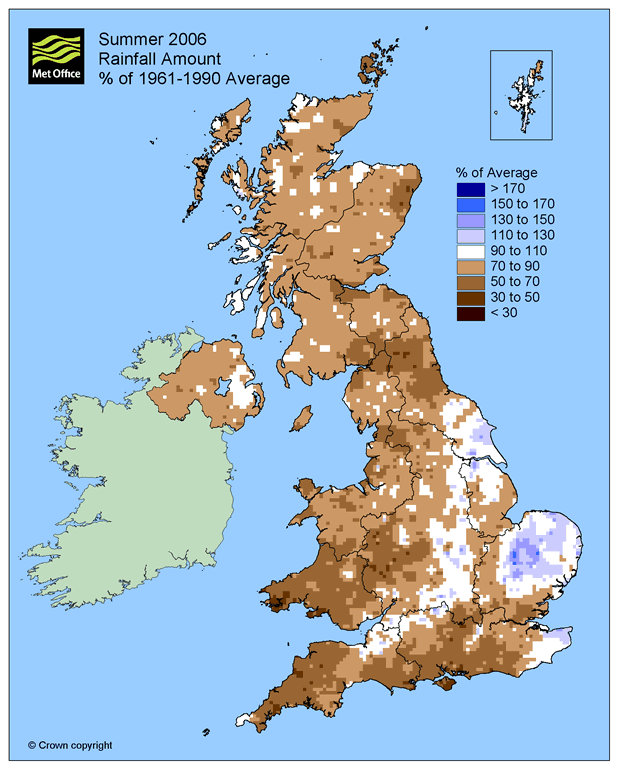
Summer 2015, average temps generally, slighter wetter than average away from central parts (images courtesy of UK Met Office)
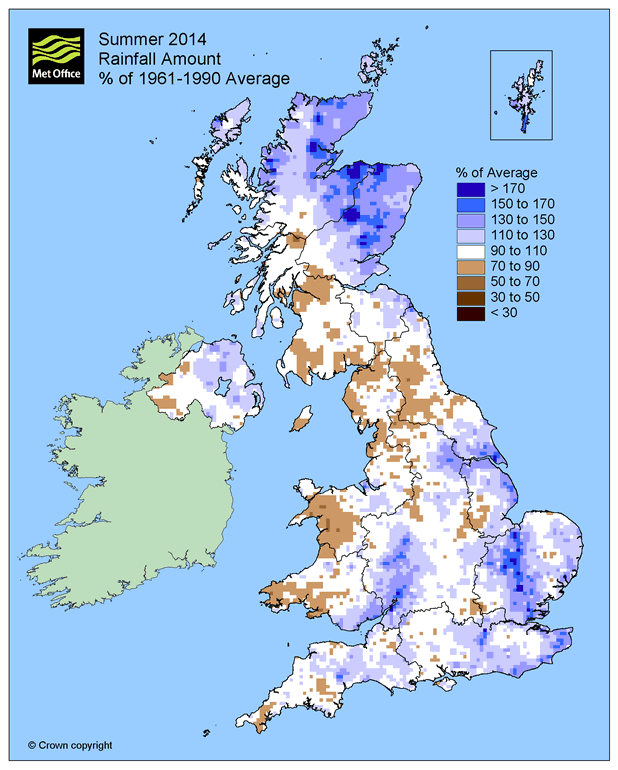
Summer 2014 we fared somewhat better, with June and July warm and sunny on the whole, but spoiled by cool and wet August. Summer 2013 wasn’t too bad, I think, how our memories fade so quickly! June that summer was dry with average temperatures, but the best part was July where a proper heatwave (not just a one day wonder) brought temperatures of 28C (82.4F) or more at one or more locations over the 19 days between 6th July and 24th July that year (information courtesy of Trevor Harley’s website). Rose tinted spectacles?
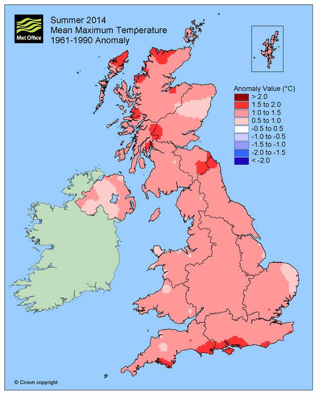
Summer 2014 not all that bad, above average temp wise, though August bit of a stinker (images courtesy of UK Met Office)
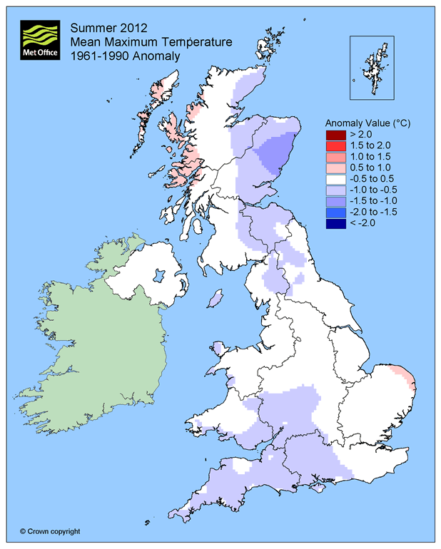
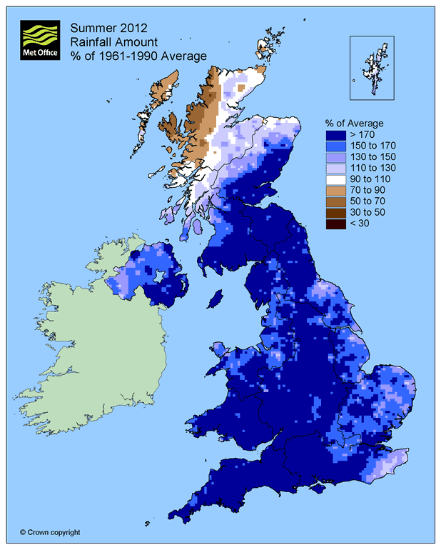
But then there was summer 2012, which was mostly a stinker, the three months were much wetter than average and rather dull too. June was one of the coldest, wettest and dullest on record, wettest since 1860 and coldest since 1991. August did kind of salvage a brief resemblance of summer, with winds often from the south and a brief heatwave midmonth for SE UK. Summer 2011 was rather cool and changeable as a whole, though there were a few brief spells of hot weather. Summer 2010 wasn’t particularly memorable either, a few days where the mercury exceeded 30C (86F).
Summer 2012 was a right stinker, cool, very wet and dull in June and July.
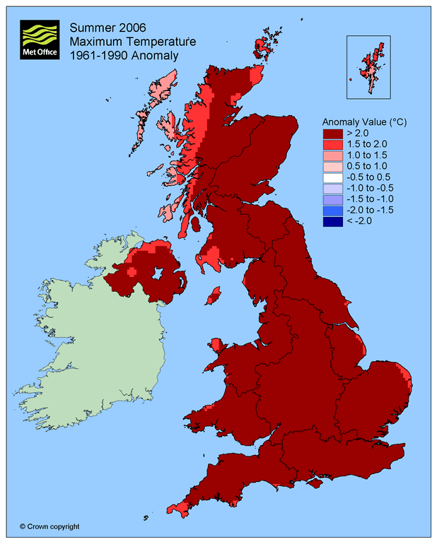
We really have to go back 2006 for protracted Mediteranean style summer weather, June and July that year were dominated by anticylonic conditions (remember a week or more of high pressure in summer?) – which brought warm or hot and very sunny weather most days.
Remember those fine summers? 2006 was up there with them, well June and July at least:
So why have summers recently become generally cool and changeable with only brief glimpses of heat? Well, there was a gathering of scientist and meteorologists at the Met Office in Exeter earlier this year to debate the possible causes for Europe ‘unusual season weather’ over recent years. Their findings found that the UK could be in the middle of 10-20 year ‘cycle’ of wet summers. The last six out of seven summers in the UK have seen below-average temperatures and sunshine, and above-average rainfall.
A possible cause for this ‘cycle’ of poor or indifferent summers could be blamed on the position of the jet stream. This summer the jet stream has often been over or just south of the UK and has been very zonal (i.e. wet to east flow), keeping summer heat bottled-up over southern Europe for most of the time. Occasionally the jet stream has buckled north to draw heat up from southern Europe. But because the jet stream has been strong much of this summer (and recent summers with only brief heat) – these buckles in the jet move through quickly – which means the heat doesn’t hang around for long before it gets pushed away as the buckle moves east. What we’ve also seen is when the buckle in the jet shifts east of the UK, the jet stream upstream slips south, with the UK in a cool northwesterly flow like since the beginning of this week. So although we see average daytime temperatures, the nights are cool or, in the north, even cold with a frost in sheltered valleys.
Ideally, for protracted dry and settled weather and hot spells in summer, the jet stream need to shift north and west of the UK – to allow high pressure to build. This has been rare as hens teeth it seems in recent summers, though 2014 is an exception.
The jet stream buckles north briefly early next week, bringing heat north, before sinking south and turning zonal from mid-week bringing fresher Atlantic air back:
The cause of the jet stream shift further south than the norm in summer over Europe may not be fully understood yet. Though there is research ongoing that nods towards a combination of solar variability, retreating ice/rapid warming over the Arctic creating less temperature contrasts between the pole and tropics along with anthropogenic greenhouse warming perhaps affecting the position of the jet. Although year on year, high temperature records are continually being broken locally and globally, it seems this small corner of the world isn’t in on the heat for now. But in a warming world, not everywhere warms up. Just our luck, if you like continual warmth, that is.


