A blog looking at the brief heatwave peaking on Tuesday across the UK, before a thundery breakdown spreads from the west across northern and western areas on Wednesday, then cooler and fresher conditions return Thursday.

It seems the UK has had a lack of a summer so far following a rather dull, cool and wet June and an indifferent July so far. But the new week sees the UK is facing its first heatwave of the summer so far. Temperatures during the peak of the heatwave tomorrow look to reach as high 33-35C across southern England, 29-31C across northern England, and the high twenties across Scotland. So some may feel it's too hot rather than not warm enough, such is the lack of consistency in the UK weather! Unlike southern Europe where it’s hot for much of the summer, the UK is often changeable thanks to being closer to the jet stream that bring weather systems off the Atlantic.
How long will the heat last?
The heatwave will be short-lived though, as the upper ridge across western Europe bringing fine, settled and increasingly hot conditions edges away eastward later tomorrow to allow an upper trough to move in from the west. This fall in upper pressure or ‘geopotential heights’ aloft allows low pressure to develop at the surface and move northeast across the UK on Wednesday ahead of a surface cold front arriving to the west The lift of the hot and humid air created by this low moving northeast combined with cooling air aloft with approach of the upper trough and some upper disturbances running NE destabilises the atmosphere to lead to thundery breakdown. Thunderstorms during the breakdown are most likely across northern and western areas from late Tuesday through until early Thursday. A cold front moves east on Wednesday introducing fresher conditions across the west, but ahead of it another hot day across central, southern and eastern England, before the cold front clears eastern England Wednesday night to introduce cooler and fresher conditions on Thursday.
Where’s the heat coming from and how hot?
The combination of an upper ridge aloft, surface low pressure stalling to the west of the British Isles and surface high pressure to the east over the near continent draws a plume of hot air from western France and Iberia, where temperatures have reached 35-40C over the weekend.
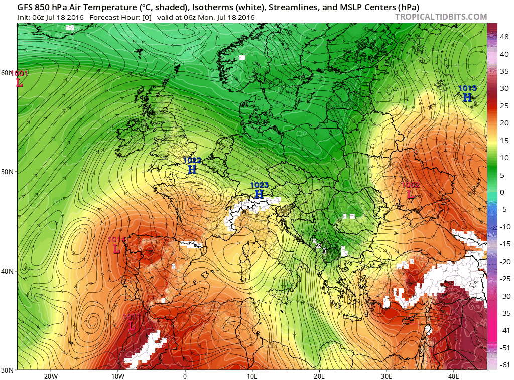
The heat arrives today across England and Wales, with temperatures reaching 24-27C across the north and west, 27-30C towards SE England and East Anglia. Already we have seen the highest temperature of the year so far this afternoon, with 29.7C recorded at St James’ Park in London, outside the city 28.7C recorded at Charlwood in Surrey. Northern Scotland holding on to cooler weather today, thanks to stubborn Atlantic fronts bringing cloudier skies with rain - with temperatures reaching the mid-teens under the cloud. Southern Scotland warmer with drier and sunnier conditions, allowing 20-23C in the sun.
On Tuesday, the heat further south reaches Scotland too, with temperatures reaching the mid to high 20s, while further south, temperatures across England and Wales reach 27-31C widely inland, perhaps as high as 32-34C across southern England and the Midlands. If you think that’s too hot, the heat becomes even more extreme across SW France on Tuesday, reaching 40-41C.
Temperatures on Tuesday afternoon
An uncomfortable night to come on Tuesday night for many, temperatures may not fall below 21-23C across much of central and eastern England, high teens elsewhere. The high humidity levels keeping the temperature falling to more comfortable levels for sleeping.
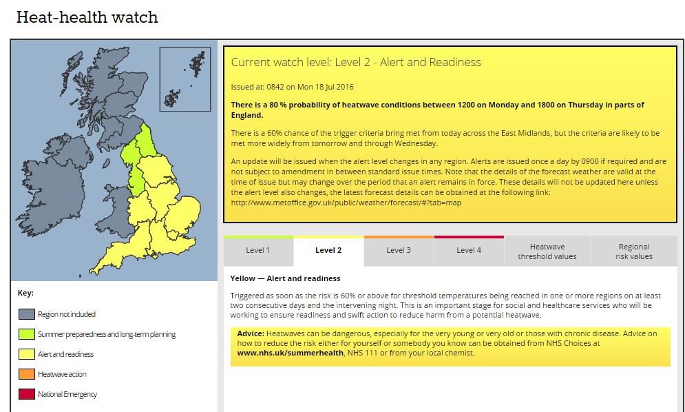
Heat Warnings
UK Met Office have issued a Level 2 Heat Health Watch for England
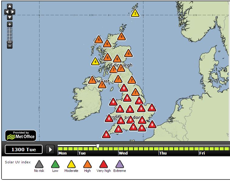
UV Index during the Heatwave
The Met Office says: UV index does not exceed 8 in the UK (8 is rare; 7 may occur on exceptional days, mostly in the two weeks towards the end of June). Indices of 9 and 10 are common in the Mediterranean area.
Tuesday sees indices reaching 8 across much of England and Wales, 6-7 far north of England northward and elsewhere. So it would be very wise to cover skin in sunscreen.
Image courtesy of UK Met Office
Risk of severe thunderstorms as the heatwave breaks down
Northern and western areas look most prone to thunderstorms breaking out from late Tuesday, in response to low pressure developing from the SW and colder air overrunning from the west above the warm humid air - as upper trough edges.east from the Atlantic.
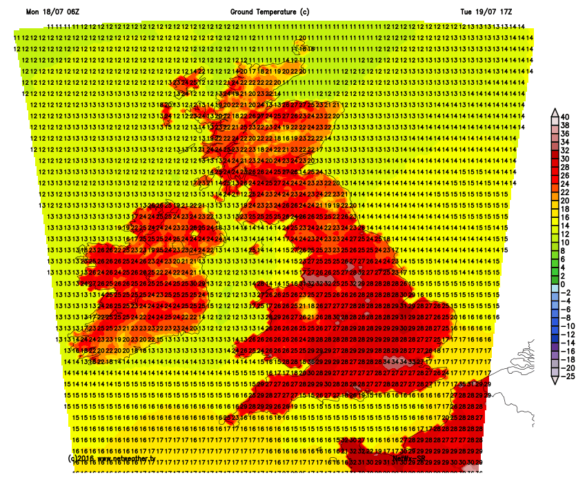
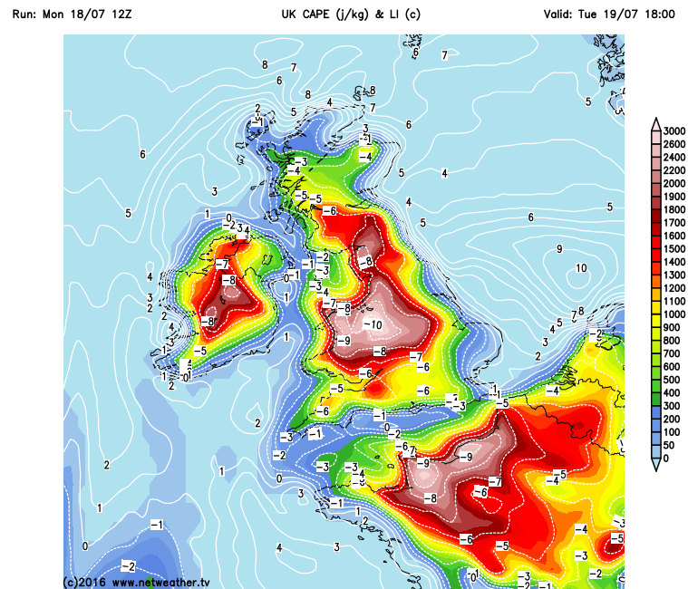
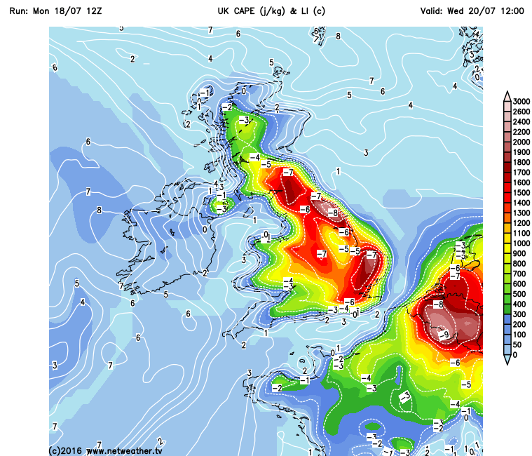
Large amounts of potential instability (CAPE) are forecast to build across the UK on Tuesday, with 1000-1800 j/kg CAPE indicated by GFS across EIRE and central areas of the UK tomorrow afternoon. This energy is likely to be capped by an upper ridge during the day. However, as upper forcing arrives from the west and southwest in the evening, as a shortwave upper trough and falling heights from the west creates lift across EIRE and NW Britain, thunderstorms are forecast to develop across EIRE, N. Ireland, north Wales and NW England through the evening and early part of Tuesday night, before spreading NE across western Scotland early Wednesday. These storms continuing to move NE across N. Ireland, north Wales, northern England and Scotland through Wednesday morning, before easing off across the far west in the afternoon. Storms may also develop further south across south Wales and the Midlands too, but here they maybe more isolated.Storms should clear away from the west during the evening, finally eastwards from NE England and eastern Scotland during early Wednesday night, as a cold front moving in from the west clears the very unstable hot and humid plume out into the North Sea.
High CAPE (Convective available energy) building across the UK tomorrow, the fuel for storms overnight into Wednesday before the CAPE is shunted east on Wednesday
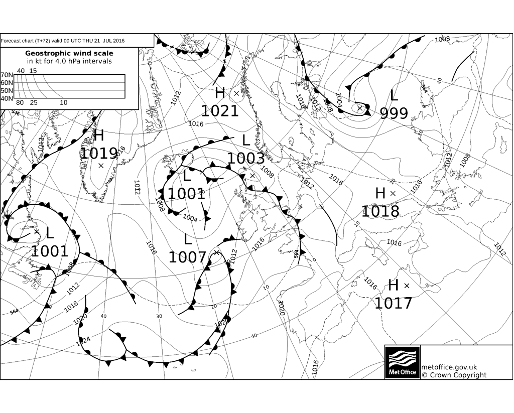
UKMO fax chart shows a cold front clearing eastern England early hours of Thursday, ending the heatwave and taking the storms away with it.
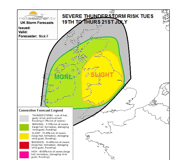
There is potential for severe thunderstorms to develop across parts of Wales, The Midlands, northern England and southern Scotland. Here storms will be an environment of fairly strong vertical shear, particularly low-level shear – thanks to a SEly flow at the surface and a southwesterly flow aloft strengthening with height. This strong low-level shear will favour the development of strong organised storms that may develop supercell characteristics where they remain discrete, capable of producing large hail up to 2 to 3cm, strong downdraft winds, frequent lightning and rainfall rates up to 30mm/per hour in some spots, perhaps 50mm where more than one storm passes. These strong and perhaps severe storms may lead to flash-flooding of highways and property, dangerous driving conditions, disruption to public transport. and interruption to power supplies.
Below is a map outlining what I think maybe the risk of severe thunderstorms across the UK from late Tuesday through to early Thursday. MARGINAL RISK of severe weather EIRE, N. Ireland ... SLIGHT RISK of severe weather over Wales, Midlands, N England and southern Scotland.