
Despite a 'Good Friday', the rest of the weekend is looking rather stormy, with wet and windy weather on Saturday, heavy showers Sunday before rain and severe gales arrive on Monday.
In my last blog I wrote about an omega block dominating our weather up until the middle part of this week. indeed the blocking high slipped away southwestward on Tuesday and Wednesday, allowing an Atlantic frontal system on Thursday, bringing a breakdown to the dry and settled, albeit cloudy conditions that have persisted. The rainfall spreading southeast across many parts on Thursday was generally light, however, waves developing along the cold front arriving across S and SE England Thursday evening and overnight have delayed clearing the rain and also pepped up rainfall.
The rain has cleared off into the near continent, with a brief ridge of high pressure building for Good Friday, bringing fine and dry conditions with plenty of sunshine for many. However, don't be fooled by today's weather, as it's all downhill from tomorrow morning.
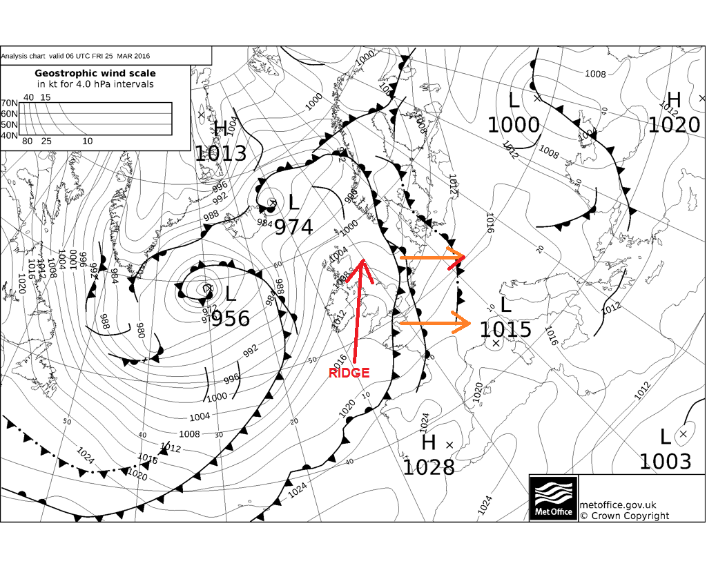
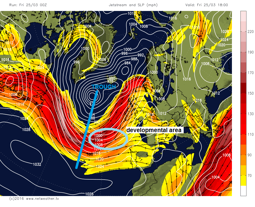
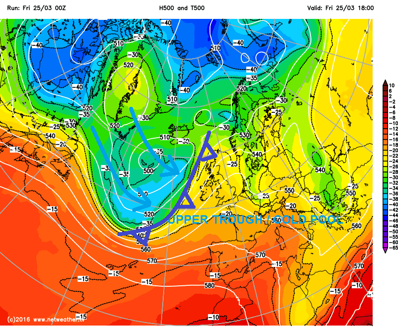
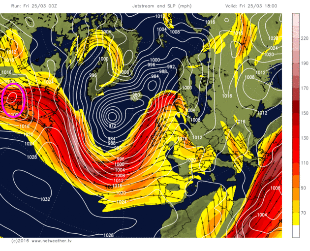
A deep upper trough / cold pool pushing out of NE Canada / Labrador Bay overnight is pushing east/southeast across the Atlantic towards the UK over the next 36hrs, while a strong jet coming out of NE USA and eastern Canada wraps around this upper level trough pushing east. A strong jet streak on the rear side of this trough suggests a diffluent trough (where air slows down on leaving the trough compared to entry) which can lead to major cyclonic development on the forward side of the trough along the frontal boundary separating cold polar and tropical maritime airmasses.
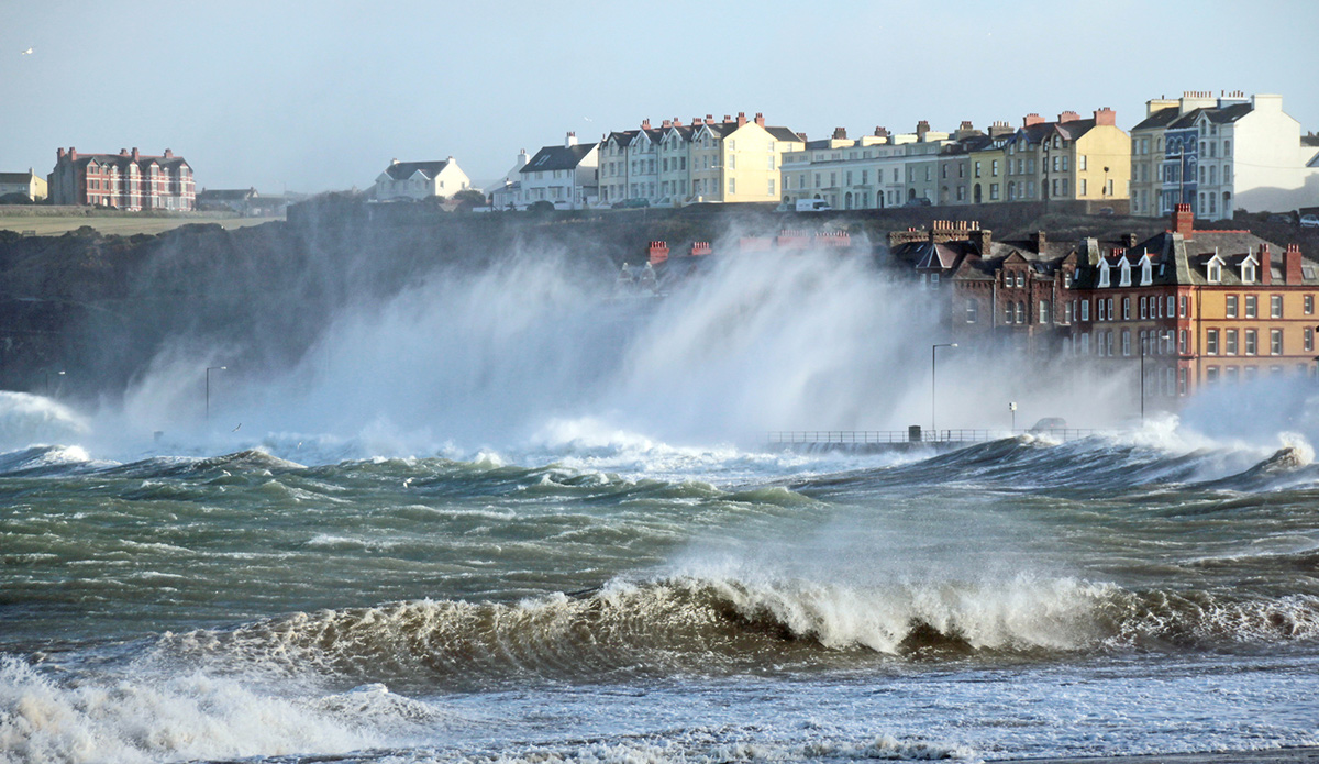
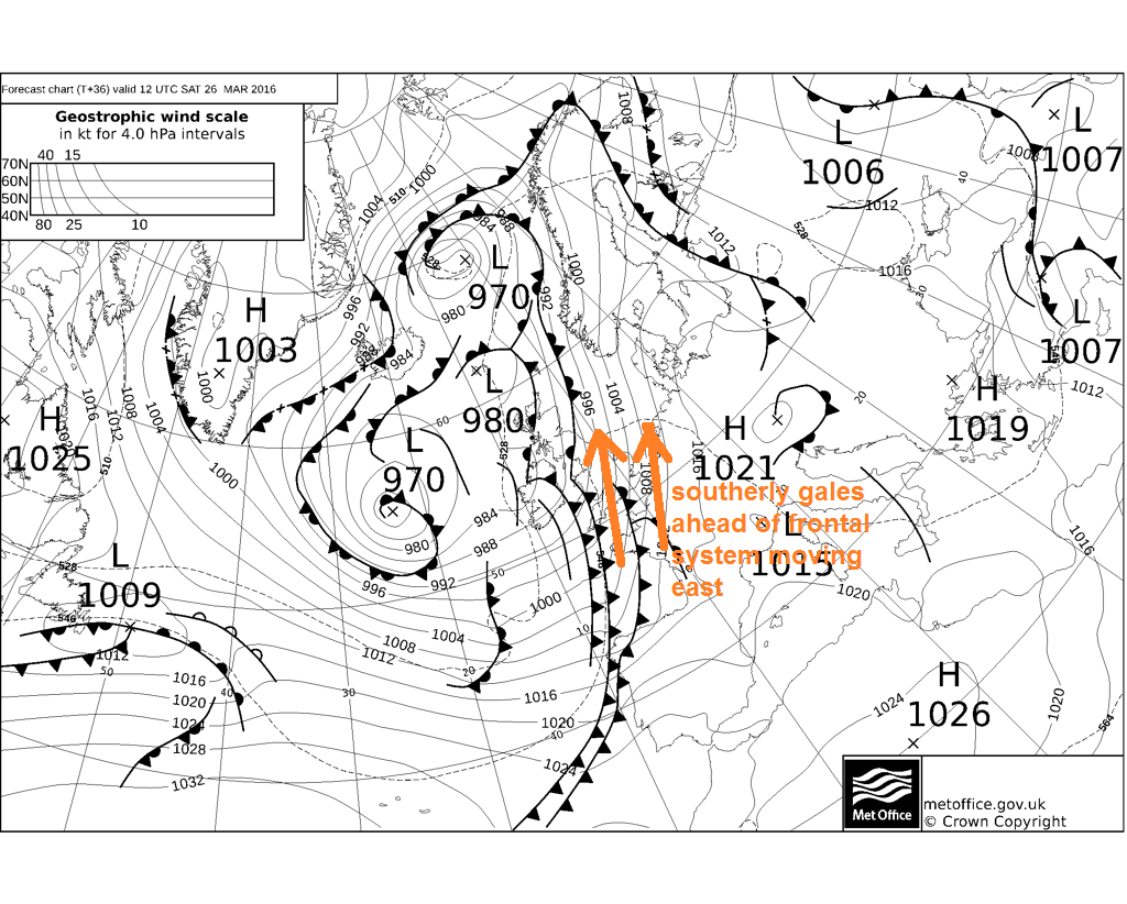
The frontal system ahead of this trough moving in tomorrow does develop a wave depression that deepens slightly as it moves NE across the NW of Ireland tomorrow afternoon then across northern Scotland Saturday evening. However, the wave initially doesn’t phase properly with the sharpening upper trough to the west and exit region of the jet stream to allow too much deepening to bring winds of any concern, though it does finally deepen sufficiently across Scotland tomorrow evening (971mb) off NW Scotland 00z Sunday on GFS) to bring 50-60mph gusts across northern Scotland. However, we will see an active frontal system slide in from the west across northern and western areas during the day, then across eastern areas during late evening overnight. A tight pressure gradient will exist just ahead of the frontal system pushing east, with a swathe of strong southerly winds pushing east across England and Wales ahead of the cold front, with gusts of 45-55mph likely inland, perhaps 55-65mph along southern coastal areas exposed to the wind. This may cause some travel disruption, particularly to cross-channel ferries and delays to flights. Winds should quickly ease once the frontal system and its squally and heavy rain has passed.
Frontal wave moves across NW Ireland on Saturday, before deepening across Scotland Saturday night, frontal system moves east bringing a spell of heavy squally rain with southerly gales ahead of it across England and Wales
In wake of Saturday’s frontal system, which clears eastern areas first thing Sunday morning, a showery polar maritime flow covers most parts on Sunday. With the sun having more strength now only 3 months away from the summer solstice, ground heating beneath cold air aloft will create sufficient CAPE (Convective available potential energy) for clouds to attain enough depth to produce hail and thunder.
It will be windy on Sunday too, particularly towards southern and western coasts, with gusts of 30-40mph possible. But Monday could potentially be much windier across southern areas, with many a forecaster keeping a close eye on upstream developments that are leading to another potential named-storm (Katie?) bringing gales or severe gales across southern and central parts of England during Monday.
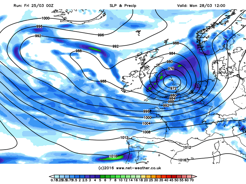
An area of low pressure over the eastern Great Lakes this morning will continue NE today exiting New Foundland tonight. A sharpening shortwave upper trough of cold air moving east out of northern Canada and a strengthening jet streak along the strong baroclinic zone over the NW Atlantic will engage this low and deepen it rapidly as moves east across the Atlantic. The low stays in the highly developmental left exit of a strong jet streak throughout its journey toward the UK. Most models deepen the low substantially on arrival in the southwest approaches before it slowly fills and moves NE/ENE across England and Wales during Monday, exiting somewhere between Newcastle and East Anglia.
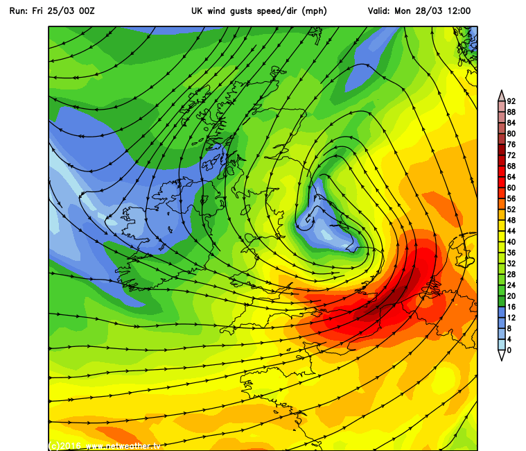
Very strong winds on the southern and southwest flank of this low indicated across southern counties of England and perhaps East Anglia, 00z GFS indicates 60-70mph along the south coast, higher (70-80mph) through the English Channel and land with exposure (such is Needles on Isle of Wight). Very heavy rain pushing NE with this low across much of England and Wales too, bringing a risk of flooding in places. Some strong instability / convective activity possible too where skies clear in wake of this low across southern and eastern England in the afternoon, with strong winds aloft lowering to the surface in any downdrafts. All-in-all, not a pleasant day for those out and about, anyone planning anything outdoors would be well advised to check local forecasts and warnings that will be likely issued soon.
Will try and bring updates on Monday's situation over the weekend.


