In the sunshine this week, it will feel warmer, with temperatures nudging up through the teens, even past 20C. However, the Bank Holiday weekend is looking a bit mixed.
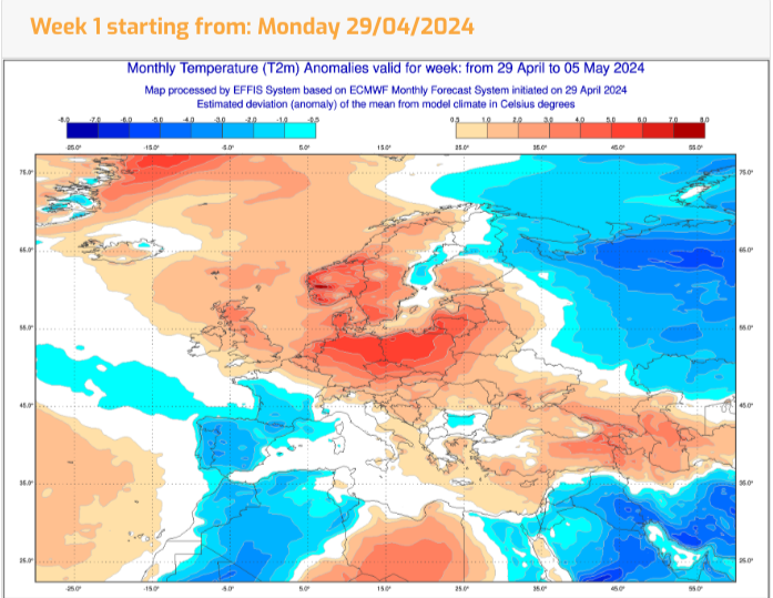
Finally, there are signs of something warmer as we step into May. There is a Bank Holiday weekend coming up, but before you sling your winter coat in the cupboard and get excited about your summer wardrobe, the outlook is still rather mixed.
Manchester will fare well in the easterly wind over the next few days with sunshine and temperatures up to 20C. At the weekend, there could be similar on Saturday if the cloud breaks up and sunny spells appear. Brighton could see 17C on Wednesday as the wind drops out but overall it’s a rather cloudy picture with temperatures around 15C in the breeze at the weekend. Maybe a touch warmer by Bank Holiday Monday. Edinburgh is going to struggle in the E/NE wind off the Forth. After sunny warmth on Tuesday, the next few days will be disappointing, with temperatures in single figures. If the low cloud and breeze off the sea continue at the weekend, it will feel cold but any shift and cloud breaks could result in warm sunshine.
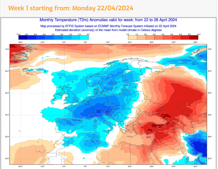
Recently it has felt chilly due to colder air from the north which has been noticeable when the sun goes in or when the wind blows. There has also been a lot of cloud about, those gloomy skies have added to the cool feeling.
Average maximum temperatures: SE and central southern England, April 13.2 C and May 16.7C. For western Scotland, around 10C for April, 13C for May. It’s not supposed to be that warm yet but the cloud cover and wind do make a real difference to how it feels.
April is a contrary month. Those pesky showers bring sudden gusty winds, darkness and downpours before the sun reappears and we’re all confused by the chopping and changing. For the start of May temperatures of 15 to 21C are being mentioned which move us from below average to above average. Away from a cool easterly wind and in any sunshine it will feel different. It could feel warm.
Often when there is talk of things warming up, there is often an assumption that the weather will be sunny and dry. That is not the case. There is still a lot of uncertainty around the early May Bank Holiday weekend weather but there is quite a lot of cloud showing and outbreaks of rain on Saturday.
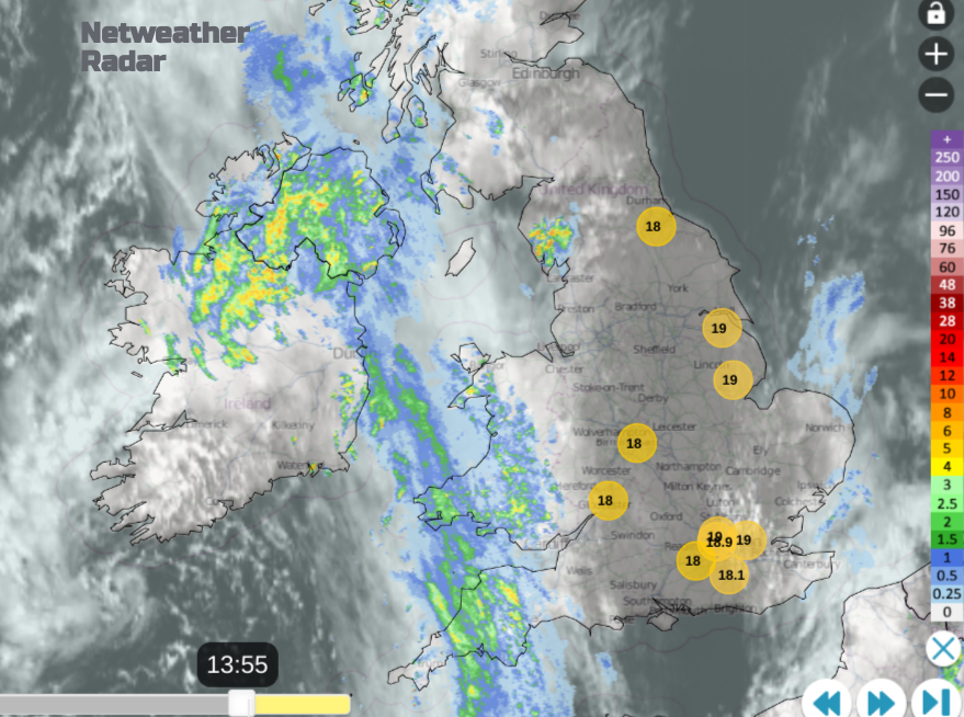
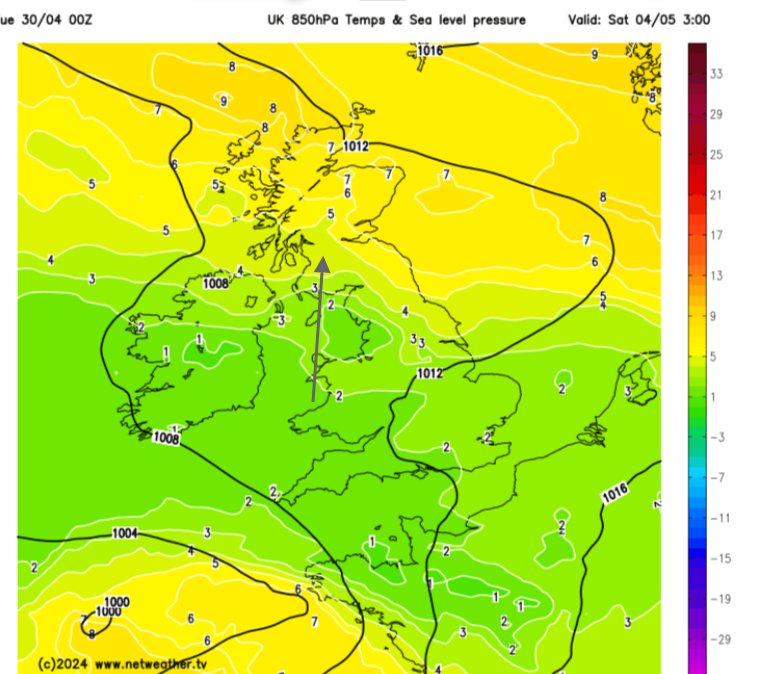
A low pressure over Ireland on Tuesday is throwing frontal rain over Northern Ireland and western Britain with more sunshine for central England and NE Scotland in a blustery southerly wind. A developing low pressure over central Europe will change the flow as a warm front reaches over the UK Wednesday into Thursday.
Outbreaks of heavy rain are forecast to move up through the eastern counties of Britain early on Wednesday with more cloud. At times there will be an easterly flow off the cool North Sea with western Britain seeing the highest temperatures. The far NW of Britain could see 19C and SE Britain could reach 21C.
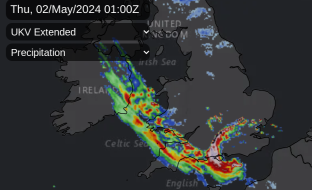
Another pulse of wet weather will appear for central southern England later and head to Wales and the West Country by Wednesday evening followed by potentially thundery bursts from the Channel. This development is being watched with interest and should head west/northwest during Wednesday night but still linking back from Wales to the Thames by Thursday night
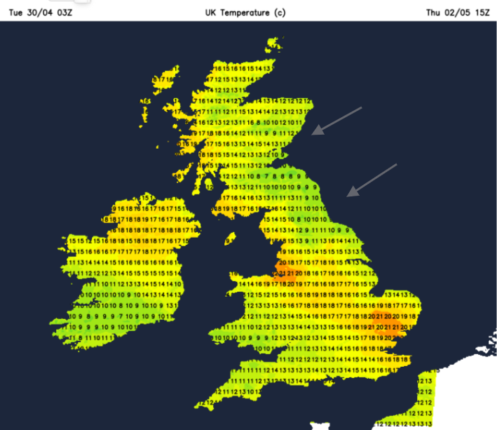
Northeastern England and SE Scotland will feel cool on Thursday in the wind. Further west could see 17 to 20C. The European low will slide over to the UK as the frontal cloud and patchy rain edge northwards.
This introduces a southerly flow once more with sunshine, but that’s not reliable. The cold front from the European low will sweep westwards over the North Sea by Friday, with more cloud and showery rain. In between will be sunny spells and the chance of 17 to 22C.
The forecast at the weekend becomes more complex. The warmer air from the week will edge northwards, and we could see some fresher air drawn in, allowing a coolness by night. The ECM model shows showery outbreaks by Sunday afternoon, which push northwards during Monday. So a mixed picture with bright spells and scattered showers, although there is a chance that high pressure centred over the Baltic subdues our Bank Holiday weather, which could result in something more settled.
We are not mentioning heatwaves. The top temperature looks to be around 21 or 22C, so 72F for a few parts of the UK in any sunshine. It’s still a mixed picture. You could be lucky this weekend and see fine weather. However, there is still uncertainty about the details of any patchy rain at the weekend, so we will need to wait a day or so to see the models settle.
If you have an event this weekend, don’t be despondent if there is a rain symbol showing for the important three-hour slot, we need to wait for that kind of detail. If you are packing to go away in the UK, don’t be too influenced by “warming up” headlines. Thicker cloud, the breeze, any rain and after dark will still make it feel cool, we’re not into sultry summer yet. You could be lucky with pleasant sunshine and a warm half day but it’s unlikely to last. Tree pollen levels are rising, up to Moderate, even High in places.