


Showers in places today and especially tomorrow, but Tuesday onwards high pressure will build across the UK, bringing increasingly drier, sunnier and warmer conditions, though Scotland will turn cloudier with some rain from mid-week. Temperatures reaching 20-23C later in the week
It was not too bad for day one of the Bank Holiday Weekend across southern areas of Britain with some sunshine, a cloudier Saturday across northern areas and it was some 8-9C cooler across parts of Scotland than Friday, when it reached 20-23C in the sunny Highlands. Sunday will be generally cloudy again across the north with some showers, locally heavy, across the northeast and also cloud and showers moving in across the far south, sunshine in between. Bank Holiday Monday will likely be the most unsettled day – with thundery showers breaking out quite widely across England, Wales and southern Scotland.
High pressure looks set to build across the UK this coming week, though Atlantic fronts will plague the far north
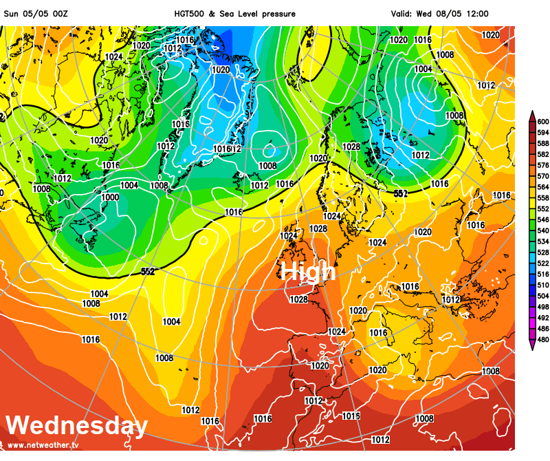
However, as we go back to work and school next week, it’s looking like an increasingly settled picture, as high pressure builds in through the rest of the week. Still a risk of some showers as cloud builds on Tuesday, but less heavy and some warm sunshine around too. Wednesday onwards it’s looking mostly fine and dry with some warm sunshine for England and Wales - as high pressure builds in across the UK. Scotland will be cloudier at times though, as Atlantic fronts graze here, along with some outbreaks of rain, more particularly north of the central belt, wettest in the northwest.
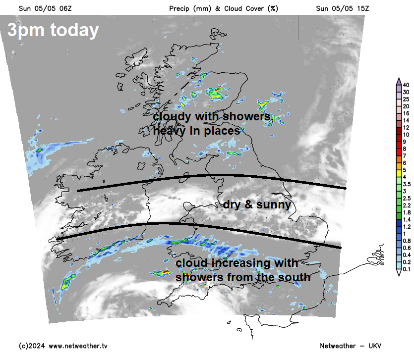
Back to today, Sunday is off to a promising start with blue skies across Wales, Midlands SE England and East Anglia. However, it’s a cloudy morning across Scotland, N. Ireland, much of northern England and SW England. The warm sunshine between the north and southwest cloud will be increasingly squeezed out through the day, as cloudier skies and some showers spread north across southern areas into the afternoon, while cloudy skies with some showers linger across the north throughout the day, some the showers turning heavy across Scotland, with the odd rumble of thunder. Temperatures reaching 17-19C across central and eastern areas of England – where we keep sunshine for longest, still 15-16C in the cloudier areas.
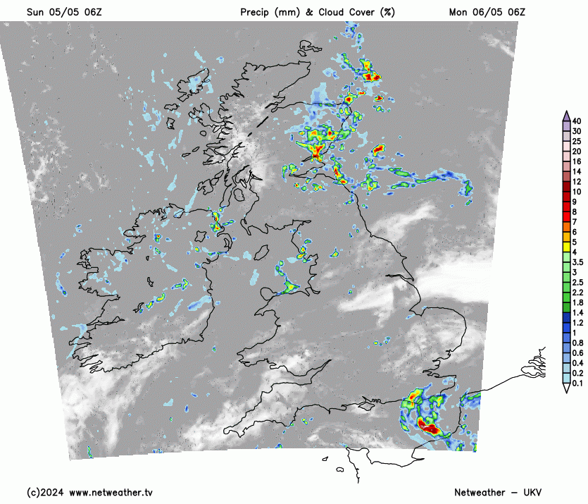
It will stay quite cloudy across the north tonight, with further showers in the northeast. Cloudy across southern England, with some showery rain moving in across the southeast. Dry with clear spells across central areas.
An area of low pressure over the English Channel and northern France on Monday will bring a threat of showery rain from the word go across SE England, while after a bright start elsewhere across England and Wales, scattered showers will also develop, which will turn heavy with a risk of hail and thunder. Some sunny spells between showers. After a cloudy start across Scotland and N. Ireland, some sunny spells developing, but also some showers developing in places, again, locally heavy with thunder. Temperatures reaching 15-17C generally, cooler across the far north.
A quieter day on Tuesday, as high pressure starts to build in. There will be sunny spells and variable amounts of cloud, which will tend to be shallow convective cloud that will tend to fill the sky and will produce some showers across more northern and western areas, though generally lighter than Monday. Best of the sunshine across eastern areas. Where the sun comes out, pleasantly warm, with temperatures reaching 16-19C, perhaps 20C in a few spots.
High pressure become more established on Wednesday, so most places should stay dry, not wall-to-wall sunshine though, although there will be sunny spells for many, cloud will bubble up and fill the skies in places, perhaps thick enough for the odd light shower, but most places dry. Temperatures reaching 17-20C widely.
England and Wales mostly dry and sunny on Thursday, temperatures reaching 18-23C. But with high pressure slipping further south, Atlantic fronts look to make inroads across Scotland and N. Ireland from the west, bringing a cloudier day, with outbreaks of rain mostly north of the central belt, but still warm reaching 17C.
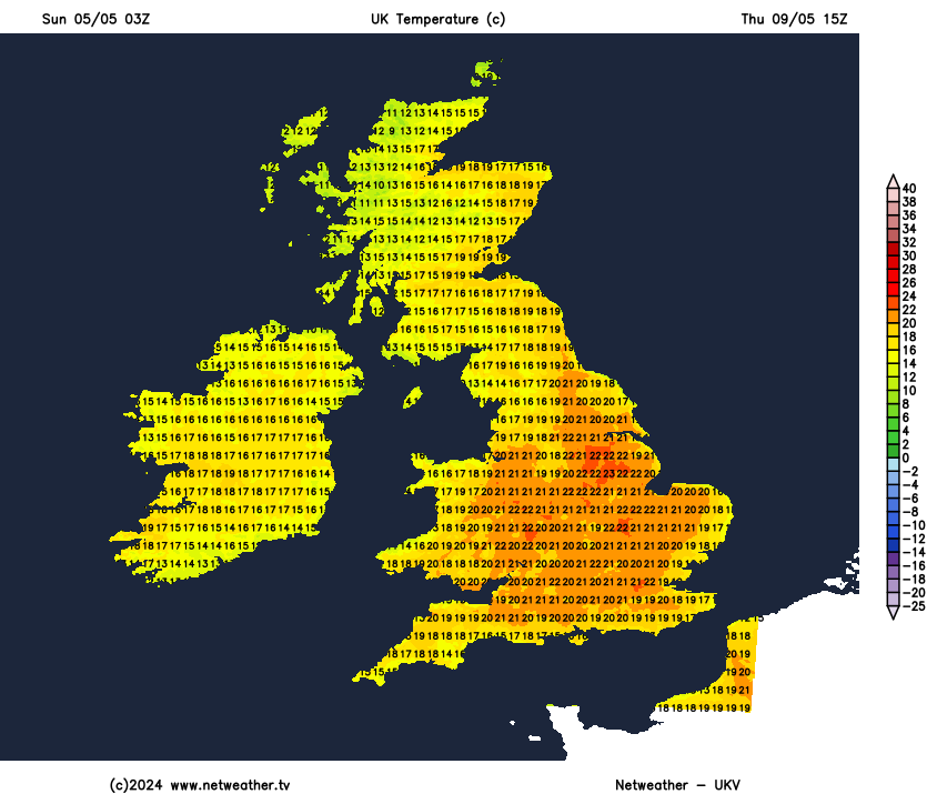
High pressure looks to build back north on Friday, ensuring a mostly fine, warm and dry day, but it may not be wall-to-wall sunshine for many, with cloud tending to build in filling the skies, which could produce the odd shower. Temperatures reaching 18-23C in the sunshine.
High pressure looks to hang on next weekend across the east, bringing more warm sunshine and mostly dry conditions for many, but perhaps an increasing risk of thundery showers across the southwest and far west by the end of weekend.


