
Temperatures are rising, and with plenty of sunshine on Saturday, we should see 18 to 26 Celsius. A showery breakdown changes things for the start of the new week, but Sunday could still be very warm.
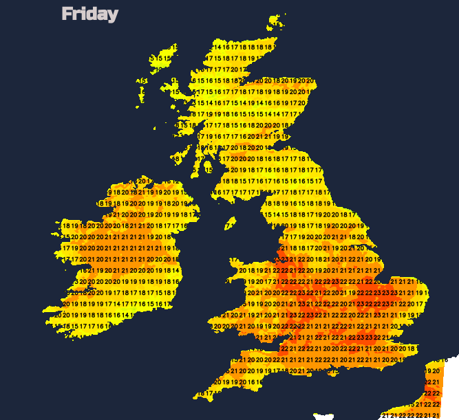
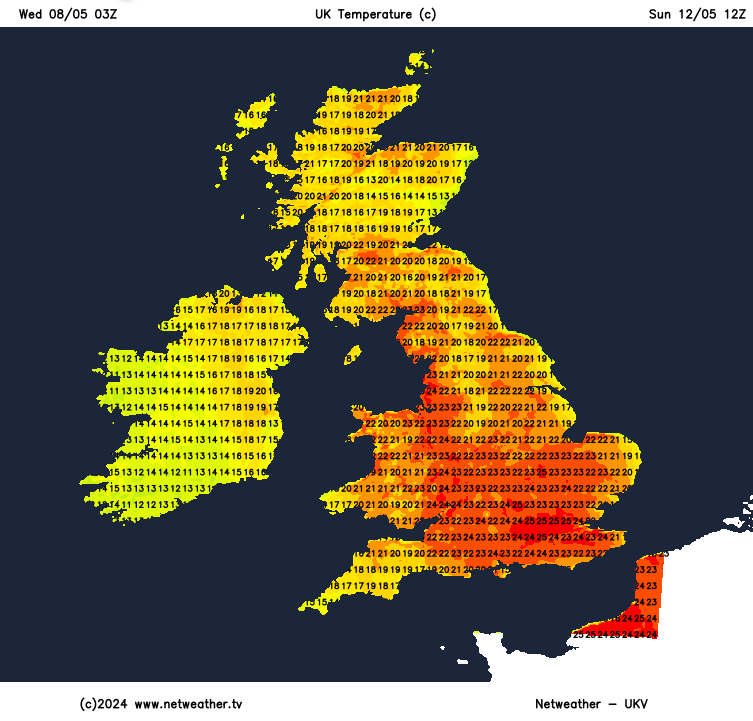
This weekend looks warm, even very warm with the top temperatures ranging from 17C to 25 perhaps 26C. A lot will depend on the cloud cover. In the bright sunshine, daytime maximums will pop up. London could see 26C on Sunday which will feel very warm. Bristol, Manchester and Glasgow up to 23C and Ipswich 21C this weekend. Under stubborn cloud, the temperatures will be subdued but there will be much less of that by Saturday.
The highest temperature we’ve seen so far this year was 23.4C in Suffolk on the 2nd May. Derbyshire reached 21.2C on the 6th, the early May Bank Holiday Monday. The May monthly temperature record is a long-standing 32.8C with the late May Bank Holiday weekend more likely to see higher temperatures, climatically speaking. That’s not a forecast.
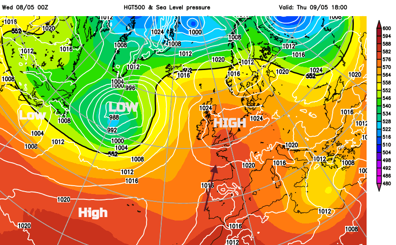
High pressure over the UK this week is forcing weather fronts northwards. Winds have been light and the weather has been settled thanks to the high but the fronts will continue to bring rain with blustery winds to the northwest of Scotland. Friday looks drier everywhere.
Across the UK, it is the cloud cover which will restrict our top temperatures midweek but by Saturday there could be more sunshine allowing temperatures to reach the mid-twenties. There is uncertainty about Sunday; how much cloud there will be and developments from the west leading to showers.
This warmer air is being drawn up from North Africa through Iberia and France. Madrid could see 28C this weekend as Barcelona stays closer to 23C and Nice and Paris 21C. The high pressure will drift towards Denmark by Friday night. Low pressures begin to gather, from the west and the south which means that our UK weather will change either later on Sunday or by Monday. Heavy showers, even thunderstorms followed by more widespread rain ready to impact the UK for the start of the new week. Before they take hold, the warmth will continue, although there will be more cloud as the weather turns unsettled.
As high pressure builds over the more traditional spots of the Azores and Scandinavia, the warmer air fades slightly as it shifts eastwards. Southern Scandinavia will see temperatures lifting into the high teens next week, which is a change from their coolness this week. For the UK, we see more of an Atlantic influence with cooler, more unsettled weather. The airflow will be from the northern Atlantic as low pressure settles over the UK on Tuesday. So we could be pleased that the warmth and sunshine are timed for the weekend.
No. It’s just a warm few days, in May. Strictly speaking, you could qualify as a heatwave at a specific location if it reaches 25C for three days in a row for parts of the UK. This time the areas most likely to see 25C have a higher heatwave threshold, of 28C. “Heatwaves are extreme weather events” Met Office.
It is a shame that some in the media have to scream Heatwave this weekend each time UK temperatures rise. Heatwaves impact people’s lives and when there needs to be official warnings about an upcoming heatwave, all this hyperbole does is dilute that important message.
“Heatwaves amplify the impact of drought, increase wildfire behaviour, hazardous smoke, water insecurity, power shortages and agricultural losses, which causes significant damage to communities around the world”. WMO
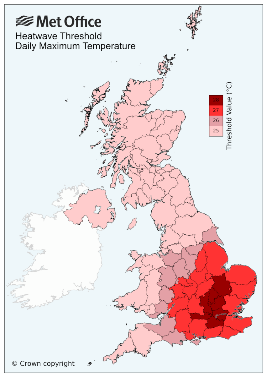
"A UK heatwave threshold is met when a location records a period of at least three consecutive days with daily maximum temperatures meeting or exceeding the heatwave temperature threshold. "MO
Temperatures should widely reach 17 to 22C inland on a fine, bright day. The winds will be light and dry with just a small chance of a shower for inland northern England and towards the Humber. Northern Ireland and Scotland will be sunny so a better day here with temperatures reaching 22C in a few spots.
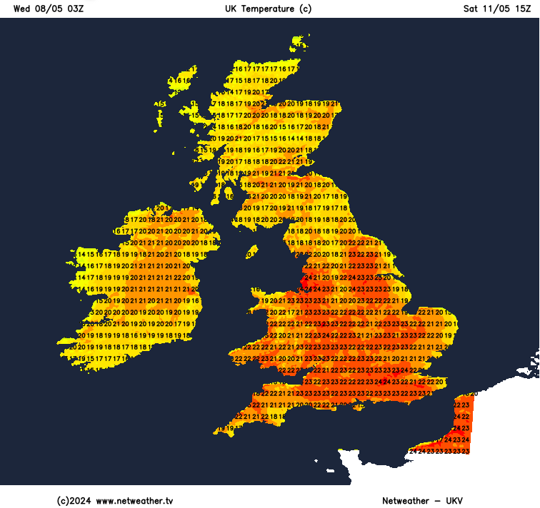
Overall it will be a dry, warm day with a lot of sunshine. There will be some infill of fair weather Cumulus cloud with a few showers over the high ground of northern England into the Scottish Borders. Many areas will see 18C to 22C with 24 to 26C possible.
The day will be a balance, starting with the ongoing settled dry, bright and sunny weather but tipping towards an unstable, showery picture with more cloud and a southeasterly flow off the North Sea. After a sunny, warm Saturday, Scarborough and Whitby could struggle a bit on Sunday, only reaching 14C. For Northeastern Britain there will be pockets of low cloud, seafret or haar but with sunny spells inbetween.
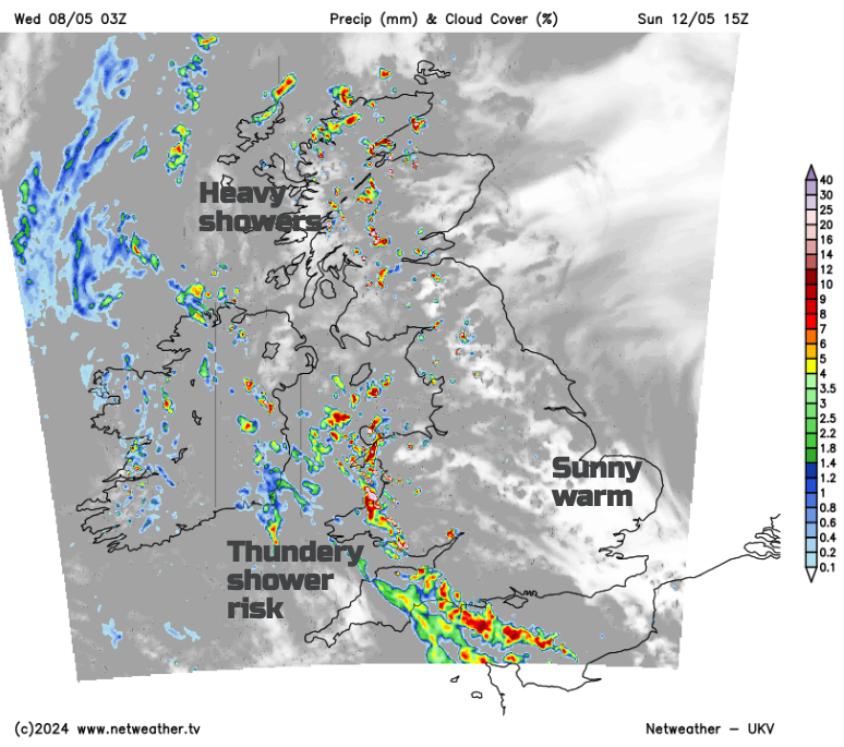
The sunshine in the south will turn more hazy as high cloud filters up from France, Brighton should feel pleasant at 21C. There is the potential for many areas to see a warm day with 17 to 26C. The uncertainty comes from the change, the tip to the heavy showers. There will be the risk of heavy downpours even thunderstorms which looks higher for SW England and SW/W Wales by the end of the weekend. Inland Scotland will see showers, with the southeasterly flow off the North Sea managing to subdue the activity over eastern Britain. Don’t write off Sunday because of this shower risk. There will be more fine, warm weather, particularly for central and eastern Britain but it will be worth watching developments on the radar on the day. The risk of rain or a hefty downpour increases on Monday.


