


Setting off Friday or Saturday for the festive season? What does the weather have to add to your travel plans.

Many schools will have broken up for Christmas by the end of this week, some folks from work too. So the Christmas get away will begin Friday and Saturday as people head off by road, train, ferry and air.
Firstly, it is not going to be as mild. Cold air will spill down the UK during Friday, so Friday night will be colder, ice and air frost for Scotland and touches of frost for inland Britain. Wintry showers reappear for Scotland and the higher ground of northern England, and Snowdonia. Saturday night looks cold for inland England with a risk of frost for SE Britain.
There will be a lot of fair weather around this weekend for southern Britain.
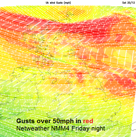
Friday looks windy with strong winds for Scotland, gusts over 60mph into the Irish Sea, The winds peak overnight with severe gales for NW Scotland and strong, gusty winds for the northern half of the UK. Easing slowly Saturday then windy again on Sunday but not as strong
ROADS
There are low level yellow flood alerts out from the Environment agency for parts of Wales and England. Heavy rain this week is causing river and surface water flood and into the weekend, a low river flood risk in parts of Shropshire and Telford and Wrekin along the River Severn. These areas do dry up at the weekend. Scottish Bridges – windy Friday evening and overnight into Saturday. Strong and gusty winds for higher level routes over the Pennines and across Scotland Friday evening and night. Risk of ice on northern roads, wintry showers with hail, sleet and snow. Blizzards conditions on high routes like the A9 Friday night. Sunny on Saturday watch out for the low sun, might need shades whilst driving for those few daylight hours.
FERRIES
Scotland and Irish Sea: Strong winds with W. gales Friday. Early Friday severe gales for Northern Isles, easing then winds strengthening across northern UK for Friday evening, risk of severe gales for W.Scotland. North Sea-: Saturday morning, very windy with W. gales, sailings from NE England. English Channel: gales around Kent very early on Friday will ease then just blustery
TRAINS
Heavy rain for Wales and W.Scotland into Friday with more rain forecast for W.Scotland on Sunday
AIR
Lee waves have been causing some concerns for aviation forecasts around London this week. Fog can impact airports, especially for London with knock on effects around the UK. Overnight Saturday does look cold in the SE with lighter winds, but hopefully there will still be enough breeze to keep the air moving, and so clear for early Sunday flights
SLEIGH
For the important journey from the North Pole, there could be a tail wind speeding Santa’s sleigh towards the UK. Be good!


