Latest synoptic outlook, looking at the likely weather patterns affecting the UK and Europe over the coming 14 days. A blocked pattern continues across much of northern Europe.

Last time I did an update around this time last week, I talked about the stalemate between Atlantic upper trough trying to advance east against stubborn block over eastern Europe and W Russia continuing right until the end of the month. Well this still holds true for this last week of November.
Looking at the upper pattern across the northern hemisphere, two large upper vortices at 500mb (two split lobes of the polar vortex) continue to dominate the high latitudes over the coming days, one cold vortex spanning northern Canada and Greenland, the other extending across Siberia. In between, a blocking high continues to dominate western Russia and NE Europe. A strong westerly jet at the base of the cold vortex over Canada spreads out across the N Atlantic, but its progress east is impeded by the block to the east of the UK, causing the jet to bifurcate (split) to the west of the UK, with most energy being set SE towards SW Europe initially this week/weekend before most energy goes into a northern arm way to the north, this allows mid-latitude high pressure belt to become a dominant feature of the UK this weekend and through next week, despite of a temporary attempt of a breakdown form the NW on Monday.
The cold vortex over northern Canada and Greenland is not static rather is ‘wobbling’ around, with pulses of cold upper air fragmenting off it creating waves in the jet stream. One of these waves of cold air is pushing east across the USA over the next few days and it will be responsible for deepening a low tracking NE along the eastern seaboard, the resultant deep low by Thursday, named ‘Cato’, is expected to bring a winter storm for Thanksgiving, perhaps dumping up to a foot of snow across the mid-Atlantic states, maybe more over New England.
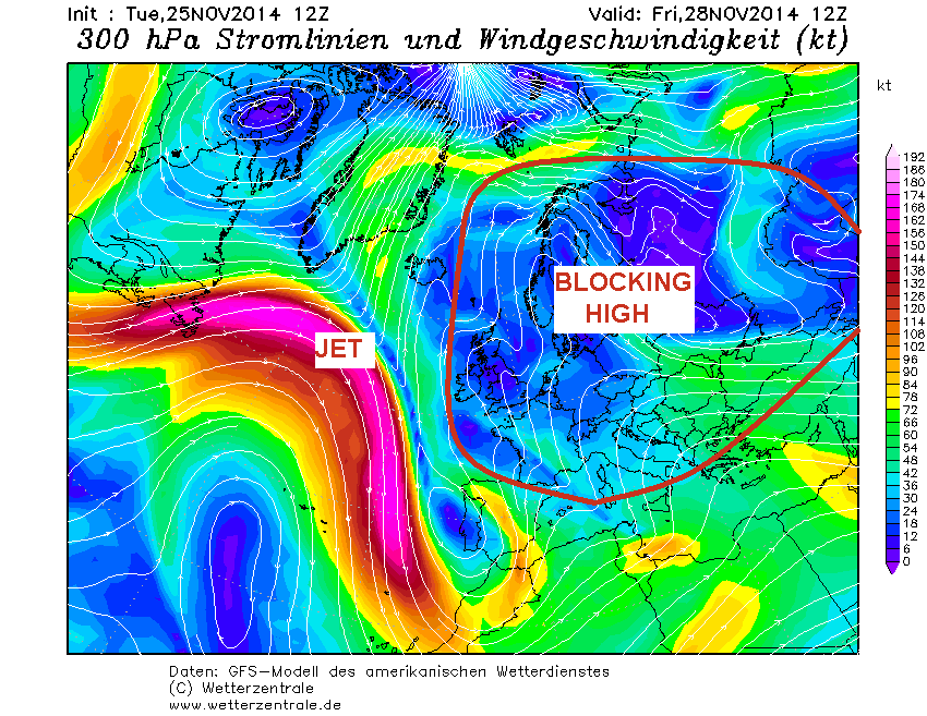
Meanwhile, downstream of this wave a strong jet stream spreads east across the north Atlantic then crashing against the persistent blocking area of high pressure over eastern Europe (above), which forces the jet to dive SE towards Iberia, resulting in another wave amplifying into a deep trough that extends SE into Iberia and Morocco by the end of the week. Eventually, the jet buckles and weakens which causes the upper trough to disrupt into a ‘cut-off’ upper low over SW Europe and far NW Africa on Saturday before the low drifts into the central Mediterranean region on Sunday, this allows a ridge from the Azores high pressure system to extend NE across the UK and link with the high pressure system over eastern Europe. The flow will be rather slack across the UK over the next few days, but a stronger southeasterly flow will develop by the end of the week, as low pressure deepens to the SW of the UK in response to wave amplifying into SE into SW Europe. The rain today and tomorrow will be replaced by drier and brighter conditions Thursday, but rather cloudy conditions as we head into the weekend as the southeasterly turns easterly. But temperatures will recover later this week and quite mild in the south despite the wind direction, and continuing mild over the weekend.
Early next week (start of December) something more seasonal, today’s operational runs of GFS, UKMO and ECMWF erode this belt of high pressure across the UK from the northwest, as fragment of colder air breaks SE from the vortex over Greenland. This allows the westerly jet to sink SE across the UK, introducing colder air from the northwest across the UK on Monday into early Tuesday. Then most models agree on high pressure building back in from the west by mid-week next week. And with the colder airmass that arrived on Monday from the NW still hanging around, the anticyclonic conditions are likely to bring a chilly feel - with a risk of widespread overnight frost and freezing fog forming. 12z GFS and ECM operationals and ensembles this evening point towards this anticyclone hanging around until the end of the next week (day 10).
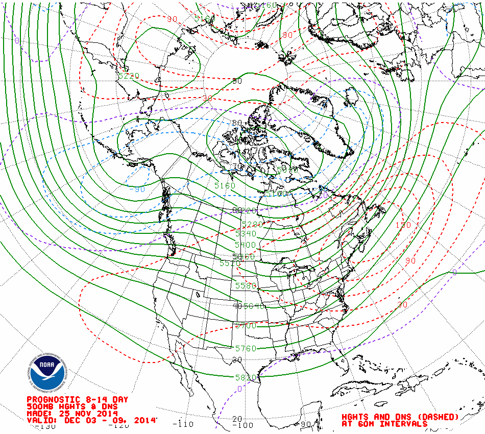
Days 11-14, it is unclear whether the anticyclone will hold sway over the UK, or whether low heights/troughing will push in from the NW displacing the high. 12z GFS ensemble mean and CPC prognostic 8-14 day 500mb HGT chart (below) suggests the anticyclone perhaps retreating back to eastern Europe while lower heights/pressure edge in from the NW, but, from recent/current backtracks of models from being too progressive in re-introducing a more mobile cyclonic flow from the W and NW – I think the UK could still hold on to anticyclonic conditions away from the NW where it may turn unsettled at times. Temperatures in this period a little below normal, with overnight frosts and chilly by day with temperatures slow to recover.