
Latest Synoptic Outlook, looking at the weather patterns affecting the UK and Europe over the next 14 days. Much of Europe remaining mild and unsettled towards the west.
Last week I discussed the effects ex-Hurricane Nuri approaching the Aleutian Islands off Alaska as a powerful extra-tropical storm, which amplified the trough extending from eastern Siberia into the N Pacific, which in turn, forced strong warm air advection aloft building an amplified ridge ahead of it north across Alaska and towards the North Pole. The subsequent high latitude block across Alaska and towards the Pole will be observed through the rest of the week, though are signs on morning output that the ridge will break down early next week now. The amplified upper wave which pushed north across Alaska towards the north Pole has pushed cold air south across N America and a lobe of the polar vortex will push south into Canada/E USA by early next week, with deep cold trough reloading south over the next 10 days.

Downstream across the N Atlantic/Europe, a broad belt of low heights currently extending SE across the Atlantic towards W Europe, will form a closed upper low just west of the British Isles later this week. A slow-moving low pressure system maintained just to the west of the UK for much of the week, progression east stopped by high pressure block to the east. Slow-moving frontal systems will affect the UK on Tuesday and again later in the week, bringing rainfall totals above average in some spots with risk of flooding, particularly in the west.
The ridge to the east is then indicated by GFS, ECM, UKMO and GEM to extend further NW across Scandi and then towards Iceland/eastern Greenland by the weekend while Atlantic troughing finally pushes further east beneath the high latitude block. This will mean an easterly flow develops across the UK during the weekend, continuing into early next week, as low pressure systems start to track east to the south of the UK. The easterly flow will be relatively mild though, with no cold air at source. There is some divergence between the models days 7-10, with regards to potential trough disruption over western Europe as ridge builds north over the mid-Atlantic in response to lobe of PV digging in across eastern N America and the ridge building NW from Europe. The potential trough disruption looking quite messy, so hard to go into too much detail over exact synoptic evolution over western Europe and the UK.
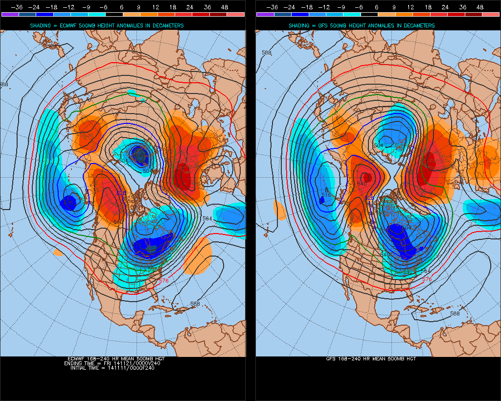
By day 10 (Friday 21st) – 00z ECM and GFS ops and 00z EPS + GEFS mean broadly agree on the lobe of the polar vortex over eastern N America (cold 500mb vortex) shifting further E and spilling across Greenland and far NW Atlantic and strengthening over eastern Canada and Labrador Sea. Upper trough extending SE from the vortex across the Atlantic towards Azores, ECM and GFS operational showing a cut-off low having developed over the Canary Islands by then from previous trough disruption over NE Altantic. 00z GFS op shows downstream a strong amplified ridge NW across the UK towards Iceland and Greenland, weaker but similarly aligned ridge from ECM, EPS and GEFS.
8-10day ECM v GFS 500mb height comparison:

Days 10-14, reverting to model data available after day 10, flow still looks to remain high meridional across N America, N Atlantic and Europe. 00z GFS op has W Europe under a ridge in the upper waves so looks highly anticyclonic over the UK. However, the GFS parallel has a long-wave trough shifting east across the UK, bringing Atlantic depressions and a cyclonic southwesterly flow. GEFS mean similar to parallel run. So, there may finally be a shift east in long wave pattern, with the deep cold over E Canada forcing a long wave trough to progress east towards the UK bringing an eventual return to more cyclonic and unsettled southwesterly winds by day 14. Though there is potential that blocking over northern Europe may delay or prevent advance of the long-wave trough from the west. But either way, it is likely to remain relatively mild.
Beyond 14 days, the polar vortex may remain under stress, helped by 1 or 2 Rossby waves pumping warm air poleward from the troposphere towards the stratosphere. This is backed by longer range ECM ens mean 10mb temp anomaly charts yesterday, which suggested a stratospheric warming over Eurasia mid/late November, which will put further pressure on displacing the polar vortex with an increased risk of deep cold reaching the UK late November or more likely early December. Though it must be stressed that a stratospheric warming is no guarantee for cold and wintry weather for the UK, it just increased the likelihood. Furthermore, November has started with a significantly –ve (easterly) QBO which is reversing the mean zonal winds into the stratosphere and thus putting further pressure on the Polar Vortex. Also, the high Eurasian snow cover advance recently may also have an effect on vertical propagation of the Rossby wave into the stratosphere and helping put yet further pressure on the polar vortex. OPI winter forecast further hints at a negative Arctic Oscillation (AO) signal this winter, meaning northern Europe may see a greater risk of cold and wintry weather in the weeks ahead than the run up to Christmas last year.


