
Latest synoptic outlook for the UK, covering the next 14 days. Chilly for a few days, then turning milder and unsettled end of week into weekend. Staying unsettled next week with temps close to or above average, perhaps becoming settled in the north and east later in week.
General synopsis for next 14 days.
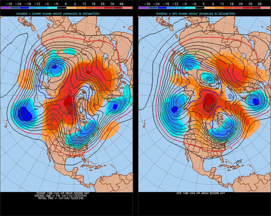
Weather models are forecasting a substantial rise in 500mb geopotential heights/blocking across north polar region by the weekend, due to strong poleward warm air advection across Alaska ahead of deepening eastern Siberian/Kamchatka upper trough and very powerful ex-tropical storm Nuri heading towards Bearing Sea/Aleutian Islands over the weekend. As a result of the polar block, the Arctic Oscillation (AO) will drop sharply into negative territory, with a corresponding shift south of the polar front jet stream across the north Atlantic over the 5-7 days, which in turn will signal an increasingly negative North Atlantic Oscillation (NAO). Models suggest deep long-wave upper trough will prevail across western Europe for at least the next 8 days, amplifying south into Morocco and Algeria, the progress east of the long-wave stopped by a blocking ridge across eastern Europe and western Russia. Upstream, a deep cold vortex will push south across Canada in response to rising heights over polar region, the cold vortex becoming stuck across eastern Canada and bringing cold conditions to eastern N America. So the upper wave pattern will become rather stagnant and meridional across much of N Atlantic/Europe into the medium range. The weather across the UK and Ireland is likely to be dictated by the presence of upper trough over next 8 days at least, with unsettled conditions prevailing though temperatures are likely to become close to normal or slightly above after a cooler period this week, given UK will be on eastern side of the upper trough with surface flow likely to drawn from a mild near continent.

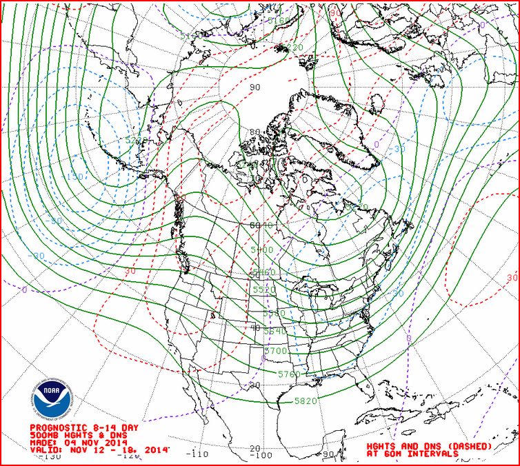
ECM EPS ensemble mean and GFS ensemble mean at day 10 (t+240) indicate block holding to the east with upper trough across western Europe disrupting into a cut-off upper low while height rises occur far north Atlantic and Iceland region ahead of cold vortex across NE Canada. Days 10-14, a wide range of solutions from GFS ensembles, some going for low heights/upper vortex to organise across Greenland/Iceland area, which would re-introduce an unsettled westerly or southwesterly type across the UK, other members continue with a more blocked theme, with an elongated, negatively-tilted trough extending SE across western and southern Europe – the latter scenario favoured by today’s CPC prognostic 8-14 day 500mb heights (below):
Short-term highlights (next 5 days)
Low pressure system over the N Sea tonight will bring a chilly and showery northerly flow across the UK, transient ridge of high pressure will build from the west of Wednesday, with showers becoming confined to eastern England. A cold Wednesday night/Thursday morning, with widespread air frost in rural areas. After a daytime in the east Thursday, cloud, rain and strengthening southerly wind in the west by lunch spreads east to all parts by late evening. Rain, locally heavy, slowly clears east on Friday, followed by clearer showery conditions across the west. Temperatures recovering as milder air moves in.
Low pressure centred close to the NW over the weekend, bringing a band of rain or showers eastwards both days, southwesterly wind will mean temperatures will be slightly above average.
Longer-term highlights (6-14 days)
Some uncertainty over the surface pressure patterns early next week, though pressure is likely to be lowest towards the west or southwest, with the UK under a Sly or SWly flow. The flow will be cyclonic with weather fronts likely to bringing further areas of rain or showers affecting many areas, with temperatures average or slightly above average. From mid-week, we are likely to see low pressure system to the west move SE into the Bay of Biscay and either N Spain or W France, as increasingly deep upper trough and jet stream carve southward across western Europe. As the trough become increasingly negatively-tilted (NW-SE aligned), further lows look to move NW to SE into Bay of Biscay and eventually western Med. This will mean winds from the SE or E, bringing in mild air from a mild near continent fr southern Britain. Further spells of rain and perhaps strong E/SEly winds for southern and western areas. But northern and eastern areas becoming drier as pressure rises from the E, with a risk of frosts overnight, and perhaps the temps here generally falling slightly below aeverage overall.
Further update later this week ...


