


Latest forecast discussion for the uk, covering the next 14 days - including a look at the impacts of Hurricane Gonzalo on the UK weather early next week.

*UPDATE 2200z Saturday 18th October*
Hurricane Gonzalo continues to move rapidly northeast tonight at around 31knts as it becomes embedded in the strong southwestelry flow on the eastern side of upper trough across NE USA. Over the next 12 hrs Gonzalo makes the transition to strong extra-tropical depression, as it moves over sub 20C SSTs and encounters increasingly strong southwesterly vertical wind shear. This extratropical depression is expected to be just east of New Foundland at noon on Sunday, at around 977mb. The depression then turns east-northeastward over the far north Atlantic, pushed along by a strong westerly polar front jet stream towards the British Isles, filling as it does so.
GFS and, to lesser extent, ECMWF, then suggest the depression then deepening again and tracking more NE in direction during Monday, as a sharpening shortwave trough digs SE from southern Greenland towards the low, causing it to deepen as large scale ascent occurs ahead of the trough. The low also falls increasingly under the developmental left exit of the strong Atlantic jet on GFS, which further helps to deepen it. So there is some concern that this low could have some severe impacts on the UK, as it moves NE close to or over Scotland early Tuesday morning, the exact track and depth still uncertain at the moment. GFS indicates winds will be strongest when they turn northwesterly on the southwest flank of the low moving northeast, strongest winds across the northwest Tuesday afternoon, with northwesterly gusts of 60-70mph before gusts of 50-60mph spread SE across Scotland, N. England Tuesday evening/night then E Anglia and into the North Sea Wednesday morning. Heaviest and most persistent rain likely Tuesday morning, followed by frequent showers across the north and west as winds turn northwesterly.
A brief ridge builds across the south on Wednesday, bringing fine weather here, remaining more unsettled and windy in the north. But pressure/heights fall again from the NW Thursday and Friday, bringing more in the way of cloud and some rain to end the week and into Saturday 25th. Still enough continuity from GFS and ECMWF to have some confidence thereafter for a strong ridge to build from the SW starting Sunday 26th, in response to an amplified trough coming out of NE USA/ E Canada that digs deep across the NW Atlantic. Although exact position of the ridge far from being resolved this far off, increasing chance last week of October could end on a more settled and dry note, following the current unsettled spell.
.... PREVIOUS DISCUSSION from Friday 17th October ...
General synopsis over next 14 days
An amplified upper long-wave trough lies N-S across the NE Atlantic with a deep depression mid-N Atlantic moving NE and slowly filling over next few days. A strong S or SWly warm air advection (WAA) regime across western Europe including the UK today and over the weekend ahead of the low will bring above average temperatures. A blocking high over western Mediterranean/N Africa will cause the trough to disrupt into a cut-off upper low by Monday - which will centre between the Azores and Canary Islands. Upper westerly flow will then take over across NW Europe/UK early next week, the strong westerly jet will pick up Hurricane Gonzalo, turning it ex-tropical as it encounters the polar front before bringing it as an ex-tropical low towards/across Ireland and the UK later on Monday and through Tuesday. A cooler northwesterly flow follows the clearance of this depression for a time, as the low tracks east towards Denmark, before the flow turns to a milder westerly or southwesterly for the rest of the week, to the south of low pressure systems centred to the north and northwest of the UK.
Longer term, in the 8-14 day range (next weekend of 25th/26th into last week of October) current indications are that the flow will buckle again upstream with a deep upper trough amplifying south across the NW Atlantic while a ridge of high pressure builds north, in response, across western Europe, including the UK. The NW Atlantic trough and western Europe ridge perhaps eventually progressing east. This period perhaps seeing a return to or continuation of above average temperatures.
Short Term (5 day outlook)
A deep depression over the north Atlantic, at 965mb and centred around 50'N 24'W at 06z, will move NE over few days, to be centred north of Scotland near the Faroe Islands by 12z Sunday. After a mostly fine and dry day on Friday, bar isolated showers, frontal systems associated with the low to the west will push N and E across the UK and Ireland overnight, bringing outbreaks of rain accompanied by a strong to gale force southerly wind, rain heaviest in the N and W. The rain and local gales clear N and E from most areas Saturday, followed by sunny spells, a strong southerly wind and showers, heavy and thundery in the west. Trailing cold front may drag its heels across SE England on Saturday, keeping it cloudier with outbreaks of showery rain. Southwesterly flow on Sunday will bring showers to northern and western areas, locally heavy and thundery, drier and sunnier across central, southern and eastern areas. A very mild weekend in the southerly brisk breeze with temperatures widely in the mid teens, high teens in the south, locally 20 or 21C in the SE.
Upstream, Hurricane Gonzalo is forecast to track north across Bermuda tonight, bringing a significant threat of costal flooding from associated storm surge along with hurricane force winds reaching 115-120mph. The Hurricane continues northeast towards New Foundland over the weekend, turning ex-tropical as it encounters cooler waters, before crossing New Foundland around noon Sunday, then heading east across the Atlantic towards the UK/Ireland for early next week.
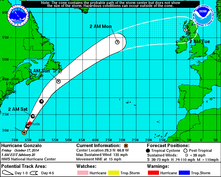
A brisk westerly flow on Monday, most dry and bright in the east, but showers in the west. Then a depression formed from ex-Hurricane Gonzalo is expected to cross the Atlantic on Monday - hitching a ride on the strong westerly jet stream, filling as it does so, so a widening of its tight circulation and turning the low into an open wave on most model guidance, But potential for the wave to undergo deepening into a closed depression. Exact track, depth and timing of arrival of this low in UK waters can't be nailed this far off, though ECMWF, UKMO and GFS take the centre of the low/wave east across Nern EIRE/N Ireland then northern mainland UK before heading into the North Sea. Heavy rain and gales likely to accompany passage of the low Monday night into Tuesday, winds turning strong northwesterly as the low/wave clears, with brighter skies and cooler air following but showers across western areas.
Longer term (6-14 day outlook)
A ridge of high pressure looks to build in on Wednesday from the southwest and hold on across the south for the rest of the week, bringing mostly fine and dry days for southern areas, but with low pressure close to northern UK, cloud and rain at times across the north and northwest as Atlantic fronts move in across here. With the southwesterly flow, temperatures above average Wednesday to Friday next week in the south - reaching mid to high teens. Closer to average in the north.
Next weekend, fairly good confidence for now, for high pressure to build from the S and SW as the upper flow begins to buckle across the Atlantic ahead of upstream trough digging south as it exits east from N America eastern seaboard. So after some rain at first on Saturday, becoming drier across all parts. This blocking ridge of high pressure building north perhaps hanging around well into the last week of October.
I hope to update this blog over the next few days with regards to the track and potential impacts of ex-Hurricane Gonzalo.


