
Latest forecast discussion for the UK, covering the next 14 days. Remaining unsettled, but turning increasingly warm for a time this weekend, especially in the south.
General synopsis for next 14 days
A broad upper trough/cyclonicwesterly or southwesterly flow will cover much of the North Atlantic and western Europe north of 35’N in latitude this week. This trough will amplify mid-Atlantic late this week, while a ridge of high pressure builds N and NE across southern and eventually central Europe this weekend ahead of amplifying upper trough approaching NW Europe, an increasingly warm southwesterly flow, with temperatures rising well above average, will cover the UK ahead of the approaching trough this weekend.
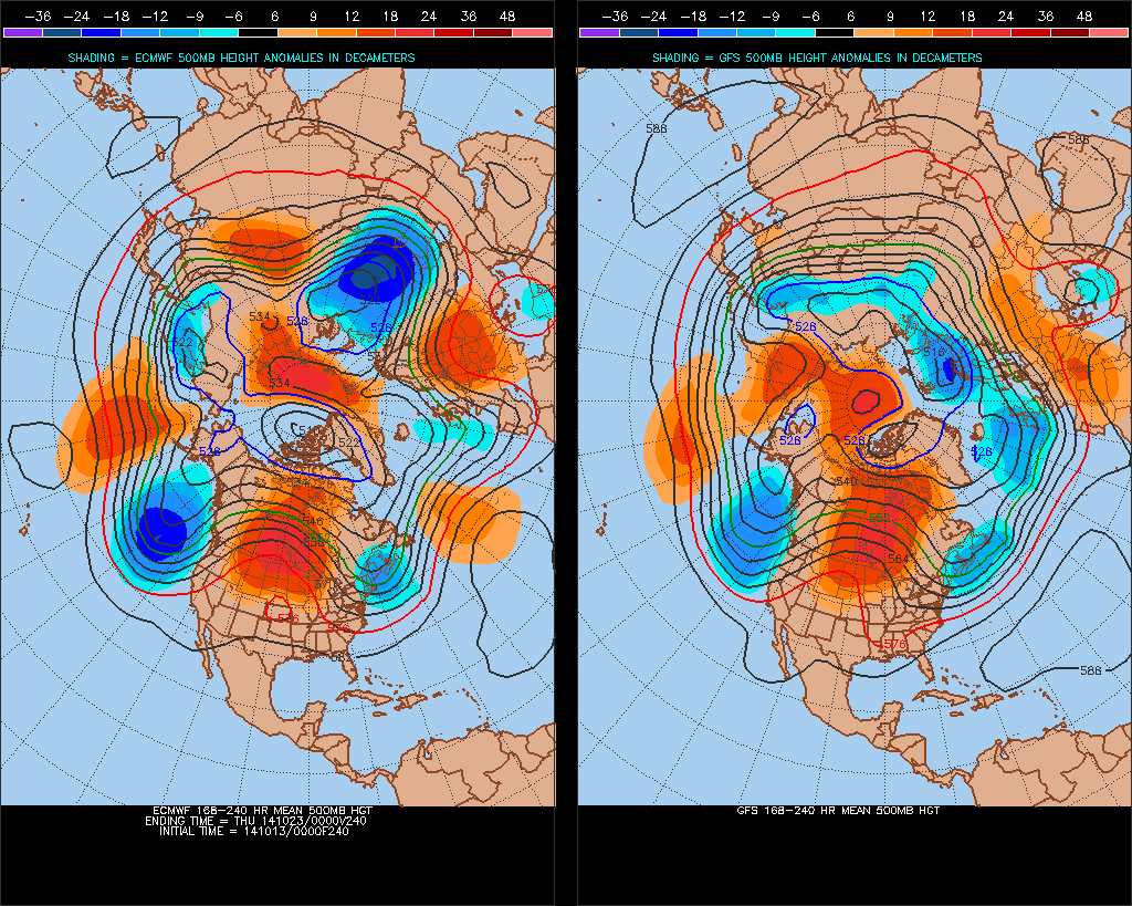
Models then suggest the ridge of high pressure over southern/central Europe then flattening out or sinking SE early next week as Atlantic troughing spreads east across north and west Europe. However, there are difference from the models with medium range output this morning through next week over the depth/amplitude of the troughing spreading east. ECMWF and GEM have a more amplified/slower upper trough spreading east across western Europe, whilst GFS has a flatter more progressive trough
Short term (until the end of this week)
A low pressure system moving east across the NW Atlantic this morning will deepen into an intense but slow-moving depression mid-Atlantic over the next few days before slowly filling to the west of Ireland later this week.
Downstream, a small area of low pressure with a tight circulation will track NNE across SE England and E Anglia today before exiting into the North Sea on Tuesday before merging with general cyclonic southwesterly flow of approaching low pressure system to west of Ireland on Wednesday. Persistent rain, locally heavy, will affect much of southern, central and eastern England along with parts of Wales on Monday and Tuesday before it eventually eases and clears into the North Sea later on Tuesday. Scotland, EIRE and N. Ireland, staying largely dry throughout. Wednesday then looks largely dry across many areas, though rain probably looks to arrive in the afternoon across SW and perhaps central southern England, Wales and Ireland, as an Atlantic front arrives – which will spread showery rain erratically north and east across many areas on Thursday followed by heavy and thundery showers into Friday.
Longer term (this weekend through to Monday 27th October)
Troughing over the Atlantic will deepen in amplitude later this week, allowing pressure/heights to rise downstream across SW Europe/western Mediterranean, though low pressure to the west of Ireland maintaining a cyclonic southwesterly flow across the UK and Ireland. The ridge of high pressure will continue to build north and northeast across southern and central Europe this weekend, ahead of approaching amplified Atlantic trough. UK and Ireland will still be under the influence of the cyclonic southwesterly flow, so expect cloud and rain in the west to then spread eastwards across many areas on Saturday. Cloud and rain perhaps confined to northern and western areas on Sunday, with an unseasonably warm and perhaps sunny southerly flow across southern and eastern areas taking temperatures into the low 20s.

It’s then likely to turn increasingly unsettled again across all areas early next week, as the upper trough to the west makes inroads and areas of low pressure move in from the west or southwest. Some uncertainties of tracks of low pressure, given differences that appear ECMWF v GFS with regards to 500mb flow. But expect spells or rain to spread north and east with sunshine and thundery showers in between. ECMWF and GFS mean 500mb flow charts suggest southwesterly flow to continue to dominate across UK and Ireland for the rest of next week and following week, high pressure perhaps rebuilding over mainland Europe, so southeast England perhaps becoming drier at times, with most of the rain in the north and west, temperatures probably staying close to or above average for the time of year.


