
This evening will seem balmy and warm as thickness values rise to 564. 500-1000hPa charts are quite a simple but effective tool
Wednesday 24th sept 2014
One handy forecasting tool are Thickness charts. The 500-1000hPa thickness charts give indications of temperature changes. Snow lovers watch for the 528 thickness line coming down over the UK on the 500 charts, as a starting point for possibility of some white stuff, but this week it is the 564 line which is giving some interest.
Charts on Thursday evening, tomorrow night, are looking very warm. You should notice the balmy feel to things in eastern England.
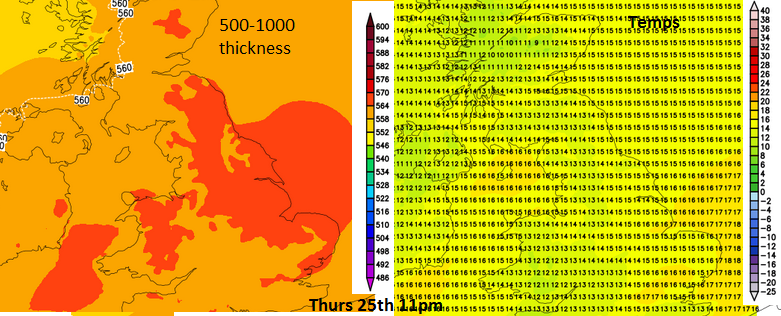
The oranges on the left hand chart show 564+ air and the surface temp chart on the right is still showing temperatures of 16 or 17C for Lincs and the Home Counties, just before midnight. This thickness value is measuring the difference in height between the 500hPa and 1000hPa (surface just about). So cold 528 air is less thick, and the warm, more tropical air of 564 has expanded and is taking up more room, more distance 1000 up to 500hPa. 564 is a depth in dM decametres. Remember lots of things affect the temperature at the surface, winds, cloud cover, warmth in the soil, dampness on the ground etc. Running the sequence of the thickness charts gives an idea of how the air will change over a week, and the 564 signal has been standing out for Thursday for a week now.
By day on Thursday it will also be warm for eastern parts. The brisk SW wind will mean areas sheltered by hills and mountains, like Grampian will be nicely set up for the Foehn effect. Air dries out and warms as it rises over high ground, so tempreatures could be around 22C
There are 850-100hPa thickness charts too, which represent air closer to the surface, so can be used in formula for predicting snow/rain and also used for the maximum daytime temperature.
Thursday- the warm air is arriving over the UK. Last week we saw 26C in the south, but that air had come from the continent, it was dry and there was plenty of sunshine over the UK, with hardly any breeze. The air was stagnant and able to just heat up insitu. Today we have brisk winds, moving the air on and this warm air has come in from the SW, not SE. It is Tropical maritime air, full of moisture and warmth. There is more cloud, but still where the clouds break up in the east and this evening as the winds ease off, you will notice how warm it feels.


