Issued at 1500BST on Tue 20th June based on Tue 20th June 00Z Model Runs
Key Points
Discussion:
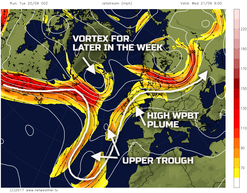
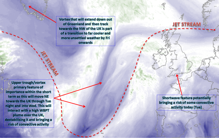
Wed 21st June: Into Wednesday and the overall synoptic pattern has high confidence, with all the main models in agreement for a marked high WBPT plume to be present over the British Isles. It is certainly the fine details that are most uncertain in this kind of synoptic regime. Convective development, in particular on a more local and regional scale is always difficult for models to resolve and tomorrow isn’t any different. However, we start with the broader picture, and that is a particularly noteworthy thermal plume (high WBPT) to be present over the UK, as an upper trough approaches. All forecast models agree on this, and it is this approaching upper trough that will signal the end of the hot and humid of weather of late.
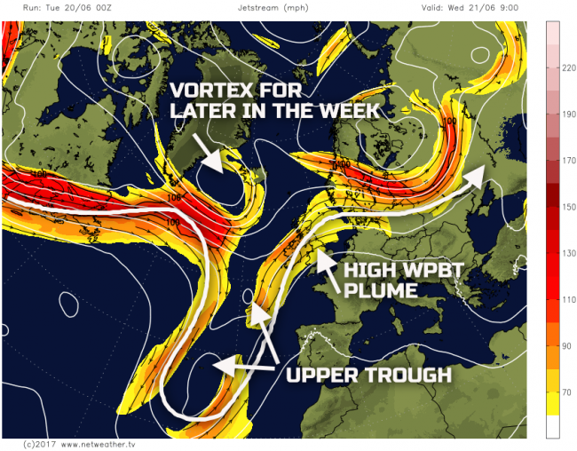
The intricacies of the evolution through Wednesday are pronounced. There are two thermal plumes, of high WBPT. One of which has origins from over France which will extend north across the UK through Tuesday night and into Wednesday. This may potentially bring some convective activity to parts of the N of the UK first thing on Wednesday. The second has origins from parts of the tropics, and it is this WBPT plume which will interact with the approaching upper trough later on Wednesday to, potentially, bring more widespread severe convection later in the day and overnight into Thursday.
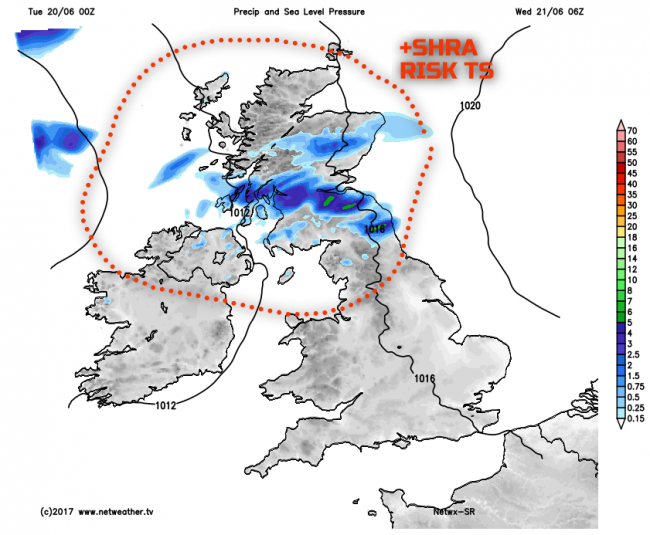
The first WBPT plume, which will be destabilised by filaments of vorticity advecting NE towards the UK tonight, could bring thundery downpours to parts of Scotland, N Ireland and N England tonight and into early Wednesday. Our SR model highlights this risk. While the location of the precipitation is uncertain, it is across parts of the N and W of the UK that some thunderstorms could be in evidence first thing.
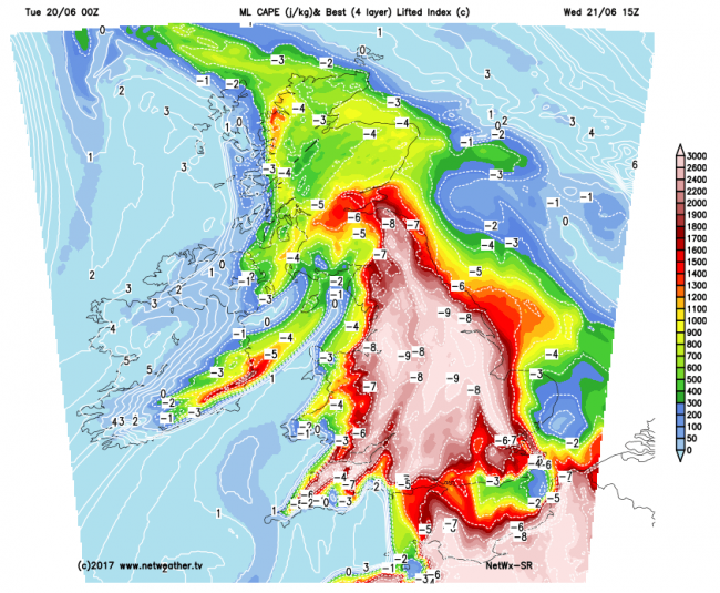
As Wednesday progresses and a combination of forcing, WBPT plume and high surface temperatures and dew points could well lead to a more general destabilisation of the atmosphere. Initially, some thunderstorms could develop from mid-level instability (EML) with altocumulus castellanus in evidence. However, as the day progresses then convection could well become rooted in the boundary layer, leading to an entirely unstable profile. Pinpointing exactly where that will occur, even with HRES model data, is near impossible. It is prudent to highlight the overall risk though, and it could well be greatest across parts of Wales, the Midlands and N England.
Our SR model, showing MLCAPE (Mean Layer CAPE) is quite extreme over such a large area of England and Wales. MLCAPE values more than 2000j/kg are forecast. However, this doesn’t mean that widespread convection will occur, all it means is that many areas of England and Wales, in particular, are at risk, at least, of some severe thunderstorms through Wednesday.
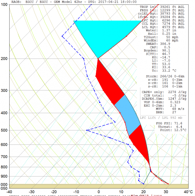
Some of the forecast soundings are equally impressive. Below is a forecast sounding for Manchester at 1800Z on Wednesday evening. While there is a warm nose to overcome near 800mb, given that surface temperatures could well be nearing 30C here, along with some unusually high Td’s, then it does lead to very unstable conditions from a UK’s point of view. Excessive amounts of CAPE would be available, leading to severe storms. As a result, if the convective activity does develop, then flash flooding from large amounts of rain would occur, large hail and extremely frequent lightning too, along with high wind gusts.
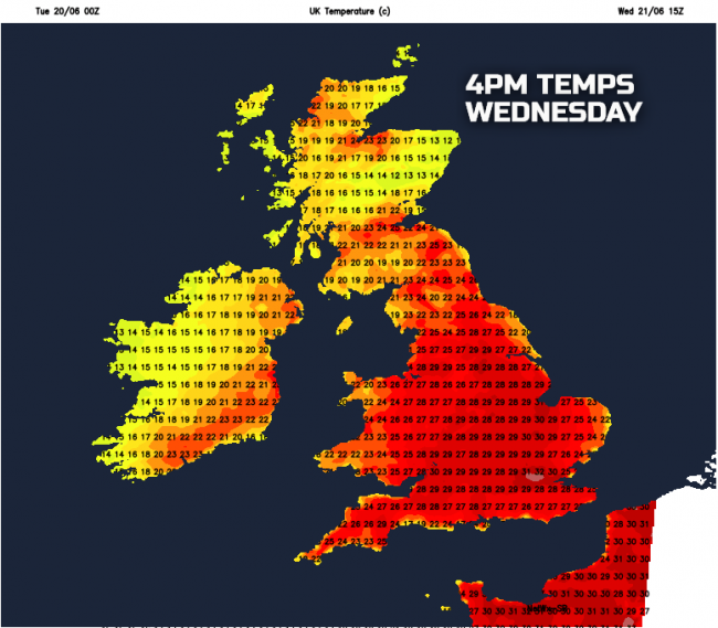
The other main feature of Wednesday’s weather is indeed the temperatures. Except for cooler conditions across parts of Scotland and Ireland, it is across England and Wales where temperatures will soar. Maximum temperatures widely ranging between 25C and 30C is forecast, but some urban areas may well see temperatures range between 32C and 35C. It is predicted that temperatures on Wednesday afternoon could well produce the highest June maximum in quite some years, perhaps going back to the 1990’s or earlier.
Thu 22nd June: Through into Thursday and the transition of the upper trough moving across the UK and interacting with the WBPT could well mean that some overnight residual storms and heat and humidity are present across E and SE first thing. However, the central aspect of the forecast on Thursday is for the flow across the N Atlantic and into NW Europe to become more progressive, leading to a far cooler and fresher air mass filtering across many areas. The short-wave will have cleared to the E through the day, and a minor ridge follows, with predominantly anticyclonic conditions. However, a new developing surface low pressure, along with its associated frontal zones will arrive into the N and W later in the day.
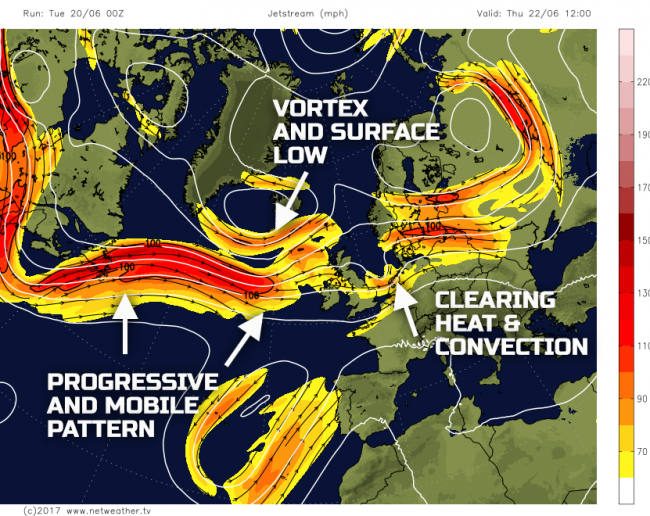
Any residual thundery conditions will clear to the E through the morning, and then many areas will have a reasonable day. A few scattered showers are possible, but with a transient ridge bringing anticyclonic conditions, a mainly dry day with some bright or sunny spells is forecast. More persistent, frontal rain, will then move into Scotland and Ireland later in the day, along with a strengthening wind.
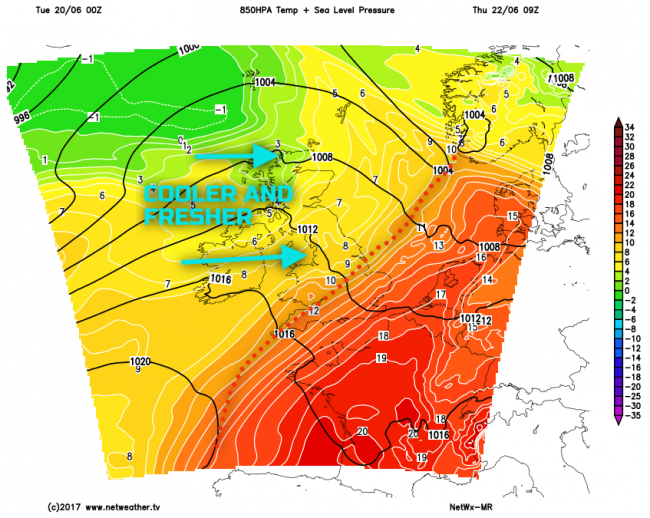
The main feature of the weather will be how cooler and fresher it will feel for many. SE England may hold on to some residual heat and humidity for most of Thursday, but the hot and humid weather of the preceding days will come to an end. Highlighting this is the 850mb temperature chart for early Thursday, noting the thermal plume (high WBPT) clearing to the E and SE, as a cooler, fresher, air mass moves in off the N Atlantic.
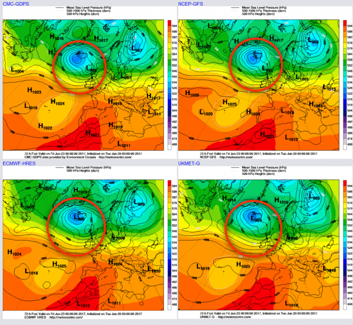
Fri 23rd June: We end the working week with markedly different conditions than compared with the beginning. A zonal pattern will have become established, and all the leading GM’s (UKMO, GEM, ECMWF and GFS) are in good agreement for an area of low pressure to be present just to the NW of the UK through the day. Associated frontal zones will be moving SE through the day, weakening as they do so, but bringing some precipitation, while showery conditions following into many N and W areas. It will also be a noticeably breezy day with winds W’ly moderate or fresh. The overall difference in the ‘feel’ of the weather than compared with preceding days really will be quite marked, with many areas having much lower temperatures, perhaps as much as 10 degrees lower.
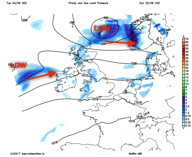
Sat 24th and Sun 25th June: So, we move into the coming weekend with an area of low pressure tracking to the N of the UK and with an unusually zonal pattern across the N Atlantic and into the British Isles. There are uncertainties over the details, but some showery weather is likely across the N on Saturday, perhaps easing for a time, before a new area of low pressure moves in from the W and SW during Sunday.
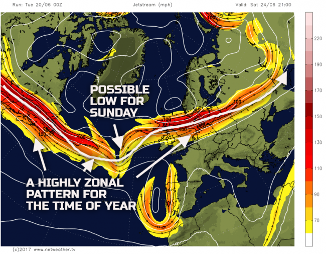
There are model differences over the details, especially regarding the arrival of another low pressure from the W within the W’ly flow. What does have some confidence though, is it is likely to be N areas of the UK that see most of the showers on Sat. The showery weather associated with the LP tracking to the N, before clearing into Sunday and this may well then lead to a reasonable day across England and Wales on Sunday, still far cooler than of late but pleasantly warm. At the same time, though the wet weather may well return to more W areas, as this potential low arrives, this overall evolution is highlighted well by our MR model.
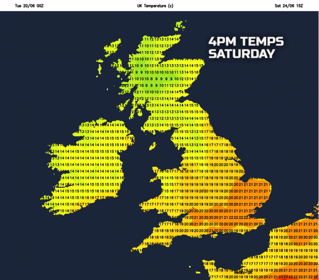
Highlighting the cooler conditions is the current predicted temperatures for Saturday. These are subject to change, but an overall range in temperatures between 13C and 20C is forecast, always coolest across parts of the N and W.
Medium and Longer Term 26th June onwards:
Looking ahead towards the end of June and into early July, confidence remains quite low in the possible evolution. A combination of some poor model agreement, but also the time of year which is often a rather volatile period, when ‘short and sharp’ changes in the weather can materialise. It doesn’t take much of a backing of the flow to more of an S or SW’ly, ahead of an approaching low pressure to lead to quite a quick rise in temperature for example. This evolution can appear within a short period and is very difficult to model at longer lead times.
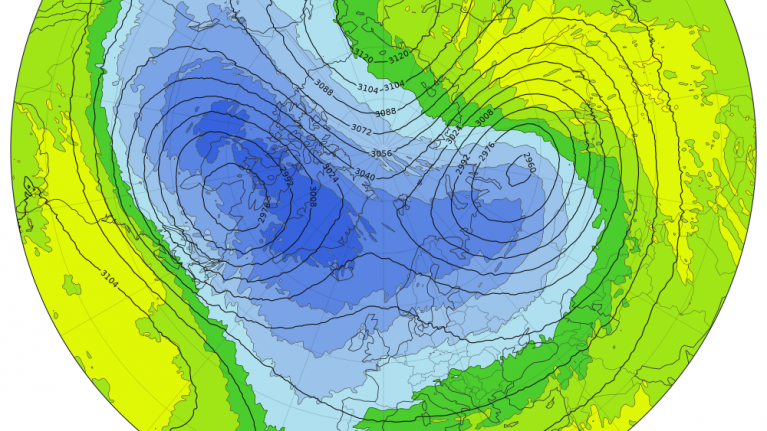
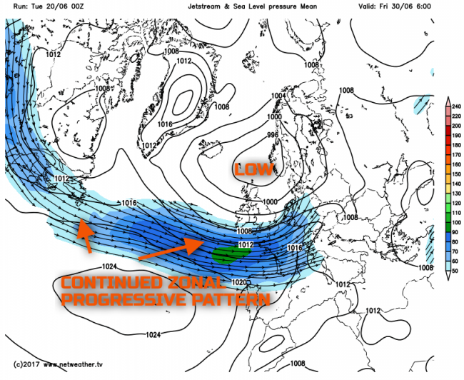
However, the current thinking is that it is low pressure and unsettled conditions that will prevail now through the end of June and most probably into early July, with little risk of any sustained summer weather developing. There is some model agreement between the EC ENS and the GFS ENS, along with the likes of the EC32 (EC Monthly) as well. Quite a big –ve pressure anomaly is forecast to develop over or to the N of the UK, with a S’ly tracking jet and the 00Z GFS ENS below, for Fri 30th, highlights this pattern very well. As a result, if you’re looking for some summer weather to return, then you could well be disappointed.
Loading recent activity...