Issued at 1500GMT on Tuesday 21st Mar based on 21st Mar 00Z Model Runs
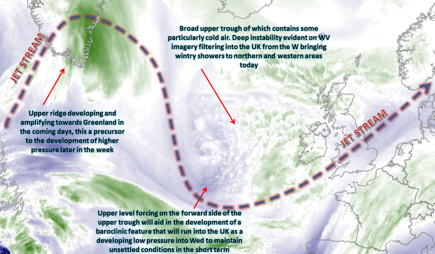
Wed 22nd Mar: Into Wednesday and the broader pattern across the N Atlantic and into the UK domain is one of high confidence, despite it being a particularly complex synoptic pattern. The overall jet stream will be one of amplification with a building ridge to the W and NW of the UK, whilst the UK firmly remains within the base of an upper trough of which will contain surface cyclonic conditions across the UK. The building ridge to the W and NW of the UK will have a some influence on the UK’s weather towards the end of the week, as it combines with trough disruption to allow for a rapid build of GPH into the UK from the W. This then signalling a far more settled and benign period of weather from Friday onwards. This highly amplified pattern is evident on the jet stream chart below.
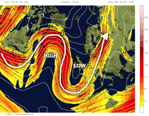
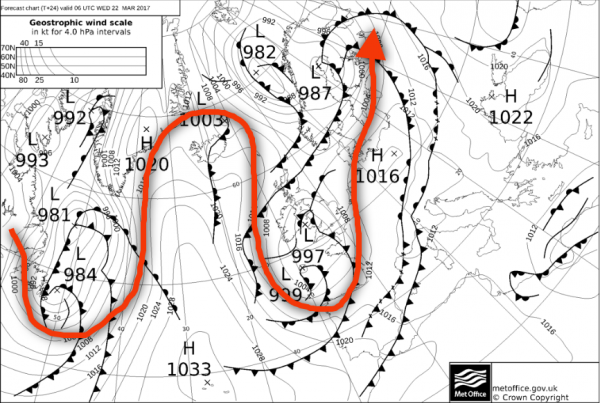
The resultant weather across the UK on Wednesday will be complicated and complex. On the forward side of the upper trough over the UK will be a marked region of forcing that will engage a baroclinic region to the SW of the UK on Tuesday night and through into the early hours of Wednesday. This will develop into a surface low pressure, with associated frontal zones, as it moves northwards across the UK during the day. The development and track of this low pressure are what is uncertain, but it is likely to bring an awkward mix of conditions across England, Wales and S Scotland through the day with rain, showers, sleet, and snow all to be expected. Wet weather will be moving northwards across England and Wales first thing, especially across more central and western areas with some sleet and snow developing across higher ground of N England northwards. As Wednesday progresses, the main surface low pressure is expected to become slow moving within the base of the upper trough with the associated frontal zones set to stall across parts of Ireland, N Wales, N Midlands and N England. It is within this zone that a lot of rain is expected through the day, perhaps bringing some localised flooding, while some sleet and snow is expected as well.
To the N of this region, across central and northern areas of Scotland, pressure will be rising and, as a result, the weather will be far less inclement here. Equally across more central and southern England conditions will become somewhat drier and brighter before sunset. The UKMO FAX chart for early Tuesday highlights this complex development as low pressure moves into the UK and becomes slow moving. The amplified jet stream pattern is, once again, highlighted.
Thu 23rd Mar: As we move into Thursday and all the main GM’s (UKMO, ECM, GEM, GFS and JMA) indicate a steady rise in GPH across the N of the UK. This will, as a result, lead to increasingly anticyclonic conditions across Scotland and Ireland through the day with mainly dry and fine weather, along with some sunshine too. It will be a cold start however across the N and W of the UK with a frost and perhaps some icy patches. The slow moving nature of the surface low pressure across England and Wales means that conditions on Thursday will still be, overall, cyclonic across England and Wales. The surface frontal zones while losing any significant forcing will still be bringing precipitation to parts of England and Wales, most probably across parts of N England. The 00Z GEM model highlights this general evolution well as we move into Thursday.
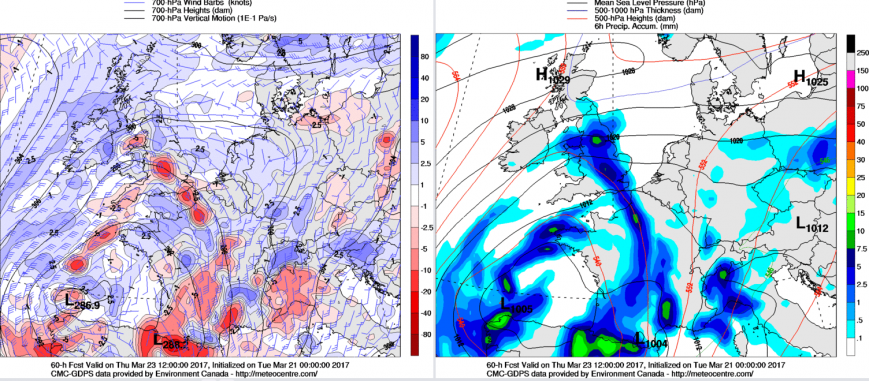
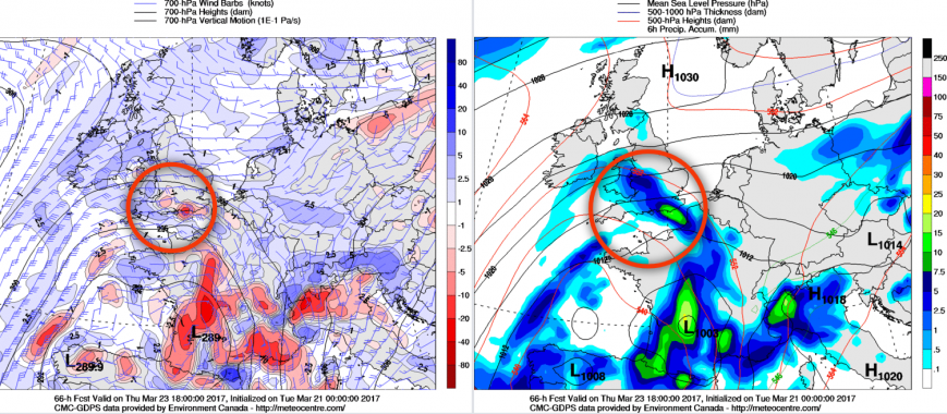
The combination of rising GPH across the N and lower GPH to the S means that an increasingly strong PGF will develop across England and Wales, with a fresh or strong E or NE’ly wind developing across parts of N England and Wales, at the moment. This will accentuate the on-going cold weather especially given a lack of any sunshine beneath rather extensive frontal cloud. As pressure continues to rise though towards the end of the day and trough disruption begins to take place, then conditions across the UK will become increasingly settled by the end of Thursday. That being said some of the models, including the GEM, UKMO and ECMWF for example, do bring a renewed region of precipitation into southern counties of England on Thursday evening and overnight, perhaps some heavy rain possible too for a time and also windy. So the far south of England may well have to endure a wet and windy night on Thursday. This general evolution is highlighted well by the GEM noting the region of vorticity across some S Counties of England at 1800Z along with an area of heavier precipitation.
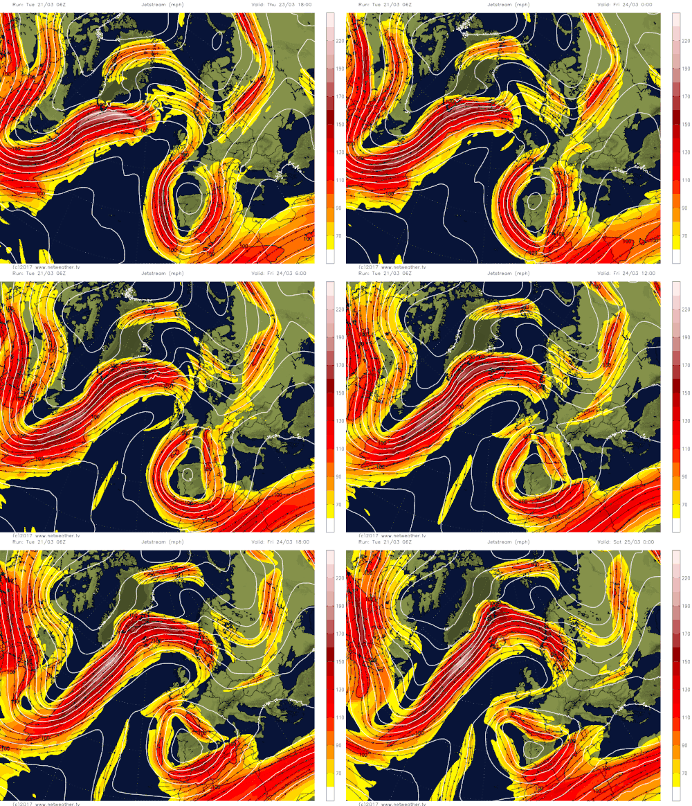
Fri 24th to Sun 26th Mar: As we move into Friday and this is when the weather will rapidly begin to settle down in many areas of the UK. The building ridge of high pressure to the W and NW of the UK during Wednesday will have toppled down into the UK as part of a process known as trough disruption. The upper trough that will be over the UK within the short term will disrupt and then become a cut-off surface and upper-level low (ULL) to the S of the UK over France and Iberia. This process of trough disruption means that the cyclonic pattern across the UK sinks southwards, while GPH rises rapidly and the UK sees a quick transition to far more settled conditions. This process is exampled well by the animation of the jet stream from the GFS below, noting how the upper trough over the UK, in particular, disrupts and then becomes a cut-off low pressure.
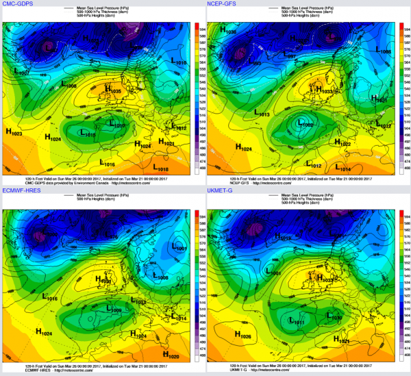
The weather to end the week is then dominated by high pressure. It will be a cold start to Friday across many central and northern areas of the UK beneath the main surface high pressure, perhaps very cold in some sheltered rural areas with temperatures below -5C or so. There may well still be some residual rain and showers across the far south of England for a time during the day, but this will eventually clear, and there is some uncertainty over this at the moment. The fine and settled period of weather will then continue into the coming week as a surface anticyclone dominates the weather. Both Saturday 25th and Sunday 26th will produce some very pleasant conditions indeed, of which will be a complete contrast to just a few days prior. Both days will be dry with some bright or sunny spells, these perhaps prolonged at times, but nights will still be cold with frost fairly widespread, along with some mist and fog patches too. The 00Z UKMO, GEM, ECMWF and GFS at 0000Z 26th highlight this cyclonic pattern across the UK with the cut-off vortex now to the S of the UK over Iberia and S SFrance.
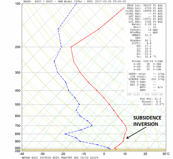
The forecast sounding below, for Manchester, early on Saturday morning highlights the expected atmospheric conditions well, with a marked subsidence inversion in evidence in conjunction with descending air beneath the main surface high pressure. As a result, a lot of dry air is forecast beneath 800mb in particular, and this does, as a result, mean that plenty of cloud breaks are likely into the weekend so plenty of spring sunshine as mentioned, but conversely means clear skies and chilly nights.
Temperatures, within the short term, will remain below average and this is shown by our GEFS ENS mean v climate averages between the 22nd and the 24th, with most of the UK quite cold. However, the important aspect is that temperatures will respond to the build of pressure later in the week, into the weekend and beyond with some very pleasant spring days with temperatures up to near or slightly above average and feeling pleasantly warm in the sunshine too. As indicated earlier; nights will remain cold with a large diurnal range of temperatures to be expected.
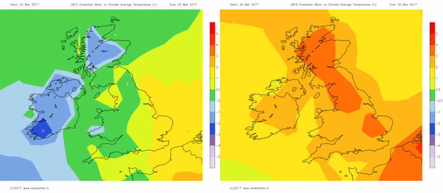
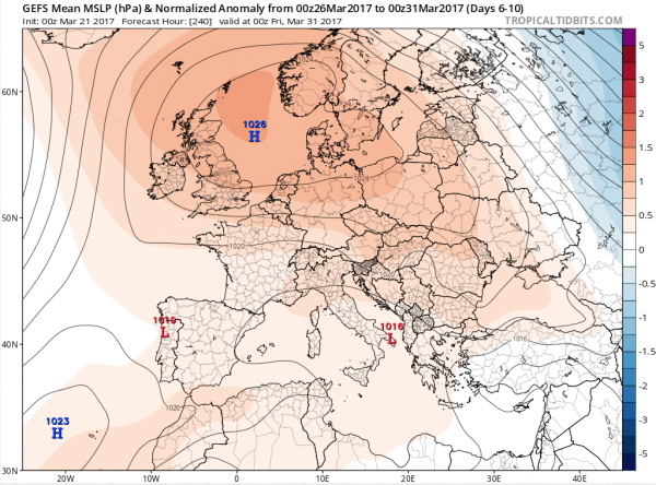
As we look towards the end of March and into early April there has been a consistent signal within the longer range models for high pressure to be a dominant feature with a blocking pattern become established across the UK to end the month and move into early April.
Details aside, there has been some good model consistency too regarding this evolution. As a result, confidence is relatively high, despite the time frame, for the fine and settled period of weather that develops to end the week to then continue throughout the final few days of March and most likely continue into early April. The 00Z GEFS 5 day mean covering the 26th to 31st March highlights this general evolution well towards the end of the month with clearly a strong +ve pressure anom across the UK and NW Europe in general, highlighting this settled outlook. There is support for this evolution from the likes of the EC EPS and EC Monthly as well, so a very pleasant and spring-like period of weather is expected to end March.
Loading recent activity...