Issued at 1500GMT on Tuesday 24th Jan based on 24th Jan 00Z Model Runs
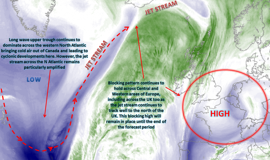
Wed 24th: As we move into Wednesday and the blocking pattern that has dominated for several days will continue. All the main GM’s are in good agreement over the main centre of gravity of the high pressure being across parts of Germany and central areas of Europe in general with a central pressure of around 1032mb. The long wave upper trough across the W Atlantic remains in place, whilst a large amplified pattern then dominates across the N Atlantic and into NW Europe with the main jet stream passing well to the north of the UK. This is exampled well on the below chart from the GFS, noting the large meridional (north to south and south to north) flow across the N Atlantic between Newfoundland and Scandinavia.
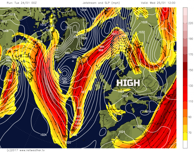
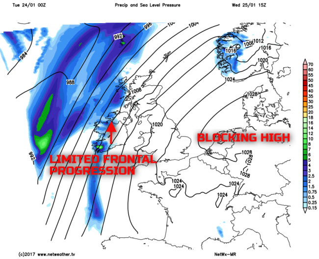
The block will remain in place across the UK through the course of the day but the UK will begin to lie on the edge of the blocking regime as a more mobile pattern tries to establish itself across the N Atlantic as the long wave upper trough edges eastwards. As a result, an increasingly substantial PGF is forecast to setup across the UK through the day, especially across more northern and western areas of the UK with an increasingly strong or near gale force S or SW’ly wind developing, this certainly a feature of the weather through the day across Scotland and Ireland. Frontal zones, associated with the general cyclonic pattern to the west and north-west of the UK, will bring thicker frontal cloud into more northern and western areas through the day with some precipitation possible, but the precipitation fragmenting with time as forcing relaxes away and it is likely only to be W Scotland and W Ireland that sees any. For the majority of the UK, the regime of the last several days continues, and that is for mainly dry and settled conditions with some bright or sunny spells, but variable cloud. Overnight mist and fog a potential hazard still across more central and south-eastern areas of England but with a strengthening breeze for all of the UK really then Wednesday will be the last day fog is likely to be an issue this coming week. Our MR forecast model highlights this general pattern for Wednesday.
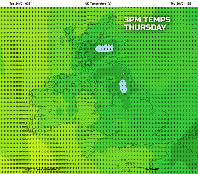
Thu 26th: As we progress into Thursday and some interesting developments take place from the south. First and foremost the ECM, UKMO, GFS and GEM all maintain the general, broader synoptic pattern across Europe and the N Atlantic and that is with a large amplified pattern in evidence as an upper trough tries to approach from the west, but with the blocking holding to the east. As the block declines further, deeper into Europe, it allows the flow to back more into a southerly direction through Thursday. Now, more often than not, a S’ly direction or air mass from the south is not often cold, but it will be on Thursday. In what is likely to be the coldest day of the week there is expected to be a significant advection of cold air off the near Continent, out of France, through the course of the day. The cold air is particular shallow, so the highest hills and mountains of the UK on Thursday will generally experience much higher temperatures than lower down.
850mb temperatures, theta-w and theta-e from the same elevation don’t provide good guidance on the air mass type at all and would, on face value, signal a relatively mild day.
However, on closer inspection of forecast soundings you can clearly see the cold or very cold conditions within the boundary layer, but with much milder air directly above. The forecast sounding below, for Manchester, at 1500Z on Thursday, highlights sub-zero Td’s and a depressed temperature. When this is coupled with a fresh or strong S or SE’ly wind it really will feel particularly cold, with a significant wind-chill factor.
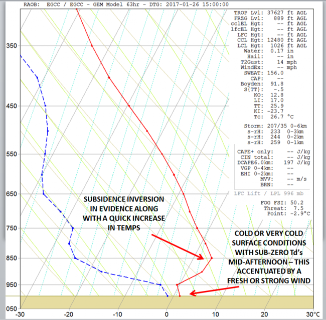
The overall weather for the day is for some frontal precipitation to again be in evidence across W Ireland as frontal systems try and move into the UK, but overall for most of England, Wales and Scotland it is again a dry day with some bright or sunny spells. These perhaps prolonged in association with the colder and drier air mass off the near Continent aiding to break up any Sc or ScCu type cloud given the strong subsidence inversion too. A cold day is expected across most of the UK with frost, perhaps harsh and penetrating frost given sub-zero minimum temperatures combining with a strong breeze. Some parts of Scotland and N England may experience an ‘ice day’ in where temperatures don’t rise above 0C for the full 24 hour period as well.
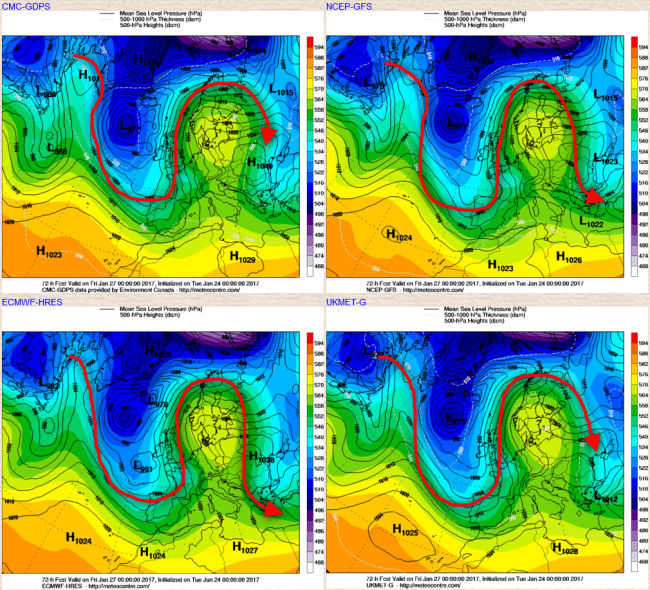
Fri 27th: By the time we get towards Friday the blocking high to the east really will be declining into central and eastern areas of Europe as the broad upper trough, along with cyclonic developments at the surface try and move into the UK. The overall pattern is still meridional across the N Atlantic and into NW Europe with, again, the upper trough just to the west of the UK, but with a positive 500mb height anomaly to the east of the UK. The UKMO, GEM, ECM and GFS are all in fairly good agreement regarding this pattern and, as a result, this does mean that the upper pattern will become increasingly cyclonic across the west of the UK in particular on Friday.
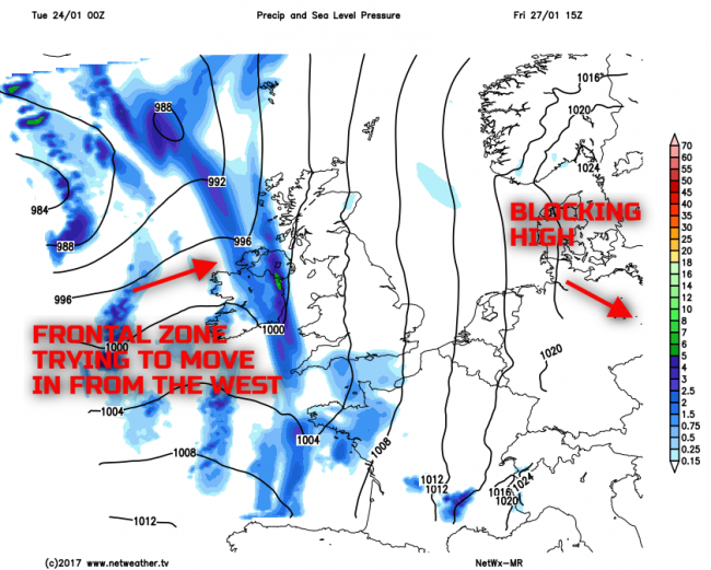
The details of the forecast for Friday are still somewhat uncertain, but it is likely to be a cold start across England and Wales, perhaps Scotland too with yet another frost but fog is unlikely given a still fresh or strong S’ly wind off the near Continent. Frontal zones will be making more progression into western areas of the UK through the day and W Scotland, Ireland, Wales and SW England could well be at risk of some rain and showers developing through the day, perhaps locally wintry on high ground. Generally, though the overall dry regime for most of England will continue, perhaps across most of Scotland as well, away from the west with some bright or sunny spells still. It will remain cold for most, but with milder conditions, or at least less cold conditions moving into western areas through the day which our MR model highlights quite well.
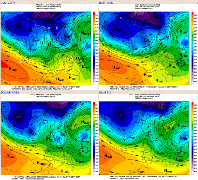
Sat 28th and Sun 29th: As we progress into the coming weekend and the UKMO, GEM, ECM and GFS continue to signal a slow progression towards more unsettled conditions, but this isn’t straightforward and, as a result, the details for the weekend’s weather at this stage are unknown really. The main blocking high continues to decline away to the east and is replaced by more of an upper trough over the UK, something which the ECM, GFS, UKMO and GEM GM’s all indicate at least into Saturday. As a result, some frontal progression into the UK is expected during Saturday with some showery outbreaks of rain possible, but with the fronts generally becoming slowly moving across the UK and then potentially fragmenting as upper forcing relaxes as well. So a cloudier day for most on Saturday at the moment, with some showery rain trying to move eastwards. Differences then emerge with regards to Sunday with the UKMO and ECM showing a COL situation across the UK as an upper trough or closed upper-level low becomes situated just to the east of the UK but with then some limited progression towards a rise in pressure. This, however, is at odds with the GFS and the GEM which are far more progressive during the second half of the week with more in the way of milder, wetter and windier conditions developing.
This general split in the GM’s can be seen on the below charts with most certainly the ECM and UKMO generally maintaining a colder regime overall through the weekend with an on-going risk of frosts by night and perhaps some icy patches too. The details of the forecast for the weekend will unlikely be known for a number of days and more model consistency is required as to whether the more mobile, aggressive pattern from the likes of the GFS is likely to develop, or whether the progression to more unsettled weather is a slow one as per the ECM and the UKMO. At the moment the UKMO and ECM models are preferred for the weekend, so the colder and less cyclonic regime is currently expected.
The progression towards more unsettled conditions after such a significant blocking pattern always seems to be a problem for the model to resolve, and this time last week the outlook was indeed for far more unsettled conditions to arrive during this current week, but clearly they won’t or not for most of the UK anyway. The general thinking at the moment, especially after inspection of all the GFS and EC ENS is that eventually, at least the more mobile pattern will win out and, as a result, the final few days of January and into early February will become more unsettled across all areas of the UK with spells of wet and windy weather, along with a general rise in temperature. The MJO remains in phase 1, but will soon move through phase 2 and phase 3, this has been expected for a week or more now, and this phase does generally relate to a more cyclonic pattern across NW Europe, as exampled below.
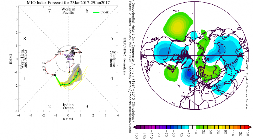
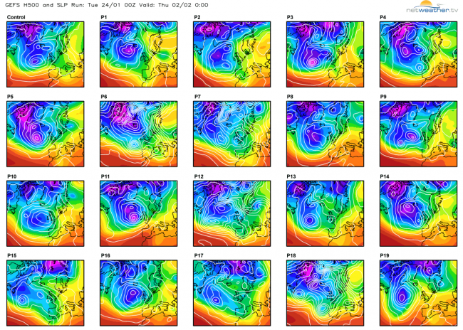
As a result, whilst it will take some time to eventually break down the block the overall thinking is still that of a far more cyclonic period of weather will develop across the UK as we move through into the final winter month. Whether that pattern will then become established for a number of weeks, as it can often do, is hard to determine yet. But whilst this blocking regime at the moment is proving to be a very stubborn setup to breakdown, the consistent signal is that eventually a more mobile regime will become established as a change in weather type develops across the UK. There is, however, a low risk of the blocking returning and allowing for more of a SE’ly flow to develop once again along with perhaps some trough disruptions too. Some of the GFS ENS members do show this, for example, member 13, 15 and 17 and there is some element of this within the EC ENS too. But, for the time being at least, a return to a blocking regime that we have seen over the last 7 to 14 days during early February is highly unlikely, and the more cyclonic evolution is preferred as we move into February.
Loading recent activity...