Issued at 1000BST on Monday 3rd Oct based on 3rd Oct 00Z Model Runs
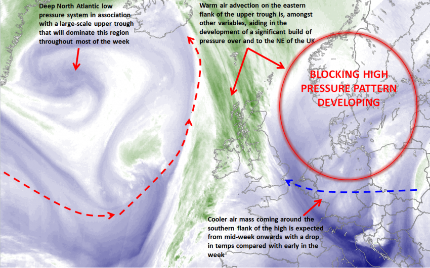
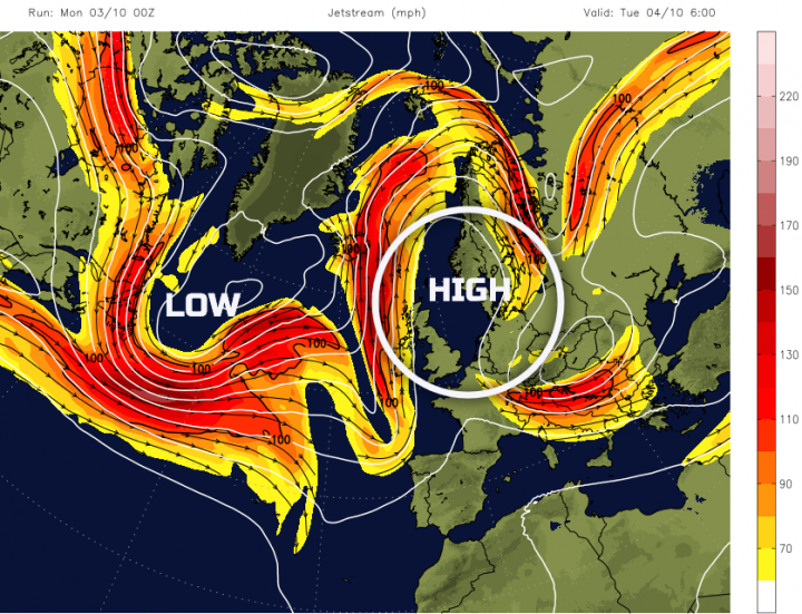
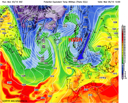
Mon 3rd: Forecast model agreement is good regarding the synoptic developments through the remainder of Monday with the main GM’s (UKMO, GEM, GFS and ECMWF) all highlighting a large scale upper trough within the N Atlantic and with warm air advection on the eastern flank of the high pressure allowing for a build of pressure over and eventually to the north-east of the UK. A cut-off upper vortex is in evidence to the east of the UK, the residual low from Saturday’s wet weather across England and Wales, but this will clear through the day and into Tuesday, and it is the blocking high over Scandinavia that then becomes the dominant feature of the weather over the next 24 hours. All Det models indicate a build of pressure of up to around 1044mb by the time we end Monday and into Tuesday across Scandinavia as a highly amplified and blocked weather pattern develops and this can be seen well on the below-forecast chart in association with the large-scale jet stream pattern. It should be noted though that a frontal system, associated with low pressure within the N Atlantic is bringing frontal precipitation to parts of Ireland through the day, but primarily restricted to the western half of Ireland. This risk of precipitation here will continue through into Tuesday before the risk eases thereafter.
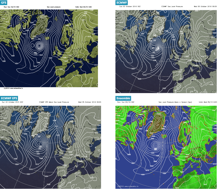
Tue 4th to Fri 7th Oct: The majority of the coming week can be grouped together this week given that the blocking regime will dominate the broader weather patterns throughout these days with little overall change in the expected weather. The large scale development of a blocking high pressure system over Scandinavia is what will dominate the weather throughout the rest of the week. Within this regime, it is more local and smaller-scale boundary layer issues that provide the greatest forecasting ‘headache’ with regards to cloud amounts and how this will affect sunshine amounts and also the development of a cooler air mass too. Overall, though, looking at the broader picture, the weather across all areas of the UK will be dominated by high pressure and an anticyclonic SE’ly air mass. This can be seen well on the below-forecast charts including the GFS, ECM, ECM EPS and the GFS ENS for Wednesday. Note the large high pressure over Scandinavia ‘holding’ frontal systems and low pressure areas to the west of the UK in what is a particularly amplified pattern.
Forecast soundings do show some limited instability within the boundary layer through the coming days and this, is likely to mean that regions of cumulus and stratocumulus clouds will develop at times and bring cloudier periods. However, this is unlikely to stop bright or sunny spells from developing at times as well and, more regionally at least, these will be prolonged. One important aspect of the forecast is the development of a gusty SE’ly wind through towards the middle of the week. This is signalled well from all forecast models and sustained wind speeds of 15KT to 20KT is certainly likely across the UK and with higher gusts towards the middle of the week in particular. The other noticeable feature is the arrival of a cooler air mass around the southern flank of the high pressure.
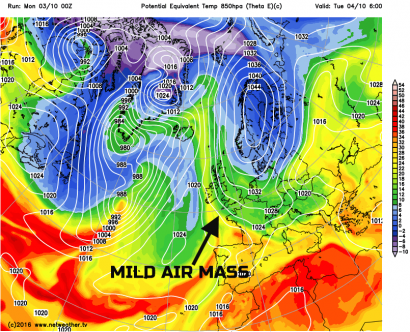
Despite it only being early October the source origin for the air mass from Wednesday onwards is from the far north-east of Europe and almost into western Russia, this is still a cool source at this time of year. As a result all the main global models do indicate a drop in 850mb temperatures from mid-week onwards, but more noticeably a drop in theta-e/theta-w which are particularly important variables at this time of year and beyond for picking out changes in air mass. This variation can be seen very well when Monday’s theta-e (equivalent potential temperature) from the GFS model is compared with that of the expected theta-e values by mid-week, clearly note the blue shading highlighting this cooler air mass moving into the UK from the south-east around the southern flank of the high pressure. The arrival of this cooler air mass will be more pronounced when it combines with the relatively gusty winds from the SE and this, will make for quite a chilly feel to the weather, especially where there is some relatively low-level cloud and not much in the way of sunshine. It should highlighted though that the breezy conditions will generally preclude the risk of any cold nights with little risk of frost in the coming nights, but the risk of frost may return late in the week as the PGF (pressure gradient force) eases out and the overall flow becomes far less pronounced from the south-east.
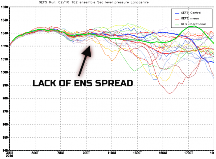
Sat 8th and Sun 9th Oct: Into next weekend and overall the majority of the forecast models, including the GFS ENS and EC ENS maintain the blocking pattern to the NE of the UK with a major ridge of high pressure still extending south-westwards from the main high across the UK. As a result, given some model consistency as well, confidence is relatively high to suggest that the fine and benign period of weather will be maintained into next weekend as well across the UK. Clearly, there is uncertainty over the details, especially regarding boundary layer conditions and how much sunshine may or may not be present and equally what amount of cloud may be in evidence too. Perhaps with enough depth to lead to some light showers or patchy precipitation across eastern and south-eastern areas of England off the North Sea, but this is an uncertain development. However, the cooler air mass that arrives from mid-week is still likely to be present beneath the high pressure, and there may also be a combining factor of the boundary layer cooling progressively due to chilly nights as the overall flow becomes less significant with lighter winds. The overall weather-type for next weekend is likely to be one characterised by bright or sunny spells, but with some regions of cloud, average temperatures, but with a greater risk of overnight mist and fog patches, along with ground frost given lighter winds, but clearly this is dependent on cloud amounts by night. The GFS ENS pressure graph, for Lancashire as an example, highlights the relatively high confidence for further high pressure next weekend given the lack of ENS spread in evidence. Impressively the GFS ENS maintains atmospheric pressure above 1025mb even into early next week before a greater spread becomes apparent in association with a potential breakdown to a more unsettled pattern.
Loading recent activity...