A ridge of high pressure will build in for Saturday bringing fine weather for most after a showery end to the week in the south. However, rain pushes through Sunday morning, followed by a brief lull before Storm Floris brings gales to the north on Monday.
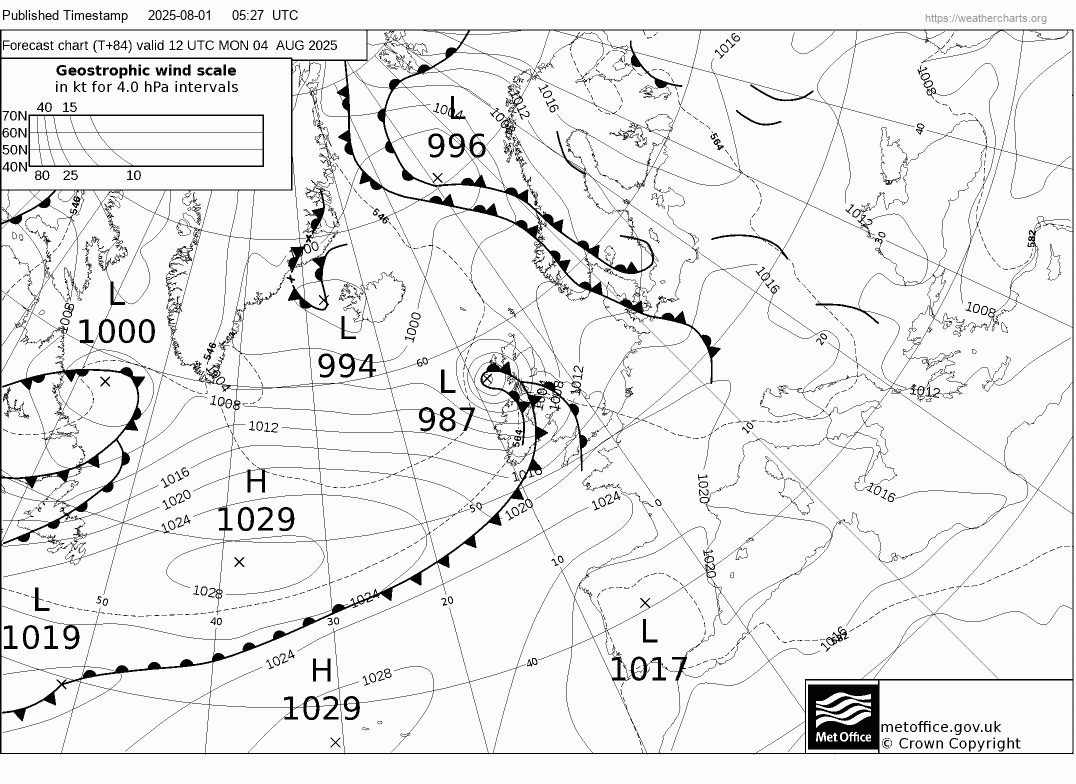
A strong jet stream ploughing across the Atlantic over the coming days will be in the driving seat steering the fortunes of the UK weather as we start August. And that means the weather will be changeable and, at times, rather unsettled – particularly early next week, as Storm Floris, named by the Met Office, moves across Scotland on Monday – bringing unseasonably strong and disruptive winds to northern parts of the UK.
The low that will become Storm Floris is currently a fairly innocuous shallow low off the eastern seaboard of the USA and will be south of Newfoundland early Saturday morning. The low then crosses Atlantic over the weekend, not really deepening much. It’s not until it moves from the warm side to the cold side of powerful jet stream crossing the North Atlantic on Monday morning, that it will rapidly start to deepen in the developmental left exit of the jet stream, where winds diverge aloft, causing winds to converge at the surface creating a drop in surface pressure.
Some uncertainty over how deep the low will get. Some runs of models have been deeper than others today, but most are within the range of the low deepening as low as 981-984 hPa off northeastern Scotland. This is unseasonably deep for early August and will bring a risk of gales across the north, perhaps severe gales around coast and over hills.
However, after Storm Floris moves away, there are signs of the weather calming down, as high pressure builds in behind the departing early week storm. So from mid-week hopefully some warm sunshine and lighter winds.
Yesterday saw thunderstorms develop across southern Britain, slow-moving storms across the south coast of England caused some issues with flooding. On the Isle of Wight a thunderstorm caused flooding of streets and structural damage to a supermarket: a Sainsbury’s supermarket had to be evacuated due to the partial collapse of the ceiling and flooding of the aisles.
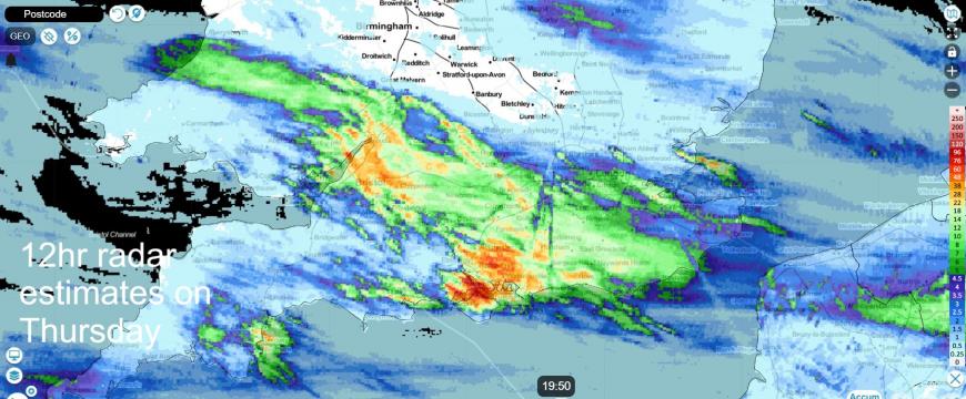
Still some showers around for SE England this evening, but thunder more isolated and generally the showers are not causing any issues. Otherwise, a mostly dry and fine summer’s evening for many.
A ridge of high pressure will build from the west on Saturday, ensuring a fine and dry day with good sunny spells for most. Feeling warm in the sunshine too.
However, it’s downhill as we head into Sunday, as an Atlantic frontal system moves in and brings spell of rain eastwards in the morning, heavy in the north, lighter and more patchy in the south. However, it should turn drier and brighter from the west into the afternoon for most, though cloud and rain may linger for a time across southern England.
Monday will feel autumnal rather than resembling high summer for all, as the centre Storm Floris, an useasonably deep low for the time of year, tracks northeast across northern Scotland in the afternoon or evening, bringing a spell of wet and windy weather across all parts. Rain will be heaviest and last longest in the north, lighter and more brief in the south. But the winds will be the biggest issue. Gusts of 60-70mph possible along exposed coasts & hills in the north Monday and early Tuesday looking at the strongest gusts indicated by models - especially across Scotland. This is likely to cause disruption to travel and also outdoor events, anyone planning on camping or walking may want to take precautions too.
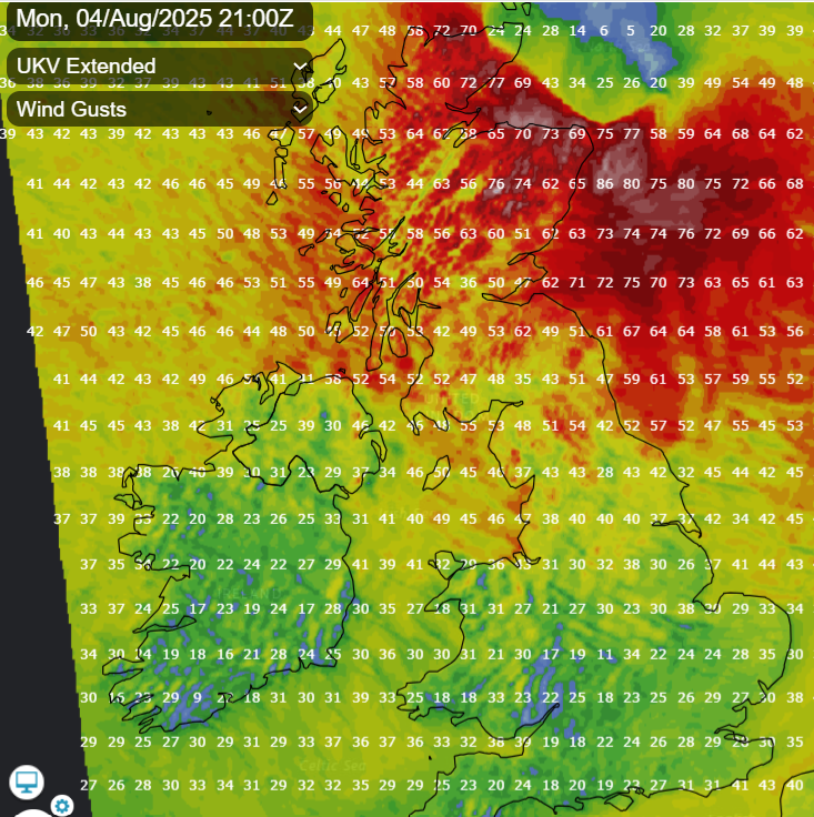
A Met Office yellow weather warning has already been issued for the whole of Scotland, N. Ireland, the north of England and north Wales, with gusts widely expected to reach 40-50mph, with 60-70mph likely for coasts and hills.
As mentioned, turning calmer, drier, sunnier and warmer by mid-week, with temperatures in the low to mid 20s, though it may turn unsettled again at the end of the week.
Loading recent activity...