The UK Met Office has issued a yellow wind warning for Thursday night and Friday morning over southwestern Britain. This is four days away, but people might be planning to travel at the end of this week, with half-term holidays in Wales and Devon coming up.
“A period of strong winds may lead to damaging gusts and transport disruption.”
This is a heads-up about an incoming Atlantic low pressure. The models aren’t agreeing at this stage. It might just be an autumnal low pressure bringing a spell of wet and windy weather across Britain. It might be a deeper low that heads over southern Britain with gales for the English Channel and northern France or if the low centre is further north over Wales and the Midlands, it could be southern England with wild weather.
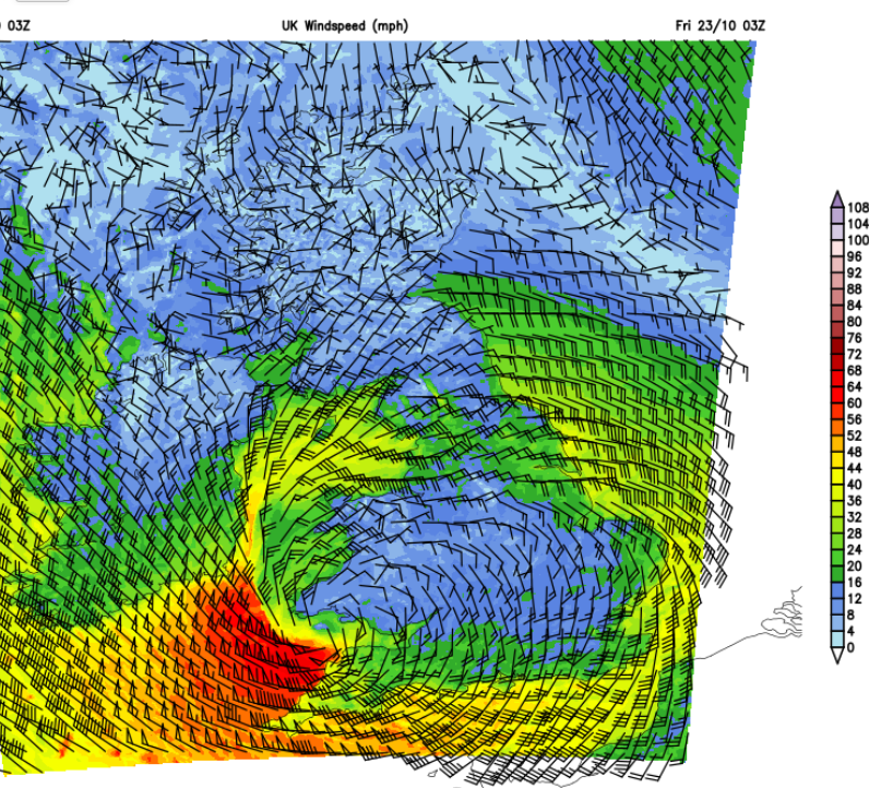
“Strong west to northwesterly winds may spread across southern parts of England and Wales on Friday. Gusts of 50-60 mph are possible, and some coastal or exposed areas could see 70 mph or more, but at this time there is uncertainty in where the strongest winds will be.” MO
A weather warning is made up of the map with coloured areas on it, text explaining what could happen and the Met Office forecaster’s remarks, and also a matrix. There have been recent changes to the structure of the matrix; the axis are different.
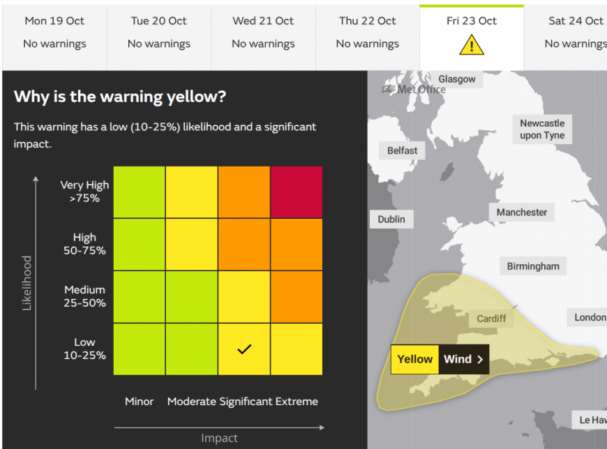
This warning has a low (10-25%) likelihood and a significant impact.
As this is still some time away and there is some disagreement in the models, the warning has a low likelihood when issued on Monday. There could be severe weather, but it is not certain at this time. Likelihood is combined with the level of impacts. Above Minor and Moderate, Significant impacts have been chosen. As time goes by, the tick might move up the Likelihood scale.
Parts of the UK could end up with an Amber wind warning, perhaps Yellow rain warnings too as the ground is so hard after the long hot and dry summer; surface water flooding is a concern. It might be Meteo France issuing wind and rain warnings too.
This low pressure might become a named storm. If the main impacts will be for Britain (or southern Ireland) then it would be named Storm Austen. If the main impacts would be over northern France, then Meteo France might decide to name the low, 'Bruna'.
The first name from the southwestern naming group (Adam) has been used over the weekend for a DANA event. Rather than a windstorm, Spanish AEMET are also naming isolated cut-off low pressures which can bring torrential rain and disruptive flooding.
This week
During Tuesday night, a developing low pressure will move over the Irish Sea and bring some lively downpours and gusty winds to County Down, Pembrokeshire, north Devon and north Somerset before dawn on Wednesday. This isn’t the low we are talking about but it will bring some wet and windy weather to Wales and the Bristol Channel on Wednesday morning. This moves over NW England, the Yorkshire Dales and the Peak District in the middle of the day with heavy rain but also freshening winds over the southern half of Britain around the deepening low. The northwesterly winds over the Irish Sea could add a certain something to midweek ferry journeys and it will be windy for Merseyside and the north Wales coast.
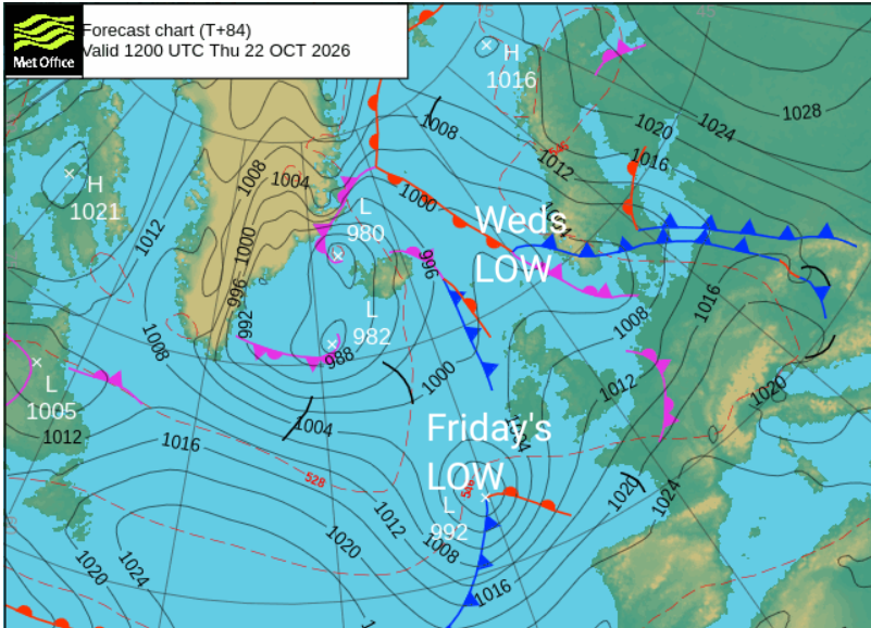
The strengthening westerly winds along the English Channel will need keeping an eye on with a potentially wild spell for Kent on Wednesday afternoon as the southwesterly winds begin to veer. We will have to see where this low pressure tracks but the 03Z run of the UKV model had it slightly further south, with gales along the Straits of Dover. The 09Z run had the low not as deep and its centre path across central Britain as does the Arpege model. The whole lot will be clearing away over the North Sea by the end of Wednesday, with a sunny lull on Thursday.
UKV wind arrows showing full barb 10mph, half barb 5mph and pennant 50mph
There is uncertainty for Thursday night and Friday: how far north the rain bands will reach, where will see the strongest winds and from which direction, the sea states for ferry crossings and flood risk.
The Environment Agency in England is already highlighting: “Local inland flooding is possible but not expected in parts of England on Thursday and Friday. Local coastal/tidal flooding is also possible but not expected for parts of England on Friday.”
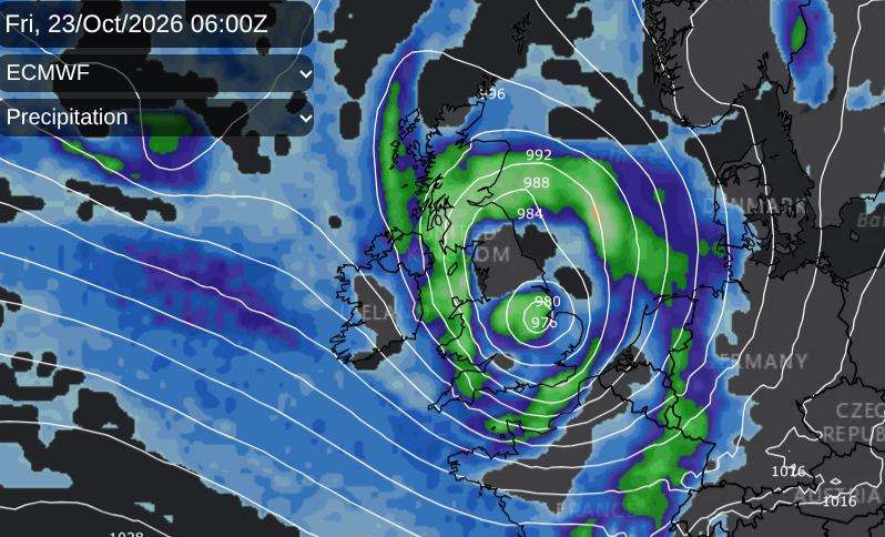
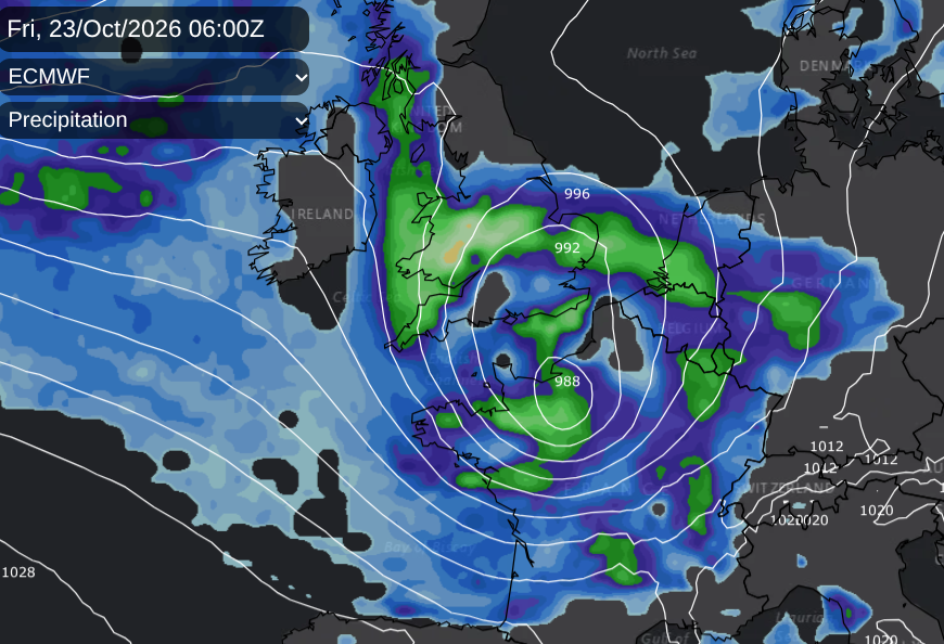
Quite a difference between ECM runs for same time on Friday morning
So still uncertainty about how deep this low will be and its track, and whether there will be widespread impacts or not. Worth watching developments this week here at Netweather.
Loading recent activity...