Updated 22nd April - Covering 29th April - 21st May 2024
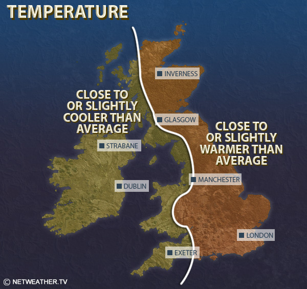
Relative to the 1991-2020 average, temperatures are expected to be 0.5 to 1.0C above average over much of the UK, mainly due to warm weather in Week 2 and potential for a warm spell around mid-May, but cooler weather particularly in Week 3 will prevent a large positive anomaly.
Rainfall totals will probably be below normal in most parts of Scotland, particularly northern Scotland, but above normal in south-western Britain, and near normal in most parts of England and north Wales.
Sunshine totals are expected to be above normal in most of Scotland, Northern Ireland and north-west England, but near or slightly below normal in the east and south of England.
This week is forecast to be warmer and wetter than average for most of the country, with blocking anticyclones to the north and north-east of Britain, particularly over Scandinavia, and low pressure often centred in the eastern North Atlantic. The low pressure will keep the weather changeable for much of the week, with some bands of rain pushing from south-west to north-east from time to time, with brighter, showery weather in between, when some of the showers may be thundery, especially in southern and eastern parts of Britain. However, it is unlikely to be persistently wet, with most areas also seeing some dry and bright weather at times. With lowest pressure often centred to the west, the winds will often be southerly, hence the warmth. There is a chance of a plume of hot weather heading into eastern England in particular, most likely early in the week, associated with southerly or south-easterly winds, which could give daytime temperatures into the mid-20s Celsius, though if this happens it is likely to only be brief.
The north and east of Scotland will probably be drier than average, although with these regions frequently being affected by south-easterly winds, low cloud will probably be a frequent issue near the east coast of Scotland, and perhaps coastal north-east England at times.
Temperatures, relative to the 1991-2020 long-term normal, will probably be above normal, especially during the first half of the week. Eastern and central parts of England may come out around 2C warmer than average. In Northern Ireland, west Wales and south-west England, nearest to the low pressure to the west, there will be a greater Atlantic influence and temperatures are likely to be less than 1C above average.
Rainfall is expected to be above normal in most parts of England and Wales, especially towards the south-west of Britain, but not unusually so. It will probably be drier than average in eastern and northern Scotland.
Sunshine totals are likely to be below normal in south-western Britain and near the east coast of Scotland, but above normal in north-west Scotland, and probably near normal in most parts of central and eastern England.
It looks probable that high latitude blocking will persist during this period, with high pressure often especially centred around Greenland. There is not a strong signal for low pressure over Britain, so confidence is relatively low in the specific weather patterns that will affect Britain, but with a Greenland high there is a chance of one or two chilly northerly outbreaks, giving potential for damaging frosts, especially in the north, but warmer spells are also probable, most likely associated with high pressure ridging across from the west and north-west at times.
Overall, it is likely to be drier and sunnier than average in north-western Britain, while the east and south of England are most likely to see wetter and/or cloudier than average weather, though it looks more likely that rainfall in most of southern and eastern England will be near normal. Temperatures are forecast to be near to slightly below normal, but with elevated global temperatures and high sea surface temperatures around the British Isles, it is unlikely to be more than 1C colder than average, and western Scotland and Northern Ireland may well come out a little warmer than average.
High pressure will again probably be more frequent than average to the north of Britain. There is a significant chance of a spell of generally warm dry sunny weather during this period, especially for northern parts of Britain, with high pressure moving from west to east. However, unsettled spells are still likely at times, especially for the west and south, as pressure is likely to be below average to the south of Britain overall. Overall, it will probably be drier than average in the north, but again with near average rainfall more likely in the south.
Temperatures overall are likely to be near to slightly above average for much of the country, possibly 1 to 2C warmer than average in some western regions. Sunshine is likely to be above normal in most western areas but some easterly and north-easterly winds, associated with high pressure centred especially over the north, are likely to bring relatively cloudy conditions at times to eastern Britain, resulting in near to slightly below average sunshine in the east of England.
Monthly weather forecast
The month ahead forecast is written by Ian Simpson and is updated every Monday.