Updated 1st December - Covering 8th - 30th Dec 2025
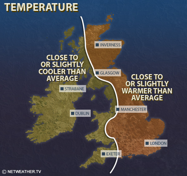
Mean temperatures are expected to be 1 to 1.5C above the 1991-2020 long-term normal overall in most regions, with some colder weather around Christmas, but generally mild weather in the first half of December.
Although it is forecast to become generally dry around Christmas, much of western Britain, particularly south and west Wales and south-west England, is likely to be wetter than average overall due to frequent wet weather in Week 2 and early in Week 3. It will be drier than average in the north and east of Scotland. Averaged nationally, precipitation totals will probably not be far from normal.
Sunshine is expected to be generally below normal during Weeks 2 and 3, except in north-east Scotland, where it will probably be considerably sunnier than average. Sunshine is more uncertain during the Christmas period. Overall, the period looks likely to be sunnier than average in north-eastern Britain but cloudier than average in the south-west.
This week looks set to be mild and changeable, with lowest pressure centred to the west and north-west of the British Isles, bringing frequent southerly and south-westerly winds. Pressure will be high to the north of Britain, but the high latitude blocking will not be conducive to bringing cold air masses over to Britain, especially as there will also be high pressure to the east, preventing cold air masses from heading in from the east. Rain bands will frequently move from south-west to north-east, and may become slow-moving at times as they stall against the blocking highs to the north and east. The rain will tend to be heaviest and most persistent in the west and south-west, and the rain belts will often tend to fizzle to some extent as they head north and east across the country.
Mean temperatures are generally forecast to be 2 to 3C above the 1991-2020 long-term average, but nearer 1C above in Northern Ireland and in northern Scotland.
It is forecast to be much wetter than average in most parts of the country, particularly much of Wales and south-west England, but it is likely to end up drier than average in parts of northern and eastern Scotland, sheltered from the southerly winds.
Sunshine is expected to be below normal in most regions, with a tendency for the periods of wet weather to be separated by grey damp weather with mist and fog patches. There will be some brighter spells as well, but probably not enough to raise sunshine totals close to the long-term normal. The exception will be the north and especially north-east of Scotland, where it is likely to be sunnier than average.
It looks probable that during this week we will see high pressure build more strongly to the east and north-east of Britain, resulting in a generally southerly airflow and low pressure systems being held further out to the west. It will probably remain wet at times, especially in the west and south-west and especially early in the week, with potential for some slow-moving bands of rain giving large rainfall totals, but with a trend towards drier and quieter weather as the week goes on, especially in the north and east of Britain. It does not look likely that there will be any widespread snow events this week, but it may turn colder later in the week, especially in the east and south of Britain, with potential for overnight frosts and fog patches, where low daytime maxima may occur in freezing fog in some areas.
Mean temperatures are thus forecast to be closer to average this week, but still generally 1-2C above average in most regions, possibly less than 1C above in parts of southern England and south Wales. It is again likely to be wetter than normal in most of Wales and western England, particularly in the south-west, but with drier than normal weather more likely in northern and eastern Scotland and near or below average precipitation in eastern England as well. Sunshine totals are again likely to be above normal in north-east Scotland, probably near normal in most other regions, but below normal in the south-west.
This period is looking likely to be dominated mainly by high pressure, which means that it will probably be generally dry and calm for the most part, with temperatures closer to average. It currently looks relatively unlikely to be a white Christmas because of the dominance of the high pressure, but at this range there is uncertainty and the possibility of a short-lived northerly or north-easterly blast with wintry showers during the period cannot be ruled out. Temperatures on the whole look likely to be closer to average, potentially on the cold side in the south, more likely to be milder than average in the north, with precipitation well below normal. Sunshine totals are uncertain, as some winter anticyclones can be sunny, but, as we saw starkly in October 2025 and early November 2024, some anticyclones in the winter half-year bring persistent anticyclonic gloom with a lot of low cloud.
Monthly weather forecast
The month ahead forecast is written by Ian Simpson and is updated every Monday.